


 CC-BY 4.0
1. Introduction
The collapse of calderas is a volcano-tectonic process associated with the eruption/depletion or the lateral migration of magma from a magmatic chamber [e.g., Williams 1941; Roche and Druitt 2001; Druitt and Sparks 1984; Lipman 1997; Gudmundsson et al. 2016; Neal et al. 2019; Sigmundsson 2019], causing the volume of rock overlaying the latter to subside and form circular to elliptical depressions that may span from hundreds of meters to tens of kilometres in diameter. This process implies the eruption up to thousands of km3 of magma, leading to a subsidence of the topographic caldera floor up to few kilometres [e.g., Druitt and Sparks 1984; Lipman 1984, 1997]. Caldera collapse is widely distributed in all the tectonic contexts [e.g., Geyer and Marti 2008] and is a paramount process in continental rift settings, where extension and thinning of the lithosphere is associated with the inlet and emplacement of magma bodies at crustal levels. The Main Ethiopian Rift (MER), in the East African Rift System, does not make exception, showing hundreds of major volcanic centres along its whole length (and surrounding areas). Some of these volcanic systems eventually evolved into caldera collapse, leading to the emplacement of large ignimbritic sheets and plinian pumice fallout deposits with a peralkaline composition that cover the rift floor and a large part of the surrounding areas [Peccerillo et al. 2003 and reference therein]. Indeed, magmatism and tectonics in the MER are crucially linked and their mutual relationships have been investigated since long time [e.g., [Corti 2009] and references therein]. Nonetheless, the active and passive role of magma ascent on tectonic processes is still widely debated [e.g., Bonini et al. 1997, 2001; Boccaletti et al. 1999; Ebinger and Casey 2001; Kendall et al. 2005; Casey et al. 2006; Corti 2008; Bastow et al. 2010; Wadge et al. 2016], and similarly is the role of pre-existing and rift-related tectonic structures during caldera collapse [e.g., Acocella et al. 2002; Rampey et al. 2010]. Calderas in the MER have focused the interest of researchers since the early stages of geological exploration of the rift, and many studies contributed to document their volcanic, petrological and structural evolution [e.g., Di Paola 1971, 1972; Mohr and Wood 1976; Mohr et al. 1980; Spera and Crisp 1981; WoldeGabriel et al. 1992; Le Turdu et al. 1999; Acocella et al. 2002; Peccerillo et al. 2003; Casey et al. 2006; Rampey et al. 2010; Giordano et al. 2014; Hutchison et al. 2016a,b; Corti et al. 2018; Lloyd et al. 2018]. Despite caldera collapse is generally accommodated by a system of outward-dipping reverse faults and inward-dipping normal ring faults [e.g., Acocella 2007], existing tectonic structures may interact with caldera-related structures, and influence the eccentricity of the caldera system. Several researches claimed, in fact, an important role of tectonic structures on the evolution of such systems, indicating that both inherited (older) and rift-related structures are key factors controlling the collapse [e.g., Acocella et al. 2002, 2004; Holohan et al. 2005, 2008; Maestrelli et al. 2020, 2021a,b; Bonini et al. 2021].
In this work, we aim to review the structural characteristics of the main collapsed calderas occurring along the magmatic segments of the MER, to discuss their setting in the frame of the tectonic evolution of the area. We finally aim to summarise in which cases tectonic structures may have influenced the development of the examined caldera collapse systems.
2. MER tectono-magmatic evolution
The MER represents the northernmost, ∼1000 km-long, sector of the East African Rift System (EARS), and results from relative motion between the Nubia and Somalia plates, which is occurring in a roughly E–W direction at rates of ∼4–6 mm∕yr [e.g., Bilham et al. 1999; Saria et al. 2014]. The MER is classically subdivided in three main sectors reflecting different stages of evolution [e.g., Hayward and Ebinger 1996; Agostini et al. 2011a]. The Northern MER (N-MER; Figure 1), extending from the Afar Depression to the Lake Koka area, is the most evolved sector, and is marked by magma-dominated processes. The Southern MER (S-MER) has its northern boundary in the Lake Awasa area, and is nowadays experiencing fault-dominated extensional processes, with limited volcanism, reflecting the youngest stage of evolution. The Central MER (C-MER), located halfway through the MER, shows intermediate features. Such different maturity stages, varying from N to S along the MER, may suggest that this rift is propagating southward toward the Turkana Depression, where it links with the Kenya Rift [e.g., Corti et al. 2019], although the timing of rift initiation and propagation is complex and still not fully understood [Balestrieri et al. 2016].
The Main Ethiopian Rift. Black lines mark the major boundary faults, while blue lines show the Wonji faults. Green triangles indicate the calderas described in this study. LK: Lake Koka. (1) Dofen Volcanic Complex (DVC); (2) Fantale; (3) Kone Volcanic Complex (KVC); (4) Gedemsa; (5) Aluto; (6) Gademotta; (7) Munesa; (8) Shala; (9) Corbetti; (10) Awasa; (11) Duguna; (12) Hobitcha. F–D: Fantale–Dofen magmatic segment; Boset–Kone magmatic segment; Aluto–Gedemsa magmatic segment.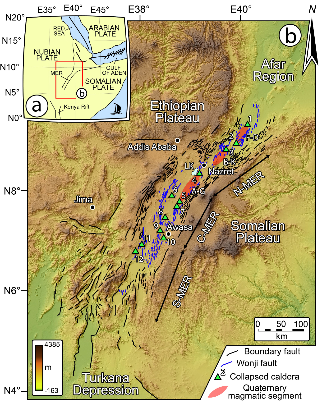
The MER is marked by large boundary faults, formed asynchronously along the rift and characterized by a vertical offset >1 km [e.g., Boccaletti et al. 1998]; these fault systems show different orientation in the N-MER, C-MER, and S-MER sectors, ranging from ∼N40° E in N-MER to N30° E in the C-MER and varying between N0° E to N20° E in S-MER (Figure 1). Geological and geophysical data indicate that the large boundary faults have been active between 11 and 2 Ma in the N-MER, whereas they are still active in the C-MER and S-MER. The floor of the present-day rift valley is characterized by a pervasive pattern of short, right-stepping en-echelon faults with throws <100 m and trending obliquely to the rift boundaries. Similarly to the boundary faults, these axial structures, classically named Wonji Fault Belt [WFB; Mohr 1962b, 1967; Meyer et al. 1975], show different characteristics in the three MER sectors: they are oriented ∼N20° E in the N-MER, ∼N12° E in the C-MER and roughly N–S in the S-MER; in the N-MER the WFB started forming at around 2 Ma, when the deformation shifted from the boundary faults to the axial portion of the rift, whereas they are in an incipient stage in the C-MER and almost absent in the S-MER [e.g., Agostini et al. 2011a]. Kinematics of WFB faults typically varies between pure dip-slip to slight oblique-slip displacement (dextral or sinistral), consistent with a roughly E–W trending Late Quaternary extension direction (N90°–95°; Agostini et al. 2011b). In the N-MER, the WFB are closely associated with the Quaternary volcanic activity, with alignment of eruptive centres and volcano-tectonic features defining the so-called axial magmatic segments [e.g., Ebinger and Casey 2001; Casey et al. 2006; Figure 1]. Active faults at the WFB cross-cut several calderas and facilitate post-caldera basaltic and silicic eruptions forming scoria cones and lava flows [Fontijn et al. 2018]. The axial segmentation of the volcano-tectonic activity is mimicked in a similar segmentation at depth. Tomographic analysis revealed indeed segmented low velocities zones, interpreted as the loci of enhanced melt production from the mantle, suggesting that magma generation and faulting at surface are intimately linked [Keranen et al. 2004; Bastow et al. 2005]. The development of the WFB in the N-MER has been interpreted as reflecting a change in the deformation style from ∼2 Ma [e.g., Meyer et al. 1975], with the deactivation of the large-throw boundary faults and migration of strain and volcanic activity to the centre of the rift depression [Morton et al. 1979]. As outlined above, transition from axial tectono-magmatic activity and magma-dominated deformation in the N-MER to marginal faulting with limited volcanism in the S-MER has been interpreted to reflect a North to South transition from more advanced to less advanced rifting stages.
Extension in the Ethiopian region was predated by a complex pre-Tertiary tectonic history responsible of several heterogeneities that influenced rift localization and evolution at both regional scale and local scale [e.g., Mohr 1962b; Keranen and Klemperer 2008; Bastow et al. 2008; Keranen et al. 2009]. This phase was followed by an intense basaltic volcanic activity (since ∼45 Ma) emplacing the so-called Trap series, characterised by tholeiitic to alkaline lava flows [e.g., Kieffer et al. 2004; Rooney 2017] intercalated with silicic volcanics to form an up to 3000 m volcanic pile [e.g., Mohr and Zanettin 1988]. This activity continued during the Miocene with the building of large volcanic edifices on the plateaus surrounding the rift [e.g., Kieffer et al. 2004], and with a second phase of widespread basaltic activity between 12 and 8 Ma [e.g., Bonini et al. 2005]. Later on, at ∼6–8 Ma, a major pulse in volcanic activity was confined within the developing rift valley; this activity was characterized by the alternate eruption of large ignimbrite deposits and basaltic magmatism [Boccaletti et al. 1999; Trua et al. 1999]. During the Quaternary, this typical bimodal magmatic activity, mainly occurring as pulsed phases, localized in the axial magmatic segments of the N-MER [e.g., Casey et al. 2006; Hutchison et al. 2016a] synchronously to WFB development, generating trachyte and rhyolite pyroclastites from central emission points (strato-cones and caldera complexes) and subordinated basalts from fissural eruptions [e.g., Chernet and Hart 1999; Boccaletti et al. 1999; WoldeGabriel et al. 1999; Casey et al. 2006].
The history of the MER, since pre-Tertiary times, therefore shows how tectonics and volcanism are interrelated, indicating that inherited structures at places influenced volcanic activity by localizing eruptions, aligning volcanic centres and guiding dyke orientation [e.g., Wadge et al. 2016]. It was proposed that large silicic centres were emplaced at the tip of magmatic segments, where reduced stress favoured long residence time and consequent magma evolution [e.g., Le Turdu et al. 1999; Peccerillo et al. 2003; Figure 1]. Alternatively, other works suggest that deformation at the centre of the segments is mainly controlled by magmatism, while it is predominantly brittle at the segment tips [e.g., Kurz et al. 2007]. Several volcanoes along the MER evolved as caldera collapse structures, and many authors suggested a role of inherited faults on the development of certain caldera features [e.g., Acocella et al. 2002]. Besides, other studies suggest that tectonic activity was subordinated to magmatism, and that collapsed calderas were not controlled by inherited fabrics [e.g., Casey et al. 2006]. In the following paragraphs, we review the main (twelve) caldera collapses (Figure 1), highlighting their structural setting and aiming to disclose whether tectonic processes played a role during their evolution.
3. Collapsed calderas along the MER
We describe collapsed calderas and their structural setting from N to S, grouping them according to the three main rift sectors (N-MER, Figure 2; C-MER, Figure 3; S-MER, Figure 4). This choice reflects the difference in the evolutionary stage of the three sectors, consequently influencing the setting in which caldera collapse occurred. Characteristics of Ethiopian calderas have been reported in Table 1, which has been compiled from the literature and new data deriving from this study.
(a) Dofen Volcanic Complex. This volcanic complex, defining the northern tip of the Dofen Fantale magmatic segments, shows a small collapsed caldera. Structures and emission points are mapped after Casey et al. [2006]. (b) Fantale Caldera showing NW–SE elongation. Caldera and tectonic structures are mapped after Acocella et al. [2002]. (c) Kone Volcanic Complex (KVC), which is composed of the remnants of the Birenti Caldera (Bi), Kone Caldera (Ko) and the Korke Embayment (Kr). MtB: Mount Birenti (black triangle). Caldera location is indicated in Figure 1. Caldera and tectonic structures are mapped after Acocella et al. [2002] and Rampey et al. [2010]. (d) Gedemsa Caldera showing two major rectilinear caldera walls. Caldera and tectonic structures are mapped after Korme et al. [1997], Acocella et al. [2002] and Hutchison et al. [2016a]. Newly mapped tectonic structures are interpreted on 30 m resolution ALOS DEMs. Black thick lines indicate caldera structures (dashed black lines for uncertain caldera structures), while blue lines indicate tectonic structures. Red stars indicate volcanic emission points. Thick red dashed lines indicate fault-controlled caldera margin, as inferred by Acocella et al. [2002] and Hunt et al. [2019].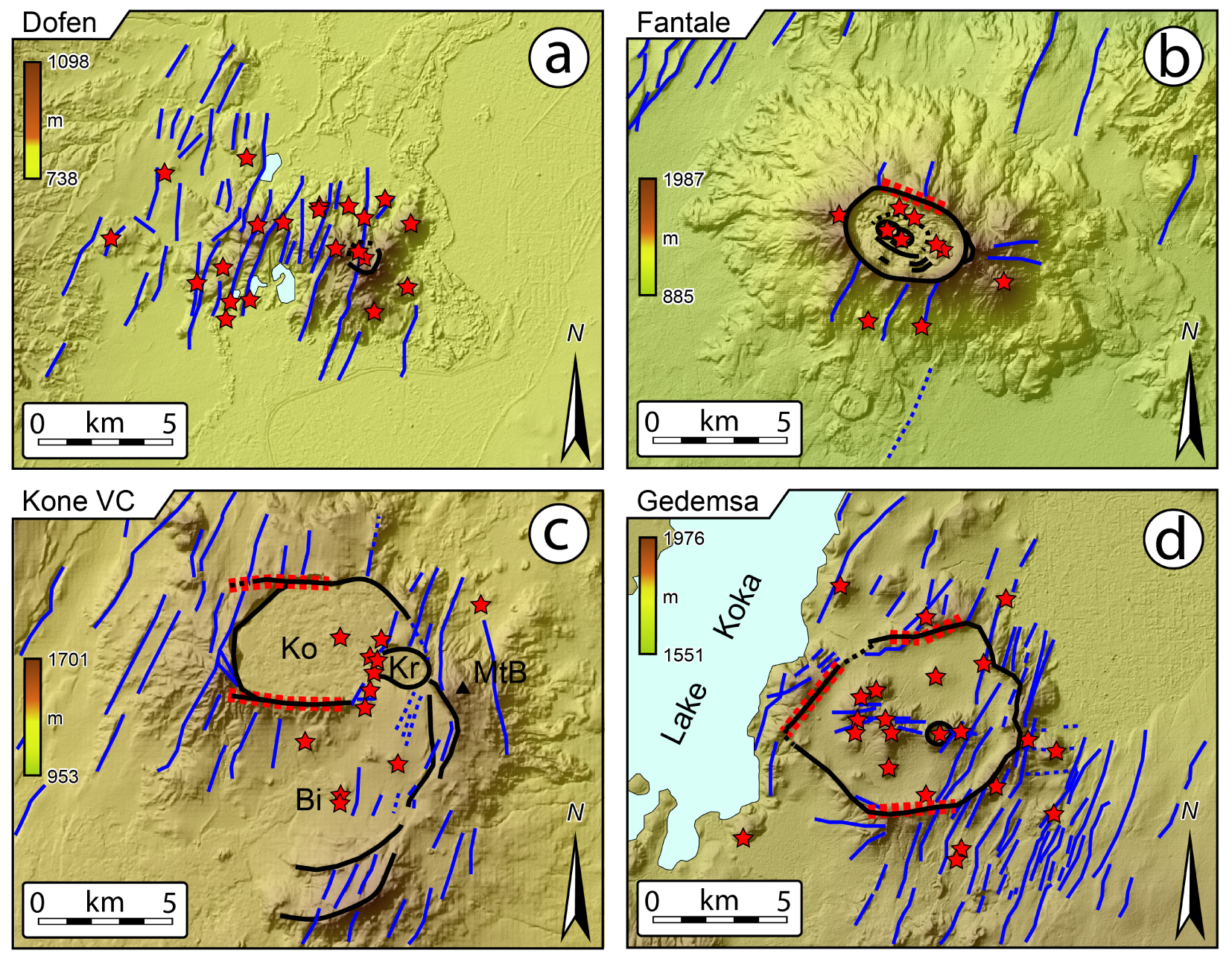
(a) Aluto Caldera (Al) and the remnants of the Gademotta (Gad) and Munesa (Mun) calderas. Structures are redrawn after Hutchison et al. [2016a,b]. L. Lan.: Lake Langano. (b) Shala Caldera. Structures are redrawn after Hutchison et al. [2016a,b]; Mohr et al. [1980] and Le Turdu et al. [1999]. L. Lan.: Lake Langano; SSFS: Southern Shala Fault System; ESFS: Eastern Shala Fault System; WLF: West Langano Fault. (c) Corbetti (Co) and Awasa (Aw) calderas. L. Aw.: Lake Awasa. Structures are redrawn and modified after Di Paola [1971], Korme et al. [1997], Hutchison et al. [2016a], Lloyd et al. [2018] and Hunt et al. [2019]. Caldera location is indicated in Figure 1. Symbol and legend are as in Figure 2.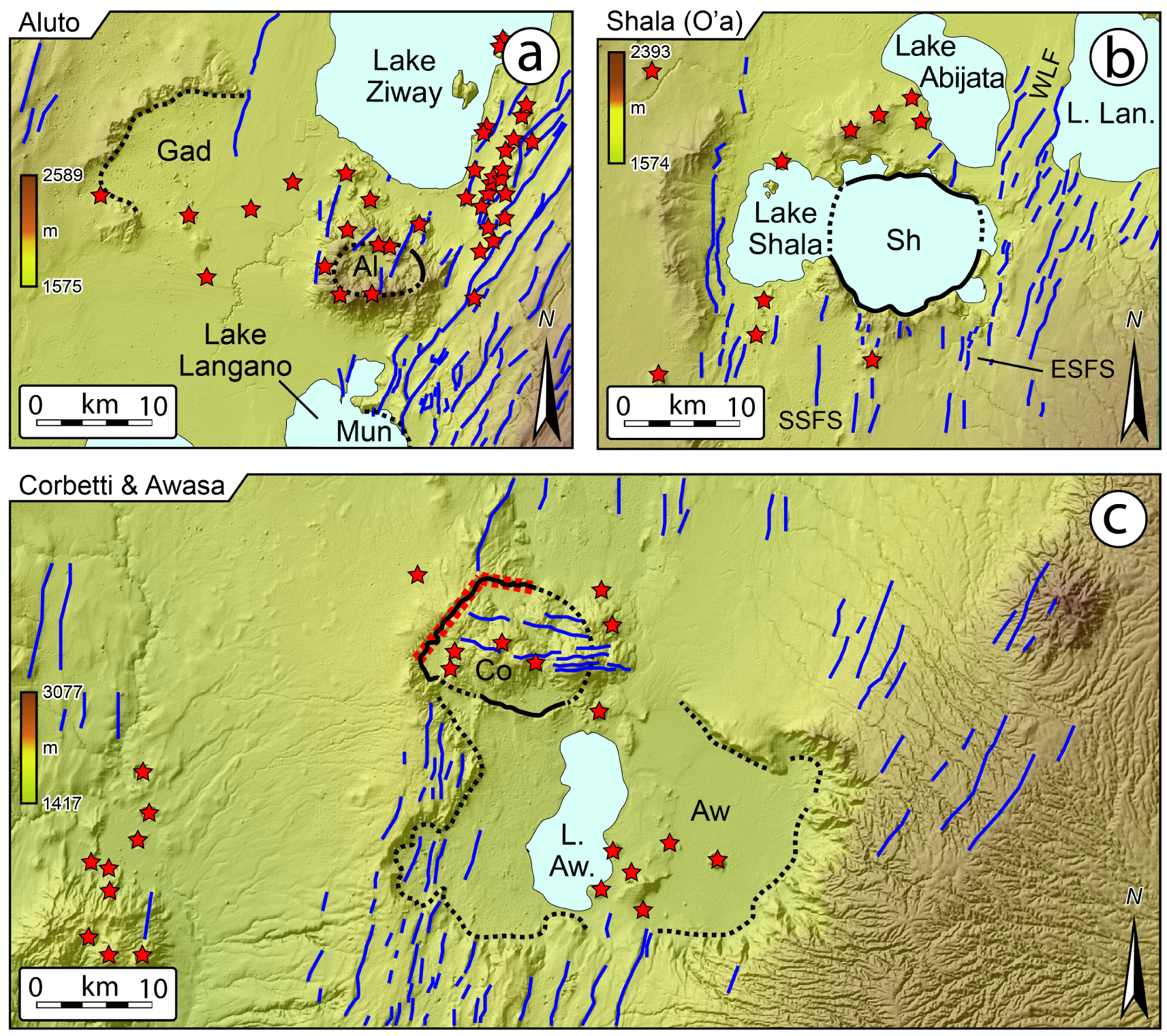
Duguna volcanic complex with summit caldera collapse and the remnants of the Hobitcha Caldera. Structures are redrawn after Corti et al. [2013], Chernet [2011] and Minissale et al. [2017]. Black lines indicate rift boundary faults, while blue lines indicate the axial Wonji Faults. All other symbols are as those in Figure 2. Caldera location is indicated in Figure 1.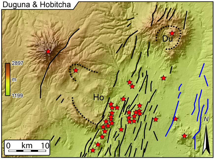
Summary of caldera features described in this work and compiled from literature
| Name | MER sector | Lat. | Long. | Age oldest | Age youngest | Axial ratio (LA∕SA)(3) | Long axis trend | Rocks | Caldera features | Area | Strain ln(LA∕SA)(3) |
|---|---|---|---|---|---|---|---|---|---|---|---|
| Dofen | N | 9.35° | 40.13° | 1.7 Ma(1) | Historic | 2.56(3) ed | N113° E | Trachy-basaltic lava flows, rhyolite flows and domes(1) | Summit caldera on a strained magmatic edifice | 1 × 1 km, considering the summit collapse | 0.940(3) |
| Fantale | N | 8.98° | 39.90° | 168 ± 38 Ka(2) | 1820 a.d.(3) | 1.58(2) 1.67(3) 1.77(3) 1.61(3) 1.64(3) | N112° E(2) N111–114° E(3) N107 ± 4° E(4) | Ignimbrite, pumices, ash fallout, obsidian, rhyolites, basaltic lavas(3) | Nested inside major caldera; Fault-controlled margins | 2.9×4.4 km(2) 2.5×4.5 km(4) | 0.457 0.513(3) 0.571(3) 0.476(3) |
| Kone (3 main cald.: Kone or Gariboldi, Korke, Birenti) | N | 8.84° | 39.69° | <0.32 Ma(5) | 1810 a.d.(5) | 1.49(3) | N94 ± 17E(4) | Pumices and ash fallout, ignimbrites and rhyolitic lavas, trachytes, basalt flows(3) | Nested; Fault-controlled margins | 5.0×7.5 km(4) 95 km2(5) | 0.399 |
| Gedemsa | N | 8.36° | 39.17° | 0.88 Ma(3) 0.8 Ma(4) | 0.29–0.2 Ma(3) 0.32–0.26 Ma(6) 0.1 Ma(4) | 1.315(2) 1.23(3) | N75° E(2) N86° E(4) | Trachytic, rhyolitic and obsidian lavas, Ignimbrite, surges and fallout(4,7) | Fault-controlled margins | 7.3×9.6(2) 7×9 km(4) | 0.274 0.207(3) |
| Aluto | C | 7.74° | 38.78° | 0.27–0.15 Ma(8) 316–306 Ka(9) | 21–9.4–2 Ka(8) >60 Ka(9) | 1.72(2) | N90° E(8) | Trachytic, Ignimbrites, pumices, obsidian(9) | 8.6×5.0 km(9) | 0.542 | |
| Shala (O’a) | C | 7.47° | 38.50° | 0.24 Ma(8) | 0.18 Ma(8) | 1,143 (O’a) | N105–110° E | Ignimbrite, pumices, rhyolites, basalts(4,8) | Nested? | 16×14 km (O’a) | 0.133 |
| Corbetti | C/S | 7.20° | 38.36° | 0.24 Ma(8) | 0.18–0.1 Ma(8,11) | 1.43(2) | N104° E(2) N135° E(7,10) | Ignimbrite, pumices(9) | Nested? Fault-controlled margins | 12×10 km(7,10) | 0.357 |
| Awasa | C/S | 7.04° | 38.43° | 1.0 Ma(12) 1.85–1.1 Ma(11) | ∼1900 a.d.(12) | 1.75 1.333 | ≈E–W* | Ignimbrite | Nested?; Strongly eroded | 35 × 20 30×40 km(12) | 0.560 0.288 |
| Duguna | S | 6.91° | 38.01° | 0.46–0.43 Ma(14) | ? | 1,333 | N35° E | Pumices, ash fall(13) | 8 × 6 km | 0.288 | |
| Hobitcha | S | 6.79° | 37.88° | ? | ? | ? | N110° E | Rhyolites | Strongly eroded | ∼10 km diam. | ? |
Reference legend: (1) Chernet 2005; (2) Hunt et al. 2019 and reference therein; (3) Casey et al. 2006; (4) Acocella et al. 2002 and reference therein; (5) Rampey et al. 2010 and reference therein; (6) Peccerillo et al. 2003; (7) Di Paola 1971; (8) Le Turdu et al. 1999; (9) Hutchison et al. 2016b and reference therein; (10) Di Paola 1972; (11) Hutchison et al. 2016a; (12) Newhall and Dzurisin 1988; (13) Corti et al. 2013 and reference therein; (14) Bigazzi et al. 1993. Where not specified the data here reported belong to this study. ed.: edifice. The strain (or natural strain) is calculated, following Casey et al. [2006], as the natural logarithm of the caldera long axis (LA) and short axis (SA) ratio.
∗ The elongation of Awasa is roughly E–W, but the presence of erosional embayments does not allow for a clear definition of the caldera major axis.
3.1. N-MER calderas
3.1.1. Dofen volcanic complex (DVC)
The felsic Dofen volcanic complex (DVC; Figures 1b and 2a) is located at the northern tip of the Dofen–Fantale magmatic segment and is represented by a NW–SE elongated relief (Figure 5). This relief has been interpreted to be a strained volcanic edifice in a ∼N110° E direction [Casey et al. 2006], nowadays dissected by several NNE–SSW trending faults and fractures (Figures 2a and 5). The volcanic system lays, together with the Fantale Caldera more to the south, within an east-dipping half-graben bounded by a 60–80 m-high fault scarp [Casey et al. 2006]. K/Ar dating ascribes the Dofen complex to 1.7 Ma but historical lava flows testify ongoing activity [Chernet 2005; Table 1]. In its central portion, normal faults with throw >100 m dismantled what Casey et al. [2006] refer to a “caldera complex”. Nonetheless, no clear evidence of large caldera structures can be interpreted from DEMs, except for the small depression (∼1 km in diameter) occurring in the eastern portion of the volcanic complex. Several emission points align with NE–SW trending structures, interpreted by Casey et al. [2006] as the surface expression of dyke segments.
Caldera elongation and regional structures orientation for the examined volcanic and caldera complexes in along the MER. Rose diagram (length weighted) shows mapped tectonic structures reported in Figures 2, 3 and 4. Red line indicate the average trend of tectonic structures while green lined shows the trend of caldera elongation corresponding to the caldera major axis (see also Table 1). Red thick dashed lines indicate the inferred geometry of the calderas.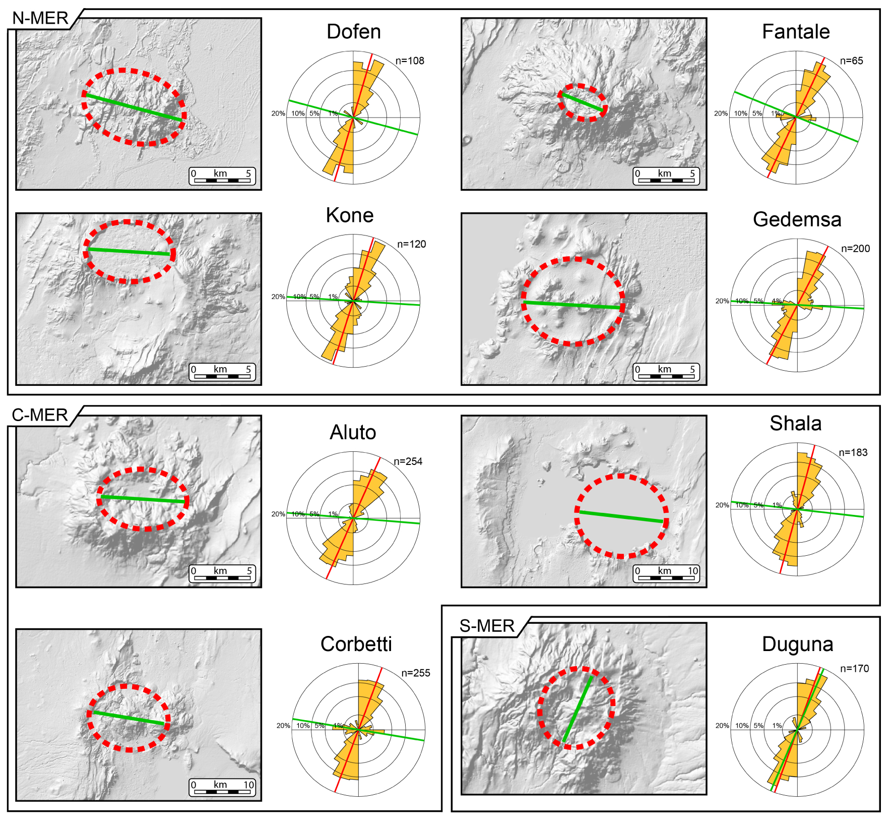
3.1.2. Fantale caldera
Fantale is one of the most active volcanoes in the MER and is located at the southern tip of the Dofen–Fantale magmatic segment [Figure 1; Casey et al. 2006]. Its volcanic history was dominated by eruption of intermediate and silicic volcanics, ranging from ignimbrite pumices and ash falls in the early stages to lava flows (obsidian and rhyolites) in later stages [Hunt et al. 2019]. Obsidian flows and basaltic lavas were erupted in 1820 [Gibson 1969]. Acocella et al. [2002] identified in the area NNE–SSW trending WFB faults (mean trend N23° E ± 5°), with a maximum displacement of 100 m, and described the elliptical caldera (∼2.5 × 4.5 km, or 2.9 × 4.4 km, following Hunt et al. 2019; Table 1) as characterized by a topographic subsidence of 100 m (Figures 2b and 5; Table 1). Inside Fantale, a smaller nested caldera (40 m deep) is visible. WNW–ESE trending vertical faults crosscut the caldera rim and several monogenic vents are reported by Acocella et al. [2002] in the caldera depression as well as along the rim, organized in trails sub-parallel to caldera elongation. Outside the caldera, Acocella et al. [2002] report vent distribution as mainly controlled by NNE–SSW trending Wonji structures, with no evidence of WNW–ESE trending structures. Casey et al. [2006] reported that the ∼N trending faults (N10° E) displace historical fissure lava flows erupted from the southern flank of the Fantale volcano in 1810 and 1820 [e.g., Williams et al. 2004]. Hunt et al. [2019] suggest that the rectilinear, northern caldera margin may be controlled by a fault (Figure 2b). Finally, Temtime et al. [2020] investigated and modelled rhyolitic dyke intrusion accompanied by ground fractures that occurred in 2015 NW of Fantale Caldera. The trend of the ground fractures ranges between ∼35° and 5° and the modelling suggested that the dyke strike ∼29° ± 2° [Temtime et al. 2020].
3.1.3. Kone volcanic complex (KVC)
The Kone volcanic complex (KVC, Rampey et al. 2010; Figures 1 and 2c; Table 1), also referred as Gariboldi, is a major Quaternary composite caldera system where at least seven Pleistocene to Recent caldera collapses (with eruption in historic period) were recognised [Mohr 1962a; Cole 1969; Rampey et al. 2010]. Located ∼30 km SW of Fantale, it represents the northern tip of the so-called Boset–Kone Magmatic segment (Figure 1) and is composed of three superimposed major caldera depressions, respectively named Birenti, which is nowadays visible as several isolated segments of caldera wall, Kone and Korke [Cole 1969; Rampey et al. 2010]. The nature of the remnants of the caldera walls suggest that the Birenti Caldera is composed of at least two nested calderas (Figure 2c), with an inferred diameter of ∼11 km and an area of ∼95 km2 for this composite caldera collapse that is the oldest of the KVC [Rampey et al. 2010]. Other data about the KVC can be found in Table 1.
The Kone Caldera rim is described by Rampey et al. [2010] as a horseshoe structure opening to E with the northern portion of the rim extending SW (∼350 m), where ∼200 m of caldera wall material are exposed together with ∼150 m of pyroclastic caldera forming deposits (Figure 2c). Rampey et al. [2010] reported that the Kone Caldera wall is moderately incised by post collapse erosion and that the southern part of the western margin is cut by a E–W trending fault. In the surrounding areas, Acocella et al. [2002] mapped NNE–SSW trending WFB faults (N20° ± 3°) (Figure 5), and described alignments of monogenic vents in the eastern portion of the caldera, trending approximately N17°, therefore subparallel to regional NNE–SSW faults.
3.1.4. Gedemsa caldera
The Gedemsa Caldera is located east of Lake Koka, ∼80 km south of the KVC (Figure 1), along the axial part of the MER [Acocella et al. 2002] and in the proximity of the northern tip of the Aluto–Gedemsa magmatic segment [Casey et al. 2006 and reference therein; Figure 1]. Its activity, clustered in three distinguishable phases (pre-caldera, caldera and post caldera activity), as detailed by Hutchison et al. [2016a] and Hunt et al. [2019], mainly produced silicic with few subordinated mafic and intermediate products [e.g., Di Paola 1972]. Lavas (trachytes, rhyolites and obsidians) and pyroclastics (ignimbrites, surges and fallout) were mainly erupted, compositionally ranging from hawaiite to rhyolite, with mafic components erupted only during post-caldera activity [Peccerillo et al. 1995]. Di Paola [1972] indicated that the NNE–SSW regional faults affect the collapsed caldera, especially in its eastern portion. Hunt et al. [2019] suggest that some of the caldera margins, expressed as rectilinear faults may be controlled by inherited structures (Figure 2d). Acocella et al. [2002] identified the same NNE–SSW trending faults and characterized them as extensional WFB fractures and faults (average trend N22° ± 3°) with maximum vertical displacement of ∼100 m (Figures 2d and 5; Table 1). The northern and southern rims have an E–W strike, while to the west and to the east NNE–SSW rectilinear faults mark the caldera rim, defining an overall rhomboidal shape.
3.2. C-MER calderas
3.2.1. Aluto caldera
Aluto is a major silicic eruptive centre situated in the tectonically controlled lacustrine Ziway-Shala basin [e.g., Di Paola 1972; Le Turdu et al. 1999; Benvenuti et al. 2002], which experienced caldera collapse with large explosions and associated extensive ignimbrite deposits [Hutchison et al. 2015, 2016b]. This volcano lays between the Gademotta Caldera remnants (20 km to the NE) and the Munesa Caldera remnants to the South, the latter being masked by Lake Langano (Figure 3). These two large silicic calderas, nowadays exposed only in scattered and highly eroded portions, ceased their activity before 1 Ma and are considered two of the largest calderas developed along the MER [Hutchison et al. 2016b, and reference therein; Table 1]. A detailed description of the Aluto eruptive history is provided by Hutchison et al. [2016a,b], which defined a three-stage evolution, depicting pre-caldera, caldera and post-caldera activity. Nowadays, the Aluto Caldera shows a marked E–W trending elongation (Figure 5), despite no major faults with a similar trend are observed inside the depression, or outside, in the proximity of the caldera (Figure 3a). At places, the caldera rims are dissected by N–NE-trending Wonji faults (Figure 5), which are absent in the area between Aluto and Gademotta remnants. Higher density of such faults is observed east of the Aluto Caldera, near the remnants of the Munesa Caldera, where several faults structures are visible in correspondence of the Lake Langano banks (Figure 3a) and that extends also below the lake surface, as highlighted by geophysical data [Le Turdu et al. 1999].
3.2.2. Shala (O’a) caldera
Shala, or O’a, Caldera lays ≈40 km south of the Aluto Caldera, in an area that is completely obscured by Lake Shala. The most evident remnants of this large collapse (that occurred around 0.24 Ma, Mohr et al. 1980; Le Turdu et al. 1999, Table 1) are the northern and southern scarps, which mostly cut ignimbrites and pumices and subordinately rhyolitic lavas [Di Paola 1972]. Toward east and west, the caldera margins were eroded and the entire caldera edifice including the caldera ring faults were masked by the lake [Mohr et al. 1980]. Connection of rim remnants suggests a limited E–W elongation of the caldera collapse area (Figure 5, Table 1), but no direct data can be obtained about internal caldera structure and morphology. Several faults belonging to the WFB are visible around the Lake Shala with an overall NNE–SSW trend, some of which were named by Le Turdu et al. [1999] as Southern Shala Fault System and Eastern Shala Fault System (Figure 3b). The WFB was active during the Shala volcanic complex evolution and appears to have been active up to the Holocene [Mohr et al. 1980; Le Turdu et al. 1999]. No E–W trending faults are observed in the caldera proximity (Figure 3b), but Mohr et al. [1980] report sparse ESE-trending transverse faults on the caldera eastern side.
3.2.3. Corbetti caldera and Awasa caldera remnants
The Corbetti Caldera is located ≈30 km southwest of the Shala Caldera, close to the Awasa (or Hawassa) Caldera remnants in the Lake Awasa Basin [Hutchison et al. 2016a; Figure 3c]. The Corbetti Caldera has been the object of many studies in the past and in recent times, which have detailed its major features [Di Paola 1971, 1972; Hunt et al. 2019; Table 1]. Besides, pre-caldera activity was followed at Corbetti by large ignimbrite eruption and caldera formation around 182 ± 28 ka BP [Hutchison et al. 2016a]. Based on geodetic and magnetotelluric data, Lloyd et al. [2018] hypothesize the presence of a ≈E–W trending regional structures extending down to ∼30 km in the crust and associated magma emplacement and caldera collapse elongation (Figure 5). Intra-caldera structures show a similar trend (Figures 3a and 5) and crosscut the inferred caldera rim on its eastern side, and align with post-caldera volcanic emission points. Nonetheless, outside the caldera no E–W trending structures are observed, and faults in the Corbetti–Awasa area show an NNE–SSW trend consistent with the WFB (Figure 5). Hunt et al. [2019] report that some of the caldera margins characterised by a rectilinear trend may be controlled by faults (Figure 3c). The Awasa remnants, covering an area of ≈35 × 20 km (Table 1), testify a much larger collapse (one of the three largest occurred along the C-MER, with Munesa and Gademotta collapses; Hutchison et al. 2016b, and references therein). This caldera experienced its major caldera-forming eruption around 1.85–1.1 Ma [WoldeGabriel et al. 1990] and is nowadays strongly eroded, with the caldera floor partly obscured by Lake Awasa.
3.3. S-MER calderas
3.3.1. Duguna and Hobitcha
The Duguna Caldera [Newhall and Dzurisin 1988] is a large volcanic centre located at the northernmost tip of the S-MER, ≈20 km southwest of the Awasa Caldera. This volcanic complex shows a summit caldera collapse, which produced pumices and ashfall deposits [Chernet 2011], roughly elongated along a NE–SW trend (Figures 4 and 5), and covers an approximate area of ≈8 × 6 km (Table 1). Ages of 430–460 ka have been reported for the eastern flank of the Duguna volcano [Bigazzi et al. 1993; Table 1]. The pre-caldera volcanic edifice is crosscut by NE–SW trending rift boundary faults (Figures 4 and 5), and Wonji faults with a similar trend surface southeast of Duguna, along the axial sector of the MER [Corti et al. 2013]. The boundary faults also seem to align with several minor volcanic emission points and crosscut the remnant of the larger Hobitcha Caldera remnants, a horseshoe-shaped rhyolitic centre, with a diameter of ∼10 km [Chernet 2011; Corti et al. 2013; Table 1].
Sketch inspired and modified from Robertson et al.] [2015], and reference therein] summarizing the possible mechanisms contributing to caldera elongation. (a–c) Caldera elongation controlled by an elongated magma chamber. This may occur as a result of (a) tectonic strain (in analogy to the borehole breakout mechanism; e.g., Mazzarini et al. 2010), (b) elongation along induced fractures/dykes or (c) magma emplacement along regional reactivated structures. (d) Nested collapse may control the overall composite caldera elongation. (e) The presence of existing discontinuities can produce elongated caldera depressions. Other shallow crustal processes (not shown in the figure; e.g., asymmetrical subsidence, pre-collapse topography) can produce similar elongation [Robertson et al. 2015]. (f–g) Post-collapse processes, such as erosion or strain of the caldera structure due to regional stretching (i.e., parallel to the direction of extension and orthogonal to regional faults that therefore dissect the caldera structure), may finally contribute to the caldera elongation. See the text for details. SHmax: maximum horizontal stress; Shmin: minimum horizontal stress; C1 and C2: primary and subsequent collapses.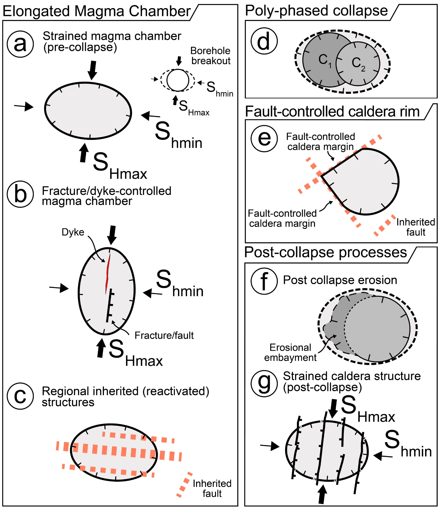
4. Discussion: interaction between calderas and regional tectonics in the MER
The direction of extension along the MER was reconstructed by several authors based on structural data and GPS vectors, suggesting a direction of horizontal stretching ranging between N135° E and N105° E [e.g., Chorowicz et al. 1994; Bilham et al. 1999; Chu and Gordon 1999; Acocella et al. 2002; Keir et al. 2006]. Nonetheless, other studies suggested a partly different extension direction trending around N90°–100° [e.g., Bonini et al. 1997; Boccaletti et al. 1998; Fernandes et al. 2004; Pizzi et al. 2006; Agostini et al. 2011b; Saria et al. 2014; Stamps et al. 2021]. It is well known that elongated calderas may reflect the regional stress field [e.g., Bosworth et al. 2000, 2003] and thus extension along the MER may have controlled caldera elongation [Casey et al. 2006]. Notably, the elongation of the examined calderas (except for the summit Duguna Caldera) is mostly parallel to the proposed N90°–100° trending extension direction acting on the MER (Figure 5).
Nonetheless, several mechanisms were proposed in literature to justify caldera elongation and the trend of associated volcano-tectonic features (e.g., vent alignments). Robertson et al. [2015] summarized the main mechanism to explain caldera elongation along the Kenya Rift. These authors report that caldera elongated shape may be induced by (i) the pre-collapse elongation of the underlying magma chamber (Figure 6a, b, c), which may be in turn driven by other processes, as explained below, (ii) poly-phased collapse resulting into nested calderas (Figure 6d), assuming an overall elongated geometry, (iii) fault-controlled caldera rim (Figure 6e) and (iv) post-collapse events or continued stretching (Figure 6f, g). More specifically, the elongation of the magma chamber can depend upon magma migration and emplacement along pre-existing structures [e.g., Montanari et al. 2020; Figure 6c] or by the orientation of the stress field (Figure 6a, b), such that the long caldera axis may be parallel to the minimum horizontal stress (Figure 6a), assuming a mechanism analogue to borehole breakout [e.g., Bosworth et al. 2000, 2003], or the maximum horizontal stress [Figure 6b; e.g., Wadge et al. 2016]. In this frame, the analysis of associated volcanic features may help to discern between the two latter cases [e.g., Bonini 2012]. Poly-phased collapse is likely the simplest mechanism to explain caldera elongation: subsequent collapse and nested caldera formation may in fact induce an apparent composite caldera elongation, which may, or may not, reflect an underlying elongated magma chamber (Figure 6d). Collapse may induce caldera elongation when in presence of inherited linear crustal structures, reactivated during the collapse or when distorted by local structures [e.g., Acocella et al. 2002, 2004; Holohan et al. 2005, 2008; Maestrelli et al. 2020, 2021a,b] (i.e., fault-controlled caldera rim, Figure 6e). Post-collapse events can finally at least in part contribute to create elongated caldera depressions (e.g., post collapse erosion or continued strain due to regional stretching after caldera collapse, Figure 6f, g). These mechanisms, summarized by Robertson et al. [2015], can be considered valid worldwide and therefore, their applicability can be also tested for calderas occurring along the MER.
In this regard, Acocella et al. [2002] suggested a forcing of structural inheritance in controlling the elongation of the Fantale, Kone and Gedemsa calderas (Figures 2, 5). Nevertheless, no major ESE–WNW inherited structures (i.e., parallel to caldera elongation) are exposed in the surrounding areas of the caldera (Figures 2, 5), but they occur on the plateaus as large-throw sub-vertical faults, suggesting that they may be present as buried structures beneath the rift floor (Figure 6c). These sub-vertical regional structures may have been reactivated as left-lateral strike slip structures during E–W rifting, creating preferential local areas of unclamping favourable for magma ascent and emplacement, consequently forcing caldera elongation and generating vent alignments (Figure 6c). In this model, the Wonji faults do not control the caldera structural setting and simply influence post-caldera activity by localizing points of emission outside the caldera [Acocella et al. 2002; Fontijn et al. 2018]. At the Corbetti Caldera (Figures 3, 5), Lloyd et al. [2018] hypothesize the presence of an E–W trending regional structure extending downward into the crust for at least 30 km. They propose that these structures may be related to the Goba-Bonga lineament, as also supported by detailed geological-structural analysis [Corti et al. 2018] and geophysical data [Lavayssière et al. 2019], and suggest a similar model to Acocella et al. [2002] for magma emplacement and caldera elongation. Conversely, Casey et al. [2006] suggested an active role of regional stretching on the elongation of the calderas along the MER, as the mechanism sketched in Figure 6g. Besides, the regional stress field may induce magma chamber elongation, as sketched in Figure 6a. In our interpretation, these two mechanism can explain the average E–W to ESE–WNW trend of caldera elongation along the MER, which is coherent with the ≈E–W direction of regional extension (cf. with Figure 5). Out of the examined calderas, only Duguna shows a moderate NNE–SSW elongation (Figure 5), and we speculate that it may follow the trend of regional structures (Figure 6b), which is there represented by the boundary faults (Figure 4).
Poly-phased collapse, producing nested calderas, was suggested by Rampey et al. [2010] for the Kone Caldera, in contrast with the hypothesis of a tectonic control exerted by E–W regional structures proposed by Acocella et al. [2002], as well as with the stretching of the magma chamber under regional stress. Likely, poly-phased collapse also occurred at other calderas along the MER (e.g., Shala Caldera). Nonetheless, for several calderas showing marked elongation, it unlikely represents the main mechanism leading to an elliptical shape, since no other major nested calderas are observed (e.g. Fantale, Aluto and Corbetti calderas).
Inherited local structures may have played a role during the collapse of specific calderas along the MER (e.g., reactivated as caldera faults). For example, some margins of the Fantale, Kone, Gedemsa and Corbetti calderas (Figures 2 and 3) are indicated by Acocella et al. [2002] and Hunt et al. [2019] as fault-controlled, and likely resulted from the reactivation of inherited structures during the collapse (Figure 6e).
Although post-caldera erosion (Figure 6f) represents an active mechanism occurring at several calderas, as testified by many embayments visible along caldera margins [Hunt et al. 2019; e.g., Awasa and Shala calderas, Figure 3b, c], this process seems to act at a different (smaller) scale to justify the marked elongation of some of the examined calderas (e.g., Fantale, Corbetti), where caldera margins are still well traceable. Therefore, in our interpretation it cannot be considered as a main mechanism shaping elongated calderas in the MER.
Overall, based on the above considerations, we infer that elongation of the magmatic chamber and the regional stretching are the most effective mechanism controlling the elliptical caldera geometry of the considered MER calderas (Figure 5). As noted earlier, the first process may reflect the influence of the regional stress (Figure 6a) or possibly the effect exerted by inherited crustal structures along which magma is preferentially emplaced as an oblate magma body, resulting afterward in an elongated collapse (Figure 6c). Beside, regional stretching may at least in part contribute to elongate calderas after collapse [Casey et al. 2006; Figure 6g], as several calderas are dissected by regional faults trending to an high angle to the caldera major axis (i.e., the caldera elongation; Figure 5). Nonetheless, this mechanism cannot represent the exclusive mechanism, as normal faults observed in the area are not sufficient to justify caldera elongation. We therefore suggest that these processes (i.e., magmatic chamber elongation, inherited crustal structures reactivation and regional stretching) are the main concurring mechanisms driving the formation of elongated calderas along the MER, although other processes may contribute to caldera elongation globally (Figure 6d, e, f).
5. Concluding remarks
In this study, we have reviewed the structural characteristics of the main collapsed calderas that occur along the axis of the Northern, Central and Southern sectors of the Main Ethiopian Rift. These perakaline calderas bear a strong linkage with the tectonics of this continental rift, showing several features suggesting a tectonic control on their development. Specifically, most of the examined calderas have a moderate to marked elongation and some of them (e.g., Fantale, Kone, Gedemsa and Corbetti calderas) have experienced a tectonic control exerted by pre-existing faults reactivated during the collapse (i.e., fault-controlled caldera rim; Figure 6e). Although poly-phased collapse leading to nested calderas (Figure 6d) may explain the elongation of some of the examined calderas (e.g., Shala and Kone volcanic complexes), it is not observed at other calderas, for which different mechanisms should be taken into account. Finally, post-collapse processes (e.g., caldera erosion; Figure 6f) likely act at a different (local) scale to justify markedly elongated calderas. We therefore propose that the main mechanisms responsible for caldera elongation along the MER are likely related to the elongation of the subsurface magma body and to regional stretching. Magma chamber elongation may depend on the regional stress field (Figure 6a, b) or the presence of regional existing structures reactivated during the emplacement of magma (Figure 6c). Regional stretching may at least partly contribute to elongate circular collapsed calderas (Figure 6g). Nonetheless, future studies are required to better define the main controls on caldera development and elongation in the MER, as well as to further investigate the relationships with tectonic processes.
Acknowledgements
We would like to thank Bruno Scaillet for inviting us to contribute to this special Volume. We are grateful to Hugues Raimbourg and to an anonymous Reviewer for their helpful comments that greatly improved the quality of our manuscript. This work has been funded by the Italian Ministero dell’Università e della Ricerca (MiUR) through PRIN Grant 2017P9AT72.