

1 Introduction
Pollen data from central Africa have long depicted high-amplitude fluctuations in forest extent and composition at the end of the African Humid Period (de Menocal et al., 2000). They point to the dramatic collapse of montane forests (Lézine et al., 2013) in the Cameroon Volcanic Line (CVL) and the adjacent Adamawa (Lebamba et al., 2012; Vincens et al., 2010) and Ubangui plateaus (Runge, 2002), as well as the increase of pioneer and light-dependent trees such as Alchornea, Macaranga, Elaeis, etc. in the lowlands (Maley and Brenac, 1998; Ngomanda et al., 2009; Reynaud-Farrera et al., 1996; Richards, 1986). In addition, a large amount of charcoal has been found in sub-surface soils from forests pointing to increasing burning events (Brncic et al., 2009) at that time. The modern composition of the Guineo-Congolian rainforest reflects these disturbances that appear to have increased during the last centuries (van Gemerden et al., 2003).
Whether these disturbances are related to climate change or to human activities is still a matter of debate (e.g., Bayon et al., 2012; Maley et al., 2012; Nguetsop et al., 2010; Neumann et al., 2012a). Numerous archaeological finds, including iron-working and cultivated plant remains, indicate that human populations, present from the last glacial period in the CVL region as recorded at Shum Laka (Moyersons et al., 1996), spread widely all over central Africa, particularly during the last thousand years. This expansion has been attributed to the Bantu populations who originated from the Nigeria-Cameroon borders and moved to the Great Lakes region in East Africa following two specific paths. The eastern itinerary is suggested to have followed the northern edge of the forest. The western southward itinerary followed the Atlantic coastline and forest clearings. These pioneer Bantu-speaking groups settled in hamlets and villages and are credited to have brought with them agriculture, pottery and metallurgy (Bahuchet, 1993; de Maret, 1992; Eggert et al., 2006; Lavachery, 2001; Lavachery et al., 2010; Warnier, 1984). According to this scenario, the equatorial rainforest was circum-navigated and it was the later mastery of iron metallurgy that facilitated its colonization (Oliver, 1966; Wrigley, 1962).
Palaeoenvironmental studies have revealed that the contraction of the central African forest core at the end of the Holocene took place within the frame of a gradual decrease in monsoon rainfall starting from the mid-Holocene onwards (Itambi et al., 2010; Lézine et al., 2005; Weldeab et al., 2007) and the progressive increase in the length of the dry season (e.g., Vincens et al., 2010). The influence of northerly winds from the Sahel extended as far south as the Congo basin (Brncic et al., 2007; Nguetsop et al., 2004).
The aim of this article is to review our current knowledge of man–environment relationships along the northern fringe of the equatorial rainforest domain during the Holocene. Data used include new high-resolution pollen counts from selected lake deposits and dated archaeological sites from the CVL region and surrounding areas. The main goal is to place the history of human occupation in a reliable climatic and environmental context.
2 Modern environmental setting
Our study area extends from the coastal region of Cameroon at 2°N, northwards to the Bamenda Grassfields in the CVL region, which range from 1000 to 3000 m asl, then eastwards to the Adamawa plateau in Cameroon and the Ubangui plateau in the Central African Republic at about 1000–1500 m asl (Fig. 1). This area covers a wide range of climates from an equatorial climate near the coast (3000 mm per year), with a dry season from December to February, to a seasonal tropical climate (2100–2300 mm per year in the Grassfields and 1500–1600 mm per year in the Adamawa and Ubangui plateaus), with a dry season from November to February–March. Such rainfall distribution is controlled by the north–south shifts of rain belt, associated with the Intertropical Convergence Zone (ITCZ) and its associated rain belts over this region (Suchel, 1988). The mean annual temperature decreases with the altitude from 26 °C near the coast to 19 °C at Bamenda (1370 m asl.) in the CVL region and reaches 22 °C at Ngaoundéré (1200 m asl) in the Adamawa plateau to the north-east. As a consequence of these climate characteristics, four main phytogeographic regions can be recognized (Whiten, 1983):
- • the wet Guineo-Congolian rain forest in the lowlands to the south and southwest (Uapaca paludosa, Baphia pubescens, Entandrophragma congolense, Pycnanthus angolensis, Zanthoxylum heitzii, Irvingia gabonensis, Klainedoxa gabonensis, Pentaclethra macrophylla, Santiria trimera);
- • the dry Guineo-Congolian semi-deciduous forests along the northern border of the main forest core (Cola sp., Sterculia sp., Pterygota sp., Mansonia altissima, Nesogordonia papaverifera, Dombeya sp., Celtis sp., Holoptelea grandis, Trema orientalis, Lecaniodiscus cupanioides, Trilepisium madagascariensis, Schrebera arborea, Strombosia sp.);
- • the Sudanian woodlands and savannas to the north-east (Lophira lanceolata, Daniella oliveri, Annona senegalensis, Piliostigma thonningii, Syzygium guineense, Hymenocardia acida) and;
- • the Afro-Montane forests in the CVL region above 1700 m asl (Podocarpus latifolius, Rapanea melanophloeos, Olea capensis, Nuxia congesta, Embelia sp., Clematis simensis, Hypericum sp., Zanthoxylum rubescens, Celtis sp., Schefflera sp., Syzygium staudtii, Gnidia glauca, Prunus africana, Arundinaria alpina (Letouzey, 1985).
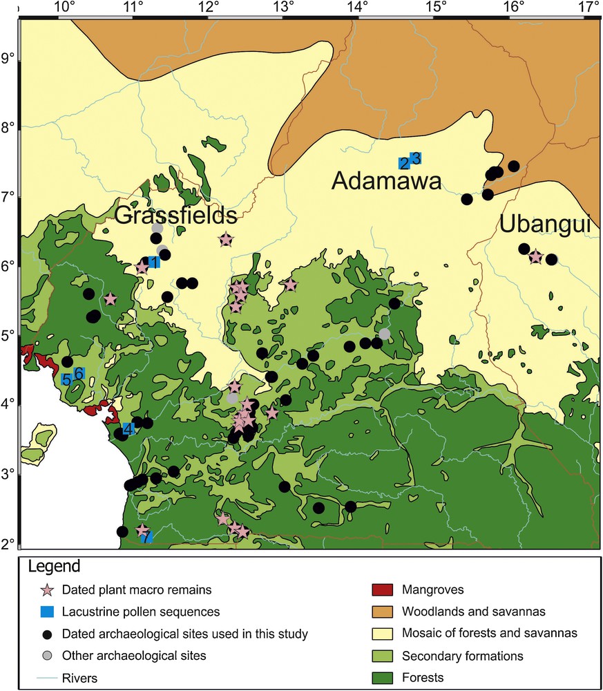
Distribution of archaeological, archaeobotanical and palynological data. Numbers refer to lacustrine pollen sites: (1) Lake Bambili; (2) Lake Mbalang; (3) Lake Tizong; (4) Lake Ossa; (5) Lake Barombi Mbo; (6) Lake Mboandong; (7) Nyabessam (see text for references).
Localisation des données archéologiques, archéobotaniques et palynologiques. Les nombres correspondent aux sites polliniques lacustres : (1) lac Bambili ; (2) lac Mbalang ; (3) lac Tizong ; (4) lac Ossa ; (5) lac Barombi Mbo ; (6) lac Mboandong ; (7) Nyabessam (les références correspondantes figurent dans le texte).
Vegetation map from Guillaumet et al. (2009)
3 Data and method
3.1 Pollen data
In this paper, we use new pollen series from the CVL region (Lake Bambili: Assi-Kaudjhis, 2011; Lézine et al., 2013) and the Adamawa plateau (Lakes Mbalang and Tizong: Lebamba et al., in prep; Vincens et al., 2010) from successive French Research Projects (ECOFIT, IFORA, C3A). These pollen sites provide high-resolution records (50 years resolution) of the last thousand years and the first pollen data from high and mid-altitude in central Africa. The vegetation history from these pollen sites is compared to already-published records from the lowlands at Lakes Barombi Mbo (Maley and Brenac, 1998), Mboandong (Richards, 1986), Ossa (Reynaud-Farrera et al., 1996) and at Nyabessam Swamp (Ngomanda et al., 2009). Only sites located north of the Equator are considered (Fig. 1).
3.2 Archaeological and plant remain data
Approximately 1000 archaeological sites are known in the study area (Essomba, 1998; Lavachery et al., 2010 and references therein). However, very few are dated. Our dataset includes only 107 localities with 351 dated samples (from 10,400 cal yr BP to the present) (Fig. 1). The oldest dates below the megalithic monuments from the CAR at 8400 cal yr BP resulting from preconstruction bushfire (Bayle des Hermens, 1975) have not been included in this study. Our archaeobotanical dataset includes 129 specimens from 10 plant species (Canarium schweinfurthii, Elaeis guineensis, Musa sp., Anthrocaryon micraster, Pennisetum glaucum, Sorgho, Ensete giletii, Vigna, Raphia, Coula edulis) recovered in the above-mentioned archaeological sites and known to be collected for human consumption or cultivated (Clist, 1989; Delneuf et al., 2003; Eggert et al., 2006; Kahlheber et al., 2009; Lavachery, 2001; Lavachery et al., 2010; Mbida et al., 2000; Mbida-Minzie et al., 2001; Neumann et al., 2012b; Oslisly et al., 2000; Zangato, 1995; 2000). This database is limited since it includes only dated samples and thus may underestimate the duration of human occupation at a given location. The large number of dates should however compensate for the heterogeneity of the dataset. Two hundred and fifty years is the interval that the uncertainties associated with the radiocarbon dates allow us to consider during the Holocene.
3.3 Chronological control
The dating control is based on AMS and conventional radiocarbon dates on charcoals, total organic matter, and charred plant remains. Raw 14C dates were converted into calendar ages using CALIB 6 (Stuiver and Reimer, 1993). Our analysis excludes archaeological data with uncertainties larger than ± 150 years and thus focuses on 288 dates only.
4 Results and discussion
4.1 Climate-driven versus anthropogenic environmental change
This part of the paper discusses the spatial and chronological distribution of the main variables taken into consideration, i.e. pollen data for vegetation and climate and archaeological sites for human occupation and their cohorts of food plants remains. The data are presented in three physiographic units: the Grassfield plateaus, the Adamawa and Ubangui plateaus and the low-lying zone of southern Cameroon.
4.2 The Grassfield plateaus
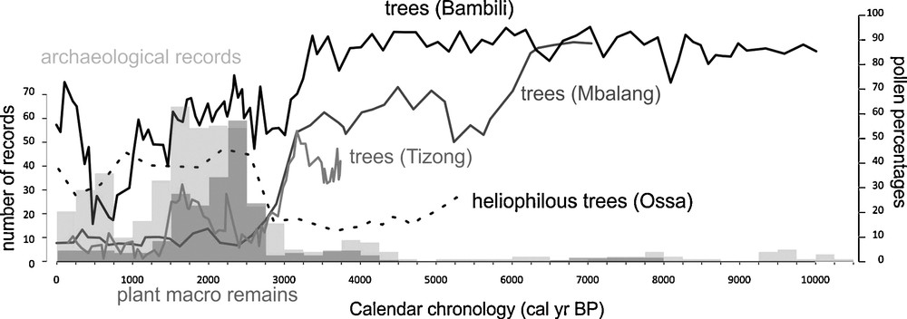
Pollen data from Lake Bambili at 2200 m asl show that the montane forest that expanded in the Grassfield plateaus underwent two main phases of contraction, from 3300 to 2700 cal yr BP, and 960 to 479 cal yr BP (Fig. 2). Both phases corresponded to a loss of about 40% of the pre-existing forest cover. An intermediate phase of forest recovery is observed between 2700 and 960 cal yr BP, punctuated by two severe and short (less than 100 years) events of forest degradation, respectively centred at 2600 and 1470 cal yr BP. The composition of the forest differs remarkably from one phase to another with the Holocene one before 3300 cal yr BP, dominated by afromontane elements (Podocarpus, Schefflera, Olea…) and the Late Holocene containing more heliophilous (Ilex mitis) and sub-montane, fast dispersing elements. During the last 500 years, the apparently most recent phase of forest increase is disproportionately lacking the diversity observed in earlier phases pointing to intense environmental disturbance (Lézine et al., 2013).
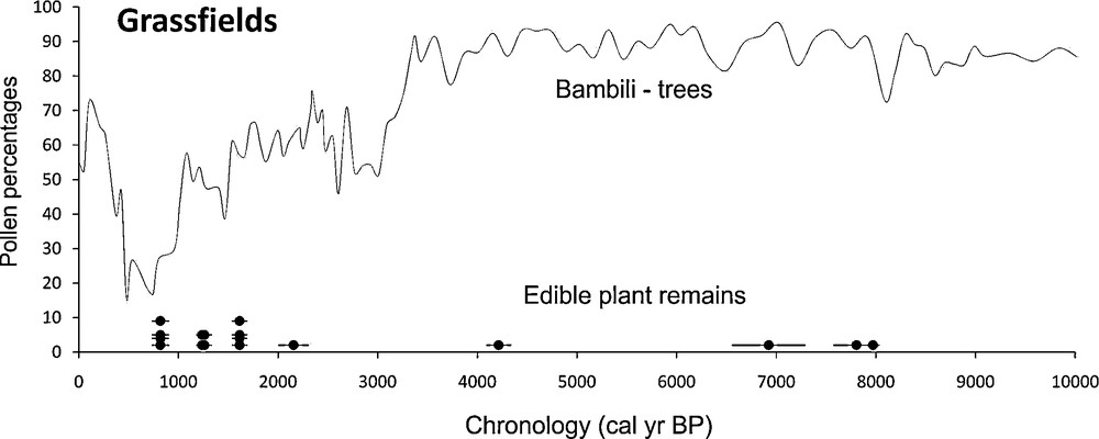
Arboreal Pollen profile from Bambili in the Grassfields. Dots show the radiocarbon measurements on edible plant remains.
Courbe des grains de pollen d’arbre à Bambili dans les Grassfields. Les points figurent les datations au radiocarbone effectuées sur les restes de plantes comestibles.
Archaeological sites are very rare in this region. With the exception of the Mbi Crater (Assombang, 1998) and Shum Laka (Lavachery, 2001) that date back to 35,000 years, the other sites are represented only by one (Abeke, Baleng, Bankouop, Fiye-Nkwi: Warnier, 1984) to a maximum of three (Fundong: Warnier, 1984) dated levels. All these archaeological sites are either rock-shelters or open-air localities with size ranging from 700 m2 (Mbi) to 7000 m2 (Fiye-Nkwi). Only Fundong, an open-air habitation site, has combined evidence of pottery and iron smelting (Warnier, 1984). Archaeobotanical information is only available at Shum Laka, where the Holocene sequence is well documented with 27 dated samples. This rock shelter, the best investigated site of the whole area, is located at 1600 m asl and measures 1200 m2, 82 m2 of which were excavated (Lavachery, 2001). The first phase of occupation dated from 10,300 to 8038 cal yr BP did not provide any plant macro-remains. The first occurrence of edible plant remains falls between the time interval 8038 cal yr BP–6557 cal yr BP and only concerns Canarium schweinfurthii. Another isolated remain of this species is dated from 4215 ± 125 cal yr BP. Then, it is only after 2155 ± 150 cal yr BP that one observes the diversification of the edible plants with 13 dated occurrences of Canarium schweinfurthii, Elaeis guineensis, Ensete giletii, Raphia sp. Elaeis guineensis, and Raphia sp., found exclusively in the last phase of occupation at 1617 and 819 cal yr BP, respectively. Canarium schweinfurthii is a large tree that grows in rain forest, gallery forest and transitional forest from 0 to 1000 m asl. Shum Laka is now situated above its upper ecological limit. The three other plant types are common in the Grassfields today and spontaneously grow in gallery forests (Elaeis, Raphia) and mid-altitude savannas (Ensete). Corresponding pollen grains have not been found at Bambili. Only few grains of Elaeis guineensis are present at Mbi, a nearby crater swamp at levels dated from 300 cal yr BP onward. This suggests that Canarium schweinfurthii, Elaeis guineensis, Ensete giletii, Raphia sp. neither dominated the regional landscape during the Holocene as natural populations, nor were widely cultivated in the Grassfields. The period of edible plant diversification at Shum Laka encompasses the second half of the secondary forest phase and occurs 1000 years after the first forest collapse. In the absence of extensive archaeobotanical analyses in the Grassfields, the examples given above suggest that the imprint of cultivation practices on forest cover was not significant during the Holocene until the last few centuries.
4.3 The Adamawa and Ubangui plateaus
Two pollen sites document the forest history of the Adamawa plateau (Vincens et al., 2010) (Fig. 3). They show a remarkable synchronicity in the forest collapse at 3000 cal yr BP. This result corroborates with previous studies from the Mbari Valley located eastward, in CAR, on the Ubangui plateau (Runge, 2002), which show a clear trend of savannization from that time onward. Owing to the location of this region, at the northern edge of the forest, the tree cover is thought to have been more sensitive to rainfall variability than in the Grassfields during the Holocene, with successive phases of more or less pronounced forest retreat punctuating the mid-Holocene: at 5700–5300 cal BP (Mbalang) and around 3500 cal BP (Tizong). The Late Holocene phase of forest recovery is centred at 1700 cal yr BP, spanning no more than 1000 years.

Arboreal pollen profiles from Mbalang and Tizong in the Adamawa plateau. The edible plant records come from the Ubangui area.
Courbe des grains de pollen d’arbre à Mbalang et Tizong dans l’Adamawa. Les restes de plantes comestibles proviennent de l’Oubangui.
The Adamawa plateau has been poorly investigated archaeologically so far with only eight sites (Bemboyo, Sokorta Manga, Djaoro Mbama, Beka Petel, Ewankang, Osokorto Manga, Pangar, Gbatoro) with and without evidence of iron smelting (Lavachery et al., 2010; Zangato and Holl, 2010). More sustained research carried out in the Ubangui plateau recorded some 103 archaeological sites, 38 of which with precise chronological frame from 190 radiocarbon-dated samples (Zangato, 2000, 2007). They include lithic workshops (nine sites), cemeteries (11 sites), large habitation sites (17), iron-smelting workshops (32), and megalithic sites (34). Settlement location is well patterned. Habitation sites and cemeteries, measuring 2 to 8 ha in extent, are located on the plateau, generally between 1000 and 1100 m asl. Lithic and iron-smelting workshops are generally located in valleys bottoms and megalithic monuments are located on the plateau's edge (Zangato, 2000). Archaeobotanical remains are scarce from only two archaeological sites from the Bouar area in the Ubangui plateaus, which yielded five occurrences of Canarium schweinfurthii and one occurrence of Elaeis guineensis. One occurrence of Poaceae, the assignation of which to Pennisetum is not certain, was also noted. All these plant remains were dated between 3800 and 2500 cal yr BP, i.e., starting 800 years before the main forest collapse at 3000 cal yr BP and continuing during the early subsequent phase of peak savannah extent.
4.4 The lowlands
The Late Holocene environmental changes in the lowlands from Cameroon are now well documented from several pollen sites from the western part of the country (Fig. 4). All these show the development, within the forest core, of light-demanding trees and/or the expansion of grasses starting from 2800–2500 cal yr BP at Ossa (Reynaud-Farrera et al., 1996) and Barombi Mbo (Lebamba et al., 2012; Maley and Brenac, 1998), two sites unfortunately studied at low time resolution, and from 2400 cal yr BP at Nyabessam (Ngomanda et al., 2009) and Mboandong (Richard, 1986). As a consequence of the better chronological frame of the two later sites, we consider the age of 2400 cal yr BP as the more probable for this major environmental event.
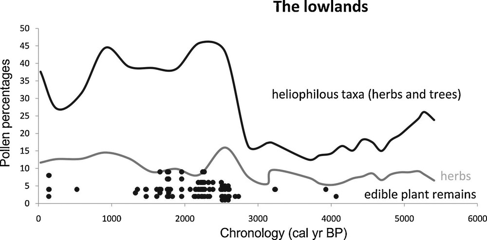
Arboreal pollen profiles from Lake Ossa in the lowlands of western Cameroon showing the expansion of heliophilous trees in the central African forest domain. This, together with the increase of grass populations, illustrates the opening of the forest core. The edible plant records come from the whole area covered by our study.
Courbe des grains de pollen d’arbre à Ossa dans les basses terres de l’Ouest Cameroun, montrant l’expansion des arbres héliophiles à l’intérieur du massif forestier central. Avec l’augmentation des herbes, ceci montre l’ouverture du massif forestier. Les restes de plantes comestibles proviennent de toute la région couverte par notre étude.
Archaeological sites from this part of the study area are distributed over an extensive territory that includes the Tikar plain, the drainage basins of the major rivers (Sanaga, Mbam, and Nyong), the Yaoundé and the coastal areas. The linear NE–SW arrangement of sites along the Sanaga River is mainly an artefact of the preventive archaeological program carried out during the construction of the Kome–Kribi Chad–Cameroon oil pipeline (Lavachery et al., 2010). Scattered occurrences of edible plant remains (Canarium schweinfurthii and Elaeis guineensis) are recorded only from two areas (the Yaoundé area and the Tikar plain) between 4000 and 3000 cal yr BP. They considerably increase and diversify between 2700 and 1300 cal yr BP all over the study area with Elaeis guineensis (38 occurrences), Canarium schweinfurthii (25), Anthrocaryon micraster (3), Musa (3), Raphia (4), Coula edulis (2), Vigna (6), and Pennisetum glaucum (8). The cultivation of the later in the central African forest domain is thought to have been favoured by the setting of suitable climatic conditions, including pronounced seasonality in rainfall with a distinct dry season (Ngomanda et al., 2009). There is no record of plant remains from 1300 to 524 cal yr BP and the last occurrences of Canarium schweinfurthii, Elaeis guineensis associated with Sorghum are dated to the last few centuries (Delneuf et al., 2003). The presence of Sorghum, characteristic of semi-arid regions, testifies for the very recent climate deterioration.
4.5 Regional distribution of human settlements during the Holocene
As far as the regional distribution of human population in central Atlantic Africa is concerned, the earliest dated sites are found in the CVL region (Mbi Crater and Shum Laka) (Fig. 5). Despite the predominant of Shum Laka sequence, the CVL region seems to have been inhabited more or less continuously throughout the Holocene. Hiatuses are not significant at this stage of research. The Adamawa and Ubangui plateaus are settled from 7500 cal yr BP intermittently. Human occupation in this area increased from 4500 cal yr BP onward and was interrupted around 3400 cal BP. It resumed around 3125 cal yr BP and fluctuated with peaks at 2875, 1625 and 625 cal yr BP. Interestingly, the two main 3400 and 1000 cal yr BP gaps are not represented in the CVL region. The human occupation of the lowlands is delayed (despite of episodic settlements centred at 9500, 6200, 4125) by 1500 years compared to the previous areas. The peak of human settlements occurs from 2500 to 1500 cal yr BP. Then, there is a sharp decrease in dated archaeological sites between 1500 and 750 cal BP.
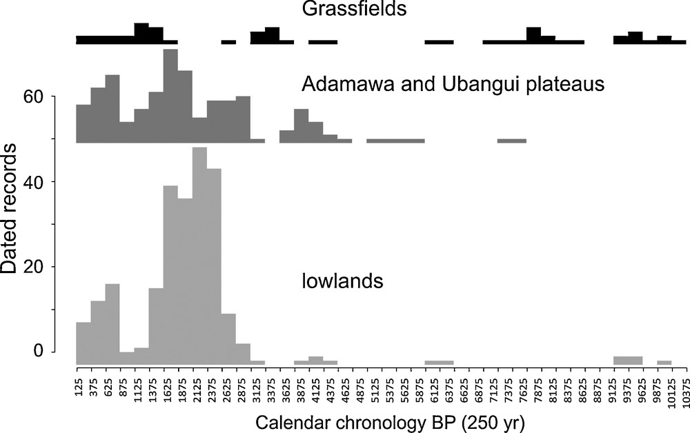
Frequency distribution of dated archaeological sites in the three physiographic units: the Grassfields plateaus, the Adamawa and Ubangui plateaus and the low-lying zone of Cameroon.
Répartition des données archéologiques datées dans les trois unités physiographiques : le plateau des Grassfields, l’Adamawa et l’Oubangui, les basses terres du Cameroun.
In summary, there is clearly a chronological gradient suggesting that human settlements spread from the west-northwest flank of the study area to the east, south, and southeast. From 4500 to 3000 BP, the number of settlements fluctuates between one and six in the first half of the Late Holocene. Four to five sites, Shum Laka rock shelter in the CVL region, the open-air site of Mouanko in the Atlantic flank of the lowlands, and the iron-working workshops of Oboui and Gbatoro, in the mid-altitude of the eastern Adamawa and the Ubangui plateau, were inhabited between 4500 and 4250 cal yr BP. The number of sites shifts from five in 4250–4000 cal yr BP, with the addition of Kong in the lowlands, to six in 4000–3750 cal yr BP, with settlements confined to mid-altitude to lowlands. Most of the sites from this period (Bouar, Oboui, Gbatoro, Bouboun-kpogbere, and Balimbe) are located in the mid-altitude zone of the eastern Adamawa and the Ubangui plateaus. There is a sustained decrease in the number of settlements from 3500 to 3000 cal yr BP, from four to one and three. In general, when data are available, the recorded settlements tend to be small in size, suggesting that humans were organized in small tightly knit entities spread out in small groups all over the study area. The pace of foundation of new settlements, their regional distribution and size change radically around 3000 cal yr BP. The number of settled localities shifts to 10 in mid-altitude and lowlands from 3000 to 2750 cal yr BP. Settlement size increased considerably with relatively large village sites on hill top, measuring 6 to 8 ha. The number of settlements, most located in mid-altitude and lowlands increased to 16 from 2750 to 2500 cal yr BP to be sustained with a peak at 25 and 18, respectively, from 500 to 250 and from 250 to 0 cal yr BP.
5 Conclusion
The interaction between environmental change and human settlements are complex webs of relationships. It includes the nature of the environment and of its components, the pattern of exploitation and selection of resources, the anthropization of the landscape.
Pollen profiles discussed in the paper clearly show that the last main environmental crisis was far from synchronous and took place successively at ca. 3300 cal yr BP in the Grassfields, ca. 3000 cal yr BP in the Adamawa–Ubangui plateaus and ca. 2400 cal yr BP in the lowlands. Even taking into account the error associated with the radiocarbon ages, there is a lag of about 1000 years between the high- and lowland environmental change (Fig. 6). In the later area, however, the rain forest core did not completely disappear, but changed its nature, and was made of a large proportion of light-demanding trees. This lag may be due to local hydrogeological factors or to a delayed response to environmental forcing. It thus suggests that the montane forest was much more sensitive to drop in rainfall than the low-lying forests.
Synthesis of Palaeoenvironmental and archaeological data used in this study, showing the lag between human settlements and environmental dynamics along the northwestern edge of the central African rain forest.
Synthèse des données paléoenvironnementales et archéologiques utilisées dans cette étude, montrant le décalage entre les dynamiques de peuplement et environnementales à la limite nord-ouest du massif forestier central en Afrique.
Archaeological sites clearly evidence a chronological gradient suggesting that human settlements spread from the west-northwest flank of the study area to the east, south, and southeast. The pace of these settlements is remarkably asynchronous to local environmental change within each area and seems to follow its own patterns. Before 4500 cal yr BP, both environmental and archaeological evidences are too few and scattered to discuss the impact of human populations on the natural landscape, which in any case seems to have not been significant (Fig. 7). Starting from 4500 cal yr BP, the human settlements increased in all part of the study area and peaked between 2500 and 1500 cal yr BP, i.e., well after the first significant episode of environmental degradation. On the contrary, the maximum of dated sites is coeval with a short reforestation episode in the Adamawa plateau and the Grassfields region. The number of dated archaeological sites shrunk from 1500 cal yr BP to 750 cal yr BP, as also observed southward in Gabon (Clist, 1989). This may be related to the environmental degradation all over the mid- and low-lying areas. Two hypotheses can be suggested:
- • this drop can be a genuine one resulting from the significant decrease in density of human population;
- • keeping the population constant, the decrease in the number of sites could also result from the aggradations of population in larger villages.
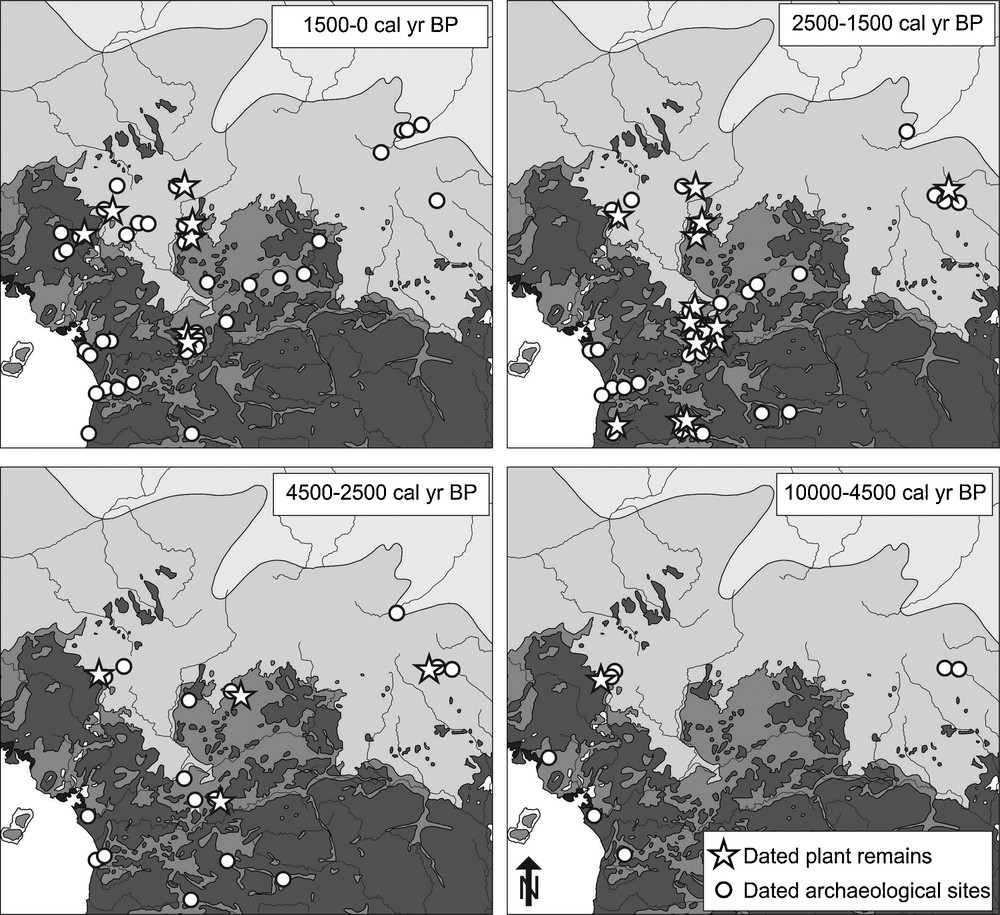
Distribution maps of dated archaeological and archaeobotanical records within four chronological sequences.
Répartition des données archéologiques et archéobotaniques au cours de quatre séquences chronologiques.
Available data do not permit to choose between these two hypotheses. From 750 cal yr BP onward, dated settlements increase again leading to the present-day situation.
Thanks to recent archaeobotanical research in southern Cameroon (Neumann et al., 2012b and references therein) the quantity of plant macro-remains has increased significantly. However, no evidence of tubers (wild and domesticated yams), which may have been the staple food of forest dwellers, has been found so far. The first evidence of exploitation of plants dates from 8000 cal yr BP and concerns the oily tree Canarium. Exploited plant considerably diversified after 4500 cal yr BP in the context of expanded human settlements in four main steps: Elaeis from 4150 cal yr BP (Obobogo: de Maret, 1992), Musa from 2700 cal yr BP (Nkang: de Marret, 1992), Pennisetum from 2500 cal yr BP (Bwambé Hill; Eggert et al., 2006) and Sorghum from 265 cal yr BP (Nditam Mosquée; Delneuf et al., 2003). The exploitation of Elaeis took place within the context of the fragmentation of the lowland rainforest. The cultivation of cereals (Pennisetum and Sorghum) was opportunistically initiated only in the low-lying areas during the dry phases at the end of the African Humid Period (Delneuf et al., 2003; Eggert et al., 2006).
In spite of our limited database, it can be suggested that sustained interactions took place between the three above-mentioned altitudinal ranges. First an expansion from the Grassfields to the Ubangui plateaus occurred at 4 ka BP. Then, from 2700 cal yr BP, a move from the Ubangui plateau to the lowlands and back to the Grassfields area followed.
Acknowledgements
This research was sponsored by the national funding agency in France (ANR) through two distinct projects: “IFORA”, coordinated by M. Veuille, and “C3A”, coordinated by A.-M. Lézine. We thank H. Chevillotte (IRD, France) who made the map available for this article. A.-M.L. and A.V. are supported by CNRS (France), A.F.C.H by Paris-Ouest University (France) and E.S. by MNHN (France). C.A.K, L.F. and J.L. were funded by the ANR.