

Version française abrégée
L'aquifère multicouche du Cénomano-Turonien et Sénonien du bassin synclinal de Meskala–Kourimat (Essaouira, Maroc) est contenu dans des formations carbonatées (calcaires marneux, calcaires dolomitiques et calcaires micritiques), fortement karstifiées, tantôt du Cénomanien sommital (C1b), tantôt du Turonien (C2), et tantôt dans les deux. Cet aquifère peut, par endroit, passer dans les formations marno-calcaires du Sénonien, particulièrement dans le synclinal de Meskala.
Cet aquifère représente l'unique ressource en eau potable pour les populations et leur cheptel dans toute la région de l'étude, en l'absence d'eau de surface pérenne, en raison de la rareté des précipitations et de l'aridité du climat [13–17].
Ces eaux souterraines montrent des indices évidents de contamination par les nitrates. Ceux-ci se retrouvent d'ailleurs dans les eaux de l'oued Qsob, exutoire naturel des écoulements souterrains, mais à des teneurs nettement plus faibles.
Les origines classiques des nitrates, en l'occurrence les pollutions industrielles, domestiques et agricoles (grande irrigation) sont quasi absentes de la région d'étude. De plus, le fond géochimique en azote dans la région est faible. L'origine d'une telle abondance en nitrates dans les eaux souterraines est donc problématique.
La distribution spatiale des teneurs en nitrates montre une plus forte abondance relative dans le périmètre de Kourimat, où une petite unité hydraulique est en train de se mettre en place depuis quelques années.
En 1996, une campagne de prélèvements pour analyses physico-chimiques, portant sur 80 puits et forages, a révélé l'existence quasi généralisée des nitrates dans les eaux souterraines. Leur concentration peut parfois dépasser les . La distribution des fréquences de ces analyses a montré que 58 % des échantillons avaient des taux de nitrates entre 0 et , 29 % entre 50 et et seulement 13 % des teneurs supérieures à . Cette pollution se retrouve dans les eaux de surface de l'oued Qsob, après un long chemin parcouru à travers les terrains aquifères.
En mars 2000, une quarantaine de points d'eau dont la teneur en nitrates dépassait (en 1996) a été revisitée et analysée, afin d'évaluer le comportement des éléments en solution, en particulier les nitrates. L'évolution des teneurs en ces points est assez faible et s'opère dans les deux sens, enrichissement et abattement.
Cette tendance s'est confirmée lors d'une dernière visite opérée en juillet 2000, qui a porté sur 13 points d'eau fortement minéralisés en nitrates.
Les sols, supports des cultures irriguées et des « bours » (non irrigués), faisant appel à d'intensifs amendements en fertilisants azotés, sont squelettiques, peu développés et directement en contact avec les formations karstiques qui contiennent l'aquifère du Cénomano-Turonien.
Les traits morphologiques d'une intense karstification bien évidente, aussi bien en surface qu'en profondeur, constituent des voies préférentielles de circulation d'eau et favorisent l'acheminement des nitrates vers les eaux souterraines à travers une zone non saturée plus ou moins épaisse, mais insuffisante pour provoquer un abattement de ceux-ci.
Parmi les origines possibles des nitrates dans les eaux souterraines figurent, entre autres et selon un degré d'importance décroissant, (1) les fertilisants azotés et la nature même du cycle de l'azote dans la zone non saturée, (2) les eaux usées domestiques, (3) les excréments du bétail autour des points d'abreuvement et (4) la proximité des ouvrages de captage de cimetières et la décomposition des dépouilles mortelles.
1 Introduction
Since the sixties, Morocco has implemented a self-supporting food policy programme that has resulted, among other things, in the intensification of agricultural practices in a large part of the country. In the same time, the area of irrigated zones has been increased, exploiting the surface water resources collected in a network of recently constructed reservoirs. The use of fertilisers was also intensified to increase the productivity of cereals and other crops. But this use of fertilisers was not based on clear norms, considering the specificity of the environment of the agricultural areas in Morocco.
The immediate consequence of this shift in agricultural practices is the increased risk of groundwater contamination by fertiliser residues. For example, in the Tadla irrigation zone (Tadla Plain, Central Morocco), the groundwater nitrate load has exceeded the limit, fixed by the WHO [32]. In some zones, this amount exceeds .
As surface waters are rare in Morocco, groundwater represents an important water resource, which needs to be carefully managed [13–17].
In this paper, we report on the nitrate contamination load, its spatial distribution and possible origins, of a non-irrigated area in the Essaouira Basin (Morocco). The largest part of the aquifer is situated in the fractured aquifer system of the Middle and Upper Cretaceous. In 1996, 80 wells and drillholes were sampled in the area, to determine the basic physicochemical quality of the groundwater. The ionic balance of all analyses was acceptable (under 10%) [29]. However, the analyses revealed a nitrate problem with observed concentrations in many cases exceeding . This unexpected result could not be attributed to the usual causes (agriculture, industry, and domestic pollution). Many authors have studied the nitrate problem with special attention to its origin and behaviour in groundwater [12,22,25]. In addition, the geochemical background did not explain the observed contamination. In order to obtain more details on the nitrate contamination and an explanation of the possible origins of this contamination, two additional series of samples were taken in March and July 2000. The analyses were carried out at 38 points where the previous measurements exceeded of nitrates.
2 Materials and methods
2.1 Geographical context
The study zone, called the synclinal basin of Meskala–Kourimat–Ida Ou Zemzem, is situated in the extreme North of the western High Atlas [1,2,18–20]. The basin is part of the Essaouira–Chichaoua Basin [11]. Locally, it is called the Atlantic Atlas [31]. The geological details of the area are given in Fig. 1.
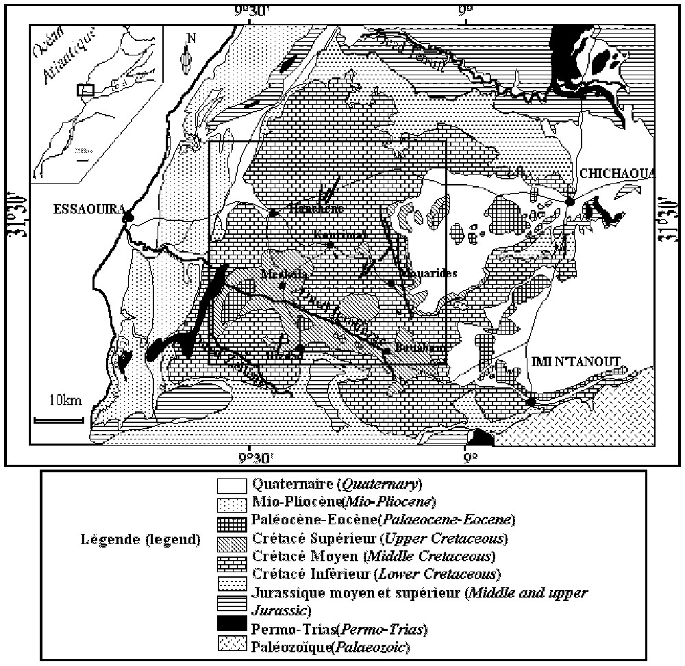
Location and geological configuration of the study area.
Situation et cadre géologique de la zone d'étude.
The climate in this area is in general semi-arid. The total rainfall does not exceed [21]. Precipitation is only significant between January and April. The seasonal temperature variability is high, with a mean winter temperature of 11 °C and a mean summer temperature of 25 °C [21].
In the region, there are only a few small villages of some hundreds of inhabitants, such as Meskala, Kourimat, Mouaride, Ounagha, etc. The liquid waste (waste water, sewage water) from these small communities is handled on an individual basis by a system of waste tanks, installed in fractured rocks. Dimensions and geometry of these septic pits differ and do not comply with any norm. They are porous. Thus, the organic sewage of domestic wastewater, able to be nitrified as much as livestock excrements go downward through the network of fractures to the watertable. However, no exact data about population and about the number of septic tanks is available, only a rough estimate is possible to approach the nitrate flux coming form this process (see Table 2).
Amount on nitrogen production by the population and the livestock (source: DPA Essaouira, 2002)
Production d'azote par la population et le cheptel de la région (source: DPA Essaouira, 2002)
| Origin | Population size | Daily production per capita | Total equivalent nitrates | Global annual nitrates production |
| (tons NO3) | ||||
| Total population: | ||||
| Inhabitants | 17 495 | 15 | 262 425 | 425 |
| Small animals: | ||||
| Sheep and goats | ||||
| population | 40 470 | 27 | 1 092 690 | 1770 |
| Big animals: | ||||
| Bovine and camel | ||||
| population | 4270 | 195 | 832 650 | 1345 |
| Total | 3540 |
2.2 Geological and hydrogeological context
The oldest geological formations are the limestone and dolomites of the Upper Albian (Vraconian), while the youngest are the detrital deposits of the Plio-Quaternary (Fig. 1). The most common outcrops from the Middle and Upper Cretaceous are the Cenomanian and the Turonian formations, covered by the Senonian [27].
The Cenomanian is subdivided in two non-homogeneous layers: (1) the basal Cenomanian (C1a) formed by marls and calcareous marls, with a very low permeability and a thickness of about 200 m and (2) the Upper Cenomanian (C1b) formed by marly limestone and yellow limestone, highly fractured and also about 200-m thick.
The Turonian (C2) is relatively more homogeneous than the Cenomanian, and is represented by beige limestone and dolomite limestone, with detritus of flint and yellow marly limestone. It is fractured and karstic with a mean thickness of about 50 m.
In view of its geologic and fracture properties, the Cenomanian, Turonian and Senonian layers should be considered as a multi-layer aquifer with a ‘fracture permeability’ [8,9,26]. The water flow and transport occur in the fractured network and in the stratification joints. The aquifer is bounded by the very poorly permeable basal Cenomanian at the bottom and confined in some places at the top by the Senonian marl. If this layer is missing, the aquifer is unconfined.
The aquifer transmissivities vary between 10−4 and , while its specific yield varies between 10−4 and 10−2 [21,23].
The physical and chemical quality of the groundwater is relatively good. The most common chemical facies of the water are bicarbonated calcic and bicarbonated magnesian with a tendency to sodic facies [21,23]. The salt content is sometimes high and can reach when the lithologic conditions favour the contact with the gypseous marl of the basal Cenomanian or of the Senonian formations.
2.3 Samplings
The number of samples analysed in the first series (1996) was about 80. Those analysed during the second and the third samplings in 2000 were about 40 and 13, respectively. Only wells and drillholes showing a nitrate content exceeding were concerned by the second and third samplings.
3 Results and discussion
3.1 Extent of the nitrate pollution plume
In the 1996 samplings, the nitrate concentration in the observation wells varied between 0.6 and . Table 1 and Fig. 2 show the nitrate frequency distribution (with a step of ) of the analysed samples.
Frequency distribution of nitrate concentrations
Distribution des fréquences des nitrates
| Class | 1996 Campaign | March 2000 Campaign | July 2000 Campaign | ||||||
| () | Number | Percentage | Cumulative | Number | Percentage | Cumulative | Number | Percentage | Cumulative |
| (%) | (%) | (%) | (%) | (%) | (%) | ||||
| [0–50] | 46 | 57.50 | 57.50 | 9 | 23.08 | 23.08 | 1 | 9.1 | 9.1 |
| [50–100] | 23 | 28.75 | 86.75 | 19 | 48.72 | 71.79 | 8 | 72.7 | 81.8 |
| [100–150] | 4 | 05.00 | 91.25 | 4 | 10.26 | 82.05 | 2 | 18.2 | 100 |
| [150–200] | 4 | 05.00 | 96.25 | 4 | 10.26 | 92.31 | 0 | 0.0 | 100 |
| [200–250] | 1 | 01.25 | 97.50 | 0 | 0.00 | 92.31 | |||
| [250–300] | 0 | 00.00 | 97.50 | 1 | 2.56 | 94.87 | |||
| [300–350] | 1 | 01.25 | 98.75 | 1 | 2.56 | 97.44 | |||
| [350–400] | 0 | 00.00 | 98.75 | 1 | 2.56 | 100.00 | |||
| [400–450] | 1 | 01.25 | 100.00 | 0 | 0.00 | 100.00 | |||
| Total | 80 | 100% | – | 39 | 100% | – | 11 | 100% | – |
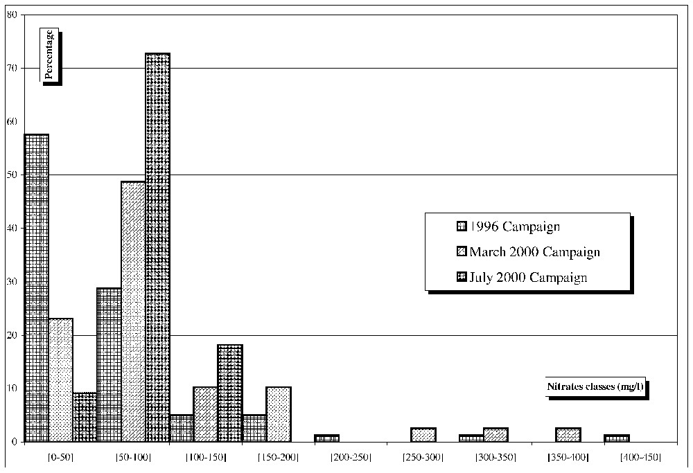
Nitrate frequency distribution for the three samplings.
Distribution des fréquences des nitrates (% simple et cumulés).
Table 1 shows that most of the 1996 samples are situated in the [0–] class, followed by the [50–] class. These two classes represent 87% of the total samples. Although 13% of the samples have concentrations higher than , they must be considered very carefully. On the other hand, more samples from the 2000 survey are situated in the [50–] class, which now becomes the largest one. The first two classes now represent 72% of all samples. It should however be noted that the sampling of 2000 is biased because of the exclusion of all the points where the nitrate content was lower than in the 1996 survey.
The nitrate concentrations in the repeated samples varied during the period 1996–2000. They decreased in 27 wells, by a value ranging from 1.42 to , while they increased in 12 wells by a value ranging from 1.10 to . Well No. 827/52 showed the highest reduction of approximately .
During the second survey, the climate was characterized by exceptionally low amounts of rain during the first six months of the hydrological year 1999–2000, which jeopardized agriculture. Hence, no nitrate fertilisers were spread during this period.
The observed increase must therefore be explained by a mixing of groundwater with an existing nitrate pollution plume. Given the karstic nature of the aquifers, the probable existence of a nitrate pollution plume may affect a great part of the study region, and may be a serious concern for the rural population. In fact, groundwater is the only drinking water resource in this area, and special attention must be given to health risks associated with nitrates in drinking water.
In order to determine the extent of the nitrate pollution plume, a spatial approach was adopted by mapping the spatial distribution of nitrates concentrations. Fig. 3 shows that the highest concentrations are observed close to the Kourimat zone (coordinates x=117, y=102 in Fig. 3). The spatial pattern is not coherent with the expected movement of the groundwater, which is imposed by a hydraulic gradient oriented north and northwest (Fig. 4).

Spatial distribution of the nitrate in the aquifer region.
Répartition spatiale des nitrates () dans la région d'étude.
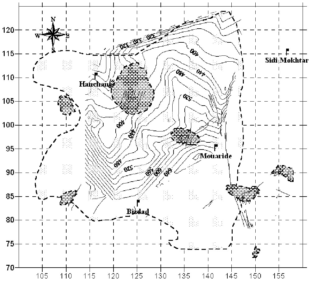
Piezometric map of the studied area.
Esquisse piézométrique de la région d'étude.
Nitrates were also observed in the water of the Igrounzar and Zeltene Rivers, which form the natural outlet of the aquifer system. Fig. 5 presents the nitrate evolution in surface water since 1991. It shows nitrate concentration of around 10 to and exceptionally reaching . In general, the amount of nitrates in the surface water is lower than in the groundwater. The Igrounzar River shows higher nitrates contents than the Zeltene River. This can be explained by the fact that the Zeltene Basin is located further south in a topographically varied land, where intensive agriculture is less developed than in the Igrounzar Basin. The lower nitrate content in the surface water indicates that aquifer and vadose zone properties play an important role in the dispersion of the nitrate pollution plume, and strongly affect the mixing of the nitrate into the groundwater and the dilution process. In addition, we can consider that along the rivers, the abundant vegetation (reeds, trees, cultivated terraces) ‘consume’ and export a part of the nitrates [12] coming from groundwater. Denitrification could also occur.
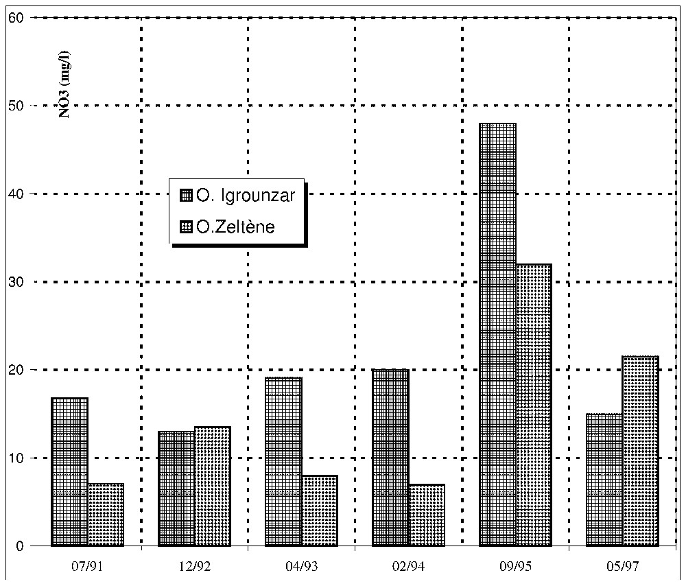
Evolution of the nitrate concentrations in the surface water.
Évolution dans le temps de la concentration en nitrates dans les eaux de surface.
3.2 Origin of the nitrate contamination
3.2.1 Fertilisers
There is no detailed information about the amount of fertilisers used by farmers in the region. However, it is estimated that the mean N amounts applied are 150 to , commonly in the form of a NPK fertiliser (14% of N, 28% of P and 14% of K). Given that the total surface area of the region is 750 km2 (or 75 000 ha) and that it receives a yearly recharge of 35 to 50 mm, this will correspond to a yearly volume of recharge water of 2.7×10⁷ m3 to 3.75×10⁷ m3 for the total area. If for example 500 to 1000 tons of nitrates reach every year the watertable (assuming a leaching rate of 6 to 13 kg NO3, or 1.5 to , over an area of 75 000 ha), this would give a mean nitrate concentration of approximately 20 to in the recharge water, if the contamination was uniformly distributed. If during several tens of years, this aquifer was recharged with water of this concentration and that there was no denitrification, then the mean concentration in the aquifer would eventually tend toward this value. Given the small amount of nitrates likely to be taken up by plants in the arid conditions of the area, the amount of nitrate that can be leached each year is likely to be higher. But the total area of the basin does not receive 150 to .
The Cenomanian and Turonian formations represent 68% of the outcrop of the study area [28]. These formations are karstic in nature, and have thin soils developed as a result of physicochemical alterations of carbonate rocks [3–5,7]. These thin soils are in direct contact with the karstic aquifer and fertilisers are transmitted directly to the groundwater through the unsaturated zone [6,10,24,30].
In addition to fertilisers leached from classical agricultural practices, the impact of irrigation should be taken into account. The local agricultural authority started prospecting groundwater resources from 1978 onwards, expecting the irrigation of 300 ha. The work is at present in the planning and experimental stage. Local farmers, however, in search of better management practices, participated in a development experiment and applied 150 to . Application of large amounts of fertilizer to irrigated fields is known to create problems in terms of nitrate leaching.
3.2.2 Livestock excrements
Groundwater has been the only drinking water resource for both human population of the area and for livestock for over a hundred years. Animals come to drink water in the vicinity of the wells, which generally are not protected. In this case a risk exists that livestock excrements, concentrated in easily decomposable N materials will rapidly mineralize into mobile nitrate, which in turn will reach the groundwater through the unsaturated zone. The time spent between the soil surface and the watertable is short, because of the dense network of fractures in the aquifer rocks. Indeed, wells used to water livestock, such as the one called the Sebt Kourimat well, present the highest nitrate concentration. The watertable in this case is at a depth of no more than 2 to 3 m. Unfortunately, the number of livestock that drinks in the different points of water is not known exactly and varies from year to year according to climatic conditions. Therefore, it is difficult to quantify with precision the nitrate sewage coming from livestock excrements. We tried however to approximately calculate the amount of nitrate produced by livestock in the area, using the French ratios of nitrate production per capita, see Table 2, which also considers human waste water.
This total value, reported to a volume of recharge water of about 2.7×10⁷ to 3.75×10⁷ m3, should give a long-term mean concentration of 95 to of nitrates.
3.2.3 Muslim cemeteries and religious uses
Wells near cemeteries ensures Muslims of finding water for their rituals such as post mortem ablutions and religious preparing of the mortal remains. These rituals do not present any danger to groundwater but the decomposition of the organic debris results in a potential N pool.
4 Conclusion
This study reports the dispersion and possible origins of a nitrate contamination plume in a Moroccan karstic aquifer. The area is characterized by an intensification of the agriculture, which is associated with more intensive fertilisers use. The small thin soils in the area, together with the karstic nature of the geologic formations, result in rapid transport of large amounts of residual nitrates in the underground. Given the crop productivity, it is not expected that plant assimilation will balance the fertiliser application. Leaching is therefore expected to occur.
The nitrate concentration is lower in the surface water than in the groundwater. This illustrates the impact of dispersion on the mixing of nitrates in groundwater, and the associated dilution process, or else the consumption of nitrates by plants or denitrification in the alluvial aquifers.
The following processes contribute to the nitrate load in the Meskala–Kourimat–Ida Ou Zemzem Basin: (i) diffuse pollution from fertilization practices on thin soils that are in direct contact with karstic formations; (ii) local contamination by human wastewater; (iii) local contamination by livestock excrements around wells used to water animals aggravated by the absence proper protection of the wells and (iv) accidental contamination from the decomposition of mortal remains caused by the proximity of the wells to Muslim cemeteries.
The contamination is further promoted by the thickness of the unsaturated zone, especially in the Kourimat perimeter and by the high permeability of the karstic aquifer system.