

Version française abrégée
1 Introduction
Les modèles de sédimentation proposés [1,5] pour l'édifice Pyrénéo-Languedocien, golfe du Lion (Figs. 1 et 2) insistent sur une architecture sédimentaire régie essentiellement par les cycles glacio-eustatiques et la dynamique sédimentaire locale. Dans notre étude, au contraire, sont intégrées l'interprétation structurale et la stratigraphie sismique, afin d'évaluer comment la tectonique salifère peut influencer la configuration de systèmes de transport sédimentaire et l'organisation interne de l'appareil sous-marin Pyrénéo-Languedocien. Nous analysons l'interaction entre des facteurs externes, tels que la source des apports sédimentaires, avec des facteurs qui agissent localement ou régionalement dans le bassin, en l'occurrence la fracturation de la couverture sédimentaire et les mouvements verticaux des blocs consécutifs aux déformations salifères. Nos résultats montrent que, du point de vue structural, les déformations salifères dans le secteur sont très importantes et conduisent à un contrôle tectono-sédimentaire à l'échelle plus large du dépocentre de l'édifice sous-marin Pyrénéo-Languedocien [4]. Celui-ci correspond en réalité, pour nous, à un éventail sédimentaire construit au pied d'un talus dans une dépression due à la tectonique salifère. Notre étude est basée sur des résultats de sismique réflexion multitrace et sur de forages pétroliers (puits de forage GLP1, GLP2 et Autan) ; elle est réalisée dans le cadre du GDR « Marges golfe du Lion ».
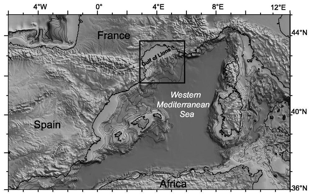
Regional map of the western Mediterranean Sea (after GTOPO3O data [12]).
Carte régionale de la Méditerranée occidentale (d'après les données GTOPO3O [12]).

Location map of the study area, showing the deep-water depositional systems offshore Gulf of Lions.
Carte de localisation de la zone d'étude, illustrant les systèmes sédimentaires profonds au large du golfe du Lion.
2 L'édifice sédimentaire sous-marin Pyrénéo-Languedocien
L'édifice sédimentaire Pyrénéo-Languedocien se met en place au large de la marge du Languedoc-Roussillon, dans le secteur ouest du Golfe du Lion (Fig. 3). Cette accumulation sédimentaire correspond à un surépaississement très important, où les sédiments peuvent atteindre 1000 m d'épaisseur [4]. L'édifice révèle une construction sédimentaire qu'illustrent des faciès sismiques de vagues sédimentaires (sediment waves) et une morphologie dissymétrique (Fig. 4). Ceci suggère des levées de débordement à partir de la vallée du canyon de Sète qui longe l'édifice à l'est (Figs. 3 et 4). Les caractéristiques morpho-sédimentaires ont amené des auteurs [1,5] à baptiser l'accumulation sédimentaire « ride Pyrénéo-Languedocienne », par analogie avec les rides comme celles du Var et de Marseille, localisées plus à l'est. Ils évoquent ainsi la construction préférentielle d'une ride sur le versant droit de la vallée du canyon de Sète.
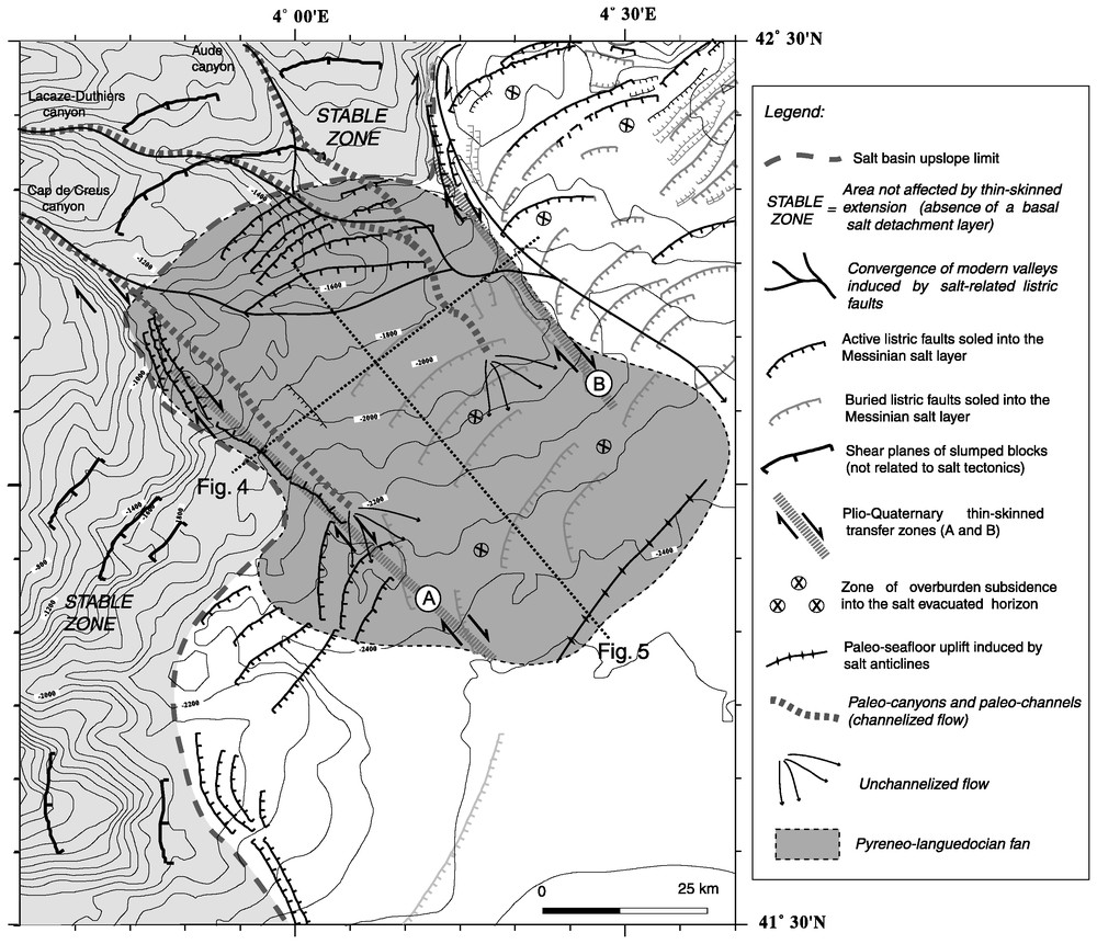
Salt-structural and sedimentary map of the Pyreneo-Languedocian fan area, illustrating the fan feeder system and major salt-related structures. The generation of the Pyreneo-Languedocian fan depocenter at slope level is intimately related to salt-tectonic processes that operate in the area. Pliocene overburden subsidence into the evacuated salt-horizon provided space accommodation for Quaternary clastic sediments (the Pyreneo-Languedocian fan).
Carte des structures sédimentaires et des failles générées par la tectonique salifère dans le domaine de l'éventail Pyrénéo-Languedocien. La figure illustre les systèmes d'alimentation de cette accumulation sédimentaire et les structures majeures induites par la tectonique salifère. La position du dépocentre est directement en relation avec le style structural dominant de la tectonique salifère. La subsidence des blocs pendant le Pliocène a pour effet la création d'un espace d'accommodation pour les sédiment quaternaires (l'éventail Pyrénéo-Languedocien).
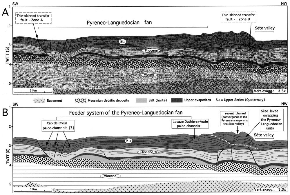
A. Interpreted seismic section across the Pyreneo-Languedocian submarine fan. B. Line drawing showing distinct depositional features related to sediment funnelling by the Pyrenean canyons and the Sète canyon. Location in Fig. 3.
A. Profil sismique interprété à travers l'éventail sous-marin Pyrénéo-Languedocien. B. Schéma montrant les figures sédimentaires en relation avec les sédiments chenalisés par les canyons pyrénéens et le canyon de Sète. Localisation sur la Fig. 3.
Nous observons, cependant, que les dépôts associés au canyon de Sète se mettent en place, créant des levées perchées sur la bordure est de l'édifice Pyrénéo-Languedocien. Cette superposition, sous forme de bourrelet longeant la rive droite du canyon de Sète, est responsable de la dissymétrie qui marque la géométrie externe de l'accumulation sédimentaire, exprimée par la bathymétrie actuelle (Figs. 3 et 4b). En réalité, les profils de sismique réflexion montrent que les principaux apports de sédiments de ladite « ride » proviennent des canyons en amont de la marge (les canyons de Cap Creus, Lacaze-Duthiers, de l'Aude et de l'Hérault) et s'étalent sous forme de lobes en bas de pente (Figs. 2 et 3). Ainsi, même si l'incidence d'un processus hydrodynamique de courants profonds qui façonne ce champ de vagues sédimentaires est évident, il nous semble inadéquat de le classer comme analogue aux édifices turbiditiques construits préférentiellement sur les versants droits de vallées sous-marines. La désignation de fan précédemment proposée par Got et Stanley [7] nous semble plus appropriée.
3 La tectonique salifère dans le domaine sous-marin Pyrénéo-Languedocien
La zone d'étude est localisée dans la province extensive de la tectonique salifère au large de la marge du Languedoc-Roussillon [4]. Ce domaine correspond à un changement de direction de la marge du golfe de Lion, qui prend une orientation nord–sud (Fig. 2). Les failles listriques synthétiques dominent largement dans la zone et affectent une bande située en pied de marge. Ces failles sont groupées notamment dans une famille proximale de direction générale NE–SW. Vers le large, l'espacement entre les failles les plus distales est de 4 à 10 km, pour atteindre 5 km en pied de talus. Parmi toutes ces failles, seul le réseau de failles proximales se propage jusqu'en surface (Fig. 3) et son expression est visible sur les cartes morpho-bathymétriques.
Le domaine sous-marin Pyrénéo-Languedocien est également caractérisé par un ensemble de failles de direction perpendiculaire à la marge (direction NW–SE). Une zone de failles transverses, visible sur la bathymétrie, est active jusqu'à l'Actuel. Elle est continue sur 40 km environ et se localise le long de la limite latérale du sel (le biseau de sel) (zone A sur la Fig. 4a). À l'est du domaine, une autre zone de failles transverses, moins continue, mais également de direction générale NW–SE, s'enracine le long d'une discontinuité du substratum salifère, à l'aplomb d'une zone de transfert du socle, la zone de transfert Rascasse [4,8]. Le jeu de ces failles est restreint au Pliocène et limite un compartiment légèrement basculé (zone B sur la Fig. 4a). La configuration géométrique de failles transverses plio-quaternaires (direction et profil raide) suggère un jeu en décrochement. Nous estimons que ces zones d'accident ont valeur de zone de failles de transfert superficiel (thin-skinned transfer zone) et que leur développement serait conditionné par le fonctionnement des contraintes locales du glissement gravitaire. Les failles, jouant en décrochement, semblent favoriser un mécanisme de fluage du sel latéralement contraint dans le secteur : le sel flue des zones hautes vers les zones basses, dans une direction préférentielle talus-bassin, selon un mécanisme dénommé pure salt flow par Nelson [9]. Ce mécanisme est proposé comme un type de glissement gravitaire associé à une morphologie contraignante du substratum mécanique du niveau ductile.
4 Le rôle de la tectonique salifère dans l'architecture de l'édifice sédimentaire sous-marin Pyrénéo-Languedocien
Le domaine sous-marin Pyrénéo-Languedocien se marque par une subsidence généralisée des blocs faillés dans le secteur moyen du système de failles [4] (Fig. 5). Le fluage et l'entassement de la masse de sel en aval du système sont accompagnés par la subsidence de compartiments de failles en pied de marge. L'entassement de la masse en aval du système salifère entraı̂ne un bourrelet de coussins de sel (sous forme d'anticlinal) et, par conséquent, un soulèvement des compartiments distaux par une déformation positive du relief. Les effets conjugués de subsidence généralisée des blocs et du soulèvement du relief des compartiments distaux amènent la formation d'une cuvette qui est à l'origine de l'espace d'accommodation sédimentaire des apports chenalisés vers ce site (Fig. 5). Ce cadre structural détermine donc le piégeage forcé de l'ensemble des arrivées turbiditiques, dans un bassin généré par la tectonique extensive superficielle. Ceci pourrait expliquer, par ailleurs, le fait qu'en amont de la zone, les canyons pyrénéens présentent d'épaisses levées et des traits de surcreusement, tandis qu'immédiatement en aval, ces traits ont complètement disparu et sont remplacés par des faciès sismiques lités sans traces de chenalisation (dépôt en sheet flow).
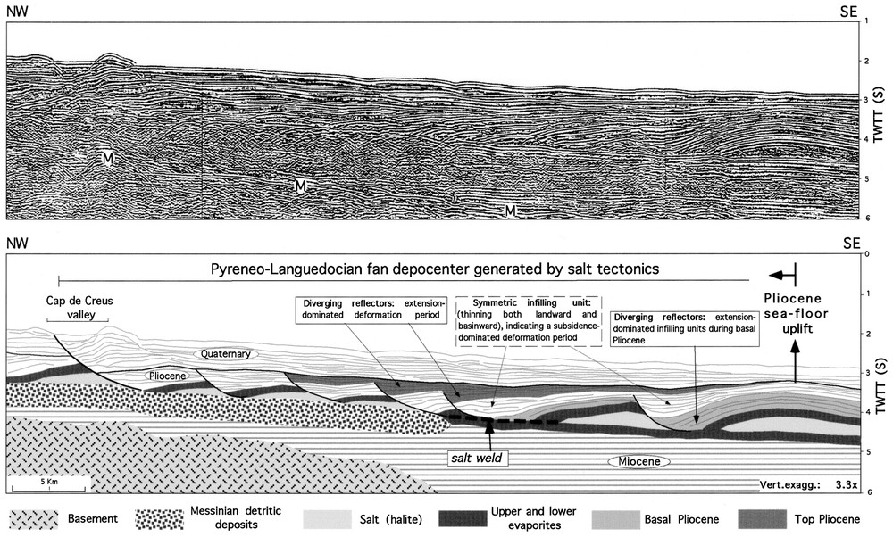
Uninterpreted deep seismic section (top) across the Pyreneo-Languedocian sub-basin Domain (LISA Cruise seismic survey) and detailed line drawing (bottom) illustrating the main deformational phases involved in the generation of the slope sub-basin. Location in Fig. 3.
Profil sismique à travers le domaine du sous-bassin Pyrénéo-Languedocien (profil de la campagne LISA) et schéma détaillé illustrant les principales phases de déformation à l'origine du sous-bassin. Localisation sur la Fig. 3.
5 Conclusions
D'après nos résultats, la structuration salifère et la sédimentation sont des processus étroitement associés dans l'évolution sédimentaire du domaine sous-marin Pyrénéo-Languedocien. Le cadre structural plioquaternaire de la région est illustré par la fracturation accompagnée par la subsidence par fluage du sel de la couverture sédimentaire. Les implications tectono-sédimentaires de cette structuration sont réalisées à l'échelle de dépocentre. La subsidence de blocs est responsable de la création d'un espace d'accommodation sédimentaire en pied de talus, et donc de la localisation plus proximale de cet édifice sédimentaire (à proximité des sources d'alimentation) par rapport aux autres édifices détritiques du glacis continental du golfe du Lion.
Ce dispositif se distingue ainsi des édifices tels que les rides de Marseille/Planier et du Grand Rhône, où l'empreinte de la tectonique salifère sur l'organisation sédimentaire s'illustre par des dépocentres confinés et allongés, toujours exprimés par la bathymétrie actuelle. En revanche, la géométrie externe arquée en pied de pente du fan Pyrénéo-Languedocien nous renseigne peu sur l'intervention et l'évolution locale de la tectonique salifère, pourtant déterminante dans l'édification de ce système sédimentaire.
1 Introduction
The Pyreneo-Languedocian sedimentary complex, located between the La Fonera and Sète valleys on the western Languedoc-Roussillon margin (Gulf of Lions, western Mediterranean Sea, Figs. 1 and 2), is a lobate sediment accumulation that spreads over the extensional zone of the sedimentary gravity gliding system. Proposed depositional models are largely based on seismic stratigraphy that emphasizes the role of glacio-eustatic fluctuations and overbanking sea-valley sedimentation as the major controlling factors of the stratigraphic architecture of the Pyreneo-Languedocian sedimentary complex [1,5]. Although salt tectonics has long been recognized in the area, none of the above-mentioned studies have focused on salt–sediment interactions and their implications for the sedimentary complex growth patterns. Our study discusses the impact of salt deformation on the Quaternary stratigraphic architecture of the Pyreneo-Languedocian sedimentary complex, pointing to a rather distinct evolutionary scenario, whose deposition and depocenter location seem to have been essentially controlled by salt tectonics.
Our study is based on closely spaced multifold seismic reflection profiles. Chronostratigraphy is controlled by three oil-exploration wells (Autan, GLP2 and GLP1).
2 The Pyreneo-Languedocian submarine sedimentary complex
The Pyreneo-Languedocian sediment accumulation, up to 1000 m thick, lies within an isolated salt-tectonic setting called the Pyreneo-Languedocian Sub-basin Domain (Fig. 4). Recent seismic investigation of this sediment body (CALMAR Mission, 1997) revealed successive layers displaying regular undulating parallel and continuous reflectors [1]. The depositional model proposed for this complex is quite controversial. Berné et al. [1] and Droz et al. [5] interpret this sedimentary feature as a sedimentary ridge similar to the Var Sedimentary Ridge located further to the east, along the Provençal margin. The wavy acoustic facies, consistent with sediment wave bedforms, was interpreted as the result of overflow of turbidity currents funneled by the Sète canyon-valley system. The observed sediment body asymmetry would then be due to preferential deposition of turbidity currents over the western flank of the Sète valley, due to Coriolis forces and/or counterclockwise circulation of the Liguro-Provençal geostrophic currents flowing along the margin [1] (Figs. 3 and 4). However, the Sète canyon does not appear to be an important feeder system nourishing this sediment accumulation [4]. Seismic sections across the Sète valley clearly indicate that reflectors at the base of its western levee onlap the Pyreneo-Languedocian sedimentary complex. The Sète levee deposit, prevailing all along the valley, systematically onlaps the eastern border of the sedimentary complex. This spatial arrangement turned out in apparent depositional continuity between the Sète levee and the Pyreneo-Languedocian complex (Fig. 4).
The apparent continuity between the Sète levee and the Pyreneo-Languedocian complex which seems to indicate a single large levee thinning westerly from the Sète valley axis, is misleading in terms of the deposition model involved. We favor a fan-like depositional model for the Pyreneo-Languedocian submarine complex, considered to have been fed by the Pyrenean canyons (Figs. 2 and 3). These canyons lie directly upslope from the sediment accumulation, exhibiting features that indicate recent transport. Upslope the salt province, recently conducted swath-bathymetric mapping has revealed modern narrow inner valley incisions, notably along the Lacaze-Duthiers and the Cap de Creus canyons [1]. Seismic sections across the intercanyon regions also have revealed shifting of High Amplitude Reflectors (HAR) that can be interpreted as systematic valley migrations and polyphased constructional activity [1,4]. Downslope, within the extensional zone, cross sections show flat-floored valleys that testify to a predominantly depositional environment. Seismic sections also show asymmetric acoustic units characterized by interbedded subparallel reflections, suggesting thick overflow levee deposition. Immediately basinwards, traces of channel-levee deposits are not at all observed and a wavy acoustic facies is thoroughly prevalent. The combined observation of systematic valley migration and thick levee acoustic facies indicates the relevance of the Pyrenean canyons as active sediment conveyors to the adjacent basin, thus favoring the assumption that these canyons are the main feeders for the sedimentary accumulation located downslope. Furthermore, the significant change in the seismic facies, from identifiable upslope channel-levee systems to downslope parallel reflectors, is interpreted to reflect the change from channelized to sheetlike deposition. This variation in seismic facies has led to the conclusion that the Pyreneo-Languedocian sediment accumulation is a submarine fan [7]. However, it is not a typical submarine fan, since at slope level, where upper and middle fan features should develop, it is composed of continuous parallel acoustic facies. This abrupt downdip facies variation is a direct result of a strong structural salt-tectonic control (see section below).
Stratigraphic correlations show that fan deposition is synchronous with the Rhone fan Upper Series deposition. Thus, its age is estimated to be Middle to Upper Pleistocene.
3 Salt tectonics within the Pyreneo-Languedocian submarine domain
Plio-Quaternary salt-structural evolution of the Gulf of Lions was primarily controlled by gravity gliding-spreading over a Messinian salt detachment. Thin-skinned extension produced three main tectono-stratigraphic provinces [4,6], as identified on passive margin basins (e.g., [2,3,10,11]): an uppermost Listric Fault Province, an intermediate Rigid Gliding Province and a lowermost Salt Dome Province. The Listric Fault Province is dominated by basinward-dipping faults and expanded stratigraphic wedges. Fault strike is dominantly parallel to subparallel to the shelf break. Downslope, the Rigid Gliding Province is characterized by a rather tabular salt layer, and the overlying sediments remain parallel to the top of the salt. In the Salt Dome Province, relative bathymetric lows between salt diapirs form local sediment thickenings.
Additionally, detailed structural and stratigraphic analysis of salt provinces indicates that thin-skinned extension offshore Gulf of Lions operates under the influence of: (a) basement topography below the salt layer, (b) thickness variations of the original salt basin, (c) volume of sediment input, and (d) time and space shifts of main depocenters [4]. The combination of these factors has resulted in a variety of structural styles documented in individual, and sometimes contrasting, salt-structural subsystems along the extensional zone: the South Provençal Domain, the Rhodanian Grabens Domain, the Pyreneo-Languedocian Sub-basin Domain, and the La Fonera Sub-basin Domain [4].
Within the Pyreneo-Languedocian Sub-basin Domain, topography below salt layer is an especially important factor that influenced the development of local overburden extension [4]. Residual topography below the salt layer, generated either by sedimentation processes (the wedge-like Messinian detritic deposits) or by the pre-Messinian structural framework, is marked by step-like or ramp-like features beneath the Pyreneo-Languedocian sedimentary complex (Fig. 5). As well as that, Oligo-Aquitanian thick-skinned transfer zones impacted the morphology of salt basement in the form of NW–SE scarps. Along a segment of the Rascasse transfer zone [4,8] (Fig. 3), residual topography in the form of fault scarps constrained Messinian salt distribution, determining the emplacement of northwest–southeast listric faults (zone B in Fig. 4A) running along the Sète valley. Listric faults running NW–SE are also recognized along the western limits of the Pyreneo-Languedocian sub-basin domain (zone A in Fig. 4A), arranged along the lateral salt pinch-out. Despite their resemblance to conventional listric faults, these NW–SE faults are rather planar and accommodate little extension. The disposition and geometry of the NW–SE fault planes favor their interpretation as strike-slip faults, and finally as thin-skinned transfer zones. As these faults acted essentially as thin-skinned transfer zones (Fig. 4A), they inhibited the salt mass from moving in all directions, thus favoring a laterally constrained preferentially basinward salt migration (‘pure salt flow’ after Nelson [9]). As a consequence, salt thickness quickly varied downdip, while Pliocene listric faults stepped down to residual topographies as the salt mass was being progressively evacuated. Therefore, the structural system evolved by dominant overburden subsidence into the evacuated salt horizon.
4 Salt-sediment interaction resulting in depocenter generation of the Pyreneo-Languedocian fan
The particular history of salt withdrawal in the Pyreneo-Languedocian domain (preferential basin- ward salt migration) is clearly reflected by changes in the degree of structural development of successive stratigraphic levels (Fig. 5). Quaternary active faulting is concentrated along closely spaced updip faults, while downslope faulting is restricted to the Pliocene sequence, not at all affecting the overlying Pyreneo-Languedocian fan (Figs. 3 and 5). This structural framework results from diachronous intervening mechanisms acting through the Plio-Quaternary salt structural evolution [4].
During the Pliocene, the salt-structural system evolved by a combination of overburden translation and subsidence, as testified by the stacking pattern of stratigraphic units. In the Early Pliocene, salt deformation operated by extension and block rotation, as corroborated by the expanded growth wedges depicted along distal rollovers in Fig. 5. Toward the top of the Pliocene sequence, as salt was being progressively evacuated, distal rollovers subsided into the evacuated salt horizon. This overburden vertical movement resulted in the symmetric stacking pattern of hanging wall infillings, leading to the thickening of the distal Pliocene series as unequivocally illustrated in Fig. 5. This process was accompanied by considerable basinward salt migration, as pictured by midslope fault welds and thick salt accumulation in the form of salt-cored smooth anticlines in the deeper basin (Fig. 5). The combined effect of subsidence and distal salt thickening had a major impact on bottom morphology by imposing bathymetric highs over thickened salt and by creating a large midslope topographic low. The resulting structural effect of the regional bottom ‘back-tilting’ was the creation of a wide slope sub-basin, providing space accommodation for clastic sediments (Fig. 5).
The subsequent Quaternary sediment influx was deposited in the salt-induced sub-basin that had been previously created by Pliocene salt tectonics. Quaternary units gradually filled up the midslope sub-basin, onlapping the distal uplifted seafloor (smooth anticlines), which probably acted as a barrier for sediment dispersal (Figs. 3 and 5). Although this topographic barrier does not pervade through the entire sequence, the general midslope sea-floor flattening seems to have been sufficient to produce a sharp bottom gradient break (leveled deposition surface) able to stop massive Quaternary turbiditic influx, and thus favoring unchannelized deposition (Fig. 3). On the other hand, the question as to why this region is thoroughly affected by sediment waves remains open. Apart from the Liguro-Provençal counterclockwise geostrophic currents, flowing along the margin [1], the lack of direct measurement makes it difficult to assess the impact of the local bottom hydrodynamic regime on the sedimentation pattern.
5 Conclusions
Our study reveals an interplay between salt tectonics and sedimentation that significantly affected the stratigraphic architecture of the Pyreneo-Languedocian depositional system. Along the Pyreneo-Languedo- cian salt-structural domain, large salt withdrawal along residual ramp-like topography below salt layer favored a significant salt accumulation into the distal system (Fig. 5). At slope level, this pattern of large salt migration favored a dominant overburden subsidence into the evacuated salt horizon. This conjugated mechanism (salt evacuation and large distal salt thickening) created a slope sub-basin that provided important space accommodation for clastics. In this realm, the Pyreneo-Languedocian fan is a unique feature at the gulf scale, since its depocenter generation is entirely salt-tectonically conditioned, and its depocenter location indicates that here unchannelized sedimentary environment occurs at slope level, thus in minor water depth in relation to all other deep-water sedimentary systems offshore Gulf of Lions.
Acknowledgements
We are specially grateful to the CEPM – Comité d'études pétrolières marines (Total-Elf, IFP – Institut français du pétrole) for kindly providing most of the multichannel seismic profiles used in this paper. This work also depended on bathymetric data and the Calmar Cruise seismic lines, released by IFREMER-Brest, France. CNPq-Brazilian National Agency of Science and Technology funded the first author. We would like to thank ‘GDR Marges’ (Groupe d'étude et de recherche des marges), the Laboratory of Tectonics (University Pierre-et-Marie-Curie, Paris-6, URM 7072) where the first author conducted his doctoral research, and the Marine Geology Research Group, URM 17, University of Lille-1, France, for financial support for scientific meetings. This is publication No. 2028 of GDR Marges.