

1 Introduction
The Eocene culmination of Tauride orogeny in south-western Anatolia was followed by multiple pulses of crustal extension that resulted in a mosaic of fault-bounded, orogen-top Neogene basins hosting terrestrial sedimentation. The structural development, sedimentation pattern and stratigraphy of some of these rift basins have been well documented, with detailed case studies from the Çameli Basin (Alçiçek et al., 2005, 2006), Eşen Basin (Alçiçek, 2007), Denizli Basin (Alçiçek et al., 2007), Gediz Basin (Çiftçi and Bozkurt, 2010), Uşak-Güre Basin (Seyitoğlu et al., 2009) and Karacasu Basin (Alçiçek, 2010). A tentative integration of these case studies allowed to recognize correlative pulses of tectonic extension accompanied by marked palaeogeographical changes involving alluvial-fan, fluvial and lacustrine environments (Alçiçek, 2007; Alçiçek et al., 2005, 2006).
Since the pioneering case study by Alçiçek (2001), the stratigraphy of the Neogene basins in SW Anatolia has been based mainly on terrestrial mammal fossils (e.g., Alçiçek et al., 2005, 2006; Alçiçek, 2007). The successive discoveries of fossil fauna sites have also begun to shed light on inter-regional connections, as the Anatolian peninsula was a crucial route for faunal migration between Africa, Asia and Europe in the Cenozoic time.
A key reference role in the regional integration of stratigraphic data appears to be played by the sedimentary succession of the Çal Basin reported in the present paper, which combines facies analysis, tectono-geographical reconstruction and biostratigraphic evidence. The fossil mammalian taxa discovered in the Çal Basin help to refine inter-basinal correlations and the regional picture of palaeo-biodiversity and faunal migration pattern in relation to the tectonic deformation pulses of the collapsing orogen and the accompanying palaeogeographical and climatic changes. The paper as a whole is a significant new contribution to the Late Cenozoic bio-geographical framework of the eastern Mediterranean.
2 Regional geological setting
The tectonic closure of Neotethyan oceanic branches in the eastern Mediterranean led to the Tauride phase of the Alpine orogeny in the Latest Cretaceous to Eocene time (Robertson and Dixon, 1984; Şengör and Yılmaz, 1981). The region of SW Anatolia (Fig. 1A, B) comprises the western Taurides, including the south to south-east emplaced Lycian nappes between the metamorphic Menderes Massif and the carbonate platform of Beydağları crustal block as well as the earlier Antalya nappe emplaced towards the north-west over the latter platform.
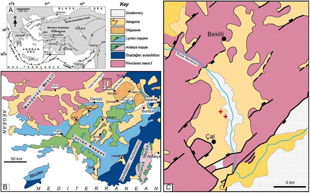
(A) Tectonic map of the eastern Mediterranean showing major fault zones (after Alçiçek et al., 2006). (B) Simplified geological map of the SW Anatolia (based on Şenel, 1997), showing the main tectonic and sedimentary units; the study area is indicated by the rectangle. (C) Geological map of the Çal Basin (revised compilation from Konak, 2002; Konak et al., 1986); the red asterisks indicate fossil-bearing sites.
(A) Carte tectonique de la Méditerranée orientale montrant les zones de failles majeures (d’après Alçiçek et al., 2006). (B) Carte géologique simplifiée du Sud-Ouest de l’Anatolie (basé sur Şenel, 1997) montrant les principales unités tectoniques et sédimentaires ; la zone étudiée est indiquée par le rectangle. (C) Carte géologique du bassin du Çal (compilation révisée à partir de Konak, 2002 ; Konak et al., 1986). Les astérisques rouges indiquent les sites fossilifères.
The Menderes Massif is a dome-shaped core complex of an Africa-derived microcontinent accreted to the Cimmerian margin of Eurasia during the earlier Pontide phase of the Alpine orogeny. The massif consists of a crystalline core and metamorphic cover rocks. At least some of the Lycian nappes are thought to have been tectonically transported to the southeast across the Menderes Massif when the Beydağları crustal block was accreted to the massif during the Tauride orogenic phase. The basement of the Beydağları block is unknown, deeply buried under a thick autochthonous platform of Mesozoic carbonates. The Lycian nappes consist mainly of Mesozoic carbonate rocks and late Mesozoic–Palaeogene ultramafic rocks, whereas the Antalya nappe is virtually dominated by Mesozoic ophiolites. The Antalya nappe was emplaced westwards when the Africa-derived Beydağları block collided with a sister block to the east (Collins and Robertson, 2003; Okay et al., 2001; Şengör and Yılmaz, 1981; Ten Veen et al., 2009; van Hinsbergen, 2010).
Near the end of Palaeogene, the western Tauride orogen became subject to tectonic collapse as a result of the post-orogenic uplift of thickened lithosphere combined with the strongly extensional regime of the adjoining Aegean region to the west (Fig. 1A; Candan et al., 1997; Ring et al., 1999; Thomson and Ring, 2006). The extensional collapse resulted in a broad array of orogen-top Neogene terrestrial basins, trending mainly SW−NE and SE−NW (Fig. 1B). Their tectonic development, palaeogeographical evolution and stratigraphy have been extensively studied in the last decade (Alçiçek, 2001, 2007; Alçiçek and Ten Veen, 2008; Alçiçek et al., 2005, 2006; Seyitoğlu et al., 2009; Ten Veen et al., 2009). One of these fault-bounded Neogene depressions is the Çal Basin (Fig. 1 C), which has earlier been mapped (Konak et al., 1986) but little studied in detail and whose deposits and the stratigraphical position of some new fossil fauna are described here for the first time.
3 The basin-fill succession
The basin-fill succession of the Çal Basin was referred to by Konak et al. (1986) as the Asartepe Formation and was assigned a Quaternary age on the basis of a superficial comparison with some of the neighbouring basins. In the ensuing section, the sedimentary facies of the basin-fill succession are described and its stratigraphic age is revised on the basis of terrestrial mammal remains, including more recent findings (Kaya et al., 2008) and a newly discovered site.
The basin-fill succession overlies unconformably the metamorphic bedrock of the Menderes Massif and consists of two depositional sequences, which are separated by an angular unconformity and referred to here informally as the Lower Unit and Upper Unit (Figs. 2 and 3A). The thickness of each unit varies laterally according to the palaeotopographic relief, reaching 60 and 25 m, respectively. The principal sedimentary characteristics of the succession are summarized in Fig. 2, with a distinction of three main facies associations−interpreted as the deposits of alluvial-fan, fluvial and palustrine environments.
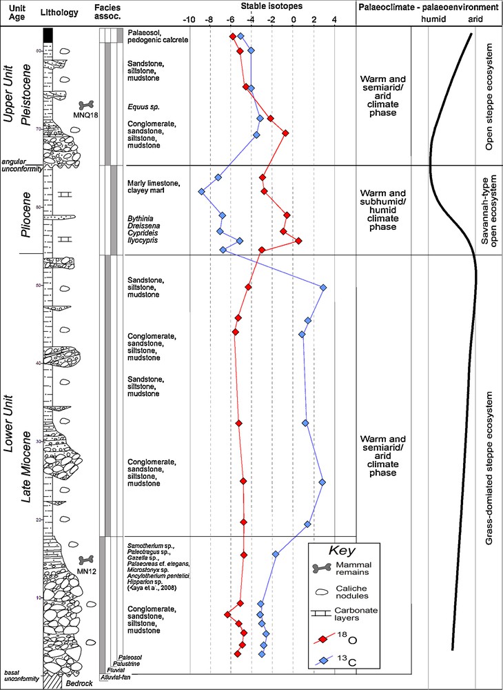
Composite stratigraphy and review of main characteristics of the Neogene-Quaternary depositional history of the Çal Basin, including sedimentological, palaeontological, mineralogical and geochemical data and their palaeoenvironmental interpretation. Facies associations: AF: alluvial-fan deposits, Fl: fluvial deposits, Pl: palustrine deposits.
Stratigraphie composite et revue des principales caractéristiques de l’histoire des dépôts néogènes et quaternaires du bassin du Çal, comportant les données sédimentologiques, paléontologiques, minérales et géochimiques et leur interprétation paléoenvironnementale. Associations de faciès : AF : dépôts d’éventails alluviaux, F1 : dépôts fluviatiles, Pl : dépôts palustres.
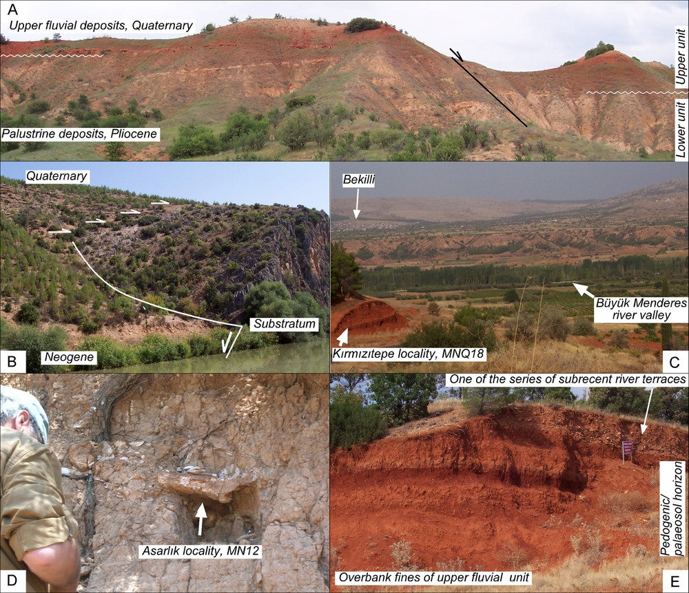
Outcrop photographs of the key localities in the basin. (A) Panoramic view of the angular unconformity separating the Lower Unit and Upper Unit of the Çal basin-fill succession. (B) Tectonic boundary and depositional onlap at the eastern basin margin along the Büyük Menderes river gorge, involving alluvial-fan deposits and bedrock. The onlapping alluvial deposits pass laterally into palustrine deposits, which is attributed to a decreased denudation rate in the basin in early Pliocene. (C) Panoramic view of the Çal Basin. Note the palaeosol layer at the top of the basin-fill succession at the road-cut, forming a broad plateau on which the towns of Çal and Bekili are located (upper left). (D) The late Miocene (biozone MN12, Turolian) fossil site in the flood plain deposits near Asarlık. (E) The distinctive palaeosol horizon at the top of the basin-fill succession exposed in a river terrace.
Photographies d’affleurements dans les localités clé du bassin. (A) Vue panoramique de la discordance angulaire séparant l’Unité inférieure de l’Unité supérieure de remplissage du bassin. (B) Limite tectonique et recouvrement sédimentaire sur la marge orientale du bassin, le long de la gorge de la rivière Büyük Menderes, comportant des dépôts d’éventails alluviaux et la roche-mère. Les dépôts alluviaux de recouvrement passent latéralement à des dépôts palustres, ce qui est attribué à un taux de dénudation décroissant dans le bassin, au Pliocène inférieur. (C) Vue panoramique du bassin de Çal. À noter que l’horizon de paléosol au sommet des dépôts de remplissage du bassin sur la tranchée de la route forme un large plateau sur lequel est installée la ville de Çal (en haut ; à gauche). Site fossilifère fini-Miocène (biozone MN12, Turolien) dans les dépôts de la plaine d’inondation, près d’Asarlik. (E). Horizon de paléosol distinct, au sommet du remplissage du bassin, exposé sur une terrasse de la rivière.
3.1 Alluvial-fan deposits
This facies association constitutes the lowermost part of the basin-fill succession (Fig. 2), thickening towards the basin boundary faults and both thinning out and fining basinwards (Fig. 3B). The deposits are reddened, comprising conglomerates intercalated with stratified pebbly sandstone beds and minor mudstone layers. Conglomerates are matrix-supported and non-stratified, composed of angular to sub-angular clasts and a mud-bearing sandy matrix. Their beds have sharp or recognizably erosional bases and are most commonly non-graded, but occasionally show normal grading or coarse-tail inverse grading. Sandstones are medium- to fine-grained and moderately sorted, forming sheets with planar parallel stratification, often gently inclined. Mudstones are greyish-brown in colour, massive to faintly laminated, forming broad sheets with pedogenic carbonate nodules, plant detritus and plant-root traces. XRD analyses of the calcrete nodules indicate calcite (75.7%), dolomite (15.3%), quartz and feldspar (4.9%) and clay minerals (4.1%). The δ18O isotopic ratio of the nodules varies and is relatively low (from −6.20 to −4.85 ‰), whereas the δ13C ratio ranges between −3.32 and −1.95 ‰.
The occurrence of plant-root casts and calcrete indicates a terrestrial environment. The conglomerate facies is interpreted to be deposits of subaerial debris flows, sporadically turbulent enough to develop normal grading (hyperconcentrated sheetfloods sensu Nemec and Muszyński, 1982). The sandstone facies represents episodic turbulent sheetfloods transporting sediment in upper stage plane-bed traction and generally reaching farthest into the basin. The mudstone facies is interpreted to be a result of floodwater ponding in subtle topographic depressions, combined with periods of low sediment supply (Abdul Aziz et al., 2003; Melchor, 2007; Pimentel, 2002; Sanz et al., 1995). This facies association indicates an alluvial-fan environment. Near Asarlık (locality UTM 4221175-0712230, 705 m a.s.l.), ∼3 km northeast of the city of Çal, MCA has found and Kaya et al. (2008) reported a fossil mammal site (Fig. 3D) with abundant Artiodactyla Giraffidae (Samotherium sp., Palaeotragus sp.), Bovidae (Gazella sp., Palaeoreas cf. elegans), Suidae (Microstonyx sp.), Perissodactyla Chalicotheriidae (Ancylotherium pentelici) and Equidae (Hipparion sp.), as indicative of a middle Turolian age (biozone MN12, late Tortonian).
3.2 Fluvial deposits
This facies association constitutes the thick middle part of the Lower Unit and the entire Upper Unit of the basin-fill succession (Fig. 2). The deposits include poorly stratified conglomerates, sandstones with planar parallel stratification, planar cross-stratification and ripple cross-lamination, and associated mudstones that commonly dominate volumetrically. Sandstones occur as isolated sheet-like beds, whereas the conglomerates in association with sandstones form fining-upwards bodies with high-relief erosional bases and transversely inclined bedding. Conglomerate beds consist of subangular to subrounded, moderately sorted clasts and are characterized by a clast-supported, sand-filled texture. Sandstone beds are coarse- to fine-grained, contain plant detritus and are generally well stratified, only occasionally massive. Mudstones are dark reddish-brown in colour and massive, contain calcrete horizons and are intercalated with the layers of silt and poorly to moderately sorted sand, commonly bearing pebbles and sporadic cobbles. XRD analyses of calcrete nodules in the Lower Unit indicate calcite (85%) with a minor admixture of dolomite (9.4%), quartz and feldspar (3.3%) and clay minerals (2.3%). The δ18O isotopic ratio of the calcrete is between −5.85 and −2.94‰, whereas the δ13C ratio ranges from +1.65 to +3.92‰.
The conglomerate-sandstone packages are interpreted to be palaeochannels of meandering rivers, with the lateral accretion of sediment as point bars. The isolated sandstone sheets are thought to be crevasse-splay deposits embedded in overbank floodplain mudstones (e.g. Anadón et al., 1998; Capuzzo and Wetzel, 2004; Miall, 1996). The relatively thick mudstone deposits are consistent with a meandering character of the fluvial system.
A distinct palaeosol horizon, 40−60 cm thick (Fig. 3 C), occurs at the top of fluvial deposits in the Upper Unit (Fig. 2) in the central part of the basin, forming an extensive plateau preserved as hanging terraces on both sides of the Büyük Menderes river valley (Fig. 3E). The sediment has been intensely reddened (10R4/4 to 5YR4/6), which indicates strong intrastratal oxidation leading to the formation of haematitic pigment. Pedogenic features include calcrete nodules, plant-root traces, blocky soil-like texture, desiccation cracks and obliterated primary lamination. XRD analyses of calcrete nodules indicate calcite (73.6%) with minor amounts of dolomite (12%), quartz and feldspar (8%) and clay minerals (6.4%). The δ18O isotopic ratio is between −5.82 and −1.23 ‰ and the δ13C ratio is between -4.14 and −3.45 ‰.
In the fluvial facies assemblage of the Upper Unit near Kırmızıtepe (locality UTM 4220910-0712305, 753 m a.s.l.), ∼3 km northeast of the city of Çal, a new fossil mammal site has been found by MCA that abounds in Equidae (Equus sp.). The fossil is single metapodial belonged to a small equid, and base on size and morphology, it is very close to the common fossil equid, E. hydruntinus which indicates a late Pleistocene age of the deposits (Biharian, biozone MNQ18).
3.3 Palustrine deposits
This facies association forms the uppermost part of the Lower Unit, overlying conformably its fluvial deposits and covered disconformably by the fluvial deposits of the Upper Unit. It is up to 4−5 m thick and a few hundred metres in lateral extent, but its extensively erosional and angularly unconformable upper boundary suggests a considerable reduction of primary thickness. The deposits are thinly bedded, alternating massive to laminated marly limestones and clayey marls. The clayey marls are greenish-grey to grey and massive, only locally parallel-laminated. Their beds are 5−40 cm thick, tabular or lenticular and up to several tens of metres in lateral extent. XRD analyses of limestones indicate calcite (68.5%), dolomite (21.7%), quartz and feldspar (5.8%) and clay minerals (4%). The δ18O isotopic ratio is between −8.47 to −5.61 ‰, whereas the δ13C ratio ranges from −3.47 to −1.13 ‰.
The deposits abound in freshwater ostracods Bythinia, Dreissena, Cyprideis and Ilyocypris, indicating a standing water body. Large pipe-like pores indicate subaqueous decay of plant rootlets. The predominance of carbonates with mudstone to wackestone textures supports the notion of palustrine sedimentation in shallow lakes with fluctuating water level (Platt and Wright, 1992; Ramos et al., 2001). The scarcity of terrigenous sediment indicates low wave fetch (small lake size) and suggests that the lakes might have been surrounded by wide flats acting as filters for clastic sediment supply and/or that there was relatively little sediment yield from the surrounding hinterlands during this period (Armenteros and Daley, 1997; Freytet and Plaziat, 1982).
4 Palaeogeographical reconstruction
The terrestrial sedimentation in the study area commenced in the Late Tortonian, when a half-graben basin formed with alluvial fans extending away from its boundary fault escarpment (Fig. 4A). This original basin initially comprised the area of the Baklan and Çal basins, and its formation is attributed to a rifting pulse recognizable throughout the western Taurides (Alçiçek, 2007; Alçiçek et al., 2005). The alluvial redbeds and abundance of debris-flow deposits reflect climatic aridity. A semiarid to arid, oxidizing environment is also indicated by pedogenic carbonates, with their negative δ18O isotope ratios and strongly negative δ18O/δ13C covarience (correlation coefficient r ≈−0.70). The overlying meandering-river alluvium with floodplain deposits indicates an increase in climate humidity towards the end of Miocene, which correlates with a regional climatic change (Alçiçek, 2007; Alçiçek et al., 2005).
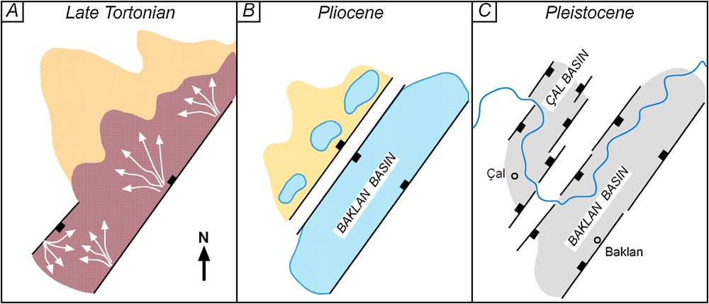
Interpreted development and palaeogeographical evolution of the Çal Basin. (A) A broad half-graben forms in the late Tortonian, comprising the area of the future Çal and Baklan basins. Alluvial-fans are gradually replaced by axial fluvial system. (B) New rifting pulse splits the basin into the Çal half-graben and Baklan graben, both dominated by palustrine environments. (C) Late Pliocene rifting pulse turns the Çal Basin into a graben with axial fluvial system.
Interprétation du développement et de l’évolution paléogéographique du bassin de Çal. (A). Un large demi-graben s’est formé au Tortonien supérieur, comportant la zone des futurs bassins du Çal et de Baklan. Les éventails alluviaux sont graduellement remplacés par un système fluviatile axial. (B). Une nouvelle phase de rifting divise le bassin en semi-graben de Çal et graben de Baklan, où les environnements palustres dominent dans les deux cas. (C). La phase de rifting du Pliocène supérieur transforme le bassin de Çal en un graben à système axial fluviatile.
Another pulse of rifting occurred in the Early Pliocene, splitting the original basin into a narrower half-graben (Çal Basin) and a graben (Baklan Basin). The associated palaeogeographical change (Fig. 4B) coincided with greater climatic humidity, whereas the tectonic re-structuring of the basin constricted water drainage and provided accommodation space for lakes. A palustrine environment with coastal mires formed in the basins. The δ18O ratios of palustrine carbonates are lower than those of the underlying pedogenic carbonates associated with fluvial floodplains and also their δ18O/δ13C covariance is weak (correlation coefficient r ≈−0.32). Freshwater ostracod fauna in the palustrine deposits (Fig. 2) supports the notion of warm, subhumid to humid climatic conditions. Lakes formed concurrently in several other basins of in the region, with cyprinod fish remains reported from the Baklan Basin (Rutte and Becker-Platen, 1980), micromammal fossils found in the Çameli Basin (Alçiçek, 2001; Alçiçek et al., 2005), Eşen Basin (Alçiçek, 2007) and Denizli Basin (Alçiçek et al., 2007).
The post-Miocene increase in climate humidity is widely recognized in the eastern Mediterranean (e.g., Krijgsman et al., 1999) and attributed to the marine flooding that marked the end of the Messinian drought event known as ‘salinity crisis’ (Hsü et al., 1973). The dramatic rise in sea level raised the base level of fluvial systems, reducing sediment yield and promoting widespread palustrine conditions. A similar rapid change at the Miocene/Pliocene transition has been documented by isotopic studies and mollusc remains in the Denizli Basin to the south (Alçiçek, 2010; Alçiçek et al., 2007; Wesselingh et al., 2008) and recognized in the adjacent Çameli and Eşen basins (Alçiçek, 2007; Alçiçek et al., 2005). The Late Pliocene lake-margin deposits in the Baklan Basin contain cardiid bivalves Monodacna imrei, which indicate humid climatic conditions throughout the Pliocene (Wesselingh and Alçiçek, 2010).
Another pulse of rifting occurred in the early Pleistocene, marking also a change in the direction of regional tectonic extension (Alçiçek, 2007; Alçiçek et al., 2005; Ten Veen et al., 2009). As a result, several new faults formed and the Çal Basin became a graben (Fig. 4 C), with its floor significantly tilted to the southeast. The event was recorded by the angular unconformity and renewed supply of coarse-clastic fluvial sediment to the basin (Fig. 2). The fossil content of overbank floodplain deposits indicates an open-steppe habitat and warm, semiarid to arid climatic conditions. The increasingly negative δ18O isotopic ratios (Fig. 2) and strong positive δ18O/δ13C covariance (correlation coefficient r ≈ 0.76) of pedogenic carbonates indicate semiarid/arid conditions with a diagenetic overprint of meteoric water (Alonso-Zarza and Arenas, 2004; Wright, 1997).
5 Regional correlation
Inter-basinal correlations of terrestrial sedimentary successions are generally hindered by the scarcity of fossil fauna remains. Therefore, every new site of fauna occurrence is crucial to the basin stratigraphy and its regional correlation, which helps to improve our understanding of the crustal and palaeogeographical development in western Anatolia after the local tectonism corresponding to the Alpine orogeny. The fauna findings in the Çal Basin allow its palaeogeographical evolution to be correlated and compared with that of the adjacent basins; for example, the Uşak-Güre Basin to the north (Seyitoğlu et al., 2009), where the Kemiklitepe site yielded important palaeontological evidence (Şen et al., 1994), or the Baklan Basin to the east, where crucial evidence of mammal fossils was derived from the Mahmutgazi site (Sickenberg and Tobien, 1971). The fossil mammal remains in the Çal Basin correlate well with the sites in the neighbouring basins (Fig. 5), which indicates palaeobiogeographical connections and unhindered migration of mammal fauna. Preliminary biostratigraphic framework for the well-known Mahmutgazi and Kemiklitepe A/B localities in the addition of the new fauna of Karabelyi in the Uşak-Güre Basin closely follow those of late Miocene (middle Turolian) localities from SE Mediterranean (Kaya et al., 2008, 2011; Kostopoulos, 2009) and the similarity of the faunal lists shows that the Asarlık fauna must also be assigned to this age (Fig. 6). However, despite the similarities between Asarlik and the other faunas, a general distinction is also apparent. Specifically, the carnivores from Mahmutgazi are indicative of a slightly older age since the same carnivores were already found and well-studied in Kemiklitepe A/B (Table 1). Consequently, both sites seem to have been more similar to forest/woodland environments which are consistent with the existence of amphibious type adapted giant hyrax in Kemiklitepe A/B and the dominant occurrence of felids and ursids in both faunas. Contrary to former localities, Hipparion is the most common element of Asarlik and Karabeyli faunas which marks a more open environment than the former sites.
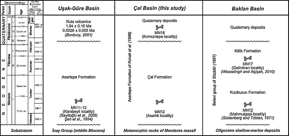
Correlative stratigraphy of the Uşak-Güre, Çal and Baklan basins. For the basin locations, see Fig. 1B. The chronostratigraphic units are based on International Commission on Stratigraphy–2010 and the central European land mammal biozones compiled by Harzhauser and Mandic (2008). (Figure makes reference to Bunbury et al., (2001), Konak et al. (1986), Şen et al. (1994), Seyitoğlu et al. (2009), Sickenberg and Tobien (1971), Sözbilir (1997), Wesselingh and Alçiçek (2010))
Corrélation stratigraphique entre bassins de Uçak-Güre, Çal et Baklan. Pour la localisation des bassins, voir Fig. 1B. Les unités chronostratigraphiques sont basées sur les recommandations de la Commission internationale de Stratigraphie (2010) et les biozones de mammifères terrestres de l’Europe centrale compilées par Harzhauser et Mandic (2008).
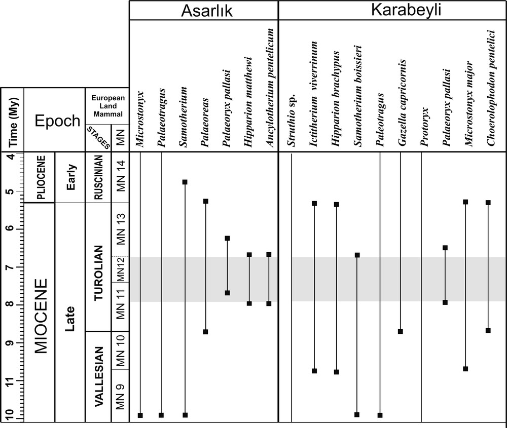
Biostratigraphic range, correlation and biochronologic interpretation of the Asarlık in the Çal basin and closest site of Karabeyli in the neighbourhood Uşak-Güre Basin to the west. The chronostratigraphic units are based on International Commission on Stratigraphy–2010 and the central European land mammal biozones compiled by Harzhauser and Mandic (2008).
Rang biostratigraphique, corrélation et interprétation biochronologique de l’Asarlik dans le bassin de Çal et du plus proche site de Karabeyli, dans le voisinage, à l’ouest. Les unités chronostratigraphiques sont basées sur les recommandations de la Commission internationale de Stratigraphie (2010) et sur les biozones de mammifères terrestres de l’Europe centrale, compilées par Harzhauser and Mandic (2008).
Les listes fauniques des localités à mammifères fossiles considérées dans cette étude (Kaya et al., 2008, 2011 ; Köhler, 1987 ; Pickford et Ertürk, 1979 ; Schmidt-Kittler, 1976 ; Şen et al., 1994 ; Seyitoğlu et al., 2009).
| Karabeyli | Kemiklitepe A/B | Asarlık | Mahmutgazi |
| Struthio sp. Ictitherium viverrinum Hipparion brachypus Hipparion sp. (II) (small) Paleotragus sp. Gazella cf. capricornis. Protoryx sp. Palaeoryx pallasi Microstonyx major Samotherium boissieri Choerolophodon pentelici |
Pseudomeriones sp. Hystrix primigenia Hyaenotherium wongii Adcrocuta eximia Lycyaena sp. Machairodus giganteus Indarctos sp. Choerolophodon pentelici Ancylotherium pentelicum Diceros neumayri Hipparion matthewi Hipparion mediterraneum Pliohyrax graecus Orycteropus gaudryi Palaeotragus rouenii Samotherium major Gazella sp. Skoufotragus laticeps |
Ancylotherium pentelicum Hipparion matthewi Hipparion sp. II (large) Microstonyx sp. Palaeotragus sp. Samotherium sp. Gazella sp. Palaeoreas sp. Palaeoryx pallasi |
Parapodemus sp. Protictitherium crassum Adcrocuta eximia Machairodus aphanistus Indarctos atticus Choerolophodon pentelici Chilotherium schlosseri Diceros neumayri Hipparion cf. macedonicum Orycteropus sp. Microstonyx major Palaeotragus coelophrys Samotherium boissieri Gazella sp. Miotragocerus valencienesi Palaeoryx pallasi Sporadotragus parvidens Tragoportax amalthea Plesiaddax cf. inundatus Palaeoreas lindermayeri Oioceros wegneri |
As pointed out by Alçiçek (2010), the climate in south-western Anatolia during the late Miocene was semiarid to arid, with a grass-dominated steppe ecosystem, but changed dramatically into humid in the early Pliocene, with widespread lakes and palustrine conditions. The climate in the latest Pliocene was warm and humid, with extensive lakes and savannah-type open habitats evidenced by the mammal record. By the Late Villanyian, a regional climatic deterioration brought about a spell of aridity that persisted until Biharian. During the Holocene, the climate became more arid and mammal associations had adapted to this change, increasingly resembling present-day fauna. The faunal and palaeoenvironmental evidence from the Çal Basin is consistent with this regional trend.
6 Conclusions
The sedimentary basin-fill succession of the Çal Basin recorded a late Miocene sedimentation involving alluvial fans and meandering river environment, followed by a predominance of widespread palustrine environments in the Pliocene. Fossil fauna indicates a warm and arid to semiarid late Miocene climate and a warm subhumid to humid Pliocene climate. Pleistocene deposits indicate a marked increase in clastic sediment supply and return of fluvial environment in semiarid to arid climatic conditions. The climate could be seasonal and involve water yield from the melting of winter snow-pack on adjacent high mountains ridges (Nemec and Kazancı, 1999), which might explain the intra-basinal fluvial activity in generally arid/semiarid regional conditions.
The structural development of the Çal Basin, its internal sedimentation pattern and palaeoenvironmental changes correlate well with those in the neighbouring Neogene basins, recording regional pulses of tectonic extension and major climatic changes. The inter-basinal correlation was made possible by the findings of fossil fauna, particularly mammalian taxa, which also render the Çal Basin an important stratigraphic reference for the region's Miocene−Pleistocene geological history.
Acknowledgements
The study was sponsored by TUBITAK (research grant 105Y280) and Turkish Academy of Sciences. Constructive reviews from W. Nemec (Bergen Univ.) and L. van den Hoek Ostende (NCB Naturalis) have improved the original manuscript.