

1 Introduction
Many estuaries have been subjected to strong human impacts (Blott et al., 2006; Hossain et al., 2004; Lesourd et al., 2003; Morris and Mitchell, 2013; Pye and Blott, 2014; Thomas et al., 2002; Tonis et al., 2002; Van der Wal et al., 2002; Wolanski, 2006; Wolanski et al., 2001). Among them the macrotidal Seine estuary is a good example. During the last decades, a strong artificial reduction in the accommodation space, superimposed on natural variations, has led to a downstream shift of the sedimentation area. The comparison of old nautical charts and sedimentological data from the 19th century shows an increase in fine-grained sedimentation (i.e. mud, grain size < 63 μm) in the outlet of the Seine River, as well as in the shallow waters of the Bay of the Seine. The modern fine-grained deposition extends to the open subtidal shallow area (Lesourd et al., 2001; Lesueur et al., 2003). As a result in the mouth of the Seine estuary, cores show a fining up regressive sequence that corresponds to a shift from an inner shelf term with pebbles and coarse sands, to an estuarine term with mud and fine sand (Lesourd et al., 2001). Moreover, the distribution of superficial sediment is governed by seasonal variations, depending on both the river discharge intensity and the wave activity (Lesourd et al., 2003): when 55% of the total mouth area is covered by mud at the end of the winter, this amount is approximately of 24% at the end of the summer.
The aim of this study is to understand the evolution of the superficial sedimentation, over the last 150 years. The main question is to estimate the impact of engineering works on the sedimentation of an estuary. The set of data on superficial sediment is extensive enough and coherent to permit a correlation with the hydrodynamic context, such as the river flow rate on the sedimentation. Beyond this question, this study involves a larger work of monitoring of an estuary submitted to strong human impact since the middle of the 19th century, using an original set of data, useful for monitoring the evolution of the estuary.
2 Background
The Seine is the largest river that flows into the English Channel (La Manche). It has a length of 780 km and a catchment area of 78,000 km2 in which 40% of the French population and economic activity is concentrated (Paris Basin). The Seine estuary is the result of the drowning of the Weichselian incised valley during the Holocene transgression (Lefebvre et al., 1974), as is the case of many modern estuaries (Dalrymple et al., 1992; Fairbridge, 1980; Perillo, 1996). The present-day morphology of the downstream part of the Seine is the result of its filling during the Holocene (Lesueur et al., 2003; Tessier, 2012; Tessier et al., 2010). The downstream part of the Seine estuary is funnel-shaped with a mouth that opens towards the west with elongated sand bars that are typical of tide-dominated estuaries (Dalrymple et al., 1992). The mean river discharge is 400 m3/s (1940–2014 average, measurement at Poses Lock, see Fig. 1), with mean extreme values of 200–2000 m3/s1. The mean annual mass of suspended particulate matter (SPM) in the river discharge is estimated to be about 6 × 10⁵ T/year (GIP Seine-Aval), with marked variations over years, extreme values being 1.3 × 10⁵–1.7 × 10⁶ T/year (“Service de navigation de la Seine”, unpublished data). The modalities of sediment supply according to fresh water flow have been documented in Avoine (1987), Guézennec et al. (1999), and Lesourd et al. (2003). A great part of SPM and mud of the study area originates from the catchment area of the Seine River (Dubrulle et al., 2007). The sediment cover is mostly composed of fine-grained material (silt and clay). The tidal amplitude at Le Havre is 3 m during neap tides and 7.5 m during spring tides. A flow velocity up to 2.5 m/s at the surface (1.60 m/s on the bottom) can occur during the rising tide. The tidal cycle is semi-diurnal with a high water slack close to 3 h. In the Seine estuary, as in other macrotidal estuaries, the suspended sediment concentration in the turbidity maximum (TM) is mainly governed by tidal currents (Allen et al., 1980; Avoine, 1987; Brenon and Le Hir, 1999; Le Hir et al., 2001; Li et al., 1995; Mitchell et al., 2003, 2012; Salomon and Allen, 1983; Wells, 1995). The suspended sediment concentration varies from 0.1 to 1 g/L, associated with fluid mud (100–300 g/L), during a semi-lunar tidal cycle. The total mass of the TM varies from 2 × 10⁵ T during neap tide to 4 × 10⁶ T during spring tide (Avoine et al., 1981), with a longitudinal oscillation of the mass gravity centre of the TM of about 20 km. During high river output, a varying but large proportion of the SPM contained in the TM is expelled out to the Bay of the Seine (Avoine, 1987). Propagation of swells within the Seine estuary is highly complex and poorly documented. Complexity is due to the uneven morphology (sand bars, embankments) and water depths that vary rapidly with the tide conditions. Nevertheless, the Seine estuary is mainly subjected to westerly to north-westerly swells and to waves generated by local winds in the Bay of the Seine, with a westerly dominance.
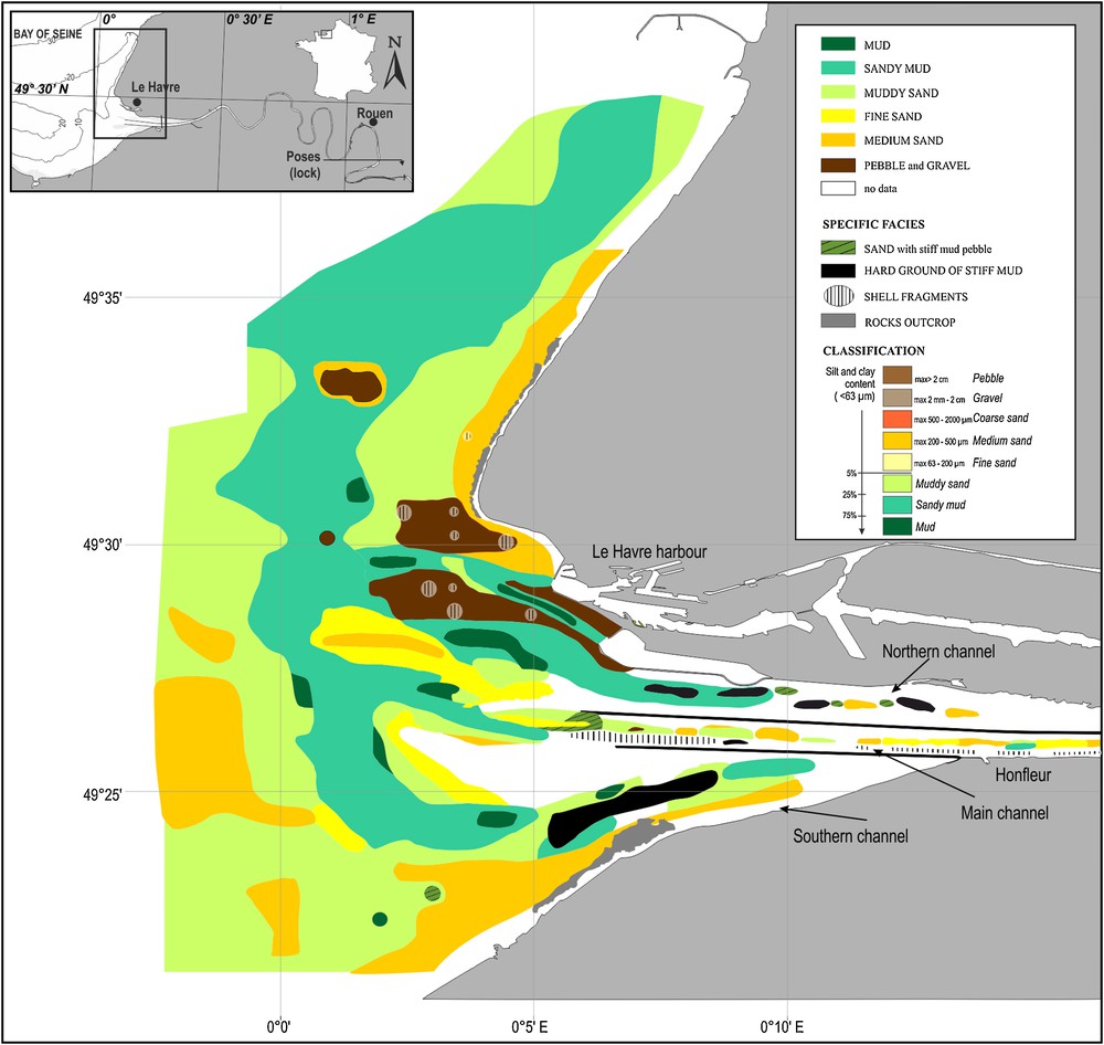
Map of superficial sediment in the mouth (08°E to 0°; 49°23 to 49°32 N) of the Seine estuary, including part of the main navigation channel and the northern and southern channels, based on the 2009–2010 sampling campaign data. According to silt and clay contents: sand (< 5%), muddy sand (5–25%), sandy mud (25–75%), mud (> 75%). Pebble facies are interpreted as in a previous study (Lesourd et al., 2001; Lesueur et al., 2003) using drilling, for the same area (see Fig. 2).
3 Material and methods
A new set of superficial sediments samples (Table 1) has been collected in the mouth of the Seine estuary during the years 2009–2010 (COLMATAGE project, in the framework of Seine-Aval program). Sample stations were chosen according to a regular grid (1 nautical mile spaced out). The set of data consists of a main sampling made during May 2009 (300 samples). Some additional samples were realized during years 2009–2010. Some of them (27) were reacquiring sample stations to study seasonal variations of the sedimentation. A total of 561 samples were analysed. It must be noticed that mapping by marine geophysics, such as side-scan sonar, is not relevant in the study area because the pictures show generally monotonous acoustics facies (Lesourd, unpublished data). Samples were taken with a Shipek grab and a Reineck box-corer; several samples were realized on each point to account for local facies variations and/or when the samples were not relevant (reworking of sedimentary layers during sampling, or empty grab).
Set of superficial sediments samples collected in the mouth of the Seine estuary during the years 2009–2010 (COLMATAGE project, in the framework of Seine-Aval program).
| Date | Number and method of sampling | Source | Construction work background for the study area (see Lesourd et al., 2001) | Flow rate background (see Fig. 3) |
| 19th century | Northern part, 1834, 364 sounding, southern part, 1883, 9310 soundings | SHOM, 1834–1883 | Savage estuary | Unknown |
| 1913 | 30,000 soundings | SHOM, 1913 | Construction works but upstream | Unknown |
| 1977 | 655 Shipeck grabs and 40 short cores | Avoine et al., 1981 | Just before the construction of major dikes | Normal flow rate dynamic |
| 1993–1996 | 1100 Shipeck grabs and 125 short cores, (12 sampling campaign) | Lesourd et al., 2001 | Continuous construction works | Normal flow rate dynamic |
| 2009 | 561 Shipeck grabs and 10 short cores (4 sampling campaigns in 2009–2010) | This study | Continuous construction works | After a long period of low flow rate |
Each sample was described and photographed. Sub-samplings were realized according to the sediment structuration. In the case of coarse sediments (gravel), the sediment was sieved in a dry environment using 15 sieves with French standard mesh sizes (i.e. AFNOR definition); the particle size distribution of the other samples was obtained with a Laser Coulter LS 230. The sedimentological classification of samples was established using both structural (as described in the grab after the sampling) and textural (grain size used to reinforce structural description) characteristics. The classification is displayed in Fig. 1.
The 2009 map (Fig. 1) has been obtained with manual correlation (Diesing et al., 2014), using bathymetric data associated with a knowledge based on more than 1500 samples realized in the Seine estuary since the 1990s. Areas were drawn using density of points, morphology (limit of bank, trough) and seasonal variations when a station was sampled during to several seasons. The high number of samples permits to draw a relevant map, but neither the density of samples (too few) nor variations of sedimentary facies (scattered geographical distribution) allow us to use statistical analyses to create the map. GIS software was used to calculate the area corresponding to the various facies.
The 2009 data, associated with four other maps (Fig. 2), form a very complete and original set allowing a better understanding of the story of the Seine estuary sediments.
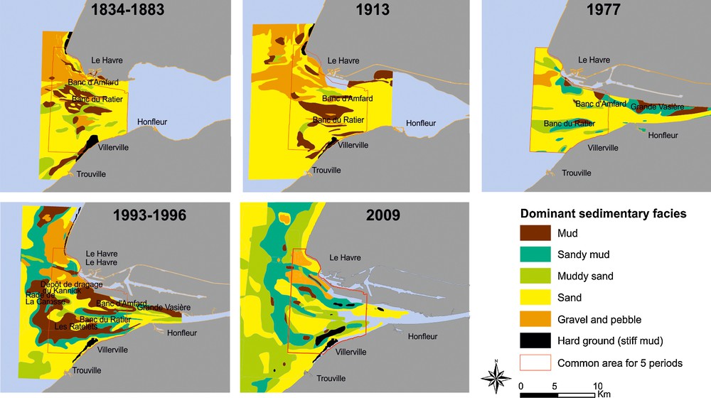
Sedimentary facies evolution of the Seine estuary over five periods of time (see Fig. 1 for grain size classification) Red line: delimitation of common area on which are calculated percentage areas corresponding to the different facies (mud, sandy mud, muddy sand and sand). See Table 1 for the source of data. According to silt and clay contents: sand (< 5%), muddy sand (5–25%), sandy mud (25–75%), mud (> 75%). Data: SHOM (1834–1883); SHOM (1913); Avoine et al. (1981); Lesourd et al. (2001).
4 Results and interpretation
The distribution of superficial sediments in the mouth of the Seine estuary (Fig. 1) shows in 2009–2010 a high diversity of facies. Most of the samples correspond to sandy mud or muddy sand, whereas very few of them (7%) contain more than 75% of silt and clay. Considering grain size, most of samples are a mixture of three main classes (> 200 μm, [63–200 μm], < 63 μm), involving an unsorted stock of sedimentary material. Sediments < 63 μm are composed of a constant proportion of coarse silts ([63–20 μm], around 30%), fine silts ([20–4 μm], 50%) and clay (< 4 μm, 20%). Four modes are revealed by the grain size laser analysis (18, 38, 97 and 200 μm), systematically detected, with variable relative proportions.
This 2009 map (Fig. 1) reveals a representation of all facies, with a scattered geographical distribution. A general overview shows:
- • the wide sand bars on the two sides of the end of the navigation channel;
- • a large geographical representation of sandy mud facies (25 to 75% of silt and clay);
- • an area of muddy sand facies juxtaposing coarse sand in the shallower water of the Bay of the Seine.
The northern channel is characterized by high-scattered facies, featuring reworking of both seabed and mudflats (originated in the formation of a new channel). The seabed of the navigation channel is also under the influence of permanent engineering works (i.e. dredging) and shows an inconstant pattern of facies, essentially shell fragments and mud pebbles, as discussed later. A number of samples correspond to pebble and gravel, generally Flandrian and ante-Flandrian material, difficult to sample with grabs, and more locally they correspond to outcrops of Mesozoic rocks. A kind of specific sediment is composed of very stiff ancient black mud characterizing the seabed of former channels, in the northern and southern margins of the estuary. Considering only the grain size, this facies is fine-grained (more than 85% of silt and clay) but nevertheless must be considered as outcrops. Above most of this facies, variable and temporary sedimentation including fluid mud or sand ripples can be found.
The mud facies (silt and clay > 75%) is poorly exposed, comparatively to the former 1996 study (see the map in Lesourd et al., 2001). Mud can be found around the large sand banks and within troughs. However, considering the visual description and not only the grain size analysis, silt and clay can be sampled as little mud pebbles of very soft mud, layering on the seabed, whatever the facies. These soft mud pebbles were not included in the grain size measurements, and could be found all over the study area, as diffuse mud deposits. They probably correspond to a residue of fluid mud deposits as the result of the expelling and deposition of turbidity maximum during flood events.
The sandy mud facies (25 to 75% of silt and clay) was very well represented on the whole mouth of the Seine estuary in 2009–2010. This facies occupies the former place of the mud facies, especially in the North of the estuary, where it replaces mud and covers coarse sand and muddy sand areas.
The muddy sand facies (5–25% of silt and clay) is also largely represented on this map, contrasting with the situation in 1996, when very few samples corresponded to this facies. More than a recovering of the former facies, this appears as a silt and clay enrichment of the sand, mostly on the external part of the estuary. So, muddy sand facies appears:
- • in the western part of the estuary, widely over the former area of muddy sand;
- • on the northwestern part of the estuary where the corresponding surface areas increase;
- • along the northern coast.
The former study (Lesueur et al., 2003; Lesourd et al., 2003) showed that the muddy area (i.e. muddy sand and sandy mud) did not pass to the west over the Greenwich meridian; this limit is up to 2° W according to the new sampling.
The sand facies (less than 5% of silt and clay) is poorly represented in the mouth of the Seine estuary, mainly extending at shallow depths, on both sides of the end of the dikes. Sand forms the top of wide banks, the northern one being mainly composed of thixotropic sand and probably supplied by the Kannick deposit of sediment dredging.
Some of the 2009 facies are very specific and new, compared to the 1996 map (Fig. 2). It is the case of shells layers, with samples that may contain up to 99% in weight of shells, either as fragments or entire. Some of them are found at the seabed of the navigation channel and northern channel; others are overlapping locally a seabed of gravels and pebbles. These deposits, easily transported, originate in the erosion and sorting of sediment by tidal currents and swells, but also under the dredging works of the navigation channel and Port 2000 works. Another specific facies corresponds to mud pebbles. They were described in the former 1996 situation (Lesourd et al., 2003), but very locally and as lower frequencies, and layering above the surface of other sediments. They were found just after strong gales that had eroded stiff mud deposits. In the present study, they appear as an individual facies, due to their wide extension over the whole study area and their high amounts in the corresponding sediments: mud pebbles represent up to 30% in weight of the samples. They are pebbles of stiff mud, mixed with a muddy sand or sandy mud. These heterometric pebbles are found in the navigation channel and in the northern channel, and, depending on the location, are the result of:
- • dismantling of the seabed by dredging works (in the navigation channel);
- • erosion of deposits by swells;
- • erosion of stiff mud of the northern mudflat associated with the shifting of the northern channel (due to the embankments of Le Havre Port 2000 works).
The evolution of superficial sediments from 1834–1883 to 1993–1996 was described and discussed by Lesourd et al. (2001). The contribution of our new data highlights the more recent evolution and the relative impact of hydrodynamic parameters (essentially river flow rates) on the sedimentation (Fig. 2). In the middle of 19th century, the Seine estuary was still considered as a “savage” (i.e. pristine) estuary, because it was not yet affected by dredging or the effects of major port works. In 1913, construction works are still localised upstream. During year 1977 and after, constructions are important in the estuary (major dikes finished in 1980). 1993–1996 and 2009 situations are also characterized by strong human impact. In the middle of the 19th century, about 65% of the superficial sediments were sands, transiting over outcrops of gravel and pebble, especially in the northern area. Muddy facies, poorly represented, were associated with troughs. In 1913, sands occupied the most part of the study area; in the northern area, sand ridges covered former gravel and pebble outcrops. Mud was found only in troughs. According to the 1977 situation, gravel and pebble outcrops have been covered by sand and sandy mud; the most frequent facies were still sandy, but the total mud area had increased. In the 1993–1996 situation, sand formed wide sand banks. Muddy and sandy mud facies were prevailing, spreading over sand, around the banks and at the bottom of the channels. The increase in muddy facies was then explained by the modification of water circulation, according to the construction of new dikes (Lesourd et al., 2003). The 2009 situation corresponds to the removal of the fine-grained sediments, the decrease in mud being balanced by the increase in mixed material, sandy mud and muddy sand; there has been also a clear westward extension of muddy sand.
The Seine River flow rates have been measured from the 1940s. Fig. 3 shows the number of days with a flow rate exceeding 700 m3/s, which is a rough threshold estimate from which flow rate could be high enough to induce a significant sedimentation in the mouth (Guézennec et al., 1999). The flow rate must be strong, but also long enough to induce “estuarine floods” (Garnaud et al., 2002, 2003), expelling the TM and associated fluid mud over the area of the mouth. During the end of the 1970s, the hydrological context was a strong and prolonged low flow rate period (e.g., only a few days with flow rate > 700 m3/s in 1977). During the mid-1990s (1996 map, Fig. 2), the number of days with river floods was significant (until 140 in 1995), whereas before 2009, the number of days with high flow rate was moderate (max 77), so that no strong fine sedimentation occurred during a period of about nine years.
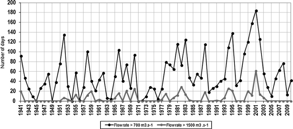
Annual occurrence of flood/high flow rate events over the 1941–2011 period. Black line: number of days when the flow rate exceeded 700 m3/s, rough estimate threshold from which the flow rate could be high enough to induce a significant sedimentation in the mouth. This number is an approach to measure the flow rate during a year. Grey line: number of days when the flow rate exceeded 1500 m3/s, which is a significantly strong flow rate for the Seine estuary.
For each set of available data, mid-19th century, 1913, 1977, 1993–1996 and 2009, the percentage of areas corresponding to the five main facies (mud, sandy mud, muddy sand, sand and gravel, and pebble) over the same total area of the mouth (Fig. 2) were calculated (Fig. 4). It first shows the very good consistency of this sedimentological indicator with the evolution described with maps, even with the oldest charts based on the tallow sounding method (19th century, 1913). The proportion of gravel and pebble, hard ground, and sand remained constant up to 1977. Nevertheless, from 1913 to 1977, a slight variation occurred between mud and sandy mud (due to the distinction between mud and sandy mud done since the 1997 study). The shift between the end of the 1970s (16% of surface area of mud and muddy sand) and the 1990s (about 50% in surface of mud and muddy sand) appears clearly. It must be noticed that the siltation of the Seine estuary is still nowadays important, but while the 1993–1996 muddy areas corresponded to thick layers (10 cm to locally up to 1 m) of mud covering a sandy and gravelly substratum, most samples in 2009 correspond to a mix of sand and mud without any internal structure. So, the decrease in the total muddy area was from about 40% in 1996 to 5% in 2009, balanced by an increase in sandy mud (from 14% to 24%) and muddy sand (from 6 to 22%) surfaces. During this time, the total area corresponding to sand has remained nearly the same. There is also a slight increase in hard ground surfaces, corresponding to outcropping stiff mud.
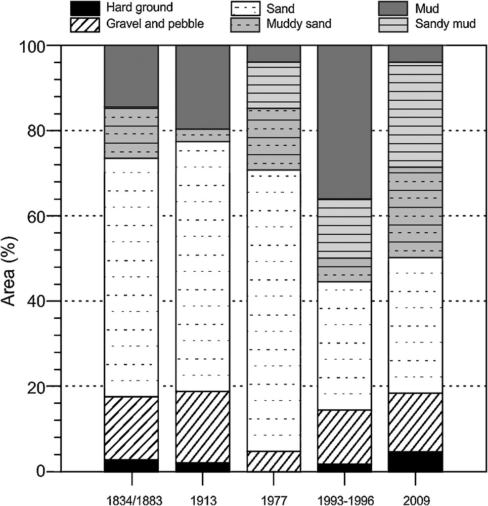
Percentages of areas corresponding to the different facies (mud, sandy mud, muddy sand and sand) in their proportion of the common estuary mouth area (red delimitation, Fig. 2), calculated for each set of available data (19th century/around 1850, 1913, 1977, 1993–1996 and 2009). According to silt and clay contents: sand (< 5%), muddy sand (5–25%), sandy mud (25–75%), mud (> 75%). Sandy mud facies is not discriminated for 1834/1883 and 1913, and merged with mud facies.
5 Discussion
Superficial sedimentation of estuaries evolves according to multi-decennial and seasonal time-scales, as described in the Hudson River (Woodruff et al., 2001) or in the Humber-Ouse (Uncles et al., 1998). In the lower Seine estuary (Lesourd et al., 2003), superficial sediments have been shown to be submitted to significant seasonal changes during the years 1993–1996: mud and sandy mud covered 55% of surface during winter, when the turbidity maximum commonly shifted toward the mouth during high river flows, inducing mud deposition, whereas 24% of the surface was characterized by mud and sandy mud during the summer period. At the end of the winter, fine-grained sediment can be reworked and scattered over the estuary, a part being transported upstream (channels and feeding the TM), another part being expelled to the Bay of the Seine.
The new set of samples collected in 2009–2010 includes a number of reacquiring sampling stations (RSS). Seasonal variations were very light for both grain size (% < 63 μm) and facies. This involves a weak impact of mud supplies by the river during few high flow rate periods. Areas with strong seasonal evolution are seabed composed of stiff mud, occasionally covered with sand or fluid mud. Areas with slight variations are essentially localized around sand banks, suggesting a moving boundary of these banks, with a variation of facies from sandy mud to muddy sand.
The evolution of superficial sediments is an indicator characterizing the morphological evolution of the Seine estuary. Maps have shown a clear evolution from sand-dominated seabed, as generally in estuaries (Dalrymple et al., 1992; Perillo, 1996) to seabed mainly composed of sandy mud, then mud. This evolution is correlated with the anthropogenic evolution of estuary (Lesourd et al., 2001; Morris and Mitchell, 2013; Thomas et al., 2002; Van der Wal et al., 2002; Wolanski, 2006). The evolution illustrated by the 2009 data is characterized by:
- • a strong decrease in the total mud facies area (facies with more than 75% of silt and clay);
- • a shift from mud and sandy mud to muddy sand;
- • a decrease in sandy area balanced by an increase in muddy sand area;
- • the extension of the muddy sand area by 4 km beyond the former known boundaries.
The fine-grained sediment did not disappear in the study area, but has spread over the estuary and has been incorporated in the sandy fraction. The silt and clay content of the Seine estuary is also still significant.
The ratio between the mud-dominated area (surface of mud and sandy mud) and the sand-dominated area (surface of sand and muddy sand) is a good indicator of the temporal changes of the superficial sediment (Fig. 5). It is calculated over a common area on the five maps, as shown in Fig. 2. Before 1977, this ratio was around 0.25. The change between 1977 and 1993–1996 appears very clearly, with a ratio increasing up to 1.5. The most recent data (2009) correspond to a ratio of 0.54, illustrating the persistence of the silt and clay content in the sediment and a spreading of mud over the area. Silt and clay content increase by settling on the seabed and mixing by current and swell. Stiff mud pebbles are specific sources of siltation when they rest on the top of the seabed and are transported by tidal currents and swells. Eroded by abrasion, they release a fine-grained material, mainly in the water but also inside the sediment. As observed in the most recent samples, they can be incorporated into sand or muddy sand. Trapped mud balls are also mixed within the sediment, leading to an internal mud supply. Observations of many grab contents show pebbles being eroded (friction wear), so that they appear as “ghosts” of mud pebbles, their boundaries being erased when integrated in the sandy matrix.
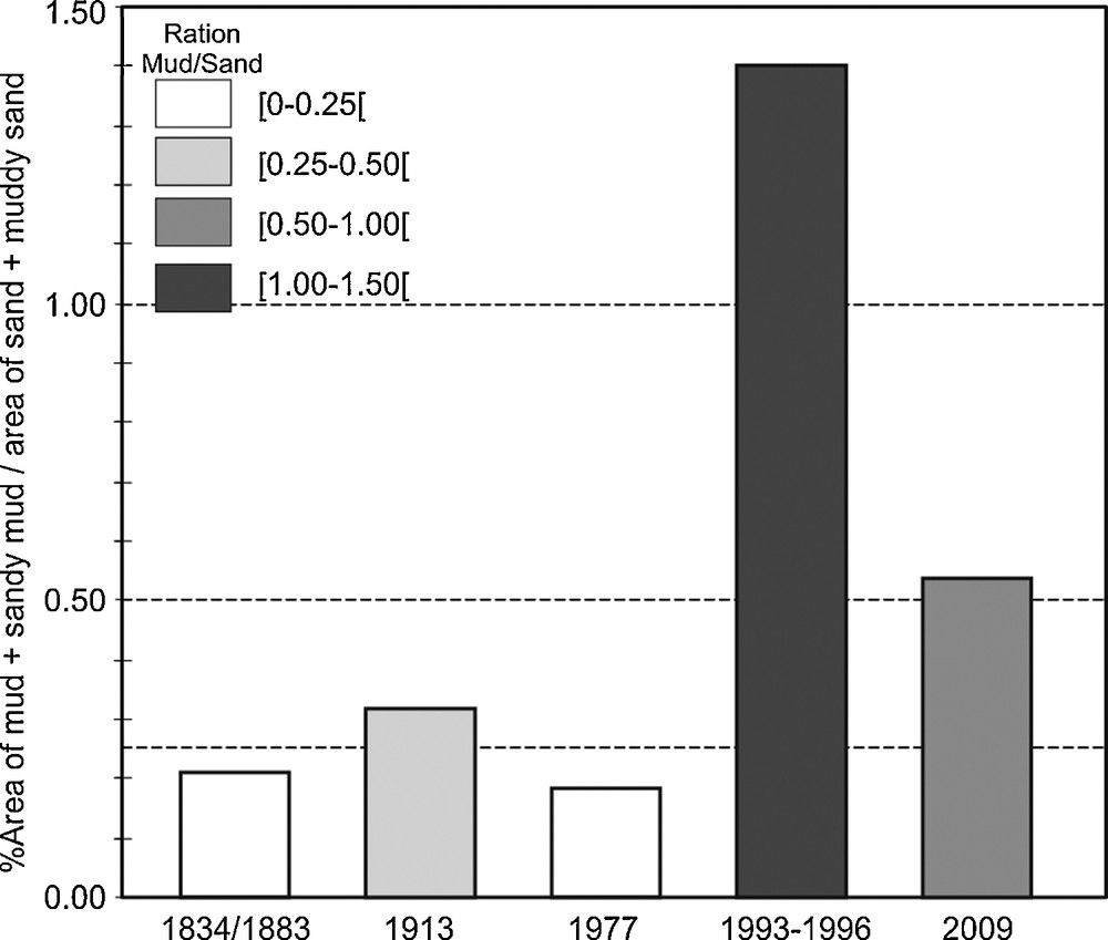
Ratio of muddy area (mud and sandy mud) to sandy area (sand and muddy sand), calculated for the 19th century, 1913, 1977, 1993–1996 and 2009, on a common area (red delimitation, Fig. 2).
The Seine River flows have been measured at the upper limit of the estuary from 1941 up to today (GIP Seine-Aval). During the end of the 1970s, flow rates were generally very low (Fig. 3), which could explain the remaining of sandy areas, even taking into account the fact that engineering work was already finished upstream before this period. For the years 1993–1996, periods of high flow rates occurred frequently, although 2009 data were collected after different conditions; superimposed on seasonal variations, long periods (about 9 years) of low river flows (when storage of fine-grained sediments occurred within the estuary) were disrupted by few and short periods of high river discharges (when mud supply increased in the downstream part of the estuary). Before and during years 1993–1996, flow rates were strong enough to displace the turbidity maximum downstream, to expel it from the navigation channel and to trigger a high sedimentation rate of mud into the mouth of the estuary. So, high supply of mud involved a deposition of thick layers of fine-grained sediment. Under these conditions, these deposits are then reworked and dispersed all over the estuary, according to seasonal variations, as described above. When supplies of estuarine fine-grained sediments are too weak, reworking processes by waves and tidal currents dominate. These other conditions lead to the mixing of the low quantity of mud with sands. This pattern was shown in the inner Bay of the Seine (Garnaud et al., 2002). The thin pebbles of very soft mud often observed nowadays are also a light version of fine-grained sedimentation process described for the years 1990s. The importance of high river flows versus tidal dynamics has also been described in other European estuaries (e.g., Blott et al., 2006; Mitchell et al., 2012; Thomas et al., 2002), Western Australian estuaries (Wolanski et al., 2001) or subtropical estuaries (Van Maren and Hoekstra, 2004; Wang et al., 2013).
The present-day distribution of sedimentary facies illustrates a spreading of fine-grained sediment, beyond former boundaries, but also on the seabed of the Bay of the Seine, where sediment had always been, until now, described as coarse sand or gravelly sand. The repartition of superficial sediment in 2009 looks like the repartition of facies in summer during the 1990s, i.e. after the reworking of the mud deposited during the previous winter conditions. The facies corresponding to 2009 are also the product of the long reworking of deposits of the previous years with moderate river flows. Such an observation suggesting a global erosion of the estuary are reinforced by other observations:
- • the presence of numerous shell fragments, characterizing strong reworking and sorting of sediment;
- • the presence of thixotropic sands, attesting to an unstable deposit;
- • the presence of outcrops of black, old (dozens of years) and very stiff mud, showing a striping of present-day sediments;
- • the presence of mud pebbles being eroded within the sediment;
- • the abundance of mud pebbles above the seabed, even if most of them are associated with dredging work in the navigation channel and dismantling of northern mudflat in the northern channel (Cuvilliez et al., 2009).
The Seine estuary is a naturally tide-dominated estuary, according to the classification of Dalrymple et al. (1992); however, engineering activities, including building of embankments and dikes, have induced the infilling of lateral areas, the strong reduction of the available amount of space and has led to a downstream shift of the sedimentation area and increased the energy of the channelized river. Nevertheless, nowadays, the role of the river has increased and its consequence is an expelling of the TM and high mud supply in the mouth of the Seine estuary. Due to the expelling of TM, the beaches of the Bay of the Seine are distal parts of the Seine estuarine system (Dubrulle et al., 2007). When the river flows are high for long enough, they provide mud supply and deposition every winter, and especially during the first major high flow event. When the river flows are low, mud supply remains weak, and reworking by waves and tidal currents dominates. Then, the superficial sedimentation is also characterized by erosional features, including mixing of sand and mud, mud pebble production, sorting of sediments.
We point out the fact that it is difficult to identify the influence of man-made versus natural influence on the sedimentology. All the studies (e.g., Avoine et al., 1981) on long-term evolution of morphological characteristics have shown that anthropogenic effects are dominant on natural evolution. Further work is needed to clearly determine the influence of construction work and dredging versus hydrological influence alone on the distribution of sediment types, but a first approach is to consider maintenance dredging as a background noise on sedimentation.
6 Conclusion
The classification of superficial sediment is an effective indicator to monitor the evolution of an estuary from a morphosedimentological point of view. Prior to 1977 studies, the Seine estuary was globally made of sands, as commonly described in natural estuaries under temperate climate. By comparison with this former situation, in 1996, a shifting to a mud-dominated sedimentation was described. This evolution was explained by the modification of river flow rate dynamics induced by new engineering works (dikes and dredging) in the navigation channel that had increased the power of winter river flow rates, increasing the expelling and deposition of the turbidity maximum in the mouth of the estuary. According to the most recent sampling campaign (2009), data show an obvious reduction of the total surface of mud facies area, balanced by a large spreading of fine-grained (silt and clay) sedimentation over the whole Seine estuary mouth and an increase in the silt and clay content in the proximal marine sandy deposit, suggesting an “intra-sedimentary silting”.
During the three described periods, the hydrological conditions were different: low river flow rates in the 1977 study, medium to high flow rates for the 1993–1996 study, long period of low flow rates in the recent study of 2009. When the flow rate is high and long enough (usually each year), mud dominates over the mouth. On the contrary, when the dynamic of tide and swell is not dominated by flow rate power, estuary recovers a tide-dominated sedimentary dynamics, involving a dispersal of mud, even if the silt and clay fraction in the sand remains high. The importance of river flow rate in the sediment dynamics appears also very significant, even dominant since muddy feature of superficial sedimentation is controlled by the presence/absence of significant flow rates.
The Seine estuary is a good example of a man-altered estuary, since the respective influence of the three main hydrodynamic parameters (flow rate, tide and swell) have been modified. Modifications of morphology induce modifications of sedimentary dynamics, in a proportion that the sedimentation in the mouth of the estuary is now mainly influenced by river flows, as a prevalent long-term signal on tidal currents, even in a megatidal context. Considering the fine-grained fraction in the superficial sediments and its variations along the last 150 years, the Seine estuary has shifted from a tide-dominated to a river-dominated system.