

1 Introduction
Most of the catchment hydrological studies are based on hydrograph separation techniques to identify the principal source components of flow, using chemical tracers (including electrical conductivity) or isotopic tracers (mainly stable isotopes of the water molecule) applying two-component mixing models implying precipitation and water previously stored in the catchment before the event (e.g., Buttle, 1994; Genereux and Hooper, 1998). The limitations of two-component models have led in tests to extend hydrograph separation to three or more components mixing models (e.g., Burns et al., 2001; DeWalle et al., 1988; Klaus and McDonnell, 2013). Nevertheless, tracer-based hydrograph separation approaches may not be practical and economic in the long term as they require a lot of data about chemical/isotopic and discharge variability (Gonzales et al., 2009; Joerin et al., 2002), the latter being often a highly limiting parameter.
In this context, since the 80s, combined geochemical tracers such as major and trace elements and radiogenic isotopes are used in river studies especially to constrain water origins, chemical (water–rock interaction) and physical (particulate transport) erosion processes (e.g., Allègre et al., 1996; Blum et al., 1994; Dupré et al., 1996; Gaillardet et al., 1997; Hagedorn et al., 2011; Harker et al., 2015; Kyser et al., 2015; Louvat and Allègre, 1997; Négrel et al., 2007; Paces and Wurster, 2014; Quade et al., 2003; Shand et al., 2009; Stallard and Edmond, 1983). These studies essentially dealt with large-scale watersheds, dominated by silicate lithologies. Only a few approaches focused on small watersheds (Aubert et al., 2001; Négrel and Deschamps, 1996; Négrel et al., 2004, 2015; Paul et al., 2015; Petelet-Giraud et al., 2003a; Pierret et al., 2014; Riotte and Chabaux, 1999; Schaffhauser et al., 2014; Viers et al., 2000) and even more in carbonated environments (Ben Othman et al., 1997; Brenot et al., 2008; Calmels et al., 2014; Négrel and Petelet-Giraud, 2005; Petelet et al., 1998; Petelet-Giraud et al., 2003b).
These chemical and isotopic technics were only rarely applied to help in the delineation of water source areas during flood events (Ben Othman et al., 1997; Négrel and Petelet-Giraud, 2005; Petelet-Giraud and Négrel, 2007; Rai and Singh, 2007). Petelet-Giraud and Négrel (2007) and Petelet-Giraud et al. (2015) applied a combined chemical and isotopic approach to perform flood deconvolutions in a Mediterranean catchment (Hérault, France) using Sr isotopes, major and trace element concentrations. They demonstrated the ability of these tracers to define very well constrained end-member (characterized under various hydrological conditions) for each tributary as the result of the diversity of the drained lithologies. A monitoring at the outlet of the watershed during low flow periods shows that the signature results from a binary mixing between the two main water sources in the basin (the main tributary and groundwater from karstic system of the basin). During 4 flood events, they showed that each of them presents a different temporal geochemical evolution (counter- or clockwise evolution in an 87Sr/86Sr vs. 1/Sr diagram) reflecting temporal changes in the predominant water source during the flood, i.e., the various tributaries versus the karst aquifers depending on rainfall intensity, duration and location. At this medium scale study (2500 km2), it was not possible to go deep in the understanding of small-scale water source patterns, i.e. the contributing water reservoirs in each sub-basin as a response to rain events. Therefore, to go further, this study focuses on one of the Hérault tributaries, the Peyne River and especially regarding two sub-basins with a very small area (6 to 16 km2) using the approach based on major and trace element concentrations and Sr isotopes tracers. We present the results of three sampling campaigns in contrasted hydrological conditions (high and low flows). The objectives are: (1) to test the ability of chemical and isotopic tracers to trace the sources of water by linking back the measured geochemical signatures in small brooks to the drained lithologies; (2) to investigate the chemical and isotopic signals at the outlet of the Peyne River that integrates water runoff from the small-scale sub-basins and (3) to attempt demonstrating the feasibility of this approach to define the main compartments contributing to the river discharge.
2 Study area description
The Peyne watershed covers 120 km2, in the South of France, being a sub-basin of the Hérault watershed. The climate is typically Mediterranean i.e. characterized by a great irregularity of rainfall regime. The mean annual precipitations are about 700 mm and the precipitation events are often short but very intensive, inducing flash floods and often destructive (Ribolzi et al., 1996). The Peyne River is fed by five small tributaries in its lower part (Fig. 1). The Olivettes dam, located at the limit between the upper and lower part of the basin, controls the discharge downstream. During summer, the dam releases between 50 and 150 L·s−1, which constitutes the quasi-totality of the downstream Peyne River discharge. The lower part of the watershed is mainly covered by vineyards, with a geology mainly represented by Triassic, Miocene and Pliocene marine, lacustrine and fluvial deposits. The study focuses on two hydrologically independent and distinct parts of the lower basin, namely the St Martial and La Lande–La Prade basins.
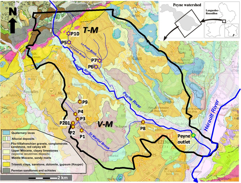
Geological map of the lower part of the Peyne watershed and the sample location in both studied sub-basins: The V–M compartment is mainly composed of Plio-Villafranchian gravels and Miocene sandy marls. The T–M compartment is mainly composed of Triassic gypsiferous marls and dolomites and Miocene sandy marls). The geological map is from www.infoterre.brgm.fr.
The St Martial basin covers 16.2 km2 (Fig. 1), is located in the southern part of the Peyne basin and is mainly composed of continental Pliocene-Villafranchian gravels, Miocene sandy marls with limestones and clays (hereafter referenced as V–M). This sub-basin is drained by the St Martial brook, 10.5 km long. The La Lande–La Prade basin covers ∼6 km2 (Fig. 1), it is located in the northern part of the basin, and is mainly composed of Triassic gypsiferous marls together with dolomites and Miocene sandy marls (hereafter referenced as T–M).
These two sub-basins were selected because they drain relatively simple and well constrained lithologies, and because of their common Miocene formations downstream allowing further comparison of the water geochemical signatures.
3 Sampling and analytical methods
Three sampling campaigns were performed between November 1996 and November 1997, reflecting different hydrological conditions from low flow periods (November 1996) to high flow periods (Nov-97, right after a heavy rainy episode), together with an intermediate situation (low-medium flow in February 1997), Fig. 2A. Between 5 and 8 samples were collected in the V–M compartment according to the flow regime, upstream lateral contributors to the St Martial brook were dry in low flow. In The T–M compartment 3 samples were taken in low flows and 4 in higher regime for the same reason (Table 1).
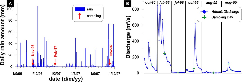
(A) Daily rainfall in Pezenas (outlet out the Peyne watershed) over the studied period. Red arrows mark the sampling dates (13/11/1996: low flow; 25/02/1997: low-medium flow; 8/11/1997: high flow). (B) Discharge at the outlet of the Hérault River at the sampling periods at the outlet of the Peyne watershed (data are from www.hydro.eaufrance.fr).
Major, trace elements concentration and Sr isotopic composition in the dissolved load of the Peyne watershed water samples.
| Number | Compartment | pH | EC | Ca2+ | Mg2+ | Na+ | K+ | Cl- | SO42- | Sr | 87Sr/86Sr |
| (μS/cm) | (μmol/L) | (μmol/L) | |||||||||
| Low flows (November 1996) | |||||||||||
| P1 | V-M | 7.52 | 1400 | 6.73 | 0.90 | 1.13 | 0.01 | 3.90 | 2.64 | 5.05 | 0.71140 |
| P2 | V-M | 7.49 | 1190 | 5.81 | 0.50 | 0.85 | d.l. | 3.28 | 1.87 | 4.06 | 0.71134 |
| P3 | V-M | 7.21 | 1210 | 5.86 | 0.51 | 1.32 | 0.08 | 2.79 | 1.94 | 3.34 | 0.71116 |
| P4 | V-M | 7.05 | 1140 | 4.99 | 0.92 | 1.38 | 0.03 | 2.63 | 1.98 | 2.97 | 0.71185 |
| P8 | V-M | 7.88 | 850 | 3.78 | 0.56 | 0.90 | 0.07 | 1.70 | 0.99 | 3.03 | 0.70828 |
| P5 | T-M | 7.33 | 1790 | 7.85 | 3.52 | 1.01 | 0.06 | 2.32 | 7.46 | 44.16 | 0.70844 |
| P6 | T-M | 7.46 | 1260 | 5.23 | 1.54 | 0.97 | 0.09 | 2.26 | 2.89 | 11.46 | 0.70886 |
| P7 | T-M | 7.74 | 2160 | 9.01 | 3.23 | 2.77 | 0.14 | 6.49 | 8.34 | 14.72 | 0.70910 |
| Low–medium flows (February 1997) | |||||||||||
| P1 | V-M | 7.39 | 1070 | 5.46 | 0.56 | 1.06 | 0.16 | 2.88 | 1.93 | 3.44 | 0.71137 |
| P2 | V-M | 7.19 | 1160 | 6.01 | 0.58 | 1.08 | 0.18 | 3.32 | 1.96 | 4.06 | 0.71146 |
| P3 | V-M | 7.54 | 1010 | 5.12 | 0.47 | 1.19 | 0.23 | 2.49 | 1.81 | 2.98 | – |
| P4 | V-M | 7.16 | 1120 | 5.46 | 0.53 | 1.39 | 0.21 | 2.86 | 1.91 | 3.20 | – |
| P8 | V-M | 8.11 | 860 | 3.91 | 0.80 | 1.19 | 0.03 | 1.87 | 1.27 | 3.27 | 0.70846 |
| P9 | V-M | 7.03 | 940 | 5.03 | 0.38 | 0.79 | d.l. | 2.43 | 1.66 | 1.84 | 0.71124 |
| P201 | V-M | 6.7 | 1250 | 7.11 | 0.68 | 1.06 | d.l. | 3.60 | 2.25 | 4.36 | 0.71139 |
| P5 | T-M | 7.41 | 1770 | 7.95 | 3.70 | 1.11 | 0.09 | 1.98 | 8.97 | 40.50 | 0.70854 |
| P6 | T-M | 7.66 | 1340 | 5.52 | 2.29 | 1.13 | 0.03 | 2.45 | 4.88 | 18.60 | 0.70868 |
| P7 | T-M | 7.75 | 2070 | 8.31 | 3.80 | 3.31 | 0.05 | 6.14 | 8.22 | 12.92 | 0.70922 |
| P10 | T-M | 7.85 | 1650 | 7.38 | 3.80 | 1.03 | 0.16 | 1.78 | 9.29 | 35.74 | 0.70866 |
| High flows (November 1997) | |||||||||||
| P1 | V-M | 7.68 | 1368 | 7.25 | 0.86 | 1.73 | 0.01 | 4.13 | 3.39 | 4.47 | – |
| P2 | V-M | 7.63 | 1156 | 6.02 | 0.67 | 1.33 | 0.02 | 3.28 | 2.34 | 3.77 | – |
| P2a | V-M | 7.27 | 1100 | 6.39 | 0.73 | 1.39 | d.l. | 3.47 | 2.38 | 4.02 | – |
| P3 | V-M | 7.74 | 1129 | 5.85 | 0.71 | 1.77 | 0.03 | 2.94 | 2.64 | 3.14 | – |
| P4 | V-M | 7.61 | 680 | 3.06 | 0.35 | 0.81 | 0.14 | 0.98 | 1.20 | 1.72 | – |
| P8 | V-M | 8.07 | 888 | 4.06 | 0.77 | 1.96 | 0.55 | 1.94 | 1.43 | 3.05 | – |
| P9 | V-M | 7.75 | 665 | 3.76 | 0.18 | 0.86 | 0.01 | 1.18 | 1.11 | 1.30 | – |
| P201 | V-M | 7.3 | 1190 | 6.65 | 0.80 | 1.45 | 0.01 | 3.25 | 2.26 | 4.07 | – |
| P5 | T-M | 7.41 | 1800 | 8.46 | 3.83 | 1.28 | 0.02 | 1.96 | 9.58 | 41.09 | – |
| P6 | T-M | 7.5 | 1162 | 5.03 | 1.78 | 1.25 | d.l. | 2.07 | 3.91 | 13.35 | – |
| P7 | T-M | 7.86 | 1732 | 7.13 | 2.13 | 1.92 | 0.03 | 4.54 | 7.01 | 11.76 | – |
| P10 | T-M | 7.81 | 1626 | 7.38 | 3.13 | 0.99 | 0.13 | 1.56 | 9.06 | 29.33 | – |
Water temperature and electric conductivity were measured on site with a microprocessor conductivity-meter WTW LF96 standardised at 25 °C. The pH was also measured on site using an Ingold electrode and an Orion 250 pH-meter. The samples for trace element and Sr isotope determinations were collected in acid-cleaned polypropylene bottles. Samples were filtered, through acid-cleaned 0.2 μm PVDF filters, less than six hours after collection (Goldstein and Jacobsen, 1987). An aliquot was stored before acidification for anion analyses. Filtered samples were acidified to pH 2 with sub-boiled 15 N HNO3 and stored at 4 °C in the dark until analysis. Major elements were analysed by Capillary Ion Electrophoresis (accuracy 5%). Trace element concentrations were determined by ICP-MS (VG® Plasma Quad PQ2 Turbo Plus). For isotopic analyses, Sr was separated on a Biorad® (AG50 X8 200–400 mesh) resin column in HCl media (Birck, 1986) and analysed on a VG Sector Mass Spectrometer. The mean value of the NBS 987 Sr standard over this period was 87Sr/86Sr = 0.71024 ± 0.00004 (n = 23, 2 σn).
4 Results and discussion
4.1 The geochemical composition of the Peyne Basin waters
Electrical Conductivity (EC), pH, major elements, Sr concentrations and Sr isotopic compositions are listed in Table 1.
The EC varies from 670 to 2160 μS/cm. The highest mineralized waters are observed in brooks with the smallest discharge and draining Triassic and Miocene formations (T–M compartment). Part of the mineralization could be related to the anthropogenic activities (mainly vineyard exploitation) but the water–rock interactions must be dominant as the headwaters of this compartment, draining an uncultivated and non-urbanized area, present a Total Dissolved Solids (TDS) around 1.5 g·L−1 during both high and low flow periods. In the V–M compartment, the EC decreases progressively from P4 to P8 despite of the mineralized lateral contributions (P1, P2). Waters from the T–M compartment are characterized by a Ca-SO4 facies due to the drainage of the Triassic formations, especially the gypsiferous marls. In contrast, the V–M compartment presents mainly Ca–HCO3 water types.
Major element ratios between alkali and alkali-earth are recognized to be tracers of drained lithologies, especially adapted for discrimination of silicated versus carbonated rocks (e.g., Gaillardet et al., 1999; Meybeck, 1986; Négrel et al., 1993, 2013; Stallard and Edmond, 1983). In this perspective, by plotting the sampled waters in an Mg/Na vs. Ca/Na diagram (Fig. 3), two geochemical trends may be delineated. These two patterns initiate from a common end-member featured by low Ca/Na (∼1–2) and low Mg/Na (∼0.5–1) molar ratios, which reflects a mixed influence of silicate and carbonate rock weathering (EM-1) according to literature data (Gaillardet et al., 1999; Meybeck, 1986 and references therein). Samples draining the V–M compartment present low Mg/Na ratios and relatively large variations of the Ca/Na ratio. The high Ca/Na ratios (up to 7) define the second end-member (EM-2) that tends towards typical values of water draining carbonates. Samples originating from the T–M compartment define a third end-member (EM-3) with Ca/Na ∼ 8 and Mg/Na ∼ 4 that tends towards typical values of water draining carbonates and dolomites (Gaillardet et al., 1999; Meybeck, 1986). Finally, the Peyne River samples, sampled at the outlet of the watershed, plots next to EM-1 that corresponds to a mixed influence of silicate and carbonate, reflecting that the Peyne River integrates and mixes water draining various lithologies whatever the hydrologic conditions. At this stage, based on major elements concentrations, the three end-members cannot be precisely defined as we cannot yet identify exactly which facies impose their geochemical signatures. This will be investigated further using Sr isotopes.
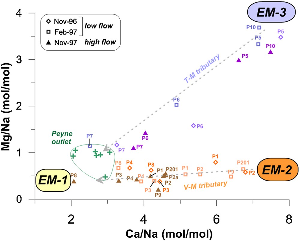
Mg/Na vs. Ca/Na diagram (molar ratios) of the Peyne watershed samples. The theoretical local end-members are reported as EM-1 to EM-3 (see text). The Peyne River samples at the outlet of the basin are from this study and Petelet-Giraud and Négrel (2007) and references therein.
4.2 The Sr isotopic composition of the Peyne Basin waters
Sr isotopes are a powerful tool to discriminate the drained lithologies and water circulations. Indeed, the Sr isotopic ratio (87Sr/86Sr) reflects the type of rocks or minerals being weathered. The so-called radiogenic 87Sr/86Sr, generally higher than 0.710, are observed in waters draining silicates and associated with low Sr concentrations (Aubert et al., 2002; Blum et al., 1994; Petelet-Giraud et al., 2003b). Waters presenting lower 87Sr/86Sr ratios, generally close to 0.708–0.709, with high Sr contents reflect the drainage of carbonates (Albarède and Michard, 1987; Edmond, 1992; Goldstein and Jacobsen, 1987; Petelet-Giraud et al., 2003a; Semhi et al., 2000). Their Sr isotopic compositions is generally related to the Sr isotopic characteristics of the sea water at the time of carbonate deposition (Burke et al., 1982; Koepnick et al., 1985; Koepnick et al., 1990; Palmer and Elderfield, 1985).
In the T–M compartment 87Sr/86Sr ratios vary between 0.70844 and 0.70922 (Fig. 4). In the upper part, samples P10 and P5 present relatively low 87Sr/86Sr around 0.7085 that preclude a significant contribution from the Permian and Triassic sandstones of the head of the T–M compartment. This Sr isotopic signature tends towards the Triassic carbonate fingerprints (87Sr/86Sr = 0.7074 to 0.7082; e.g., Korte et al., 2003) and more specifically towards the Triassic gypsum as measured on rocks samples in the Var valley (South East of France, Potot et al., 2012), in agreement with the Ca-SO4 water type evidenced for these samples. Water sampled in P7 (87Sr/86Sr ∼ 0.70915), only drains the Miocene sandy marls formations from the middle part of the Peyne watershed, and thus can be considered as representative of this Miocene lithology. Downstream, P6 receives water from P10 and P5 and drains the Miocene sandy marls (like P7), P6 presents an intermediate signature between P5P10 and P7.
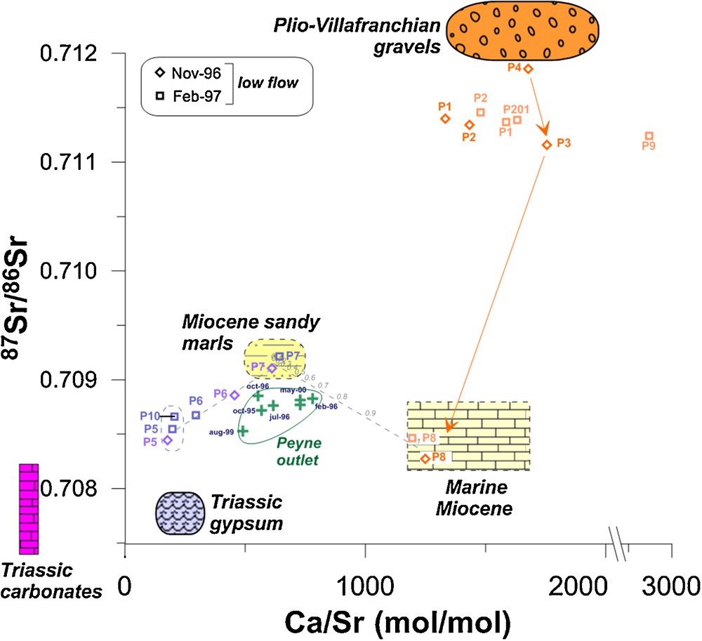
87Sr/86Sr vs. Ca/Sr diagram. The lithologic end-members discriminated with the 87Sr/86Sr isotopic ratios are also plotted. Marine Miocene end-member is from Hodell et al. (1991) and Schildgen et al. (2014), the Triassic carbonates end-member from Korte et al. (2003), and the Triassic gypsum from Potot et al. (2012).
In the Saint-Martial basin (V–M), 87Sr/86Sr ratios present much variation, ranging from 0.70827 to 0.71185, the highest values higher than 0.711 being observed in the headwaters where water originates from the Villafranchian gravel formation mainly composed of quartz and terrigenous detritic material. This later detritic material probably imposes its relatively radiogenic signature (Fig. 4). At the outlet of the V–M area, the sample P8 presents a lower 87Sr/86Sr signature (∼0.7085), much less radiogenic than the signature of the Miocene sandy marls. This low 87Sr/86Sr could reflect the drainage of the Late Miocene formation outcropping downstream in the sub-basin. This formation is composed of limestone with a smaller detritic fraction than the underlying Middle Miocene one (constituting the main outcropping facies), resulting in a less radiogenic Sr isotopic composition. Consistently, pure marine Miocene carbonates have 87Sr/86Sr usually ranging between 0.7083 and 0.7089 (Hodell et al., 1991; Schildgen et al., 2014) and the local Miocene carbonates in the Vène catchment, 25 km eastward the studied area, show a 87Sr/86Sr of 0.70877 (Ben Othman et al., 1997), compatible with the measured values in P8. In addition, the Ca/Sr ∼1200 of P8 are fully in agreement with the range defined for small or large rivers draining carbonates (1200–1700; Ben Othman et al., 1997; Négrel et al., 1993; Petelet et al., 1998).
Therefore, these results show that Sr isotopes allow the nature of the end-members to be tightly constrained, especially through to the discrimination of the two distinct Miocene layers, i.e. the Middle Miocene sandy marls defining the dominant outcropping facies in the middle part of the basin and the Late Miocene limestone outcropping in the low part of the basin.
4.3 End-member contribution during different hydrological conditions
The Peyne River was sampled seven times at the outlet of the watershed (Petelet-Giraud and Négrel, 2007), i.e. where it collects all the waters from the watershed (VM and TM compartments). The Peyne being an ungauged river, the general hydrological conditions at the various sampling periods may be illustrated using the neighboring next order Hérault River discharge at its outlet (Fig. 2B). Two extreme hydrological conditions are represented by the sample of February 1996, collected during the decreasing phase of a big flood, and the sample of August 1999, collected during the summer minimum flow. Data of the Peyne River outlet are reported in Fig. 4, where they present a limited range of variation both for their Ca/Sr ratio (490–780) and 87Sr/86Sr (0.70852–0.70885) compared to the signatures of the main end-members identified in the Peyne watershed. This implies that, at the scale of the Peyne watershed (70 km2), despite the great variability of signature highlighted in the contributing compartments, the geochemical signatures observed in the Peyne river are relatively buffered whatever the hydrological conditions. In addition, these signatures preclude significant contributions from the upper deposit layers composed of the more radiogenic Plio-Villafranchian gravels, sandstones and red clays. Data plot in a ternary mixing diagram whose end-members are defined by (1) Miocene sandy marls, (2) marine Miocene and (3) Triassic carbonates and gypsum. In high flow conditions (February 1996), the Peyne outlet presents a signature mainly marked by the Miocene end-members, both Middle and upper facies. In minimum flow conditions (August 1999), the Peyne outlet presents the lowest Ca/Sr ratio together with the lower 87Sr/86Sr ratios and tends towards the Triassic signature. It thus seems that during minimum flow period, the imprint of the highly mineralized water draining the gypsiferous facies is still visible at the outlet of the Peyne, while in high flow conditions the Miocene signature clearly dominates. Considering a simple binary mixing between the 2 Miocene formations (represented by P7 and P8), the sample of the Peyne outlet in February 1996 would correspond to the mixing of water draining both Miocene formations with about 70% coming from the Upper Miocene reservoir and 30% from the Middle Miocene terrains.
5 Conclusion
This study presents the ability of major and trace element concentrations together with 87Sr/86Sr isotope ratios to trace water origins in river basin at very small scale and to explain the geochemical and isotopic signal at the outlet of a small ungauged watershed. Two small and hydrologically independent sub-basins of the lower Peyne watershed (70 km2) were selected because they drain distinct lithologies (Plio-Villafranchian conglomerate versus Triassic gypsum-rich marls and dolomites) in their headwater and Miocene formations downstream. These small brooks were sampled in several locations along their courses together with small lateral contributions supposed to drain monolithologic units. This approach highlights that:
- (1) major elements concentrations and Ca/Na vs. Mg/Na ratios classically applied to distinguish carbonate from silicate weathering, allow discriminating three main end-members from the two sub-basins;
87Sr/86Sr isotope ratios, coupled with Ca/Sr ratios, discriminate more precisely the drained lithologies of the two sub-basins. Firstly, the 87Sr/86Sr ratios allow identifying the nature of the lithologies and their main component(s) contributing to the Sr budget in water. Secondly, Sr isotopes evidenced two distinct Miocene facies: the detritic fraction with the sandy marls, and the marine carbonates;
- (2) the geochemical signatures of the Peyne River itself, sampled at the outlet of the watershed just before the confluence into the Hérault River, was compared with the above-described tributary samples. It appears that the signature of the Peyne River, integrating all the water draining the basin, is relatively invariant whatever the hydrological conditions and mainly marked by the Miocene formations. The Sr isotopes highlight the role of Miocene facies present in the lower part of the Peyne watershed, i.e. the sandy marls and the carbonates in the signature of the river, and evidence that the typical signature of the Plio-Villafranchian conglomerates is completely hidden. The Triassic gypsiferous marls and dolomites of the headwaters of the T–M sub-basin seem to imprint their signature only during the minimum flow period; this could be related to the high solubility of the gypsum formations releasing large quantities of dissolved elements in solution, even if the contribution to the river discharge from this part of the basin is very limited.
These results illustrate that the geochemical tracers (major, trace elements and Sr isotopes) are extremely dependent on the facies sequences (morphology) and of the soil nature (mineralogical composition), what is particularly a varying feature at small scale, making them relevant tools to trace water origins in rivers, i.e. identify the contributing compartments of the basin. Although only based on a very limited number of samples, this study allows roughly defining the contributing compartments to the discharge at the outlet of the basin. Nevertheless, in the objective to clearly identify the water origins during flood events, dedicated sampling campaigns should be conducted during several floods episodes.
In Mediterranean Europe, flash floods are classified as one of the most devastating hazards in terms of human life loss and infrastructures (Gruntfest and Handmer, 1999); e.g., Southern France has paid a heavy toll because of floods over the last 25 years (> 20 victims). In the Mediterranean area, some hydrograph deconvolution studies using geochemical tracers were conducted (e.g., Marc et al., 1995; Ribolzi et al., 1996, 1997), but they are limited to very small experimental research basins, studied in detail and equipped with real-time monitoring of rain and discharge. Furthermore, classical hydrological techniques for flood real-time monitoring and flood forecast are mainly implemented in large rivers and upstream heavily populated areas or of major economic interest, whereas flash floods often happen in small ungauged catchments (Borga et al., 2008). Therefore, this kind of presented geochemical approach, including isotopic fingerprinting, should be considered as a potential alternative to delineate the main contributing areas during floods, especially in small ungauged river basins.