


 CC-BY 4.0
1. Introduction
The Comoros Archipelago, in the Mozambique Channel between east Africa and northern Madagascar (Figure 1), is located along the poorly constrained plate boundary between the Lwandle and Somalia lithospheric plates [Famin et al. 2020; Kusky et al. 2010; Stamps et al. 2018, 2021]. This boundary has probably evolved jointly with the southward propagation of the East African Rift System (EARS) [e.g., Franke et al. 2015; Mougenot et al. 1986].
(a) Regional geological context of the study area. Volcanism in the northern Mozambique Channel from Michon et al. [2022] and Roche and Ringenbach [2022]. Earthquake locations from the database of the ISC [2021]; plate boundaries from Michon et al. [2022]; fracture zones from Davis et al. [2016]; boundary of oceanic crust and exhumed mantle (COB) from Roche and Ringenbach [2022]; major faults of the East African Rift System (heavy black lines) from Michon et al. [2022]; bathymetry from GEBCO, 2014 [Weatherall et al. 2015]. A, Ambilobe basin; DR, Davie Ridge; K, Kerimbas basin; M, Majumba basin; N, Nacada basin. (b) Focal mechanisms compilation [Bertil et al. 2021, and references therein] and present-day relative plate motions with respect to Nubia plate [Stamps et al. 2021].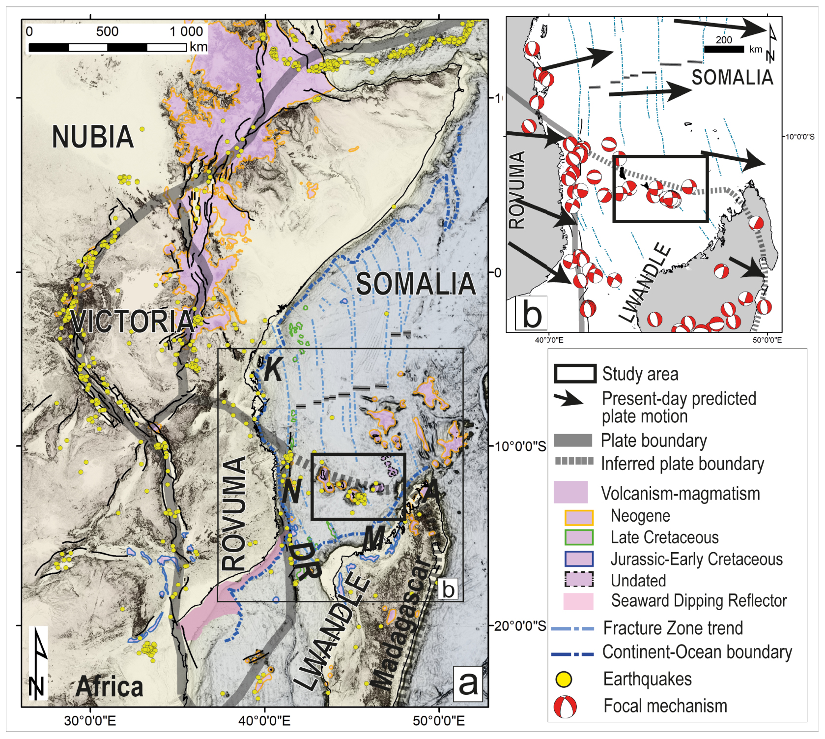
Seismicity in the Mozambique Channel is of moderate intensity and is concentrated along two large-scale structures: Davie Ridge and the Comoros Archipelago [Bertil and Regnoult 1998; Bertil et al. 2021; Lemoine et al. 2020; Figure 1]. Focal mechanisms mainly indicate regional E–W extension along Davie Ridge, considered to be a N–S trending offshore arm of the EARS [Courgeon et al. 2018; Déprez et al. 2013; Deville et al. 2018]. West of the Comoros Archipelago, sparse focal mechanisms along approximately N–S trending normal faults are also compatible with E–W extension and may be related to the EARS [e.g., Klimke and Franke 2016]. In contrast, seismicity in the Comoros Archipelago indicates ESE–WNW distribution west of Mayotte and ENE–WSW distribution east of Mayotte [Bertil et al. 2021]. Elsewhere in the Archipelago, sparse focal mechanisms suggest mainly strike-slip faulting with a normal component, including the seismo-volcanic sequence associated with the 2018–2021 East Mayotte eruption [Cesca et al. 2020; Feuillet et al. 2021; Lemoine et al. 2020; Lavayssière et al. 2022; Mercury et al. 2022]. Holocene tectonic and volcanic activity is also evident on the islands of Anjouan and Mayotte [Famin et al. 2020; Quidelleur et al. 2022] and in the abyssal plain north of the Archipelago [Tzevahirtzian et al. 2021]. Recent studies [e.g., Bertil et al. 2021; Famin et al. 2020; Feuillet et al. 2021; Kusky et al. 2010; Lemoine et al. 2020; Michon 2016; Stamps et al. 2018, 2021] have suggested that the Comoros Archipelago is located along a diffuse or incipient plate boundary between the Lwandle and Somalia plates, although the sense of displacement is poorly constrained, being consistent with transtension, pure strike-slip, or transpression.
Early work has focused on the Comoro Islands, and few papers have treated the offshore parts of the Archipelago (Figure 2). Using bathymetric data, Audru et al. [2006] and Tzevahirtzian et al. [2021] provide overviews of the volcanic structures and slope instabilities on the flanks of the islands. Since 2019, Mayotte Volcanological And Seismological Monitoring Network [REVOSIMA 2019–2022] has closely monitored the ongoing seismo-volcanic events and reported detailed information, such as seafloor morphology and seismic and volcanic activity on the eastern slope of Mayotte, where ∼6.55 km3 of magma erupted in January 2021), as well as the lithology of volcanic structures [e.g., Berthod et al. 2021a, b; Deplus et al. 2019; Feuillet et al. 2021; Foix et al. 2021; Jacques et al. 2019; Lavayssière et al. 2022; REVOSIMA newsletter 2021; Saurel et al. 2022]. Yet, the age and nature of the volcanic Comoros Archipelago and surrounding areas are constrained only by analysis of onshore samples [Class et al. 2005; Michon 2016; Pelleter et al. 2014; Quidelleur et al. 2022] and rare marine rock samples, mostly from east of Mayotte [Berthod et al. 2021a, b; Feuillet et al. 2021].
Map of major geographic features of the study area and data acquired during the 2020–2021 SISMAORE cruise. SBP, sub-bottom profiler lines; thin lines, SISRAP, 48-channel seismic reflection; Multichannel seismic (MCS) data, 960-channel seismic reflection Masquelet et al. [2022]; OBS, ocean bottom seismometer. Multibeam echosounder system (MBES) and water column acoustic data were obtained along all black lines Thinon et al. [2020a]. Volcanic islands: GC, Grande-Comore; Mo, Mohéli; A, Anjouan; Ma, Mayotte. Major seamounts and chains: V, Vailheu; J, Jumelles; Z, Zélée Bank; G, Geyser Bank; L, Leven Bank; C, Cordelière Bank. White stars: K, Karthala volcano; FMV, Fani Maore volcano; FaC, Fer à Cheval volcanic complex [Feuillet et al. 2021]. Detailed bathymetry from the compilation of Tzevahirtzian et al. [2021] (surveys listed in references and in Counts et al. [2018]) superimposed on GEBCO regional low-resolution bathymetry [Weatherall et al. 2015]. White outlines correspond to other figures in this paper.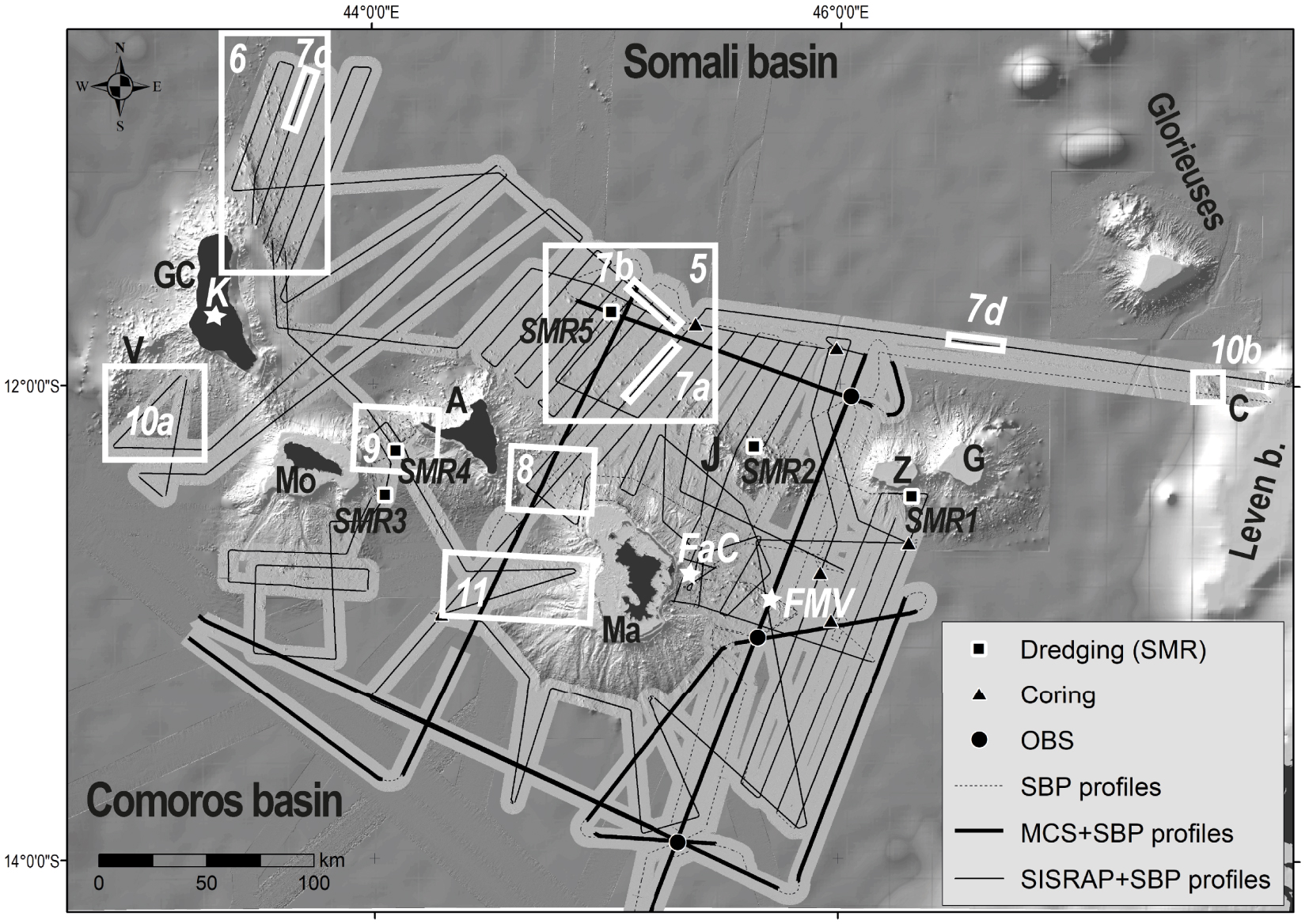
To fill this data gap, the geophysical and geological SISMAORE oceanographic cruise, linked to the COYOTES project (COmoros & maYotte: vOlcanism, TEctonics and Seismicity), took place off the Comoros Archipelago from December 2020 to February 2021 [Thinon et al. 2020a]. This cruise acquired high-resolution multibeam bathymetry and backscatter data, shallow and deep seismic reflection profiles and refraction data, heat flow, magnetic and gravity data, and rock and sediment samples. In this paper, we focus on the main characteristics of the recent volcanic and tectonic structures at a regional scale, to better map the distribution of deformation around the Archipelago. Better knowledge of active structures and their regional geodynamic context will improve the identification and assessment of regional volcanic, seismic, tsunamigenic, and landslide hazards. In this paper, we propose a geodynamic configuration that takes into account the pre-volcanism history of the northern Mozambique Channel and current regional kinematics.
2. Regional settings
2.1. Volcanism of the Comoros Archipelago
The Comoros Archipelago includes the four main islands, Grande-Comore, Mohéli, Anjouan and Mayotte, as well as submerged features including the Jumelles seamounts, Vailheu seamount and the Zélée–Geyser banks [e.g., Tzevahirtzian et al. 2021; Figure 2]. Seismic stratigraphy [Leroux et al. 2020] indicates that the main volcanic phase of Mayotte (late Paleogene to Neogene) is much younger than Zélée–Geyser banks (Cretaceous-Paleogene transition), which in turn are younger than the Glorieuses seamounts (Late Cretaceous). Mayotte, oldest of the four main islands, has a low elevation and a well-developed insular shelf, as does Mohéli [Tzevahirtzian et al. 2021]. The onset of Mayotte’s volcanism was estimated at about 20 Ma by Michon [2016] and between 26 and 27 Ma by Masquelet et al. [2022]. For Anjouan and Grande-Comore, high-elevation volcanic islands with young relief, volcanism could have started at 7 to 10 Ma [Michon 2016].
Subaerial Mayotte is made up of three morphologically and structurally distinct units corresponding to three eruptive phases, which date from 10.6 to 1.5 Ma in the south part, from 7.1 to 1.0 Ma in the northwest part and from 2.4 Ma to 0.15 Ma in the northeast part and the nearby islet Petite-Terre [Debeuf 2004; Nehlig et al. 2013]. Volcanic ash layers in dated lagoon sediments suggest that the most recent volcanic and explosive activity on land is younger than 7 ka [Zinke et al. 2003, 2005, and references therein]. On the northern slope off Mayotte, several small volcanic edifices are part of a longer line of volcanoes trending N140°E from Anjouan to Petite-Terre [Audru et al. 2006]. On the seafloor east of Mayotte, the MAYOBS monitoring cruises [Rinnert et al. 2019; REVOSIMA newsletter 2021] during the 2018–2021 Mayotte seismo-volcanic crisis have documented the N110°E trending Eastern Volcanic Chain of Mayotte (EVCM; Figure 2), a line of numerous volcanic structures with a new active volcanic edifice 800 m high and 5 km in diameter at its tip [Berthod et al. 2021a, b; Cesca et al. 2020; Feuillet et al. 2021; Lemoine et al. 2020]. This active submarine volcano is called Fani Maor’e volcano (name submitted to the UNESCO’s International Marine Chart Commission, Figure 2).
Before the 2018–2021 Mayotte eruption, the only volcano with known historic activity (since the early 18th century) is Karthala volcano on Grande-Comore [Bachèlery et al. 1995, 2016b]. Late Holocene activity (from 14C ages of 1300 ± 65 yr BP and 740 ± 130 yr BP) is known for La Grille volcano on Grande-Comore [Bachèlery and Coudray 1993; Bachèlery et al. 2016b], and early Holocene activity is known for Anjouan [14C ages of 8335 ± 50 yr BP; e.g., Quidelleur et al. 2022].
The origin of the volcanism of the Comoros Archipelago is debated [Michon 2016]. A mantle plume model, proposed mainly based on large-scale geomorphological arguments and scant early K–Ar dates, is inconsistent with the inferred dextral transtension between the Somalia and Lwandle plates [Calais et al. 2006; Stamps et al. 2018] and by geochronological data showing no clear age progression through the islands [Debeuf 2004; Quidelleur et al. 2022; Tzevahirtzian et al. 2021]. One alternative explanation is that the volcanism represents an offshore extension of the EARS to the east of Davie Ridge, possibly along a diffuse or incipient Somalia–Lwandle plate boundary [e.g., Deville et al. 2018 and references therein; Famin et al. 2020; Feuillet et al. 2021; Lemoine et al. 2020; Michon et al. 2022; Stamps et al. 2018].
2.2. Distribution of recent and old deformation
Deformation onshore on Mayotte took place predominantly on thrust and strike-slip faults consistent with the N135°E trend in earthquake focal mechanisms [Famin et al. 2020]. Offshore structures trending N130°E include the Jumelles volcanic chain and some alignments of volcanic cones, mounds and faults [e.g., Tzevahirtzian et al. 2021]. Moreover, Lemoine et al. [2020] and Feuillet et al. [2021] have suggested that the deep dyke feeding the current Mayotte eruption is oriented NW–SE, consistent with the context of transtension.
Toward Davie Ridge on the west side of Mozambique Channel, Neogene strike-slip and normal faults imply a transtensional component associated with volcanism [Franke et al. 2015; Roche and Ringenbach 2022]. Other than there and in associated basins such as the Kerimbas and Nacala basins [Courgeon et al. 2018; Mahanjane 2014; Mougenot et al. 1986; Roche and Ringenbach 2022; Vormann and Jokat 2021], no Quaternary deformation has been described in the Comoros basin or in the Majunga basin in the NW Madagascar margin (Figure 1).
2.3. Regional geological history—inheritance
Recent studies suggest that rifting of Gondwana began in late early to early Middle Jurassic time, ∼170 Ma to ∼185 Ma [Davis et al. 2016; Eagles and König 2008; Gaina et al. 2015; Leinweber and Jokat 2012; Mueller and Jokat 2019; Senkans et al. 2019]. However, precise dating is difficult given the poorly developed seafloor spreading anomalies from this time. North of the Comoros Archipelago, kinematic reconstructions [e.g., Davis et al. 2016] and limited gravity and magnetic data suggest that the Somali basin consists of oceanic crust with an extinct EW trending oceanic spreading axis and transform faults trending N–S to NW–SE [see Figures 4 and 8 in Davis et al. 2016 and Figures 5 and 9 in Phethean et al. 2016] (Figure 1). Seafloor spreading is thought to have begun during the Jurassic Magnetic Quiet Zone (∼166 Ma) and ceased at ∼120 Ma [Davis et al. 2016; Segoufin and Patriat 1980]. In Mozambique and Tanzania to the west, the breakup unconformity is of early Middle Jurassic (Aalenian) age [Fossum et al. 2021; Roche et al. 2021; Senkans et al. 2019]. The age and the nature of the crust beneath the Comoro Islands and the Comoros Basin are still debated. On the one hand, an oceanic crust is supported by isostatic data, magnetic and gravity anomalies, P-wave velocities, and seismic reflection data [Coffin and Rabinowitz 1987; Coffin et al. 1986; Klimke et al. 2016; Phethean et al. 2016; Roche and Ringenbach 2022; Talwani 1962; Vormann and Jokat 2021; Vormann et al. 2020]. On the other hand, the presence of quartzite inclusions in volcanic rocks and a massif of quartzite on Anjouan [Flower 1972; Flower and Strong 1969; Montaggioni and Nougier 1981; Quidelleur et al. 2022; Wright and Mccurry 1970] and low Vp∕Vs ratios [Dofal et al. 2021] suggest that the Archipelago is built on continental crust or at least upon a succession of continental sediments [Dofal et al. 2021; Roach et al. 2017]. In Figure 1, we choose to represent the crust as oceanic [Roche and Ringenbach 2022].
Whatever the nature of the crust, gravity data appear to indicate some relict structural segmentation of both continental and oceanic domains beneath the Comoros Archipelago. Both transforms and fracture zones [Davis et al. 2016; Phethean et al. 2016] could be pre-existing structures in the Comoros and Somali Basins (Figure 1) that have influenced later structures.
3. Dataset from SISMAORE cruise and methods
The SISMAORE cruise (December 2020 to February 2021) of R/V (Research Vessel) Pourquoi Pas? collected 80,000 km2 of multibeam bathymetry and backscatter data around the Comoros Archipelago with the vessel-mounted MultiBeam Echosounder System (MBES RESON 7150 at 12 or 24 kHz) that complemented previous surveys around Mayotte [Figure 2; Thinon et al. 2020a; for details, see Supplementary Information]. In addition, the ship acquired 10,000 km of sub-bottom profiler (SBP) data and 6730 km of 48-channel seismic reflection profiles (for details, see Supplementary Information), imaging the subsurface down to 0.1 s two-way travel time (TWT) with very high resolution and down to ∼3 s TWT below the seafloor, respectively. Five dredging operations (Figures 2 and 3) collected mainly volcanic rocks on the flanks of Zélée Bank (sample set SMR1), the Jumelles volcanic chain (SMR2), Mohéli (SMR3), the Chistwani volcanic chain (SMR4) and a seamount in the abyssal plain north of Mayotte (SMR5) [Thinon et al. 2020a]. These rocks are macroscopically similar to those described on land in the Comoro Islands [Bachèlery and Hémond 2016; Debeuf 2004; Pelleter et al. 2014, and references therein] and offshore of Mayotte [Berthod et al. 2021a, b]. The rocks in the SMR5 dredge samples are CO2-rich fresh basaltic rocks called popping rocks (Supplementary Figure S1) that contain arkose and quartzite xenoliths, occasionally with melted shapes, and rare olivine xenocrysts [Thinon et al. 2020a].
Maps showing (a) bathymetry and (b) acoustic backscatter imagery from the SISMAORE cruise combined with previous bathymetric data. Also shown are locations of newly described features: Vailheu, Domoni, Chistwani and Safari volcanic chains and N’Droundé and Mwezi provinces. Yellow and red circles represent earthquakes from Bertil et al. [2021]. All other symbols as in Figure 2.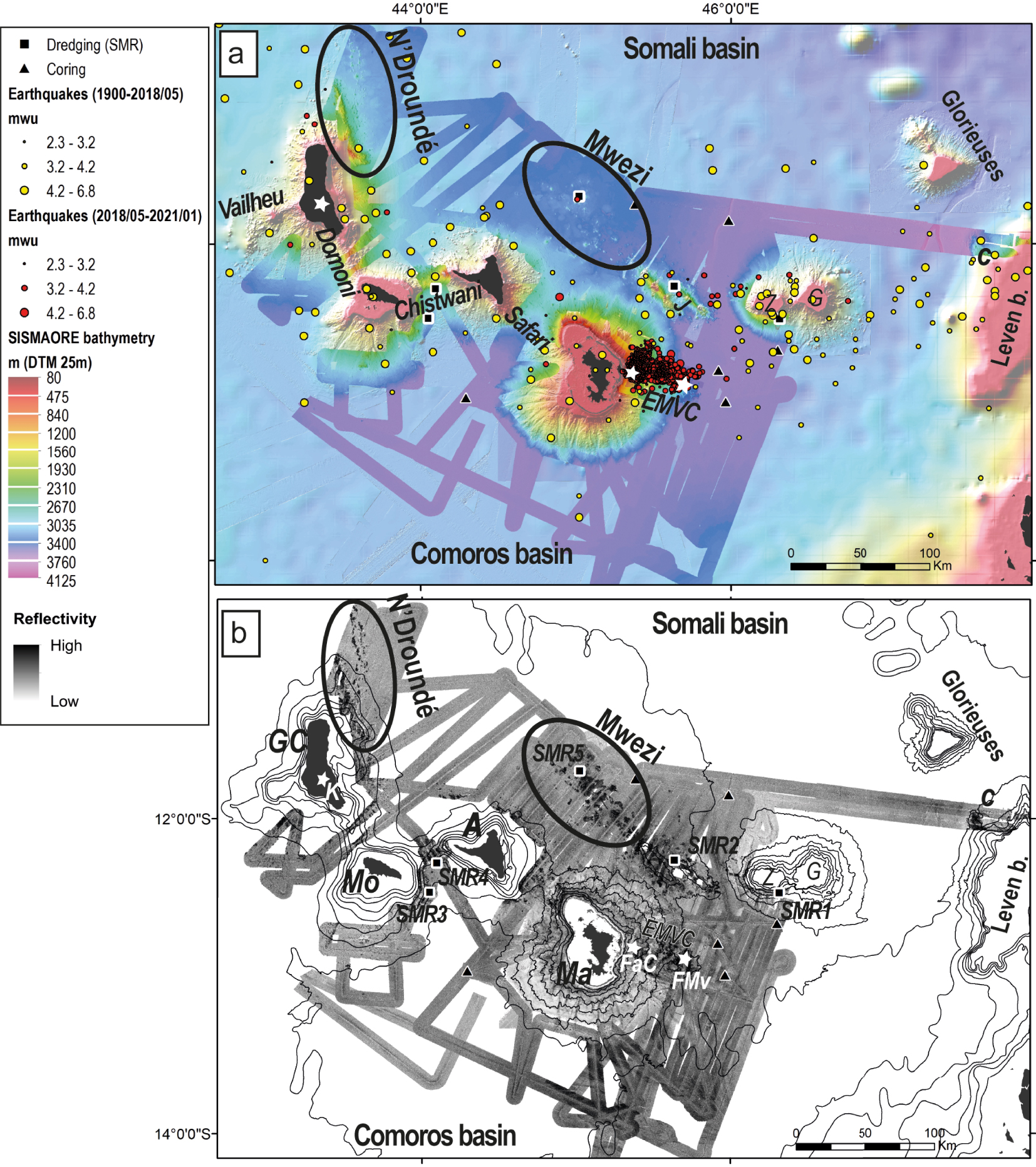
4. Observations and interpretation
On the basis of the new regional MBES bathymetric and backscatter reflectivity data (Figure 3), we prepared a new regional geomorphological map around the Comoros Archipelago (Figure 4). In addition to the islands and seamounts previously mentioned, it portrays two newly mapped large volcanic fields with tectonic structures (the N’Droundé and Mwezi provinces, and the Domoni, Chistwani and Safari submarine volcanic chains that extend between the islands [first described by Tzevahirtzian et al. 2021].
Geomorphological map of the study area showing major structural, volcanic and sedimentary features identified on the SISMAORE bathymetry and backscatter maps (Figure 3) plus features on the insular slopes from earlier work [Feuillet et al. 2021; Paquet et al. 2019; Tzevahirtzian et al. 2021]. The two grey dashed lines mark the boundaries of the Comoros tectono-volcanic corridor described in this paper.
The depth of the abyssal plain ranges between 3000 m and 3800 m (Figure 3a). North of the Comoros Archipelago, the smooth abyssal plain of the Somali basin is interrupted by two large fields of heterogeneous bathymetric features (Figure 3a) and strong reflectivity contrasts (Figure 3b). The first of these, north of Anjouan and Mayotte, is here named the Mwezi Province (“Moon” in Comorian; Figures 4 and 5), and the second, north of Grande-Comore, is here named the N’Droundé Province (from the town of N’Droundé on Grande-Comore; Figures 4 and 6). In the eastern part of the Somali basin are two major valleys trending N–S to NNE–SSW, one on the seabed between the Glorieuses Islands and Leven Bank at 3800 m water depth and one north of Jumelles Seamount and Zélée–Geyser banks at 3600 m (Figures 3a and 4).
(a) Bathymetric map and (b) backscatter map of the Somali basin north of Anjouan and Mayotte, showing seismicity and an incised valley (Va). Outlined regions are shown in (d) and (e), respectively. (c) Interpretive map showing the Mwezi province, Jumelles volcanic chain, Zélée–Geyser Bank and other structural, volcanic, and sedimentary features (for legend see Figure 4). (d) Detail map of seafloor morphology and (e) reflectivity in the central Mwezi Province. Red circle indicates the 24 July 2018 earthquake [3.62 mwu, 15 km depth; Bertil et al. 2021]. C, conical feature; Cc, seamount with summit crater; Cd, seamount with summit dome; D, dome-shaped forced fold; De, depression; F, fault; Lf, lava flow; R, ridge. Supplementary Figure S2 presents oblique views of this area.
(a) Bathymetric, (b) backscatter and (c) interpretive maps of the N’Droundé Province. Three sub-parallel volcanic chains (numbered circles) are marked with thick dashed lines in (c). Note that volcanic chain 1 changes orientation from NNW–SSE to NW–SE as it approaches Grande-Comore (GC), unlike chains 2 and 3. (d) Details of bathymetry and (e) backscatter maps. See Figure 5 for explanation of symbols.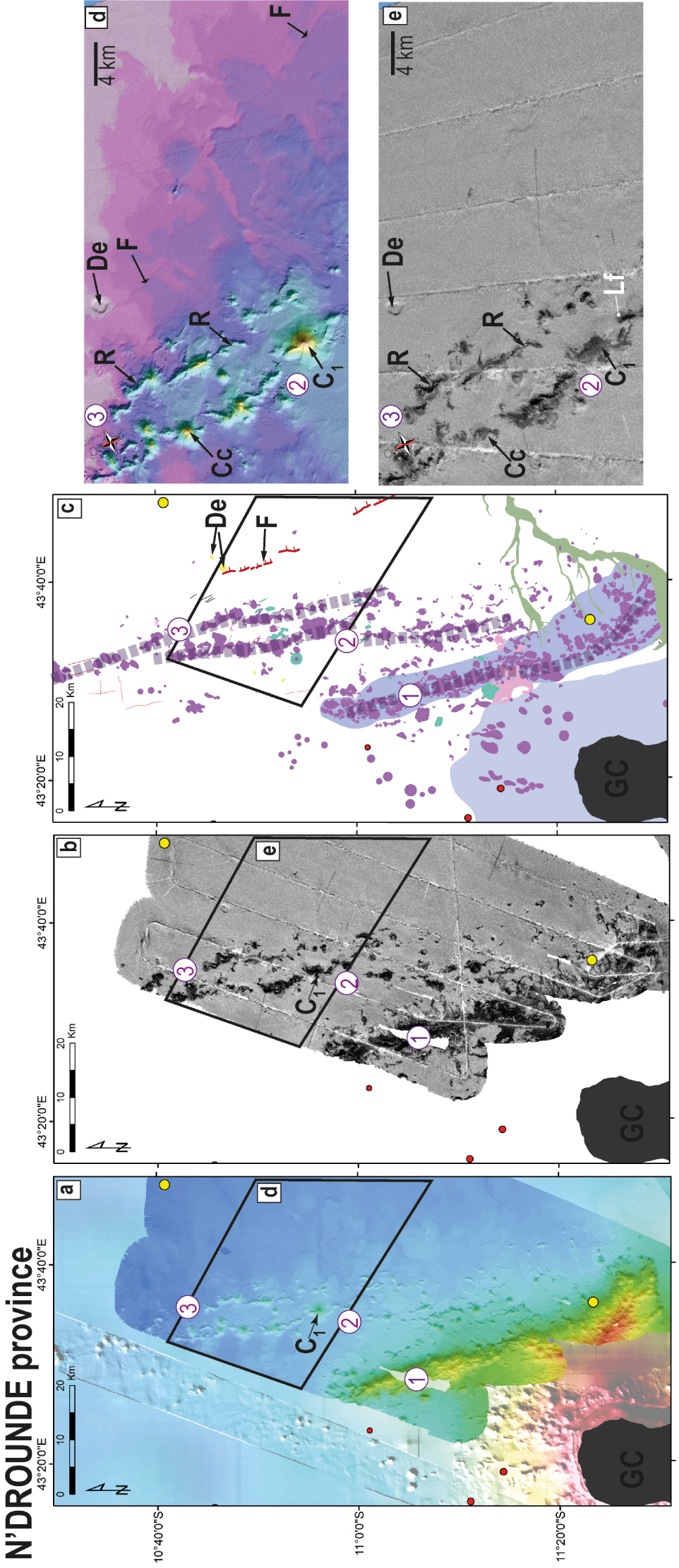
The abyssal plain south of the Archipelago, in the Comoros Basin, has a homogeneous and flat morphology at 3500 m depth (Figure 3a) without strong reflectivity contrasts (Figure 3b). Small reflectivity variations of the flat seabed southeast of Mayotte (Figures 3b and 4) appear to be associated with the distribution of surficial sediment.
East of Mayotte, the EVCM (Figures 3 and 4) comprises elongated ridges, several volcanic cones up to 500–900 m high including the submarine volcano formed during the 2018–2021 eruption, lava flows, and a horseshoe-shaped volcanic complex with current activity [MAYOBS cruises, REVOSIMA newsletter 2021; Feuillet et al. 2021; Rinnert et al. 2019]. Two great dome-shaped forced folds, faults, and possible submarine mass transport deposits described by Paquet et al. [2019] are also imaged (Figure 4).
On the insular slopes, the map depicts the major mass-wasting deposits identified by Tzevahirtzian et al. [2021] and Audru et al. [2006] in new detail. On the abyssal plain, seismic profiles (Figure 7) show that the thickness of the entire sedimentary cover can exceed 2.5 s TWT, or ∼3.1 km based on an average 2500 m⋅s-1 velocity in the sediments [Masquelet et al. 2022].
Selected 48-channel seismic reflection and SBP profiles and their interpretations, showing the subsurface architecture of different volcanic structures visible on the seafloor. Locations shown in Figure 2. (a, b) Orthogonal profiles in the Mwezi Province (MAOR21R002 and MAOR21R075, respectively), (c) NNE–SSW profile in the N’Droundé Province (MAOR21R070) and (d) WNW–ESE profile in the Somali basin north of Zélée–Geyser Bank (MAOR21R001). Gr, graben; V, volcanic edifice; v.e., vertical exaggeration; other abbreviations as in Figure 5.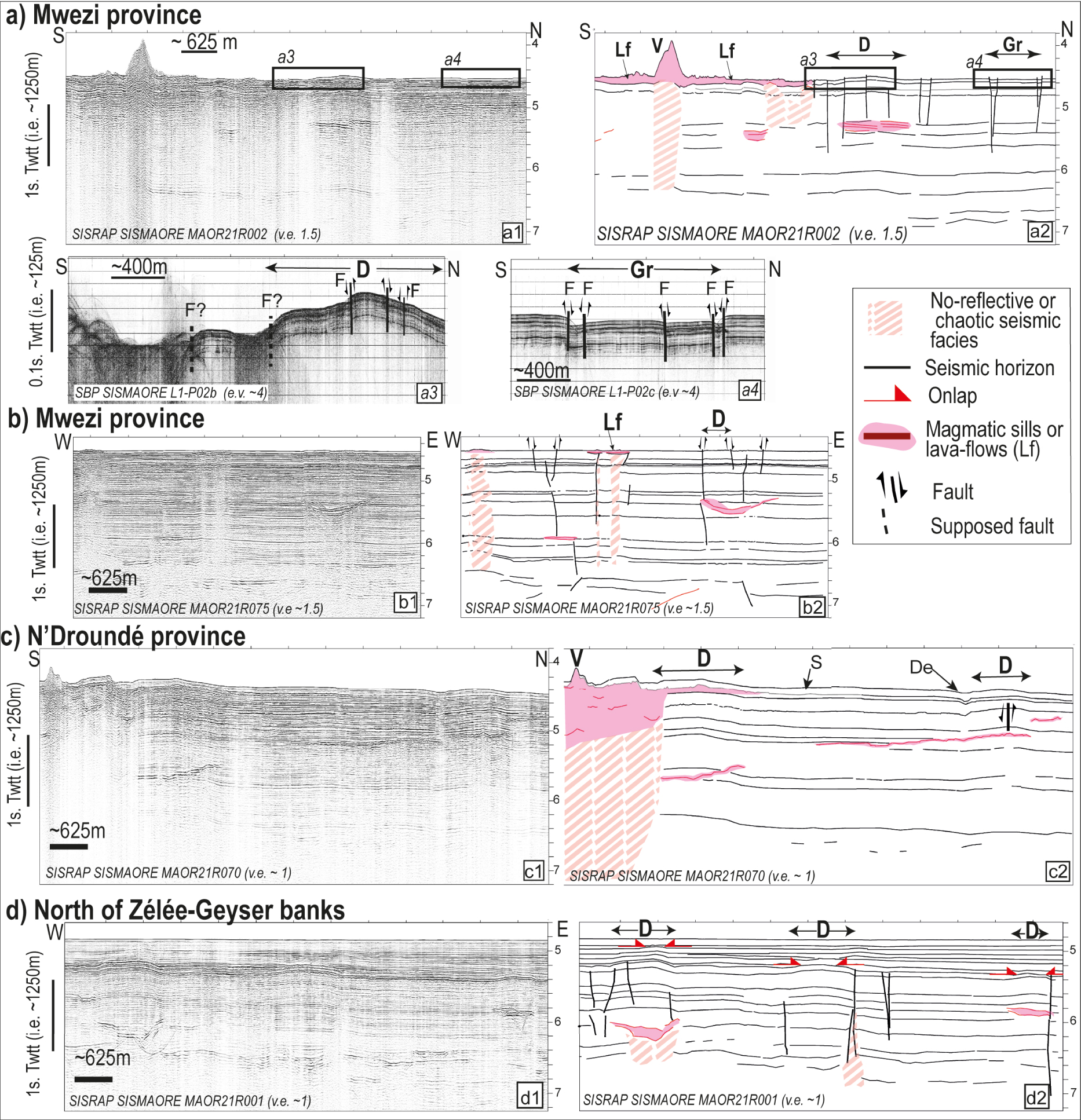
4.1. North of the Comoros Archipelago
4.1.1. The Mwezi tectono-volcanic province
The Mwezi Province covers an area 100 by 60 km (∼6000 km2) in the flat abyssal plain of the Somali basin (∼3400 m depth) and represents a westward extension of the N130°E trending Jumelles volcanic chain (Figure 5). It contains abundant bathymetric features (Figures 5a and d) corresponding to patches with moderate to strong reflectivity (Figures 5b and e). These relief structures include a large number of elongated and steep-sided ridges and conical features (Figure 5d). The ridges are typically 1–4 km in length and reach heights of several hundred metres above the surrounding seafloor. The highest seamount in this area (C1 on Figures 5d and e) stands ∼600 m above a basal depth of 3355 m. The conical features may contain craters (Cc) or domes (Cd) at their summits, and they typically reach diameters of a few kilometres (up to 4 km) and heights up to 600 m. The reflectivity of these features suggests a hard seabed consisting of rocky outcrops or bedrock lightly covered with sediment [Le Gonidec et al. 2003]. Dredge sample SMR5 from one of these seamounts contained popping rocks (Supplementary Figure S1). We interpreted these features as volcanic edifices [Wessel et al. 2010]. They have the same morphology and geophysical characteristics of volcanic edifices to the EMVC, where popping rocks have been sampled from the summit area and fresh lava flows of Fani Maor’e volcano [Berthod et al. 2021a, b; Feuillet et al. 2021], and features of similar bathymetry and reflectivity on the slopes of the Comoro Islands [Audru et al. 2006; Feuillet et al. 2021; Tzevahirtzian et al. 2021].
The backscatter map contains patches of strong reflectivity, some reaching more than 15 km in extent (Lf on Figure 5e), that have little bathymetric relief (Figure 5d). Generally associated with complex roughness and various shapes (commonly lobes), only one patch has a linear shape (Lf1 on Figure 5e, oriented N160°E). We interpret these patches as lava flows, cropping out on the seafloor or lightly covered by very fine sediment. The shapes and sizes of these lava flows suggest low-viscosity lavas like those observed and sampled during the 2018 eruption east of Mayotte [Berthod et al. 2021a, b; Feuillet et al. 2021].
The bathymetric map displays many large and flat circular domes with smooth seabed that reach elevations of 100 m and diameters of several kilometres (D on Figure 5d). They have no reflectivity signature (Figure 5e). Seismic profiles across these domes show an uplifted and faulted sedimentary cover overlying an abrupt, high-amplitude terminating reflector, often displaying a saucer-shaped profile (Figure 7a,b). These deep reflectors are consistent with shallow magmatic intrusions (sills or laccoliths), which would induce domal uplift and faulting of the overlying sedimentary cover [Kumar et al. 2022; Medialdea et al. 2017; Montanari et al. 2017; Omosanya et al. 2017, and references therein]. We interpret these domes as forced folds by analogy to the description of Paquet et al. [2019] and other sources [Montanari et al. 2017, and references therein]. The analogue modelling of Montanari et al. [2017] shows that the growth of dome-shaped forced folds produces tensional and compressional deformation (normal and reverse faults) in the sedimentary cover. Some of the dome-shaped forced folds in the Mwezi province are accompanied by faults with sub-vertical offsets reaching 10 m (Figure 7a2–a4, b). The disruption of seismic signals under and over the sills may result from the presence of overlying lava flows (acoustic masking) or fluid migration pathways (chimneys) [Masquelet et al. 2022, and references therein].
Most of the volcanic structures, ridges and seamounts are distributed along ∼N130°E trend (Figure 5c). In addition, steep escarpments identified on the seafloor are mainly oriented ∼N130°E in the centre of the Mwezi province and mainly oriented ∼N–S on the northern edge. They are as long as 10 km and have vertical offsets of up to 10 m (see F1, F2, F3 on Figures 5d and 7a3). Some of these escarpments consist of discontinuous, slightly shifted segments (Supplementary Figure S2). Some connect seamounts or domes, and some cut across domes producing vertical offsets of 10–20 m (see F1 cutting domes D3 and D4 on Figure 5d; Supplementary Figure S2). We interpret these escarpments as faults with sub-vertical components.
4.1.2. The N’Droundé tectono-volcanic province
The N’Droundé Province covers an area 40 by 100 km (∼4000 km2) at the western end of the Comoros Archipelago, north of Grande-Comore, and consists of three subparallel NNW–SSE striking submarine topographic features (Figure 6). The southernmost of these is 60 km long and ∼15 km wide, with a summit reaching a depth of 1230 m above a base at 3000 m (feature 1 in Figure 6). Near its southeastern tip, its orientation changes smoothly from N160°E to N130°E. The other two are parallel lines of relief features, oriented N160°E, about 130 km long and averaging 5 km in width at 3100 to 3400 m depth (features 2 and 3 in Figure 6). They have a wide variety of shapes, including narrow ridges and conical edifices some of which have craters or breached craters at their summits (Figure 6d). These are between 1 and 5 km in diameter and a few kilometres long and reach heights of several hundred metres above the surrounding seafloor. The highest seamount rises 735 m to a depth of 2472 m (C1 on Figure 6a). We interpret these seamounts as volcanic edifices. Some dome-shaped forced folds appear in seismic profiles in the N’Droundé Province (D on Figure 7c), but few affect the seafloor and have elevations less than 100 m. Most of them are covered by a thin layer of a chaotic or non-reflective unit (max. 0.1 s TWT; V and S on Figure 7c). Significant deposition of sediments from the Grande-Comore may result in a smoother bathymetry here than in the sediment-starved Mwezi Province. Alternatively, the N’Droundé seamounts are older than those in the Mwezi Province and have a thicker sedimentary cover. Along with the seamounts are N160°E-trending sub-vertical escarpments a few metres high, forming relays that cut the seafloor (F on Figure 6d).
4.2. Other evidence of recent volcanism in the Comoros Archipelago
4.2.1. Submarine volcanic chains
The Safari volcanic chain between the islands of Anjouan and Mayotte has several volcanic edifices consisting of conical seamounts, ridges, eruptive fissures and lava flows (Figures 3, 4 and 8). The conical seamounts are aligned in a 130°E trend and reach heights of up to 400 m and diameters of 1 to 1.5 km (Figure 8, Supplementary Figure S3). Large high-reflectivity patches near them are interpreted as lava flows, and low-reflectivity patches are interpreted as lava flows covered by a thin layer of sediment (Figure 8b,e). The ridges, which trend NW–SE, are up to several kilometres long, hundreds of metres wide, and 200 m high (R on Figure 8d) and may contain depressions on their summits as deep as about 20 m (Ef1 on Figure 8d–f). One of these ridges transitions into a crack 2 km long with walls up to 20 m high and a high-reflectivity signature (Ef2 on Figure 8e,f). Similar features on Axial Seamount (Juan de Fuca Ridge) have been interpreted as eruptive fissures [Chadwick et al. 2019; Clague et al. 2011].
(a) Morphology of the Safari volcanic chain between Anjouan and Mayotte islands from SISMAORE MBES bathymetry data (greyscale) and previous surveys (colour, from Tzevahirtzian et al., 2021). (b) Backscatter map. (c) Interpretive map showing conical volcanic edifices (C), ridges (R), lava flows (Lf) and eruptive fissures (Ef). (d) Detail of (a) and (e) detail of (b). (f) Cross-sections across the ridges (R) and crack fissures (Ef2) observed on the seafloor. Supplementary Figure S3 presents oblique views of this area.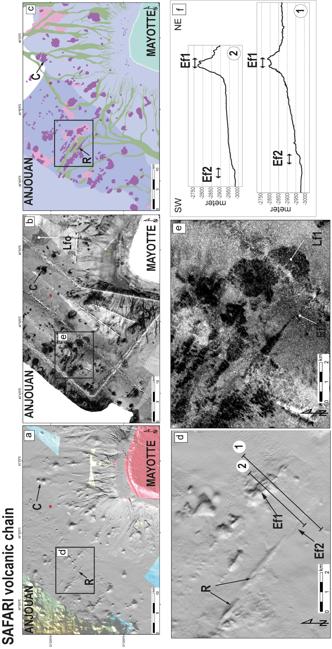
Other major submarine volcanic chains, such as the Domoni and Chistwani chains (Figures 4 and 9, Supplementary Figure S4) contain volcanic edifices including conical seamounts, ridges and lava flows. The dredged rocks from the SE flank of the Chistwani chain (SMR4) are basaltic [Thinon et al. 2020b]. This widespread array of volcanic structures is evidence of several phases of volcanism that have formed submarine volcanic chains throughout the Comoros Archipelago, both between the islands (Domoni, Chistwani, and Safari chains) and beyond them (Vailheu chain and the EMVC).
(a) Oblique view showing the morphology of the Chistwani volcanic chain between Mohéli and Anjouan. Oriented N 55°E, the chain is narrow (∼20 km wide), asymmetric (steeper SE flank), and rises ∼500 m (up to 2830 m depth) above the surrounding abyssal plain (3400 m depth). (b) Interpretive map showing volcanic edifices (purple) and lava flows (pink) at the top of the volcanic chain. Black dashed lines indicate en echelon lineaments that may represent a dextral motion.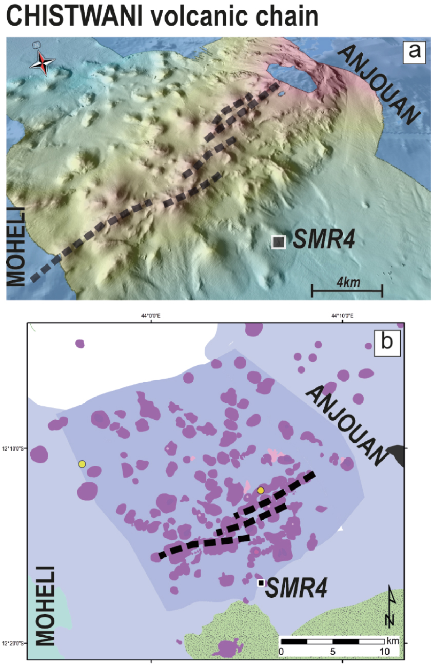
4.2.2. Other volcanic evidence
Grande-Comore, Mohéli, and Anjouan have rugged insular slopes covered with mass-wasting deposits (detrital cones) and outcropping blocks [Tzevahirtzian et al. 2021; Figure 4]. In the volcanoclastic deposits on the south slope of Grande-Comore, some small conical edifices and various patches with high reflectivity have been identified (Figure 10a).
Bathymetric (left) and backscatter (right) maps of (a) the southern slope of Grande-Comore Island and (b) the lower western slope of Cordelière Bank. Also shown in (b) is detailed bathymetry of a conical volcanic edifice (C) with a potential lava flow (Lf). Lf0, lava flow with relatively low reflectivity due to sediment cover; other symbols as in Figure 5.
Unlike the other Comoro Islands, the slopes of Mayotte (except the eastern slope) have a relatively smooth bathymetry and a mottled appearance [Audru et al. 2006; Tzevahirtzian et al. 2021; Figures 4 and 11a]. Major mass-wasting deposits are absent, and only a superficial submarine landslide deposit no higher than 20 m is apparent at the foot of the western flank (Figure 11a,b). In this area, the strongest reflectivity features mainly correspond to canyons and a few small isolated seamounts not covered by sediments (Figure 11c,d). Seismic profiles indicate that the smooth and mottled-bathymetry features correspond to sediment deposits (Figure 11e,f). The sedimentary unit covering the acoustic basement off Mayotte can reach thicknesses of ∼0.5 s TWT (roughly 500 m in using 2000 m⋅s-1 velocity) and often covers volcanic edifices. On the western slope of Mayotte, three nearly conical seamounts exhibit a N160°E alignment (Figure 11a,c,d). By creating a barrier for sediment transport on the western slope, these seamounts potentially control the shape of a submarine canyon. A larger number of conical seamounts on the northern slope of Mayotte lie in a N130°E trending corridor between the Safari volcanic chain and Fani Maor’e volcano, in agreement with previous observations [Audru et al. 2006; Famin et al. 2020; Tzevahirtzian et al. 2021].
(a) Shaded bathymetric map of the western slope of Mayotte with location of MARO21R105 seismic line (black line). Small cluster of volcanic edifices (C) forms a NW–SE trend and outlines the western rim of a major canyon. (b) Detail of (a) showing the mass-wasting deposit—at the foot of the slope (3544–3521 m depth). (c) Detail of (a) showing the N160°E alignment of volcanic cluster. (d) Reflectivity map of the area in (c). (e) Interpreted and (f) migrated 48-channel seismic profile MARO21R105, oriented EW (location in (a)).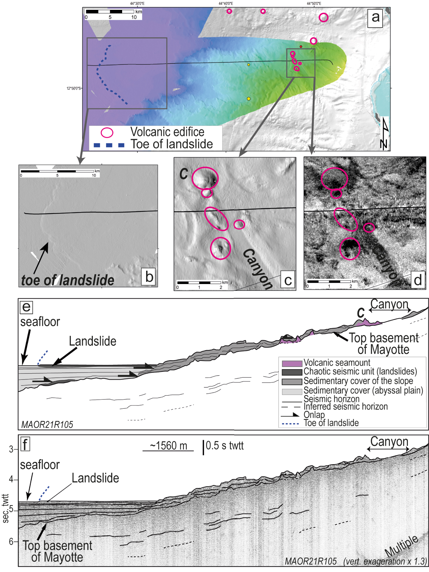
On the flanks of Zélée Bank, dredging sample SMR1 consists of volcanic rocks [Figure 3; Thinon et al. 2020b]. In the abyssal plain north of Zélée–Geyser banks, 0.2 s TWT high dome-shaped forced folds are observed in the seismic profiles (i.e. ∼200 m with 2000 m⋅s-1 velocity; Figure 7d). However, they have no surface expression owing to the thick sediment cover (0.15 to 0.4 s TWT), which is thicker than the cover on the dome-shaped forced folds in the Mwezi (quasi-nonexistent) and N’Droundé Provinces (max. 0.1 s TWT). Dome-shaped forced folds and sills exist also east of Mayotte near Fani Maor’e volcano [Figure 4; Masquelet et al. 2022; Paquet et al. 2019; Rolandone et al. 2022].
To the east of the Comoros Archipelago, we identified evidence of volcanism near the Madagascar margin. A small conical seamount and an 85 km2 high-reflectivity patch with lobe-shaped and roughened facies were identified at the foot of the western slope of Cordelière Bank (Figure 10b). Their morphology and reflectivity suggest that they are recent volcanic structures, in agreement with the evidence of volcanism suggested by dredge sampling in this area [Daniel et al. 1972].
4.3. Distribution of volcanic and tectonic structures in the Archipelago
The great N’Droundé and Mwezi volcanic provinces in the Somali abyssal plain, together with the four Comoro Islands and the major seafloor volcanic chains around them, constitute a volcanic corridor 600 km long and 200 km wide (Figure 4). Mapping based on the SISMAORE cruise data shows on the seafloor the presence of up to 2200 recent volcanic edifices and lava flows, covering an area of ∼5300 km2 (∼2500 km2 of cones and ridges and ∼2800 km2 of lava flows), plus dome-shaped forced folds on the seafloor with an area larger than 972 km2 throughout the Comoros Archipelago.
At the western end of the Comoros Archipelago, volcanic features are distributed mainly along a N160°E direction (N’Droundé, Grande-Comore, Domoni). To the east of Mohéli and Anjouan, the volcanism is distributed mainly along a N130°E direction (Mwezi, Jumelles, Safari, EMVC). The topography of the Mwezi Province and the two northernmost volcanic chains in the N’Droundé Province is less significant than that of the highest volcanic chains (Jumelles, Domoni, Chistwani, EMVC). The Mwezi and N’Droundé volcanic fields thus may be nascent volcanic chains, younger than the major and polyphase chains elsewhere in the corridor.
The faults identified in the abyssal plain of the Somali basin and east of Mayotte display two main orientations. Faults trending N130°E are mainly in the Mwezi province, east of Mayotte, and in the Safari volcanic chain, and faults trending N160°E are mainly in the N’Droundé province, in the Domoni volcanic chain and on the western upper slope of Mayotte (Figure 4). North–south to NNE–SSW trending faults exist in the northern part of the Mwezi Province. These sets of faults and volcanic structures, both too recent to be covered by sediments, appear to be coeval as they crosscut each other in many cases. Some of the faults cut the surface of the dome-shaped forced folds or connect two major structures (e.g., fault Lf1 in Figure 5e, Supplementary Figure S2). They can form graben systems (e.g., Figures 5d, 7a2 and 7a4) or lines of offset segments (e.g., Figure 6c,d). Most of the faults show sub-vertical offsets reaching 20 m, often with a normal component (Figure 7, Supplementary Figure S2). Strike-slip motion could exist, but is not easy to identify in the seismic profiles.
The eastern flank of the Chistwani volcanic chain contains three lines of volcanic edifices and ridges with ENE–WSW (N60°E to N90°E) orientations (Figure 9). Some east-facing scarps are present. These lineaments are arranged en echelon, as if they reflected the influence of a dextral motion.
5. Discussion
Our interpretations of bathymetry and backscatter maps and seismic profiles revealed a widespread regional distribution of recent volcanic and tectonic deformation that allows us to propose a geodynamic context for the Comoros Archipelago and address questions about the role of the structural inheritance (Figure 12).
(a) Regional geological context of the Comoros Archipelago, including the distribution of recent volcanism and tectonics identified from this study and the proposed diffuse and nascent Somalia–Lwandle plate boundary. See Figure 1 for legend. (b) Geodynamic interpretation of recent tectonic and volcanic structures and the fossil Mesozoic crustal fabric of the study area. Shown are major faults and lineaments from this study as well as tensile fractures from this study (Tf4) and from Famin et al. [2020] and Feuillet et al. [2021] (Tf1, Tf2, Tf3). Locations, focal mechanisms and dates of earthquakes (up to Mw 5) are from Bertil et al. [2021] and references therein and pre-existing crustal fabric, derived from magnetic data, is from Davis et al. [2016]. (c) Regional tectonic setting between the EARS and Madagascar. K, Kerimbas basin; A, Ambilobe basin. Grey dashed lines mark the diffuse, immature Somalia–Lwandle plate boundary.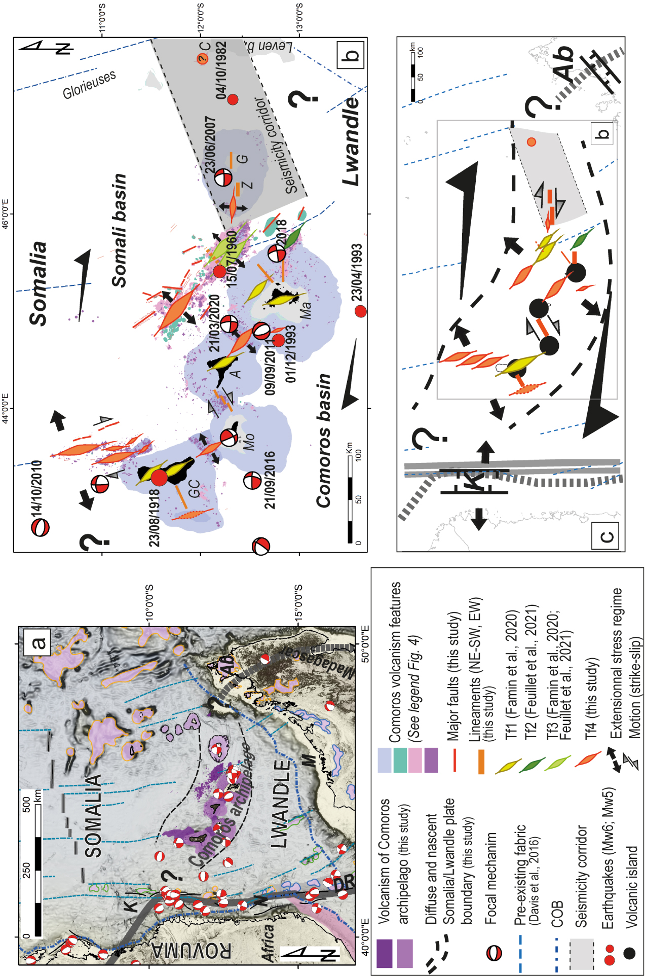
5.1. Tectono-volcanism events in the Comoros Archipelago
The volcanic and tectonic structures in the abyssal plain rest on a sedimentary sequence ∼3 km thick (Figures 7 and 11), in agreement with previous authors [Coffin et al. 1986; Leroux et al. 2020; Masquelet et al. 2022].
In the sediment-starved Mwezi Province (Figures 4 and 5), the near-absence of sediments on lava flows, volcanic edifices, forced folds, and faults suggests that volcano-tectonic activity, though undated, is very recent. The high-reflectivity of these seafloor features is similar to that of the lava flows from the 2018–2021 Fani Maor’e volcano eruption [Deplus et al. 2019; Feuillet et al. 2021]. Moreover, the presence of popping rocks in dredge sample SMR5, in the Mwezi province (Supplementary Figure S1), implies that the residence time of these seafloor basalts has been too short to permit complete degassing. The evidence is consistent with very young volcanic activity in the Mwezi Province. We propose that fresh outcrops and seafloor features represent similarly recent volcanic and tectonic activity throughout the Comoros Archipelago, including in the N’Droundé Province, on the slope of Grand-Comore, in the Safari volcanic chain, at the foot of the Jumelles volcanic chain and on the Cordelière Bank (as shown in purple in Figures 4 and 12). However, no current volcanic eruptions or fluid activity were apparent in the water column acoustic data from the SISMAORE cruise except east of Mayotte [REVOSIMA newsletter 2021; Thinon et al. 2020a].
There are more lava flows and dome-shaped forced folds visible on the seafloor in the Mwezi Province than in the N’Droundé Province. This difference could be due to magmatic events of differing intensities or ages; however, in the N’Droundé Province, many dome-shaped forced folds and lava flows are covered by as much as 100 m (0.1 s TWT in using 2000 m⋅s-1 velocity) of sedimentary deposits or other volcanic products (Figure 7c). This province receives an abundant sediment supply from wave erosion and coastal hydrodynamic processes at Grande-Comore, whereas the Mwezi Province is more distant from sediment sources.
North of the Zélée–Geyser banks, a significant sedimentary cover onlaps the dome-shaped forced folds (0.15–0.4 s TWT or 100–400 m in using 2000 m⋅s-1 velocity, Figure 7d), hides the surface deformation induced by magmatic intrusions. Even if sedimentation rates differ between the two areas, these forced folds appear to be older than those in the Mwezi province, which disrupt the seafloor. This difference is consistent with the long-term magmatic history of the north Mozambique Channel [Michon 2016], and with the emplacement of the Zélée–Geyser banks, which are older than the Comoro Islands to the west [Leroux et al. 2020]. We suggest that the Mwezi and N’Droundé provinces consist mainly of monogenetic volcanic cones and lava flows whereas submarine volcanic chains (Jumelles, Chistwani and Domoni) and Zelée–Geyser banks are products of a complex evolution and are akin to multiphase constructional structures such as the EVCM [Feuillet et al. 2021; Masquelet et al. 2022] or islands such as Mayotte [e.g., Nehlig et al. 2013]. Based on our comparisons of topographic features and backscatter signatures, we propose that most of the volcanic and tectonic structures in the Mwezi and N’Droundé provinces are younger than those of volcanic chains and Zelée–Geyser banks.
The evidence of widespread recent volcanic activity on submarine volcanic chains and islands (purple shades on Figure 4) suggests the occurrence of multiple volcanic events throughout the Comoros Archipelago. The volcanic structures identified on Cordelière Bank (conical edifices and lava flows; Figure 10b) appear to be the products of recent eruptive events from their morphology and strong reflectivity, more recent than those of the Glorieuses Islands [Late Cretaceous according to Leroux et al. 2020]. A pattern of multiple phases separated by periods of quiescence would be similar to that of Mayotte, where volcanic activity occurred between 10.6 and 1.9 Ma and then resumed during the Pleistocene [Bachèlery et al. 2016a; Michon 2016; Pelleter et al. 2014].
These faults and volcanic structures appear to be coeval as they crosscut each other in many instances yet are both too recent to be covered by sediments. Some of the faults form and grow in response to local stress fields caused by magmatic intrusions and eruptions [see Sections 4.1 and 4.2; Figure 7; Montanari et al. 2017]. However, the major fault trends (N130°E and N160°E to N–S) and the alignment of seamounts in the Mwezi and the N’Droundé provinces are consistent with the regional stress field. During the ongoing eruption off Mayotte, magma appears to ascend through NW–SE trending lithospheric structure, consistent with the regional stress field [Berthod et al. 2021b; Feuillet et al. 2021; Lemoine et al. 2020].
5.2. Spatial distribution of deformation and current kinematic context
From the distribution of recent volcanic and tectonic structures, we identified geologically recent diking events throughout the Comoros Archipelago (Figure 12a), including the Mwezi Province (N130°E), N’Droundé Province (N160°E), Safari volcanic chain (N130°E) and Domoni volcanic chain (N160°E). Figure 12a shows groups of tensile fractures (Tf1–Tf4) corresponding to the main tectono-volcanic provinces and volcanic chains that were identified from the SISMAORE data and previous studies [Famin et al. 2020; Feuillet et al. 2021], as well as major faults and lineaments. These observations suggest the presence of major en echelon tensile fractures and secondary Riedel shears (Figure 12) in the Comoro Islands, Jumelles volcanic chain, Zélée–Geyser banks, and north of Anjouan. Feuillet et al. [2021] also interpreted the EVCM as a tensile fracture. Features with roughly orthogonal (ENE–WSW) azimuths in the Comoros Archipelago, such as those in the Chistwani volcanic chain (Figure 9), may have originated in diking events with right-lateral strike-slip motions.
The shift in the orientation of principal tensile fractures from N160°E in the west to N130°E to E–W in the east suggests a segmentation of the Archipelago (Figure 12). At the western end, the azimuths of the major volcanic structures tend to be parallel to the offshore branches of the EARS, such as the N–S trending Kerimbas graben along the Tanzanian/Mozambican coast [Franke et al. 2015; McGregor 2015; Mougenot et al. 1986; Figures 1 and 12]. Taken as a whole, seismicity in the Comoros Archipelago outlines a rather narrow deformation zone that changes direction around Mayotte (Figure 12b). On the east, recent seismicity is distributed within an ENE–WSW (N80°E) corridor from west of Jumelles to Madagascar [especially from 2018; Bertil et al. 2021], and on the west it is concentrated in an NW–SE direction to the west of Mayotte. The N80°E trend of the eastern segment is parallel to the ENE–WSW Ambilobe sedimentary basin of northern Madagascar, of Cenozoic age [Piqué et al. 1999; Roig et al. 2012]. The observed tectono-volcanic structures on Zélée–Geyser banks are oriented roughly E–W. The same change in the orientation of tectono-volcanic structures corresponds to a change in the pattern of earthquakes, which are relatively diffuse to the west, where the structures trend from NNW–SSE to NW–SE, and less diffuse to the east, where they form a corridor trending N80°E and the tectono-volcanic structures trend approximately E–W. The few available focal mechanisms support a transtensional stress regime (Figure 12b). The current stress regime is consistent with a NE–SW direction of least stress (𝜎3) and a NW–SE direction of greatest stress (𝜎1), which implies an overall right-lateral deformation pattern that produces en echelon tensile fractures parallel to 𝜎1 and perpendicular to 𝜎3 in alignment with the principal volcanic chains. The transtensional stress field promotes dikes, as attested by the recent Mayotte eruptions.
The new data presented in this paper show that the recent volcanic and tectonic structures on the seafloor form a corridor some 200 km wide and 600 km long that includes the southern abyssal plain of the Somali Basin and the Comoro Islands from west of Grande-Comore to Madagascar (Figures 4 and 12). Volcanism and faulting are absent on the seafloor in the Comoros basin south of the Comoro Islands. Note that this tectono-volcanic corridor does not closely match the “broad zone of deformation” proposed by Stamps et al. [2021] from GNSS modelling, which extends 1000 km from the Comoros Archipelago, including the northern half of the Lwandle plate, and the Comoros basin. Indeed, the regional GNSS network is not optimally configured [Bousquet et al. 2020] to clearly constrain the regional kinematics. The tectono-volcanic corridor shown in Figure 12 more closely corresponds to the Somalia–Lwandle plate boundary previously proposed by previous studies [e.g., Calais et al. 2006; Famin et al. 2020; Stamps et al. 2021].
In this tectono-volcanic corridor, no major fault systems affect the seafloor like those observed, for example, along the NE–SW Atlantic plate boundary in the Azores region [Sanchez et al. 2019]. The faults in the corridor are small (less than 10 km long with apparent vertical throws no greater than 20 m) and discontinuous (Figures 4 and 12). The absence of large (M6+) earthquakes and the fact that the largest reported events are associated with volcanic events, such as the 1918 eruptions of Karthala in Grande-Comore [Bachèlery et al. 1995, 2016b] and the 2018–2021 offshore Mayotte eruption, are further evidence of the lack of major faults in the Comoros Archipelago. If a dextral transform boundary between the Somalia and Lwandle plates is present in the Comoros Archipelago, the low intensity of deformations suggests that it is very immature or incipient.
5.3. Relationships between plate boundary forces, the role of inheritance and magmatism
The study area is the locus of interactions between deformation at plate boundaries and intense magmatism.
We propose that the young tectonic and volcanic structures identified in this study mark the location of a diffuse, immature Somalia–Lwandle plate boundary between the EARS and Madagascar (dashed lines in Figures 4 and 12). A recent to current regional regime of dextral transtension explains well the location and orientation of volcanic and tectonic structures like the Mwezi province and the part of the EMVC associated with the active Fani Maor’e volcano. Particularly to the west of Mayotte, these features are well aligned with the pre-existing crustal fabric of the Somalia basin, interpreted from magnetic and gravity data as Mesozoic transform fault zones by Davis et al. [2016] and Phethean et al. [2016] (Figure 12a). We propose that these pre-existing oceanic fracture zones play a role in the distribution of the N–S to N160°E younger seafloor features by acting as weak zones, prone to reactivation in the current regional stress field (dextral shear with NE–SW tension axis or transtension), as Sauter et al. [2018] have established in the northwestern Somali basin. The volcanic complexes of the Comoro Islands appear to be located at intersections between tensile fractures guided by pre-existing fracture zones and NE–SW trending volcanic chains lying nearly parallel to the lithospheric fabric evident from magnetic anomalies in the southern Somali basin. These observations are consistent with a reactivated fossil fabric that guides magma ascent and controls the sites of volcanism on the seafloor.
However, the relationship between young seafloor features and earlier tectonic fabric is less clear east of longitude 44.5°E, from Anjouan to Madagascar. The N160°E trend of free-air gravity anomalies is subdued in this region, and the N130°E and E–W orientations of tectono-volcanic features in the Mwezi Province, the Jumelles and Safari volcanic chains, the EVCM, and the Zélée–Geyser banks are clearly oblique to the N–S to N160°E orientation of the fossil fabric. It may be that the N130°E trending structures have formed in response to the current geodynamic context of an immature plate boundary, independent of the inherited lithospheric structure. However, studies of other regions with heterogeneous lithosphere and active regional and local geodynamic contexts, especially in the Wharton basin in the Indian Ocean [Delescluse and Chamot-Rooke 2007; Deplus et al. 1998; Hananto et al. 2018; Stevens et al. 2020, and references therein] have reported that the orientations of new and reactivated faults, and of deep and surface structures, may be different. They also suggest that shallow deformations can be influenced by both pre-existing structures and local or regional stress fields. A strong influence of a mantle melting anomaly or mantle convection cannot be excluded [Tsekhmistrenko et al. 2021]. Thus, clarifying the relationship between recent seafloor deformations, fossil fabrics of the oceanic crust, and the presence or absence of oceanic crust under the Comoros Archipelago, requires further work that is being conducted in the framework of the ANR COYOTES project [e.g., Boymond et al. 2022; Masquelet et al. 2022; Rolandone et al. 2022; Thinon et al. 2020b].
6. Conclusions
Our SISMAORE cruise has shed light on a hitherto poorly known area around the volcanic Comoros Archipelago. Bathymetric and backscatter data, seismic profiles and dredge samples have revealed up to 2200 volcanic edifices and lava flows on the seafloor of the Comoros Archipelago, in the abyssal plain, on the submarine volcanic chains and on the slopes of the Comoro Islands. Other newly identified features include dome-shaped forced folds linked to sill intrusions in the thick sedimentary cover of the abyssal plain. The majority of these structures are located two great volcanic and tectonic fields in the abyssal plain: the N’Droundé Province, north of Grande-Comore and the Mwezi Province, north of Anjouan and Mayotte. Dredge samples of fresh rich-gas basaltic rocks in the Mwezi Province suggest that volcanic activity, although still undated, is very recent. The Comoro Islands, the major submarine volcanic chains and the N’Droundé and Mwezi provinces are interpreted as tensile fractures associated with diking events, consistent with the current regional tectonic setting of right-lateral transtension. Although the distribution of present-day to Pleistocene tectonic and volcanic structures in the western part of the Comoros Archipelago appears fairly congruent with the pre-existing crustal fabric, in the eastern part the role of inheritance is less clear. The distribution of recent deformation appears mainly compatible with the current kinematic context, with possible influence from the pre-existing crustal fabric and heterogeneities in the lithosphere. A strong influence of a mantle melting anomaly or mantle convection cannot be excluded.
The recent volcanic and tectonic structures, as well as the regional seismicity, are distributed within a corridor at least 200 km wide, including the Comoro Islands and the abyssal plain to their north, that extends 600 km between the EARS and Madagascar. The distribution of volcanic and tectonic structures, and by inference the orientation of major tensile fractures, shifts in segments from a roughly N–S orientation in the west, to N160°E, to N130°E to E–W in the east. The Comoro Islands tend to lie at the junctions between tensile fractures (N160°E and N130°E) and ENE–WSW lineaments. This regional distribution of the recent structures is consistent with seismicity patterns in the Comoros Archipelago.
We interpret the Comoros tectono-volcanic corridor as a marker of the Somalia–Lwandle plate boundary. Although the corridor is prone to episodes of intense volcanism, the low intensity and style of deformation tends to confirm the very immature state of this dextral strike-slip plate boundary.
Conflicts of interest
Authors have no conflict of interest to declare.
Acknowledgments
The SISMAORE cruise was mainly funded by the Flotte Océanographique Française and the French geological survey (BRGM). We thank Captains P. Moimeaux and G. Ferrand of R/V Pourquoi Pas? and its crews and technicians especially and GENAVIR team for the bathymetry processing and the seismic deployment. Thanks to the BRGM regional department of Mayotte, Ifremer, REVOSIMA and the Délégation interministérielle aux risques majeurs Outre-mer for their assistance during the COVID health crisis. We also thank the Rectorate of Mayotte and two of its teachers (J. Jacquot, P. Deparis) for their participation, the Mission Sismaoré blog (https://sismaore.ac-mayotte.fr/) and the primary and high school students for the richness of exchanges. Thanks to the laboratory of BRGM for gas analysis and to D. Bertil for discussions on regional seismicity.
This paper is a contribution of the COYOTES (COmores & maYotte: vOlcanisme, TEctonique et Sismicité) and SISMAORE teams. This paper benefited from the previous works of the REVOSIMA community. The reviewers are greatly acknowledged for their comments and recommendations, which helped us to significantly improve an early draft of the manuscript. We also thank M. A. Alden for language editing. The processing and the detailed analysis of these geophysical and geological data are carried out mainly in the framework of the COYOTES project (ANR-19-CE31-0018; https://anr.fr/Projet-ANR-19-CE31-0018) funded by the French Agence Nationale de Recherche and the BRGM.