


 CC-BY 4.0
1. Introduction
“It is not a sin to take excessive safety precautions; it should be the rule. After all, who blamed Che-Huang-ti, Chinese emperor of the 3rd century B.C., for building the Great Wall (probably one of the greatest works of man to this day) even if it was never needed?” [de Marsily 1982]. It is with these words that Ghislain de Marsily ended his foreword to the proceeding volume of the 26th Congress of IAMG (International Association for Mathematical Geosciences) held within the International Geological Congress (IGC), Paris in 1980. The small but distinguished IAMG had introduced mathematical and statistical prediction methods in order to estimate mineral resources. Here, their focus was on prediction of potential risks associated with nuclear power and its waste management.
A few lines earlier, he stated: “However, they (the volume’s papers) also make it clear that geologists are a long way from the ultimate goal which is meaningful risk analysis. Until this goal is reached, it is the responsibility of the world geological community (i.e. each of us) to ensure that no decisions are made, which take the stability of the present world for granted, ignoring basic geodynamic processes, which may increase drastically the risk associated with the decision. Whereas individuals are free to accept various risks, society is not, and the risk to which our own species may be exposed in the future should be reduced to a minimum, which is the law of nature in any ecosystem.”
The following paper aims at demonstrating how Germany, i.e. parliament and government, society and scientists, is honestly struggling to live up to this principle of calculating, assessing and minimizing all risks associated with the underground storage of high-level radioactive waste. This is currently necessary after all previous plans to select an appropriate high-level waste (HLW) repository in Germany had failed.
After WWII, many nations have profited from civil use of nuclear power. Also, Germany became enthusiastic about an apparently endless energy source which seemingly causes no environmental damages compared to the consumption of fossil fuels. Interestingly, in the early 60s when West Germany enhanced the mining of vast amounts of hard coal, some energy supply companies were skeptical to bear the economic risk of nuclear energy production. This attitude changed soon, when the so-called Energy-Gap was envisioned. Both Germanies started to rely on nuclear energy production [EndKom 2016]. The first atomic power plant in West Germany was put into operation in Bavaria in 1966, the former German Democratic Republic (East Germany) followed with the nuclear power plant Bruno-Leuschner in 1974 in Lubmin-Greifswald. Its latest block operated only a month, in November 1989—the year of the “Wende”—before the plant was finally shut down. The former power plant’s site is now used as one of the sixteen interim storage facilities in Germany. It also provides technical knowledge and services in dismantling and disposal of nuclear energy facilities [EWN 2022].
Nuclear power plants produce the most intensively radiating waste. Whereas HLW [IAEA 2009] only encompasses ten percent of the total volume of radioactive waste, it covers more than 99% of the total radioactivity. By the end of 2022, which is the date when all German nuclear power plants were planned to be shut down, approx. 10,500 tons of high-level radioactive waste, which corresponds to a volume of 27,000 m3, are estimated. According to the German understanding, this volume also includes heat-emitting intermediate-level radioactive waste, since the heat generation may have a major impact on the configuration of the subsurface repository and its host rock. In total, Germany will face 600,000 m3 of radioactive waste, most of which are classified as low- and intermediate-level waste (LILW). The safe disposal of this radiating waste is not yet ensured. This paper focuses on the deposition of HLW; however, it should be noted that LILW has been disposed in subsurface structures in the past, e.g. Asse/Lower Saxony and Morsleben/Saxony-Anhalt, and that during the selection process of a potential repository site for HLW, the concurrent storage of LILW needs to be explored [StandAG 2017].
After seventy years of operating nuclear power plants in Germany, there is still no final repository for HLW in sight, although many attempts have been made and some underground sites had been suggested. For example, the salt mine Asse in Lower Saxony has been used as repository; however, it is now considered a contaminated site, since groundwater inrush became evident in 2013. The deposited waste now needs to be recovered, which is a high technical challenge for the operating federal company (BGE, Federal Company for Radioactive Waste Disposal, “Bundesgesellschaft für Endlagerung”). Three other sites, all located in the North German Basin have been under debate: a former iron-ore mine Konrad/Lower-Saxony, and two salt-domes Morsleben and Gorleben. It may not be a coincidence of history that both the latter sites are located close to the former German–German border opposite each other.
While the storage of nuclear waste is a worldwide problem, different nations follow different selection strategies. Germany additionally faces the problem of two separate developments regarding the use of nuclear energy, its threats, and the final disposal of nuclear waste, which have emerged over forty years of different political systems. In West Germany, a broad resistance had evolved already in the seventies. The Anti-Atomic-Power movement drew attention on environmental and health hazards by numerous demonstrations, which culminated in the illicit occupation of a 12 ha area at Gorleben in 1980. Here, a deep exploration drill hole was planned. The so-called “Republik Freies Wendland” was cleared only one month after its founding by police and federal border guards [Bundeszentrale für Politische Bildung 2020]. While anti-nuclear movements in West Germany were causing public uproar, in the GDR the advantages of nuclear power were stressed. Uranium mining in the Erzgebirge/Saxony, the close science collaboration with the former Soviet Union, as well as the construction and operating of nuclear power plants provided employment and moderate economic livelihood, benefits that were hardly publicly questioned [Stude 2019]. Potential risks and nuclear accidents, e.g. the Super MCA (maximum credible accident) in Chernobyl/Ukraine (former Soviet Union) and its fall-out in 1986 were systematically concealed [Pflugbeil 2006]. Only after this event anti-atomic movements evolved and became more and more visible also in the GDR.
In retrospect, 40 years of unfortunate political approaches and technical misjudgments in connection with the final disposal of HLW is reason to develop new search strategies in order to achieve the greatest possible social confidence in the future repository. This paper intends to present the recent strategies in Germany to select a safe repository for Germany’s HLW. A brief introduction into the German geological situation with respect to the disposal of heat-developing HLW will be given. Thereafter, the geological and societal decision criteria will be highlighted. The actual activities and their various technical, societal and legislative parties will be summarized, now that the first step along the new German selection strategy was finalized in 2020.
2. The novel concept of site selection
Some legal boundary conditions and specific events must be mentioned prior to explaining the active search of an HLW repository in Germany. In 2011, after the Fukushima event, Germany decided on an irreversible withdrawal from nuclear power generation. The amendment of the Atomic Act [AtG 2011] rules that all nuclear power plants shall be shut down by the end of 2022. For reason of actuality, it must be mentioned that the unforeseen Ukraine crisis and its consequences to the European energy economy have led to intensive political debates in Germany as to whether or not the last three operating nuclear power plants should continue to do so. The current governing coalition in Germany has now agreed on an extension until mid April 2023. Existing fuel rods will continue to be used.
A first version of the Site Selection Act was adopted in 2013 and further specified after two years of intensive work in the Commission for the Storage of High-Level Waste [EndKom 2016] in 2017 [StandAG 2017]. The crucial paradigm shift was not to explore a site with respect to its appropriateness for a safe storage but to consider that other sites might be relatively more favorable. While all exploration activities so far focused on the Gorleben salt dome, the entire territory of the FRG is now to be considered as a potential repository site until technical arguments lead to the exclusion of regions. Thus, it is expected to select the most appropriate location by comparison [Däuper et al. 2013, EndKom 2016]. Since nuclear waste management is considered a national task, the selection procedure is organized at the federal level, i.e., the state administrations cannot interfere, thus individual economic or social interests of the states are to be prevented.
Another lesson learnt from the past is that the process of selection needs to meet the following five attributes: citizen participative, science-based, transparent, self-questioning and learning. In order to ensure these requirements, the Site Selection Act [StandAG 2017] defines various operative and supervising parties and several stages along the process, when decisions need to be debated and finally made. The declared aim is to give the citizens of Germany the greatest possible confidence in the process and the selected site.
2.1. Organization of selection process as ruled by the site selection act
The stated objective of the selection process is to identify an underground structure with the best characteristics to ensure safe containment of HLW for one million years. A secondary condition is that 500 years after the disposal of the radioactive waste and the closure of the site, recovery should be possible.
The selection process works along specific criteria which are subject to increasingly stringent testing, a process that can be easily illustrated with the help of the well-known grain size analysis, in which a series of sieves with decreasing mesh size is ultimately used to separate the smallest grain fraction from all the coarser ones. While in the beginning, the scientific, i.e. geological and radiation physical aspects dominate, societal and planning science criteria gain weight as the closer potential regions are identified (Figure 1).
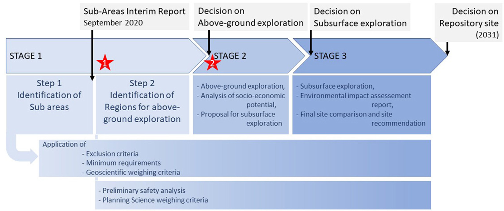
Process of Site selection. Stars indicate the times of public participation: 1—Sub-area conference, 2—Regional conferences. Modified after BGE [Reiche et al. 2021].
Various parties and political institutions are involved in the process (Figure 2): the operating federal company (BGE, Federal Company for Radioactive Waste Disposal), which actively performs the site selection, repository construction and nuclear waste storage. These activities are monitored by a federal authority (BASE, Federal Office for the Safety of Nuclear Waste Management), which also has to ensure public participation. Finally, the German Federal Ministry for the Environment, Nature Conservation, Nuclear Safety and Consumer Protection (BMUV) and the parliament, which makes the final decision. The Site Selection Act also stipulates that the citizens of Germany must be involved. This is achieved by establishing technical conferences, where the above listed parties, scientists and citizens can discuss the preliminary results of specific steps in the selection process. They may also propose their own requests [StandAG 2017].
Parties involved in the site-selection process. Arrows indicate direction of interaction. Modified after [BGE 2020a].
Finally, the Site Selection Act rules that an independent board is installed to oversee all phases of the search process, reviewing all documents, and thus monitoring compliance with the five fundamental principles (NBG, National Citizens’ Oversight Committee). This panel is pluralistically composed by twelve recognized personalities from science and society, who are appointed by the parliament, and six citizens including young people. The citizen representatives are elected out of a pool of randomly addressed and willing persons. All NBG members work on an honorary basis. The panel takes insight in all documents from all involved parties and issues recommendations to stakeholders and the parliament. It is further authorized to commission expert opinions, especially on the basis of economic geological data, which may not be published due to property rights. This right is derived from a law passed specifically on the occasion of the search for a final repository site, which regulates the publication of geological data [GeolDG 2020]. The NBG is part of the lessons learnt from earlier processes and therefore plays a crucial role.
These different parties interact continually during the selection process. While the process scheme looks straightforward, it is actually an iterative procedure which at any time can respond to mistakenly made decisions. Although there is a definite timeline (Figure 1), it is a guiding principle that diligence takes precedence over time pressure.
It goes without saying that the process will be closely supported and driven by independent research at universities and research facilities, e.g. DAEF (German Working Group on Repository Research).
Germany’s State Geological Surveys are involved in the selection process by providing geological data and introducing regional geological expertise. They are, however, not an active part of the site selection.
2.2. Brief geological background of Germany
Following the strategy of screening out the more suitable sites and excluding the less suitable ones, the selection started in 2017 with the so-called “White Map of Germany”. Naturally, this map should increasingly take on color according to the geological characteristics with regard to a possible HLW disposal site. Three rock types are unanimously considered as potential host rocks for HLW: rocksalt, claystone and crystalline rock, all three of which occur in Germany. Therefore, a short overview of the geology in Germany seems advisable. A detailed description can be found in [Meschede and Warr 2019].
Germany can roughly be subdivided into three different geological zones. North Germany, as part of the Central European Depression, is covered by up to 200 m thick unconsolidated remnants from the Pleistocene glaciation period. Locally, sub-glacial channels incise more than 500 m deep into the pre-Pleistocene layers. Among the deep pre-Quaternary sediments, the Permian evaporite formations are of special interest. They occur as flat-bedded salt pillows or as steep salt domes, which have uplifted and partly penetrated the overlying Mesozoic strata. The Gorleben and Morsleben salt domes are prominent examples. Unconsolidated Tertiary and consolidated pre-Tertiary clays are also encountered at relevant depths.
The Low Mountain range, south of the greatest extension of the Pleistocene glaciers, i.e. a line from the Westfalen basin–Hannover–Leipzig, consists of Mesozoic sediments, which are locally penetrated by Tertiary volcanic rocks. The Variscan orogeny is represented by intensively folded metamorphic and igneous rocks (e.g. Black Forest, Bavarian Forest and Ore Mountains). Potential sites in crystalline host rocks are looked up here. The NNE–SSW trending Tertiary Upper-Rhein-Graben is a prominent tectonic structure.
The Alps, which build the southern high mountain border of Germany, accumulated the Tertiary Molasse north of the advancing fold-and-thrust belt. These up to several km thick clastic sediments cover Mesozoic (Jurassic) limestone and clay layers, the latter being potentially interesting for HLW disposal.
2.3. Decision criteria according to the Site Selection Act
In the first step of stage 1 of the selection process (Figure 1) the “White Map” of Germany is restricted to subareas where potential host rocks occur. Areas where one or more out of six exclusion criteria (EC) apply are not considered. These EC address uplift rates, seismic, volcanic, tectonic, and former mining activities. Areas where young groundwater has been encountered are also excluded.
If one or more of the potential host rocks are identified, five minimum requirements (MRs) need to be met by the effective containment zone (eCz), which is defined as that part of a rock mass which, in the case of repository systems based essentially on geological barriers, in interaction with the engineered and geotechnical seals, ensures the safe confinement of the radioactive waste in a repository [StandAG 2017]. The MRs account for depth, thickness, and lateral extent of the eCz, as well as permeability and preservation of its barrier effect (Figure 3). The ranges of these parameters are chosen very broadly at this stage of the procedure to avoid eliminating an area too early due to lack of available data.
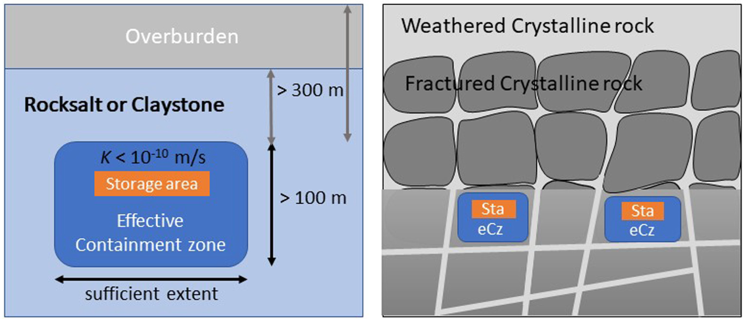
Configuration of host rocks and effective Containment zone (eCz) and Minimum requirements (MR). Left: rocksalt and claystone, right: Crystalline rocks. Modified after [BGR Federal Institute for Geosciences and Natural Resources 2022].
The first step ends by rating the subareas from particularly suitable to less suitable according to 11 geoscientific weighing criteria (gwC). These criteria relate to the following requirements: (i) the achievable quality of enclosure, its robustness and predictability with respect to spatial structure and transport with groundwater, (ii) the protection of the insulation capacity, i.e. tendency to form fissures and potential fluid pathways, and (iii) further safety relevant properties, e.g. temperature resilience, hydrochemical quality or retention capacity for radionuclides.
In the second step of stage 1, all sub areas are subject to “representative preliminary safety investigations” which account for possible technical deposition concepts. Planning weighing criteria (pwC) are first introduced while the gwC are reviewed in more detail. The pwC account for (i) surface features e.g. settlements, shallow aquifers, or flooding areas; (ii) nature conservation areas, deep aquifers or important cultural assets, and (iii) potential mining, geothermal facilities or incident-sensitive assets. The earlier EC, which among others refer to existing mining facilities and young groundwater occurrence, are intended to eliminate potential hazards. The pwC only come into effect in order to decide among geologically equal favorable sites, now considering other future (or past) economic, environmental or cultural value.
Up to the end of stage 1, the site-selection process relies only on existing information, i.e. geological data, bore logs, geophysical sections, maps, 3D-models of the subsurface and—in case that local information is not available—reference data. No specific above ground or subsurface investigations are undertaken yet.
At the end of stage 1, the parliament of Germany has to decide upon sites for above ground exploration in stage 2 based on the recommendation from BGE. Not until the third stage will subsurface explorations and environmental impact assessment be performed. However, stage 2 and 3 will also apply all above sketched criteria with increasing detail, i.e. based on “further” and “comprehensive preliminary safety investigations”. As mentioned earlier, the whole process is intensively supervised by BASE and critically accompanied by NBG. Public participation of citizens is required by law and is achieved through public conferences and various forums.
3. Current results and discussion
Having briefly summarized the process scheme and its selection criteria, the following section will present the recent situation after step 1 in stage 1. Some specific issues and obstacles will be discussed without any claim of completeness.
3.1. Recent situation after step 1 in stage 1, now heading into step 2
On September 28, 2020, the BGE published its first Interim Report on subareas [BGE 2020b] that are identified as suitable, i.e. areas that have not yet been excluded from the site-selection process. This report is viewable on the internet and comes along with an interactive map, where all 90 sub areas can be viewed and its characteristics as well as weighing results can be reviewed.
The Interim Report surprises in terms of two findings: first, the site that had been preferred in the past and that had intensively been investigated, the salt dome Gorleben, is definitely excluded from further considerations. And second: more than half of the area of Germany (54%) is still considered suitable as potential repository site (Figure 4). The size of identified subareas varies between 37,000 km2 (crystalline rocks) covering up to six federal states, and 6 km2 (salt domes). Only the state of Saarland does not have any locations considered suitable. Following the geology of Germany, many clay stone and salt domes occur in the North German basin, whereas crystalline rocks are identified mainly in Saxony, Bavaria and Baden-Württemberg. Prominent clay layers are also described in Baden-Württemberg and Bavaria. Stratiform layered salt formations are found in Thuringia, Brandenburg and Saxony-Anhalt. Some identified subareas extend below the North Sea and the Baltic.

Subareas, status September 28, 2020 (light lilac—Tertiary clay stone, dark lilac—pre-Tertiary claystone, green—salt domes, blue—stratiform layered salt formations, orange—crystalline rock), after [BGE 2020b].
The results presented in the Interim Report have been discussed in public during a series of three sub-area conferences between February and August 2021. A novelty was that the conferences were organized by a preparation group which was built on the basis of democratic election among the potential participants. Another novelty was that due to the pandemic situation, all three conferences were held digitally or at least in a hybrid format. Up to 1000 citizens, scientists, representatives of regional municipalities and environmental or societal organizations debated with the report’s authors (BGE) and the other parties involved in the site-selection process (BASE, NBG). Various thematic sessions had been organized and accompanied by experts on various fields, ranging from geoscience to social science. Participants were able to propose motions, which were voted on democratically. Finally, a report on the discussion results and motions was edited, for further attention by the operative parties BGE and BASE.
The state geological surveys as well as the Federal Geological Survey (BGR) contributed by detailed comments on the identified subareas lying within their responsibility and expertise.
In the meantime, the operative parties BGE and BASE started step 2. One challenging task for the BGE is to further reduce the subareas to regions for above-ground investigations (Figure 1). The new groups of selection tools, preliminary safety investigations and planning weighing criteria (pwC), are used while the previous decision criteria are repeatedly applied. In parallel, additional geological information, that was not yet fully digitally available, needs to be evaluated. Justified criticism of the Interim Report is incorporated into the ongoing work.
According to the Site Selection Act (2017), public participation is not foreseen until areas for above-ground exploration have been designated as Regional conferences. Thus, a participation gap during step 2 in stage 1 exists. Furthermore, only citizens, municipalities and societal organizations in the identified regions are meant here. Therefore, another task resulting from the sub-area conferences has to be resolved by BASE, being responsible for public participation, i.e., a continued format for nationwide public participation which bridges the gap during step 2 in stage 1 needs to be established.
3.2. Selected problems identified at present state of process
In this section, some selected topics that have been critically debated after the publication of the Interim Report will be briefly addressed, without, however, claiming completeness nor sufficient scientific in-depth discussion—be it in natural science or social science terms. Rather, these examples are presented in order to pinpoint crucial issues which might eventually threaten the site selection process due to misunderstandings and decreasing public trust.
3.2.1. Problem seismic activity as exclusion criterion
The Site Selection Act [StandAG 2017] states that the exclusion criterion seismic activity is applied according to seismic zones defined in [DIN EN1998-1/NA:2011-01 2011]. The classification considers macro-seismic intensity hazards, calculated as the 10% probability that a macro-seismic intensity is exceeded once within 50 years. The classification scheme consists of four classes from 0 to 3 [Grünthal 1998]. An area is excluded if it falls into a class greater than 1 (i.e. intensity greater than 7). The actual Sub-area map excludes extensive areas in SW Germany (Black Forest and Swabian Alb), NW Germany (Lower Rhine Bay) and two smaller spots in Bavaria (Alpine foothills) and Thuringia.
With this approach, it is worthwhile to take a closer look at the definition of macro-seismic intensity, which corresponds to the strength of tremor and their effects on buildings and people at ground-surface. An expert opinion obtained by the NBG [Wenzel 2020] concludes that the DIN directive for above-ground buildings cannot assess the potential damage for subsurface structures. Seismic activity may affect the above-ground facilities, which are necessary during the construction phase. Vibrations caused by seismic waves at depths of several 100 m will not affect the subsurface repository except, however, if a fault ruptures the repository directly. Consequently, many countries consider seismic activity as irrelevant to assess the potential risk for subsurface disposal sites, and do not use it as an exclusion criterion [Wenzel 2020]. Alternative risk estimators can be developed. Since, however, the Site Selection Act explicitly specifies the application of [DIN EN1998-1/NA:2011-01 2011], it will need a revision of the Site Selection Act, which in turn requires political action.
3.2.2. Problem: depth of repository as minimum requirement and glacial erosion
One of the MR criteria demands that the eCz must not be at a depth shallower than 300 m (Figure 3). In addition, one of the eleven gwC concerns the protection of the eCz through favorable structure of the overburden against erosion and sub-erosion and their consequences [StandAG 2017].
The results reported in the Interim Report raise debates among scientists as well as in the public. The depth of the eCz considered over a time span of 1 million years will most likely be subject to changes. Erosion, especially from advancing glaciers in future ice ages expected once every 100 thousand years [Hughes and Gibbard 2018], or about ten times within the 1 million-year safety margin, must be considered. As mentioned above, sub-glacial channels are observed in North Germany that cut more than 500 m deep into the bedrock. It can be expected that in future advancing glaciers will erode not only areally but also along sub-glacial channels and can thus destroy the barrier effect of the overburden. Ongoing research is currently investigating the controlling geological factors, e.g. lithology and faults of the subsurface, reactivation of existing channel structures, and predictability of the formation of subglacial channels [Lang et al. 2021].
3.2.3. Problem: host rocks classification and areal delineation of subareas according to structural zones
All three types of potential host rocks bear problems when communicated with non-geoscientists. Salt refers not only to Halite and clay stones not only comprise rocks which are composed of clay minerals and particles smaller than 0.002 mm. However, the term “crystalline rock” seems to be the most misunderstood term on the course of the site selection, even among geoscientists. The Dictionary of Mining, Mineral, and Related Terms [AGI 1997] offers the following definition: “An inexact, but convenient term designating an igneous or metamorphic rock, as opposed to a sedimentary rock.” This in-exactness gives rise to further confusion, especially when communicated to citizens and non-geologists.
Crystalline rocks are any rocks that are made of relatively large mineral grains. These rocks are generally considered as compact and very less permeable. Re-crystallized, coarse-grained marbles, i.e. metamorphosed limestones, however, also belong to crystalline rocks. As soluble calcium carbonate rocks, they are naturally unsuitable as host rocks. Rocks that have experienced high-temperature, high-pressure metamorphosis, are usually referred to as “Gneisses”, and “Granite” is the common term for any plutonic rock, regardless of their mineralogical composition, which ranges from felsic to mafic. Tectonic fracturing and alteration processes by weathering do not affect the classification as “Crystalline rock”, however, they greatly influence the protection capacity against radionuclide transport. Therefore, the identification of subareas as of type “crystalline” bears many obstacles and gives reason for misunderstandings.
Among the seven subareas described as crystalline, the sub-area “Saxothuringikum” is one of the biggest, covering an area of 32,655 km2. It extends from northern Baden-Württemberg eastwards, crossing northern Bavaria, Thuringia, parts of Saxony-Anhalt and finally covering Saxony. The sub-area coincides geographically with the Saxothuringian structural zone. It is only disrupted by small bands or spots, which are not further considered due to EC or MR. This huge structural zone within the Variscan orogeny actually comprises large occurences of plutonic rocks, mostly granites, as well as high metamorphic rocks, i.e. gneiss. However, it is also characterized by Paleozoic schists, which are not favorable in terms of HLW deposition. Consequently, regional geological surveys criticized the delineation of this sub-area along structural borders rather than to lithological characteristics of rocks that are encountered. For example, the Geological Survey of Baden-Württemberg comments that Paleozoic schists are included in the potentially favorable sub-area “Saxothuringikum”, which should have been excluded already at this stage [LGBR 2020].
It can be concluded that the fuzzy understanding of the term “crystalline rock” raises big confusion not only among scientists but even more among citizens, and may thus lower the trust into the selection process and finally the acceptance of a repository. While the problem is most apparent for this big sub-area, the same problems exist for the other two host rock types, which are delineated along stratigraphic extent.
3.2.4. Problem data: availability, suitability for the site selection process and public transparency
The first stage in the German site-selection process (Figure 1) is based on existing information only, i.e. until now no specific investigations in terms of favorability for an HLW repository have been undertaken, except for the sites that had been assigned in the past: e.g. the salt dome Gorleben, or the Asse and Morsleben (for low- and intermediate-level nuclear waste, LILW). Information on the subsurface comprises measured data, e.g. drill-logs, geochemical and hydrochemical analyses, geophysical sections, as well as interpretations, e.g. geological maps and 3D-geological models. Generally, this information is summarized under the term “geological data”. It is one of the tasks of the state geological surveys in Germany to collect and store all regional geological data and information. Within the site-selection process, they have to deliver all relevant data to the BGE.
The operating federal company (BGE) faces a number of obstacles here: apart from various data formats including non-digitized data, which still need to be unified, the geological data have been collected over a time span of decades and thus have different qualities. The spatial distribution of available data is also not uniform. It becomes apparent that regions that were promising in terms of geological resources show a much denser data distribution. Since, however, the aim of resource exploration was not to identify an HLW repository, the measurements may often not exactly provide the needed information. For example, the salt domes in the North German basin are considered as potential oil traps. Therefore, their outer shape is more important for hydrocarbon exploration and can well be estimated by geophysical sections. In terms of the repository, the inner structure and mineralogy of the evaporites in the salt dome is relevant, but was not specifically investigated.
The delineation of potentially favorable rock formations in Germany in the first step of stage 1 is based on checking EC and MR and subsequently weighing geological criteria. One criterion is the potential transport of radionuclides by groundwater in the eCz. Here, the knowledge of parameters, e.g. hydraulic conductivity, porosity diffusion coefficient and sorption parameters, and their spatial variability is crucial, but, not known for the specific region. In those cases, reference data sets, derived from original publications, textbooks or from site investigations abroad are used to define data ranges. The idea at this early step is to apply rather wide limits in order to not exclude areas, before more detailed knowledge is gained. If, for instance for a reference rock, a hydraulic conductivity of less than 10−10 m/s is reported, the potential host rock is still considered “conditionally favorable”; for less than 10−12 m/s, it is seen as “favorable”. Combining the assessment results for all parameters (so called indicators) helps to segregate better favorable from less favorable subareas.
The result of the broad parameter estimation on which the suitability assessment is based is, however, that 54% of Germany’s surface area is currently still identified as potential siting regions (subareas). Whereas the concept was generally accepted by expert opinion, the quality of reference information has been criticized as “partly not state-of the art”. It is, however, also stated that at this early step the site-selection process allows for a rough view, provided that during the repeated application of geological weighing criteria, site-specific information and updated references are used [Kühn 2021].
Another problem is the ownership of geological data and interpretations, e.g. models: especially the exploration data are owned by private companies and may not be publicly available. These data are known to the geological state surveys, and are supplied to the BGE to be used in the site-selection process. However, in order to meet all five main principles of the new selection process, i.e. citizens’ participation, science-based, transparency, self-questioning and learning [StandAG 2017], all selection steps, methods documents, and data must fully be viewable and verifiable to everyone.
This apparent conflict between private ownership and transparency was recently resolved by adopting a new law [GeolDG 2020], which rules the handling of geological data. This law grants the expeditious publication of state geological data while protecting private ownership of exploration data. However, in case of general welfare also those private geological data, which are relevant for the site selection, must be publicly available. The national task to identify an HLW repository site is considered as a case of general welfare. At the current state of the site-selection process, huge amount of information cannot still be publicly viewed due to non-clarified categorization pursuant the Geological Data Act. It has therefore been ruled by the Site Selection Act that in the meantime the members of the National Citizens’ Oversight Committee and their geological experts are exclusively permitted to view and examine unpublished data in a protected data-room provided by the BGE, thus representing the citizens [StandAG 2017].
3.2.5. Problem: how to reduce the big extent of subareas to smaller regions for above ground investigation?
Currently, i.e. in the spring of 2022, the site-selection process is in a crucial step. While the large extent of identified subareas raised serenity on one hand (“The areas are still large, so it is very unlikely that the site will be built in my region!”), it on the other hand raised suspicion of “non-meticulous” work among citizens and professionals. These concerns have been expressed during the sub-area conferences. As mentioned above, expert opinions [Kühn 2021, Wenzel 2020] concur that in the first step of stage 1 the process is justified. However, at the end of the step 2 of stage 1, regions for the above-ground investigations must be proposed, on which the parliament has to decide before the site-selection process can continue in stage 2.
The federal company for radioactive waste disposal (BGE) is currently developing decision strategies on how to further limit the potential areas. Here, the scientists in the BGE benefit from additional digitized data two years after the publication of the Interim-Sub-area Report [BGE 2020b], additional decision criteria which include the technical configuration of the subsurface disposal mine, and numerous professional and citizens’ comments to the Interim Report. Since all subareas in their full extent need to be assessed, the task is immense. The strategies are currently tested at four selected subareas, one fort each host-rock type. These example-sites, so called Regions for the Development of Methods, are chosen according to factors, which can negatively affect the site-selection procedure, e.g. large size of subarea, lack of data, non-uniform data distribution, and lithological heterogeneity.
3.2.6. Problem: comparability of different host rocks
The German site-selection process aims at absolute fairness for all regions, states and municipalities. Subsurface, geological conditions dominate the selection process, rather than political, economic, cultural or infra-structure concerns—these will only be considered at a later stage. Whereas other countries either do not have all three host-rock types or focused their site selection early on a specific type (e.g. Finland: Olkiluoto, crystalline basement; Switzerland: Jurassic Opalinus Clay), the geological conditions in Germany offer all three types spread all over the country. This may be seen as a fortune; however, it puts the problem of comparability. Each potential host rock bears advantages and disadvantages, which cannot linearly be combined in one decision criterion. Above this, each rock type requires individual containment features, be it in terms of spatial configuration, geotechnical and/or technical barriers. So far, the site-selection procedure does not offer any scientifically based method on how to answer the question whether site A in host-rock X, given the containment configuration 1, is more favorable than site B in rock Y with configuration 2. It is this open question that may threaten the success of the site-selection process later.
3.2.7. Problem: continued citizens’ participation
Whereas many geoscientific and safety questions still need to be resolved and planning scientific criteria need to be included before the final decision is made, the novel aspect of full and continuous citizen participation based on maximum transparency is one of the most challenging new requirements, which are formulated in the Site Selection Act [StandAG 2017]. This has been documented by the numerous concerns expressed during the sub-area conferences. While the law is very specific on when and how citizen participation is granted, the meaning of the term “participation” is not clear to all engaged parties.
Participation means the act “of taking part or become involved in something” [Cambridge Dictionary 2022]. “Something” in this context means the selection process. Participation presupposes but is not limited to information and transparency, rather it means that citizens are part of the selection process. That, however, means that everybody must be conditioned such that he or she understands the process and can judge it. It also means that the citizens are no longer just recipients of information and decisions, rather they can independently contribute to information and decisions by their own judgement. In consequence, it is the task of all professional stakeholders to interest citizens and to provide sufficient technical knowledge. This is truly a challenging task, as the average citizen is not a geologist or radiation physicist and an appropriate but non-academic language needs to be used to bring everyone along. Also, it means a lot of personal engagement from the citizens to spend many free time hours over years to actively participate in conferences, advisory groups and discussion fora. As such, the site-selection process is not just a geoscientific-technical process, it also requires a lot of social science expertise.
It is also a question of who is actually addressed? Prospecting an evaluation time span of one million years it needs the engagement of future generations, which have never profited from nuclear power nor experienced the political and societal debates in the past. Here, it is our generation’s task to develop specific formats and new media, to attract young people’s attention, who will soon have to deal with this problem.
As described above, the Site Selection Act provides several participation formats along the process line; however, these are concentrated to specific periods. The first format is the Sub-area conference after the publication of the Interim Report, which was limited to a time span between September 2020 and August 2021. During the sub-area conferences, participants expressed their worries regarding the geoscientific reasoning. However, most concerns are related to the guiding principles of the selection process, i.e. transparency and the possibility of continuous citizens’ participation because the next period of participation only starts after regions for above-ground investigations are determined. The so-called Regional conferences are aimed exclusively at citizens and stakeholders from the designated regions and directly adjacent national or transboundary municipalities, i.e. during the step 2 of stage 1, when the narrowing down of the subareas takes place on the basis of gwC and, if applicable, pwC, as participation formats are not explicitly established by the Site Selection act.
Since this so-called “Participation gap” has been identified during the first sub-area conferences a new bridging format is developed in cooperation between BASE (Federal Office for the Safety of Nuclear Waste Management) and other involved parties, citizens, representatives of societal organizations and municipalities, BGE and NBG, the latter in its surveying role. Establishing this new format requires an open willingness to engage in dialogue and compromise among all parties. However, if successful, it is a powerful tool to enhance trust and acceptance in the site-selection process. Moreover, it documents one of the five principles, i.e. that the site selection must be understood as a learning process.
4. Conclusion
After a series of unsuccessful attempts by Germany to designate a suitable site for the final storage of nuclear waste, a newly designed selection procedure is now being used to identify a site that, compared to all others in Germany, offers the most favorable conditions for safe storage for one million years. Rather than taking a top-bottom approach on a site location, the process is based on democratic principles. In this approach, it reacts to bad experiences from the past and follows Switzerland, where a similar strong anti-nuclear resentment exists.
The site-selection procedure puts the geological suitability at first place, rather than regional socio-economic interests. However, the fact that three potential host rock types need to be considered, many relevant data are not yet available and some selection criteria possibly have to be redefined, makes the site selection very complicated. In consequence, the process is accompanied by many research activities. The research questions comprise subjects like radio-nuclide migration, glacial erosion processes, fissure forming in crystalline rocks and its conceptual modeling, development of numerical and stochastic models in order to simulate Hydraulic–Thermal–Mechanical–Chemical (HTMC) processes, age-dating methodologies, characteristics of clay-minerals or salt slack as a geotechnical barrier, just to mention a few.
The site-selection process is designed such that public participation must be warranted. In order to ensure this as well as the other attributes of the site-selection process, a National Citizens’ oversight committee (NBG) was formed as a novel, and so far, unprecedented instrument of an independent honorary process surveyor. This committee accompanies the entire search process until the site for a repository has been found and the German parliament has decided on it. The members of the NBG are appointed for three years, but can be extended. The NBG detects possible conflicts, acts as a mediator, issues recommendations, and represents the public. Due to its pluralistic internal composition, which includes citizens, young people, natural and social scientists, theologists, retired politicians and non-governmental environmental associations’ representatives, a maximum range of thought impulses is guaranteed.
The site-selection procedure is a task that affects the whole of Germany and its citizens. From a geological perspective, the procedure offers a new wave of geoscientific job opportunities and a new public recognition of geology as an applied science. However, it is also a major societal challenge that carries a strong integrative potential due to the shared commitment. It is the firm conviction of all involved parties that Germany will ultimately operate a repository site that offers optimal safety conditions and that is democratically accepted by German residents. Revisiting Ghislain de Marsily’s quote, it is in this sense, that we do not blame the Federal Republic of Germany—nor any other country—for its attempt to build the best protection “wall” against any environmental hazard, which may stem from careless handling of nuclear waste, now or in future.
Conflicts of interest
The author has no conflict of interest to declare.
Acknowledgments
The author wishes to acknowledge her co-members of the National Citizens’ Oversight Committees and its office for the support while gathering site-selection process documents. The informative web pages of BGE, BASE and BGR were also a great help.