


 CC-BY 4.0
Climate change is often described as a change in the environment that societies must cope with, either by mitigation or adaptation [IPCC, 2022]. It has been well documented that the effects of climate change are intertwined with those of previous environmental practices, potentializing some of their effects and relativizing others, and that the pressure/response dynamics involve numerous feedback loops and responses between socio-economic adaptations and local ecosystems. In fact, as several authors have claimed [Berkes and Folke, 1998, Berkes et al., 2003, Chenorkian, 2017], it is no longer possible to differentiate between the “human” and the “natural” dimensions in environmental approaches, and it is therefore necessary to consider “socio-ecological systems” (SES) or “coupled human and natural systems” (CHANS), as proposed by Liu et al. [2007a,b]. For some authors, in highly anthropized environments, the human factor can no longer be seen as a dimension outside the ecosystem but should be reframed as an inherent component of what is therefore a “single ecosystem” [Chenorkian, 2020]. This interrelation requires interdisciplinary studies, or a holistic approach sometimes referred to as “global ecology”, not in the sense of globalization but as an approach that considers all dimensions of a given SES (ibid.).
Human-environment observatories (OHM) [Chenorkian, 2014, 2020] are frameworks designed to develop such analyses and advance with the understanding of this complexity [Liu et al., 2007a], since they are inherently interdisciplinary, and they allow a long-term perspective on specific socio-ecological systems. Human-environment observatories provide a focus on contemporary events through which new transformations—sometimes dramatic, sometimes subtle—are taking place. They are excellent places to examine how environmental changes are taking shape, but also how societies respond to this change.
The “Pima County human-environment observatory” (OHMi-PC) is one of the 13 “Human-Environment observatories” of the LaBeX DRIIHM1 . Created in 2015, it is located in a region of extreme climatic conditions where a very large palette of ecosystems exists, from the semi-arid Sonoran Desert and grasslands to conifer forests at higher elevations (Figure 1). OHMi-PC was created when an important social conflict arose in response to a new mining project that was to be opened in the Santa Rita mountains. But this conflict is only the visible part of demographic and sociological changes which started in the 1970s and triggered transformations, which are now reconfiguring the local SES. Previously a strong proponent of resource extraction activities that often overshadowed a nascent conservation ethic, Pima County is becoming a place where ecosystems and landscapes are now valued for broader and longer-term goals. As with any societal change, however, the transformation is not an abrupt rupture but a long-going process, and many features of the resource-extractive system are still in place, prompting conflicts and revealing complex feedback and retroaction loops.
The gradient of ecosystems along elevation [modified from Wilder et al., 2021, 2024, figure by Maya Stahl].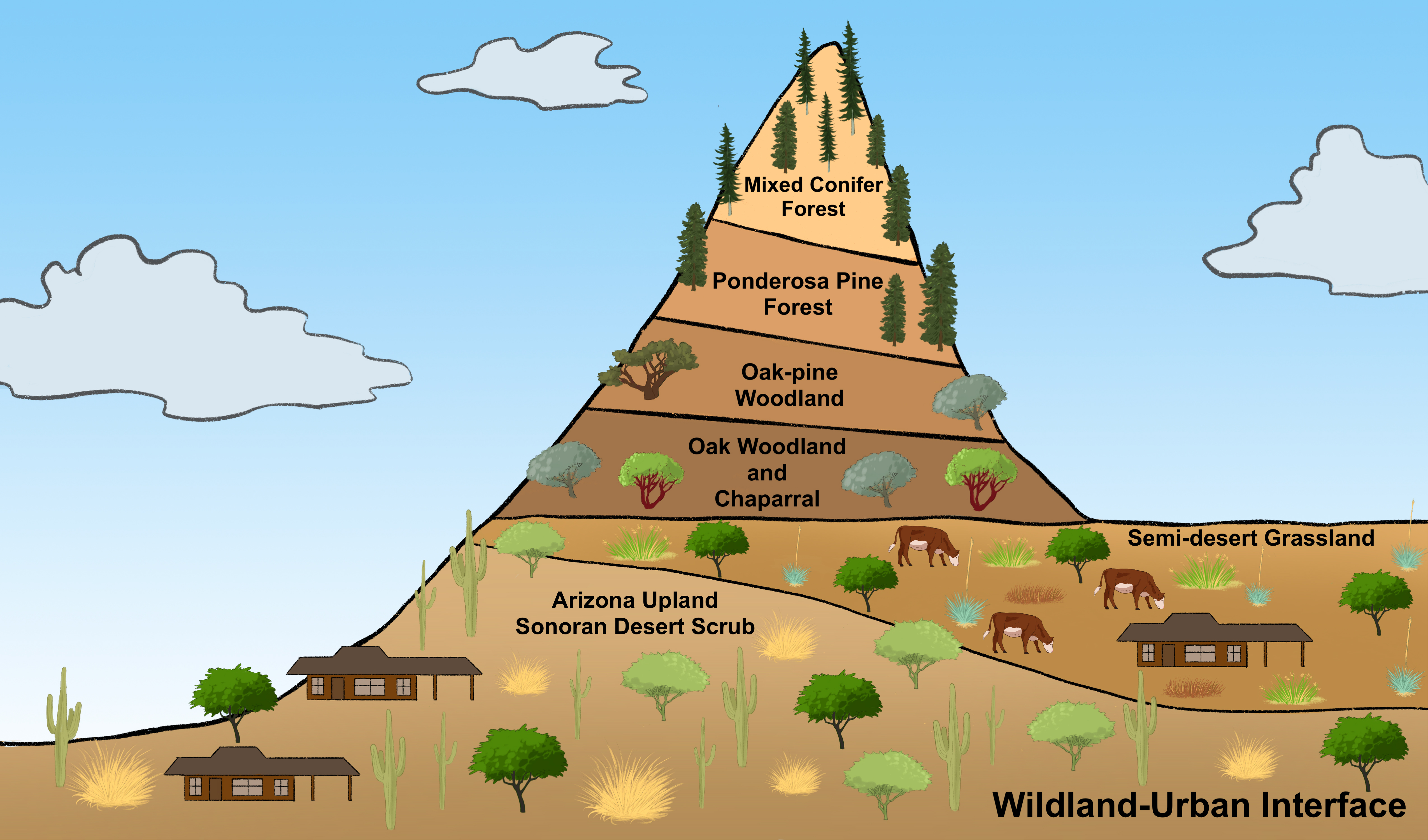
This paper aims to show how the OHMi-PC is instrumental in unveiling the complexity of SES facing climate change. To do so, we will first discuss the socio-ecological setting in Pima County and the crises it has faced in the last decades. We will then formulate the theoretical framework of the “Pima County observatory”, based on the general DRIIHM trilateral approach and the SES framework. We will then demonstrate how the results of three research programs nested within the Pima County observatory exemplify the analyses of complexity in the face of climate change, and how Pima County can be viewed as both an observatory and a sentinel (in the sense of “sentinel territories” developed in Blanchon et al. [2020] of climate change and climate change adaptation.
1. Pima County: environmental extremes and crises
Located in Southeastern Arizona, Pima County is characterized by variable climatic conditions, high endemic biodiversity, and rapid urbanization. The region’s history and development are described by a wealth of ecological and social studies, going back to the early days of Native and European settlement [Sheridan, 2012]. In this section, we show how three major socio-ecological crises that have occurred within the last decades—the 1980s water crisis, the 1990s landscape crisis and the 2010s mining crisis—reflected and prompted changes in the historical socio-ecological setting.
1.1. The socio-ecological framework
Southeastern Arizona is characterized by a semiarid climate. Rainfall is about 300 mm each year with at least 3 months with less than 5 mm of precipitation. Average annual temperature is above 20 °C. Consequently, water is a scare and precious resource, and from the pre-Columbian times to today, human presence has depended on some form of water management. The presence of high-elevation areas typical of the “basin and range” landscape of the western United States, allows for high biodiversity. Mountain ranges, with peaks up to 2800 m, are called “sky islands” because they appear as green forested islands in the middle of a sea of desert grasslands and shrublands [Crist et al., 2014]. Whittaker and Niering [1965], Brusca and Moore [2013] distinguish seven different ecosystems stacked in elevation (Figure 2), each one blending into another in delicate transitions.
While ecological transitions appear to be delicate, contrasts are sharp between elevation extremes Located about 30 km as the crow flies from the center of the city of Tucson, Mount Lemmon enjoys more than 750 mm of rainfall each year (including more than 35 cm of snow), and the average temperature is 10° cooler than in the Tucson basin, yielding environmental conditions similar to those encountered 2000 km further north, at the US-Canada border.
Climate change is having impacts on the region, yielding more intense drought periods and an increase in mean temperatures, during both winter and summer. Among other ecological changes, the movement of species to higher elevations with more favorable conditions can be noted. One conspicuous example is that of mesquite trees (Prosopis spp.), typical of the Sonoran Desert scrub ecosystem, which now invade the grasslands throughout the region [McNew et al., 2023]. Recurring forest fires have been part of the environment of the forests of the US Southwest for at least several centuries [Iniguez et al., 2008, 2016], but have increased in recent years due to drying conditions and historic management practices that have led to a buildup of fuels.
Pima County’s region has been inhabited for over 10,000 years. Indigenous civilizations have taken advantage of the few perennial streams to develop an irrigated agriculture as early as 1500 BCE [Logan, 2002]. Although Spanish explorers made early reconnaissance visits to the area in the sixteenth century, it was only during the eighteenth century that the first settlements were established by European colonists. However, due to its harsh climate, its remoteness from the rest of the Spanish Empire, and regular Apache raids, Southeastern Arizona attracted only limited interest from the Spaniards and from the Mexicans after them.
After the US purchased the territory from Mexico in 18542 , Anglo settlers poured in in greater numbers and started competing with Indigenous peoples for local resources, especially water and grasslands. “Indian wars”, especially with the Apaches, ended in the early 1880s with the defeat of the last bands still contesting the US domination. From this moment on, the Indigenous populations were confined to reserves of limited size compared to their original territories and have undergone waves of colonial erasure up to the present. The Anglo settlers developed an economy based on irrigated agriculture, causing a rapid fall of the groundwater table, and ranching (cattle and sheep), resulting in serious soil erosion. A series of droughts at the beginning of the 20th century exacerbated soil erosion to the point that the federal government passed regulations about the use of public lands. Most of these restrictions are still in place today or were made even more strict over time. The exploitation of public lands is still important in Arizona, where they represent an important share of the state [Le Tourneau, 2019]. Today, only 14% of Pima County is designated as private land; 34% is public land and 42% is designated for Indian reservations (Figure 2, which shows the area observed by OHMi-PC). All remaining ranches use a mix of private and public lands for their operations.
The part of the Santa Cruz river basin observed by the OHMi-PC (white dotted contour) or “focal object” (see Section 2).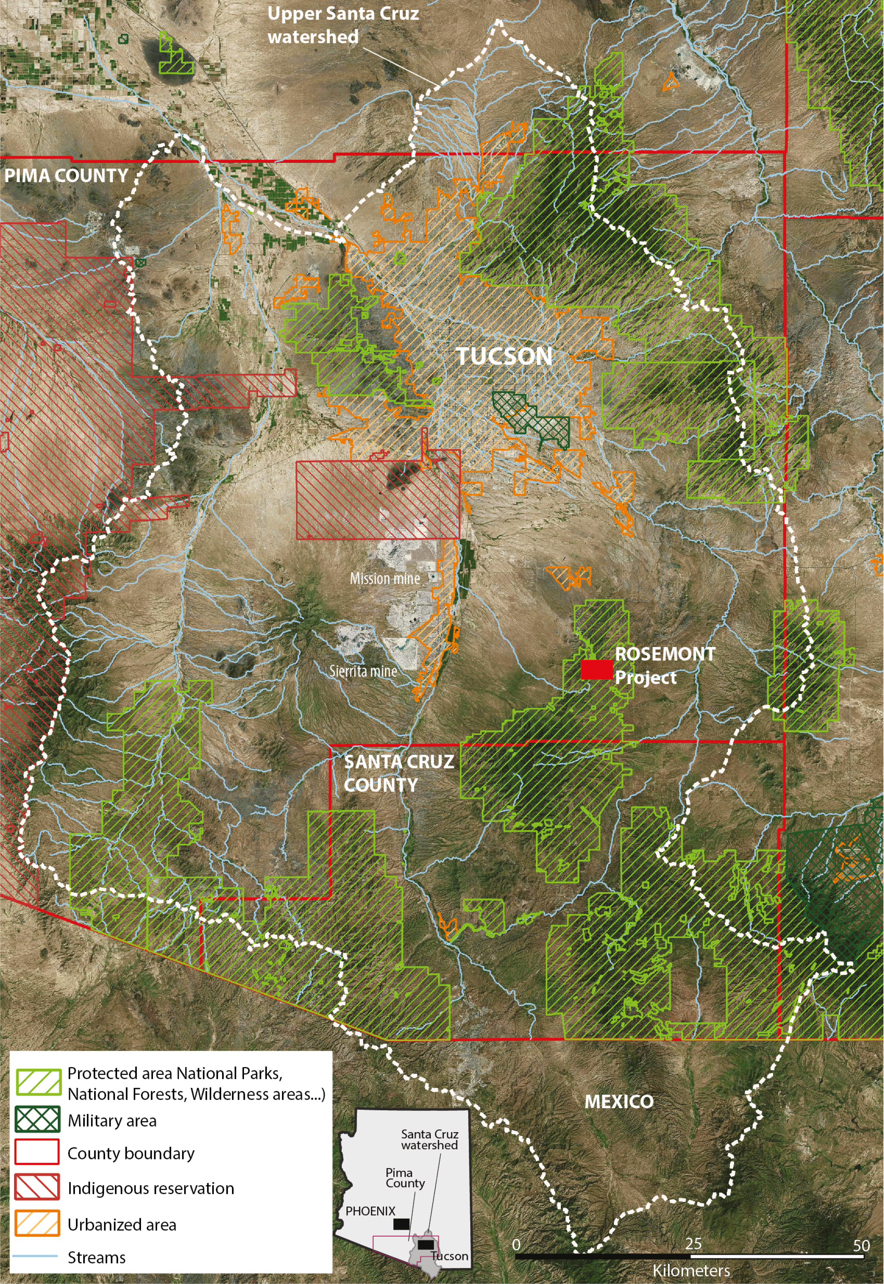
In addition to ranching and irrigation, mining has been a crucial aspect of the economy since the beginning of the 20th century. Although gold and silver were found in Pima county’s mountains, it is copper that assumed the greatest significance. In the 1920s, industrial open-pit mines began operations, and three of them still operate today: Sierrita Mine and Mission Mine near Green Valley (Figure 3) and Silverbell Mine, located West of Tucson. Mining, past or present, is still a prominent feature of the local landscape.
The imprint of mining on Pima County’s landscape: Sierrita and Mission mine, 20 km South of Tucson (source of image: Google Earth).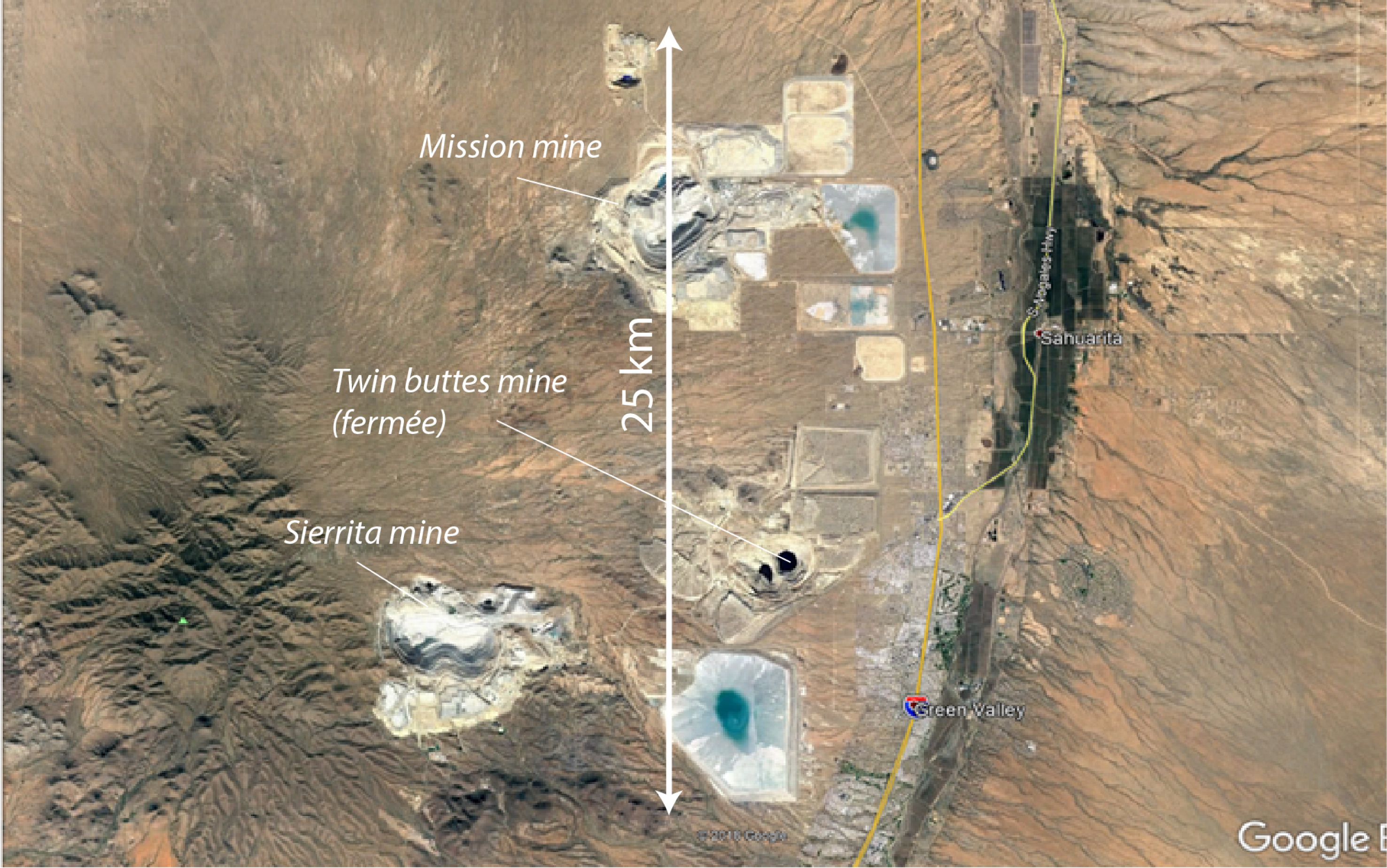
From the 1950s, Pima County’s economy grew steadily with the expansion of air-defense industries, the importance of Davis-Monthan Airbase and the rise of the University of Arizona. The City of Tucson and Pima County have seen steep population increases, and, in consequence, an increase in the urbanized area, largely a result of the attraction of the US middle class to sunny and dry climates, now more easily enjoyable with the popularization of air conditioning and swimming pools. The area covered by urban and suburban developments doubled from 1985 to 2020 [from 602 km2 to 1316 km2, see Dubertret et al., 2022, Figure 4], while the population reached 265,000 inhabitants in 1960, 531,000 in 1980, 843,000 in 2000 and more than 1 million in 2020. This increase in population favored low-density suburban development and sprawling cities, which has had profound impacts on the landscape and natural resources3 . Water consumption also rose dramatically, resulting in more pumping and further decline of the water table [Poupeau et al., 2016, Le Tourneau and Dubertret, 2019]. This decline peaked in the second half of the 20th century, when land subsidence episodes occurred [Zuniga-Teran and Staddon, 2019]. Since then, the region’s main water utility, Tucson Water, has implemented multiple policies to manage water demand. The result has been a decrease in per capita as well as overall water use [Zuniga-Teran and Tortajada, 2021], which, however, remains much higher than in most comparable areas4 .
Urban extension in the upper Santa Cruz watershed from 1986 to 2020 [adapted from Dubertret et al., 2022].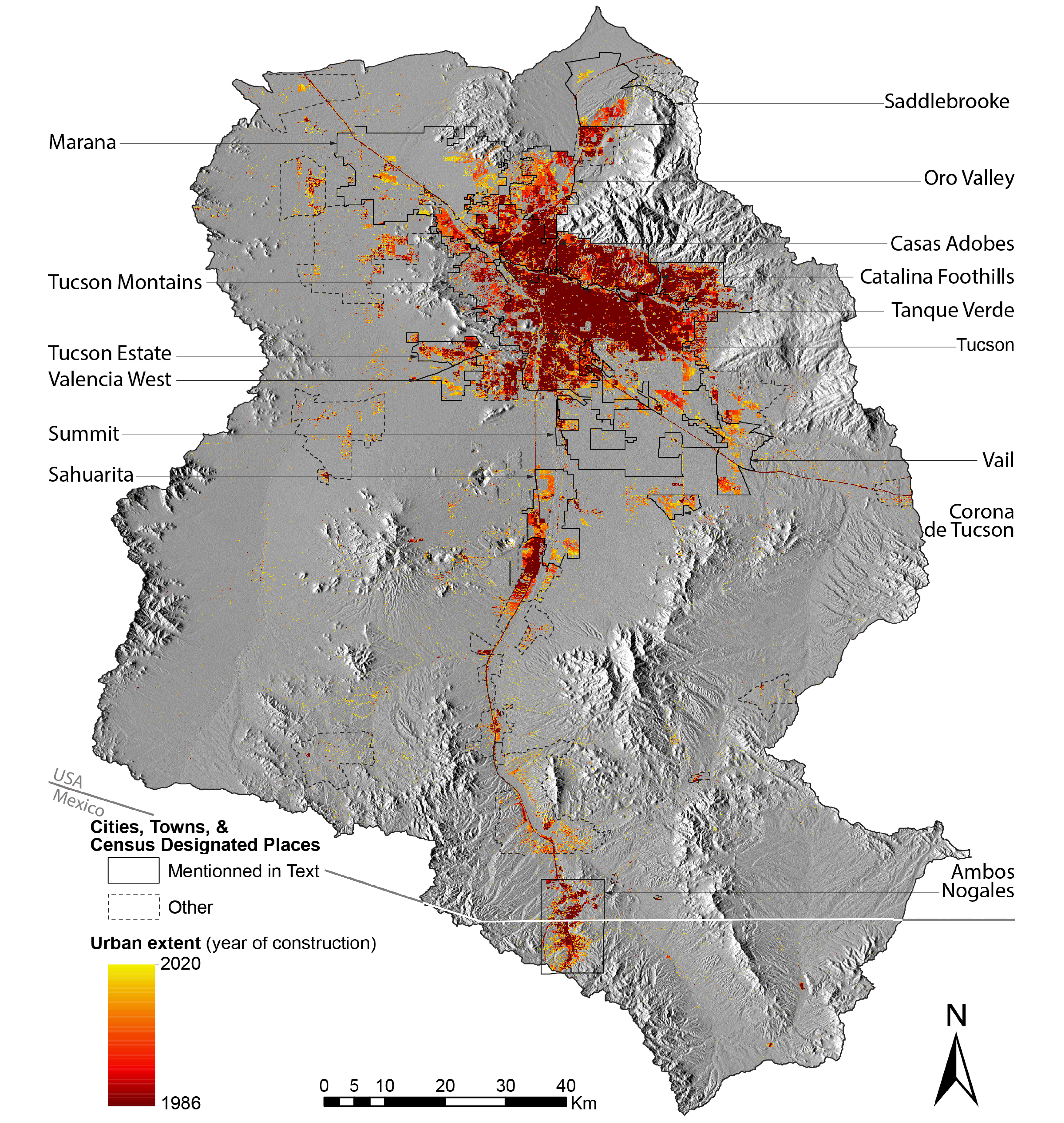
From mining to urbanization, Pima County’s socio-ecological framework has been based on the exploitation of natural resources—grasslands transformed into grazing areas for cattle, mining deposits explored (first on a small scale and then industrially), water use for irrigated agriculture and then for urban uses and finally natural landscape, with the development of extensive low-density areas (urban sprawl). These developments have continued through the 1980s, until a succession of crises made this attitude no longer sustainable.
1.2. From water to mining: socio-ecological crises in Pima County
1.2.1. The 1980s water crisis
At the end of the 1970s, the adverse consequences of groundwater pumping became increasingly apparent in Central and Southeastern Arizona. Poised to diversify its water portfolio and under pressure from the Federal government, which insisted on the adoption of improved water management as a precursor for financing the Central Arizona Project (CAP)5 , the state of Arizona adopted in 1980, the Groundwater Management Act [Poupeau et al., 2016, Engel et al., 2020]. The Act tied the expansion of urban areas to the availability of renewable water supplies and limited the expansion of irrigated agriculture within six Active Management Areas (AMAs)6 and three Irrigated Non-expansion Areas (INAs) [Zuniga-Teran and Tortajada, 2021]. However, these areas cover only a fraction of the southern part of the state, leaving the rest of rural Arizona still exposed to over-pumping.
This water crisis and the legislative framework adopted to resolve it is considered as turning points in the history of Arizona, even if, to a certain degree, it can be debated whether the changes were real or merely band-aid solutions [Euzen and Morehouse, 2014, Cortinas Muñoz and Poupeau, 2019, Engel et al., 2020]. Nevertheless, it clearly signaled the entry into a new era in which water scarcity was acknowledged, reducing decades of groundwater overexploitation and contributing to the redefinition of the socio-ecological framework. Forty years after this initial Act was passed and facing the growing impacts of climate change on the Colorado River, new measures were undertaken through the Drought Contingency Plan (DCP) which increased the pressure on farmers to reduce their water use in exchange for significant monetary compensation.
In urban areas, the consequences of the 1980 water crisis were also significant, with the adoption of new landscaping practices (enforcing the reduction of lawns and other water-thirsty practices), as well as campaigns to reduce the use of water or to promote the use of reclaimed water7 for landscape irrigation. In consequence, the average water consumption by inhabitants has diminished since the 1970s [Benites-Gambirazio et al., 2016]. In 2015, after decades of implementing multiple water policies, Tucson residents used 31% less water per capita than they did in 1989 [Zuniga-Teran and Tortajada, 2021, 2].
Using surface water from the Colorado River via the CAP or through the acquisition of water rights from agricultural farms, Tucson metropolitan area has been able to recharge its local aquifers, and it is currently using them to “bank” or store water for future use [Zuniga-Teran and Staddon, 2019]. However, at the scale of the county, declining water levels and intense pumping are still the rule [Le Tourneau and Dubertret, 2019]. Also, the CAP and water banking policies increases the complexity of the socio-ecosystem, because they link conditions in Pima county to the effects of climate change in the much larger Colorado Basin and because they add another temporal dimension related to the possible use of this “stored” water. Also, the system is based on the idea that water stored in a given place is available everywhere in the basin, which is an oversimplification of the configuration of the aquifer and of aquifer flows.
1.2.2. Landscape crisis in the 1990–2000s
The water crisis has not slowed urban growth in Pima County (Figure 6). In the mid-1990s, the progressive erosion of the natural habitat and the traditional landscapes around Tucson became apparent with the declaration of the cactus ferruginous pygmy owl (Glaucidium brasilianum) as an endangered species. The owl is dependent on saguaro cacti, which are an iconic species of the Sonoran Desert ecosystem. Under the recommendation of federal authorities, local government agencies and a broad coalition of citizens’ groups drafted the Sonoran Desert Conservation Plan (SDCP), adopted in 1998, and the Multi-Species Habitat Conservation Plan (MSHCP), completed in 2016 to preserve habitats, create a conservation land system, and seek to contain urban sprawl [Zuniga-Teran and Staddon, 2019].
The SDCP was followed by an important financial commitment from Pima County residents, as they voted both in 1997 and 2003 to approve $204 million of bond issues, which included the purchase of more than 80,000 ha of ranches (Figure 3) in order to further limit the effects of urbanization. In doing so, the two plans, and the measures taken in their wake, clearly showed that the community viewed landscape transformation as an issue that could result in loss of cultural identity and quality of life, both revealing and trying to solve a “landscape crisis”. The SDCP and MSHCP plans still guide urban development policy today, but they have not halted the growth of urban areas. Since 2010, about 2900 ha have been converted annually to urban development [Dubertret et al., 2022], indicating that the crisis may yet continue.
1.2.3. Mining crisis, 2010–2020
Until the 1970s, Pima County was, at least in part, considered as “mining country”—a place where the exploration of mining deposits was actively promoted. This is evidenced by the presence and continuous operation of world-class mines and the development of urban areas (Sahuarita and Green Valley) in their immediate vicinity (Figure 4), even though pollution and contamination linked to this activity have been well documented [Kim and Harris, 1996, Boyer, 2016]. However, the growing awareness of environmental concerns, linked to water use and landscape change, has compounded this aspect of the local SES and reflected in the intense controversy surrounding the proposed development of a new copper mine (Rosemont mine) in the Santa Rita mountains.
When the mine was first proposed, the project was backed by the Republican-dominated state government and several local stakeholders linked to the mining industry. However, the proposal faced resolute opposition from a broad coalition of environmentalists, the Tohono O’odham Nation, and other stakeholders, including ranchers and tour operators. While many feared that their activities would be negatively impacted by the open-pit mine, all opponents shared the perception of the mine as an unacceptable aggression against the environment and the region’s natural history and heritage [Boyer et al., 2017, Le Gouill et al., 2018]. After years of legal battles8 , the project design was modified to enable access through the Western side of the Santa Rita mountains on private lands owned by the mining company. The public battle of the Rosemont Mine, which continues today, signaled a major change in Pima County’s SES, where the appreciation (and the perceived economic value) of natural landscapes began to outweigh the economic gains from the extraction of natural resources. The conflict also touches on a wide set of issues, including possible impacts on the hydrology of Cienega Creek, one of the last perennial streams of the region.
2. OHMi Pima County as an observatory of the complexity in a “single ecosystem”
OHMi-PC is based on the DRIIHM’s innovative trilateral approach to the concepts of SES and complexity in order to promote a “global ecology approach”.
2.1. Socio-ecosystems and disrupting events: the DRIIHM approach
As Chenorkian [2014, 2017] describes, the DRIIHM scientific framework for the human-environment observatories is based on three fundamental elements. The first is a socio-ecological framework that has been in place for a significant period of time and of significant influence in the area, leading especially to important environmental transformations. The second is a “disrupting event”, always of anthropic origin, which totally or significantly transforms this setting, prompting its reorientation and adaptation. Finally, the third element is a “focal object”, i.e., an area where the socio-ecological framework is deployed and on which, consequently, the effects of the disrupting event are felt. “Human-Environment” observatories have been established in places where these three features are identified. The observatories seek to document how the perturbations related to the disrupting event are absorbed and result either in the adaptation of the previous SES (prompting inquiries about the resilience of such systems) or a new configuration.
2.2. The OHMi-PC defining elements
Pima County corresponds well to the DRIIHM framework. Its environment has been extensively influenced by humans, especially during the last two centuries when a socio-ecological framework emerged based on the extraction or use of natural resources. This framework, has, however, been deeply shaken in the last decades, as evidenced by the conflict around the Rosemont mine project. But this conflict is only the manifestation of changes which have been building through the three crises described in Section 1.
These changes are linked to important demographic and social transformations in Pima County, whose population grew and became more urban and more educated [Sheridan, 2012]. Environmental concerns were already deeply rooted in Tucson, where one of the first US ecological stations (the Desert Botanical Laboratory on Tumamoc Hill established by the Carnegie Institution in 1903) was installed and where, as early as the 1920s and 1930s, protected areas were created [Le Tourneau and Dubertret, 2019]. Tucson has also been home to relatively intense activity by the Sierra Club, one of the United States’ most influential conservation organizations, and by several other local, regional, and national non-profit environmental groups9 . However, these historical precedents did not challenge the predominant development model based on intensive resource extraction until the water (and subsequent landscape and mining) crisis exploded. A different social positioning, until then limited to intellectuals like the well-known writer Edward Abbey10 and small groups of environmentalists, started to spread more largely, contesting the notion of urban sprawl and the priority of economic growth. This change in attitude about the environment, which is echoed in the three crises described above, is considered to be the OHMi-PC’s pivotal disrupting event.
The conflict around the Rosemont Mine is nevertheless viewed as a key catalyst. For the first time, an industrial project was openly opposed through the mobilization of civil society organizations and, even if the mine eventually does open, its exploitation has already been delayed for more than ten years by the large coalition of stakeholders [Boyer et al., 2017, Le Gouill et al., 2018], and its configuration has changed dramatically. Significantly, the coalition against the mine included formerly antagonistic forces, such as ecologists and ranchers [Lacuisse and Poupeau, 2023], which is a proof of change in the community positioning about ecological issues. For most members of the opposition, the environment represents an intrinsic value other than a source of exploitable commodities. There is also a growing awareness of the concept of environmental services, e.g. through the development of eco-tourism and outdoor recreational activities, or the fact that landscape amenities are pushing the price of properties in Pima County, making residents more eager to preserve these landscapes to protect their investments.
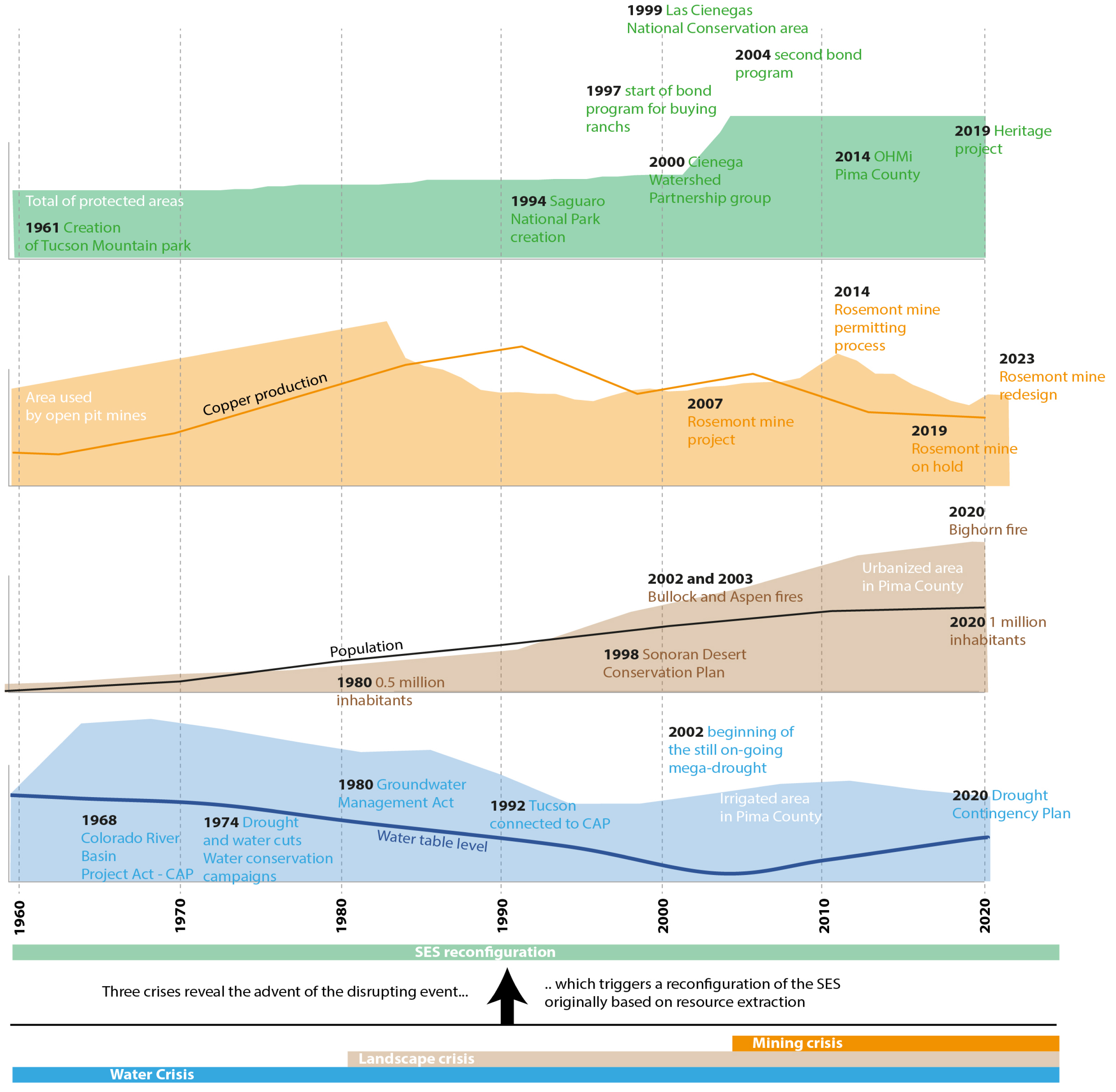
Figure 5 describes the different elements revealing the emergence of the OHMi-PC disrupting event, rooted in the water, landscape and mining crises and made more evident with the conflict around the Rosemont mine. This includes elements of adaptation that illustrate the gradual evolution of a new SES. Overall, we can see the acceleration of events from the 1980s and even more from the 2000s. The “focal object” observed by OHMi-PC correspond to a region which overlaps most part of the upper Santa Cruz river Watershed in Pima and Santa Cruz counties (Figure 2).
A chronological representation of the elements revealing the OHMi-PC disrupting eventa
.
The newly released stream of water of the Santa Cruz River in Tucson (2019).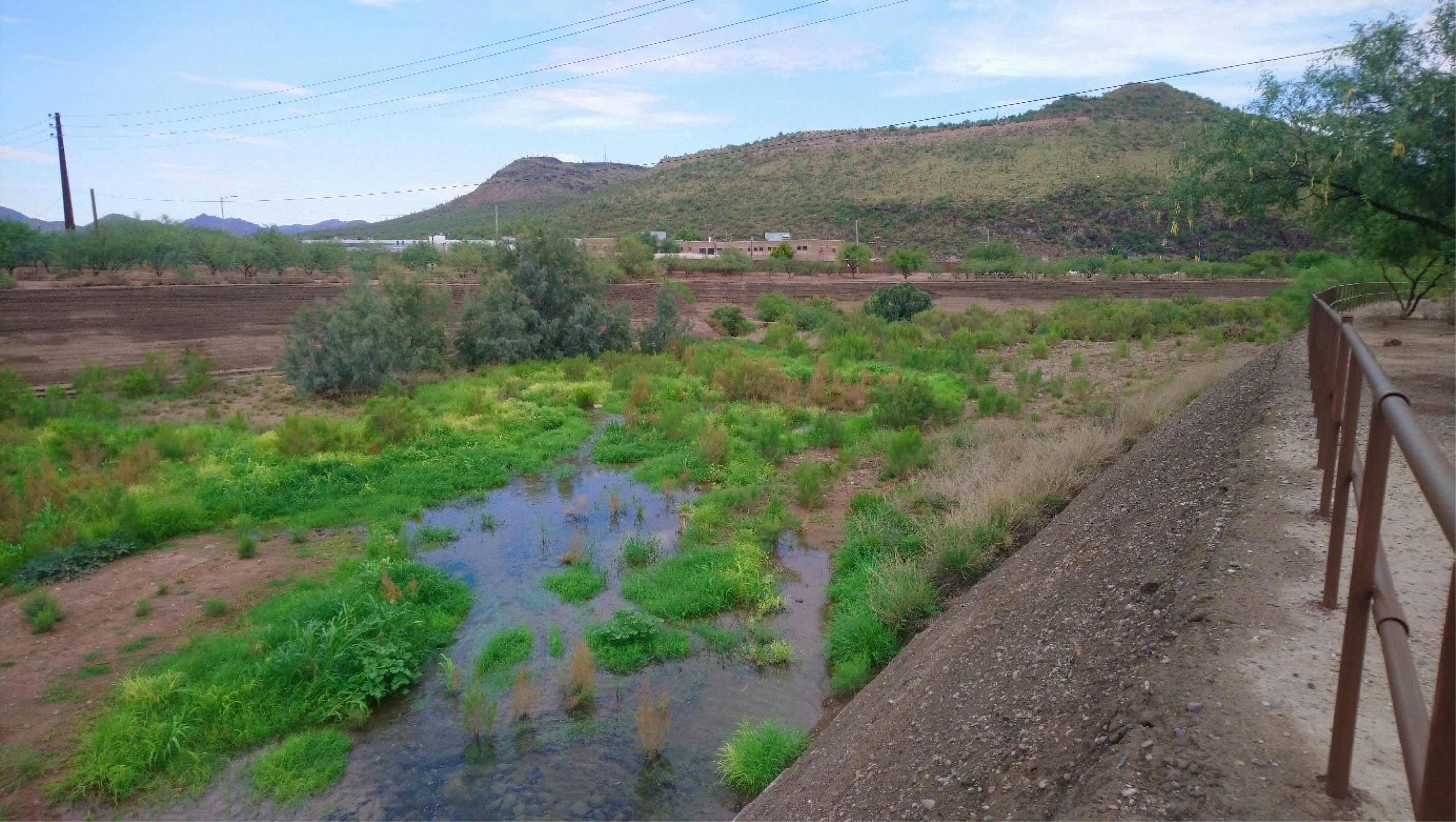
2.3. Complexity and interdisciplinarity at the core of the OHMi-PC action
Human influence on ecosystems has dramatically increased in the 21st century, both in terms of the area it affects directly and in the intensity of its influence, a phenomenon sometimes referred to as the “great acceleration” [McNeill and Engelke, 2016]. In consequence, contemporary studies tend to point out that nature-related and human-related factors are now fundamentally intertwined. Therefore, what is to be studied are coupled human and natural system (or CHANS, see Liu et al. [2007a,b], or even a single socio-ecological system [Berkes et al., 2003, Chenorkian, 2020].
This requires the breaking of disciplinary boundaries or at least significant inter-disciplinary collaboration, since sociology or political ecology help explain biological and ecological transformations. As Liu et al. [2007a] show, approaching SES or CHANS exposes complexity since the interactions that must be described are multidimensional and span multiple spatial and temporal scales, an approach to environmental studies referred to as “global ecology” [Chenorkian, 2020]. As we showcase in Section 3, Human-Environment observatories in general, and the OHMi-PC in particular, are ideal places to analyze this complexity, since their foundational concepts are interdisciplinary and combine environmental science, ecology, biology and social sciences. Examples of how this interdisciplinary approach within OHMi-PC will be developed in Section 3.
As underscored by Chenorkian [2014, 2017], the Human-Environment observatories do not function merely as research programs where pre-defined goals are to be attained and where tasks are set up in advance. They are more accurately described as melting pots, where all disciplines and interests are blended to produce innovative science. From a conceptual point of view, the observatory dynamics are bottom-up as well as top-down, fostering the emergence of new projects within the established framework. The OHMi-PC, as well as the DRIIHM project in general, thus tend to act as ecosystems, staging interactions, retroactions and emergences within their components.
3. From wildfires to water to action: revealing the complexity of human-environment interactions
In this part, we will turn to three examples of research supported by OHMi-PC to showcase its interdisciplinary approach based on the disrupting event identified in Section 2 and explore different aspects of its consequences. There is a progression among these examples. The first, about wildfires, takes what is often viewed as a purely natural phenomenon to show how it is very much influenced by human activity; the second, of the Santa Cruz ecological restoration projects, highlights legacy effects and time lags; the third, about action research in the Cienega Watershed, demonstrates the challenges of engaging in complex analysis while providing useful guidance for collective action.
3.1. (Wild?)fires in the Sonoran Desert: the interplay between climate change and past policies
Fire regimes in Southeastern Arizona are a good example of the complex relationship between human activities and environmental change. As mentioned in Section 1, fires have been part of the ecosystem and their history has been well-documented [Iniguez et al., 2008, 2016]. This long-term history changed dramatically during the 20th century with the United States Department of Agriculture (USDA) Forest Service’s adoption of fire suppression policies. Nevertheless, large wildfires occurred during the early 2000s including the Bullock Fire (2002, 124 km2), the Aspen Fire (2003, 344 km2) and, more recently, the Bighorn Fire (2020, 486 km2).
The reappearance of fires is due to a complex web of natural and human-induced causes. On the one hand, climate change and global warming create more prolonged and intense droughts which make high-elevation forests more vulnerable to fire events. Such changes impact the composition of the forests, with post-fire communities often shifting to novel states [O’Connor et al., 2020]. But the preoccupation with fires also underlines the “landscape crisis” part of the OHMi-PC disrupting event since urban encroachment has put a greater segment of the population at risk.
This vulnerability also stems from the policies and practices that were adopted to protect the forests from fire. With the allocation of public forests for grazing and timber harvesting—as part of the extraction of natural resources bases framework from the 19th century, fire was viewed as a threat to economic activities, and therefore something to be eliminated. Fire brigades and monitoring devices (such as look out towers, now mostly deactivated but still dotting most peaks) and management practices like the opening of roads and trails allowing fire teams to access remote areas and served to drastically reduce wildfires for almost a century. But such success unwittingly paved the way for an aggravated problem. In the absence of regular fire regimes, forested areas began to store a much greater quantity of fuel, especially in the form of dry wood, resulting in longer, hotter, and more intense wildfires and increased tree mortality (and dead trees provide even more fuel for subsequent fires). After many decades of fire suppression communities and institutions favored investments in stronger fire suppression measures (improved monitoring, reinforced fire brigades, new equipment) rather than in policies that allow coexisting with wildfires, such as the use of controlled burns, frequently cited as a better way of avoiding catastrophic events. Another consequence of the efficiency of fire suppression is that communities expanded settlements closer to forest areas, putting them at higher risk and further reinforcing the emphasis on suppression measures.
Following the Bighorn Fire of 2020, studies partially funded by OHMi-PC showed that changes in the fire regime were not restricted to the forest or grassland ecosystems of the Sky Islands, but that they now also impacted the Sonoran Desert, long considered as inherently fireproof [Wilder et al., 2021, 2024]. Invasive species spreading inside the Sonoran Desert ecosystem and competing with endemic species [Betancourt, 2015], is in large part driving this story, especially Buffelgrass (Cenchrus ciliaris), a perennial grass introduced from Africa. First imported and planted to improve pasture in the Mexican part of the Sonoran Desert, it was also used by American ranchers since the 1930s to prevent erosion. Well adapted to aridity, Buffelgrass started to spread, creating thick continuous patches of vegetation and preventing other plants from growing. The continuous carpet of Buffelgrass creates a previously non-existing connectivity of flammable material, meaning that “wildfires driven by invasive grasses can spread from the desert valleys to the forested mountains, and vice versa” [Wilder et al., 2021, 2024]. Dried Buffelgrass also provides fuel that increases fire temperatures and damages other iconic plants such as the Saguaro cactus (Carnegia gigantea).
In the desert habitats, wetter years paradoxically create more fires. During wetter years, grassland vegetation experiences greater growth than usual, and, after drying out during the summer, it creates a thick layer of easily flammable grasses that can rapidly spread fire from one area to another. Simulations run in Wilder et al. [2021, 2024] confirm the anticipated growing impact of Buffelgrass in the coming decades; other studies have noted the lack of success of policies aimed at limiting its spread [Brenner and Franklin, 2017, Lien et al., 2021], particularly on the Mexican side of the border, where ranchers still intentionally plant it.
The issue of wildfires is emblematic of the complexity of SES and the need for interdisciplinary approaches. Fire cannot be understood through a simple analysis where global warming is the main driver of increased fire vulnerability, since human activities and policies have been instrumental in shaping the current situation. Human adaptations and natural phenomena all link into a complex chain of feedbacks and interactions, to the point where it is no longer possible to distinguish between the two dimensions.
Finally, one side of the OHMi-PC “disrupting event” is the greater popularity of environment-related activities like hiking, camping, and bird watching, which relations with fire are not one-sided. Increased use of forest areas can boost the risk of human-triggered fires in the summer, but Wilder et al. [2021, 2024] also observe that small trails in the Sonoran Desert create enough discontinuity in the vegetation to work as fire breaks, a point which should be taken into account.
3.2. Making the Santa Cruz flow again: the ambiguities of “ecological restorations”
As pointed out in Section 1, the area covered by the OHMi-PC has been marked by a water crisis that became apparent in the 1970s. Irrigated agriculture, mining and urban growth have all depended on large-scale pumping, resulting in a steep decline in the water table, which fell by 200 feet from 1952 to 1990 [Le Tourneau and Dubertret, 2019], and in the drying out of formerly perennial streams such as the Santa Cruz River [Lee Wood et al., 1999, Webb et al., 2014]. Water in the Santa Cruz River flows now only a few days each year [Logan, 2002, Webb et al., 2014, Serrat-Capdevila et al., 2016]. The riverbed was relegated to marginalized populations and often used as an informal waste dump, or a “wasted space” [Carré and Le Tourneau, 2016].
If the river was almost erased, its symbolical value remained strong, especially in Arizona where water symbolizes abundance and life. As early as the 1950s, the Nogales International Wastewater Treatment Plant (located in Rio Rico, Arizona) and the Agua Nueva Water Reclamation Facility (in Tucson) released effluent into the riverbed, but these releases were more a source of nuisance (bad smell, bad water quality) than a demonstration of restoration. After 2009, upgrades to the water treatment installations removed the nuisance associated with insufficiently treated wastewater, allowing the rebirth of a functioning river ecosystem, epitomized by the reemergence of an endangered species, the Gila Topminnow (Poeciliopsis occidentalis).
At the end of the decade of 2010, the city of Tucson and its water management agency (Tucson Water) sponsored the development of the Santa Cruz River Heritage Project, which allocates a portion of the reclaimed water that was formerly released downstream from the city center to be released upstream. This creates a flow of water through the downtown area, where people can see and experience a “running river” (Figure 6). While modest, this stream quickly modified the riverbed through the growth of riparian vegetation and the emergence of an aquatic ecosystem11 . Anticipating this transformation, the project also worked to revitalize existing trails for recreation and tourism and to boost economic development of a new “waterfront”. After decades of turning its back on this disappearing river, the city was now trying to restore and embrace it.
These initiatives are manifestations of the OHMi disrupting event, signaling both the acuteness of the water crisis and a new approach to natural resources, aimed at preserving and restoring the environment instead of using it relentlessly. Nevertheless, they also show some limits of this change. As the literature on this topic shows [Higgs, 1997, Dufour and Piégay, 2009, Morandi et al., 2021], ecological restoration aims at recreating functioning ecosystems. In these specific cases, as the water table has not been restored overall, the flow in the riverbed is dependent on the effluents of treatment plants and would vanish without water release. The system that has been (re)created is therefore artificial, even if it now sustains some ecological processes. The amount of water released is dependent upon the immediate consumption of urban areas, which tends to peak in the morning and late afternoon, and to diminish during the nighttime—a sequence that depends exclusively on social cycles.
How much water is available in the long run also depends on geopolitical and local political factors [Néel et al., 2020]. Regarding the first, the Nogales wastewater treatment plant, sited downstream from Nogales on the US side, processes the water from both the American and the Mexican cities of Nogales. The only reason it releases part of the flow is that it is legally owned by Mexico and therefore not available for other uses by the US. But should Mexico decide to build its own plant and treat wastewater currently sent to the US, the volume currently released in the Santa Cruz riverbed in the US could diminish by as much as 80%, which would likely reduce the length of the flow (currently about 20 km) by the same proportion [Zuniga-Teran et al., 2021]. Regarding the second factor, Pima County and the City of Tucson have promoted the use of reclaimed water to irrigate golf courses or lawns, but in doing so they are creating competition for reclaimed water. The more that is spent for such uses, the less that will be available to be freely released into the riverbed. In addition, water conservation practices (e.g., using graywater for landscape irrigation, adopting low-volume toilets and water fixtures), if massively adopted, may reduce the volume of wastewater, and consequently, reclaimed water. Paradoxically, therefore, a more virtuous use of water and reclaimed water would probably be detrimental to the “restoration” of the Santa Cruz River.
Finally, the Santa Cruz River Heritage Project shows how the legacy of previous policies and behaviors can impact new projects. The release of water upstream from the city’s downtown area substantially raised the local water table, which should have been a positive development. But the project also has to deal with an area near the riverbed had previously been used as a landfill potentially contaminated by hazardous waste. As the rise of the water table could lead to the leaching of toxic elements, authorities decided in 2020 to reduce the volume of water to be released by more than half, thereby limiting the ecological potential of the “restoration” process.
Climate change, finally, also modifies the management conditions for the project, by creating a greater number of extreme events like prolonged droughts or intense rainfall. The Santa Cruz River now functions more like a wash (a water-carved gully or channel), characterized by violent flash floods potentially catastrophic to human infrastructure. Consequently, rivers that run through urban areas raise safety concerns for flooding that have prompted the construction of walls along the main channel and the regular removal of sediment from the riverbed [Varady et al., 2021]. Also, violent floods have the potential to convey the finer sediments of the riverbed away12 , leaving it more permeable to the water. In this context, the water table will rise more easily, which will probably call again for a diminution of the volume released by the Heritage project. The restoration of the Santa Cruz River in this stretch is towards that of a marsh, rather than a riparian forest. As we see here, there are complex feedback and retroaction loops between ecological processes, climate change, and policies intended to remedy previous environmental damages. Approaching these issues requires an interdisciplinary approach from geomorphology and sedimentology to climatology and sociology, which is central to the OHMi-PC and the DRIIHM framework.
3.3. Putting research into action: the cienega watershed partnership
Located southeast of Tucson in a region of grassland and woodland above 1200 m in elevation, Cienega Creek is the last remaining perennial (but intermittent) stream in Pima County. The Creek runs through a watershed spanning about 120,000 ha composed principally of public lands (State and Federal) and private properties, some of which have been placed under conservation easements (Figure 7). The federal Bureau of Land Management (BLM) established the Las Cienegas National Conservation Area (LCNCA) in the early 2000s to protect its biological resources while maintaining historic activities like ranching, corresponding to the BLM’s “multiple use” mandate. North of the LCNCA lies a smaller protected area (Cienega Creek Natural Preserve) managed by Pima County, with the objective of contributing to the protection of Tucson’s aquifer. Like the rest of the County the area is impacted by climate change, invasive species, and other challenges like wildfires [Bodner and Robles, 2017, Goodrich et al., 2020].
Land use and land ownership in the Cienega Creek Watershed [Zuniga-Teran et al., 2022].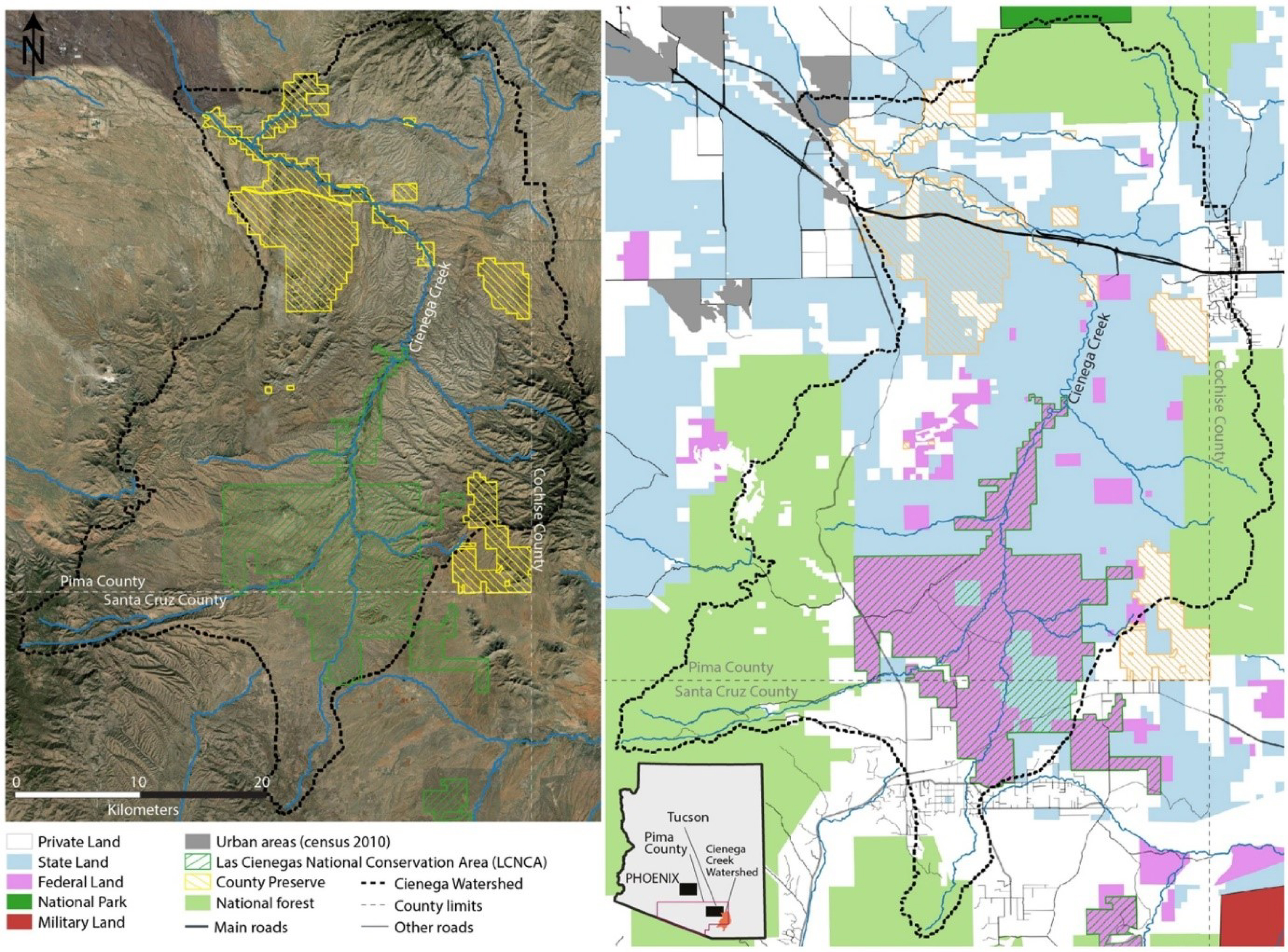
Community engagement in the Cienega Creek area started in the mid-1990s and initially focused on the drafting of the BLM’s Resource Management Plan. At the beginning of the 2000s, the Cienega Watershed Partnership (CWP) was created as a broad-based alliance to support the collaborative adaptive management approach proposed by the BLM [Zuniga-Teran et al., 2022]. Starting in 2008, CWP sponsored an annual meeting, “The State of the Cienega Watershed”, where all stakeholders in the region meet to discuss priorities and actions. But marshaling the different lines of actions of all partners implied the definition of common goals, which, in turn, implied a comprehensive diagnostic of watershed conditions. Therefore, in 2015, the idea of a common set of indicators depicting the overall health of the watershed was adopted. In 2017, CWP partners developed a first set of indicators, collected all the necessary data and produced the first annual assessment. Since 2019, OHMi-PC has supported CWP and its efforts to constantly improve this system, which offers a broader and longer-term perspective on the watershed and challenges all participating agencies and organizations to come to agreement over management decision making.
Currently, the assessment uses 23 indicators grouped into four categories—climate, water, ecological, and socio-cultural (Figure 8). The process of indicator selection reflected some of the challenges of such an endeavor since the lead authors had to reconcile the varied interests of partners and stakeholders. Other challenges included limitations in data availability, the lack of continuity in data gathering methods and measures, issues of scale, and the need to keep the system accessible for partners with more limited technical backgrounds. Overall, the objective is not to provide groups with precise information about their individual interests (they already have the relevant data), but to provide a broader, more comprehensive view of the watershed and to improve coordination and mutual awareness of the interplay and interdependences between all factors, natural or human-related. For this reason, the annual State of the Watershed assessment relies heavily on visual communication aimed at the CWP members and the wider public13 .
Indicators used to guide the action of CWP (Source: CWP report 2021).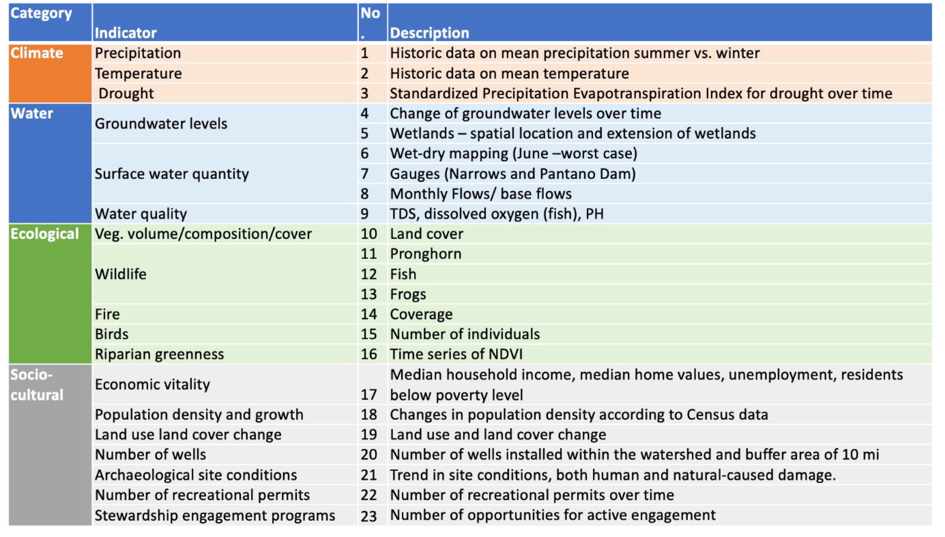
Paradoxically, developing this simplified assessment system reinforced the high degree of complexity in this system. The interpretation of some of the indicators was not as straightforward as one might assume [Zuniga-Teran et al., 2022]. For instance, wildfires are part of the natural history of the area, stimulating growth of vegetation in the grasslands, but they can also devastate features like riparian cottonwood groves and infrastructures. Hence, while fire was viewed as of crucial importance in evaluating ecosystem health, interpreting fire data as positive or negative is in the eye of the beholder. Similarly, the number of recreation permits allows for monitoring the pressure of recreational activities on the ecosystem, but how should these numbers be interpreted? More permits evidently mean more pressure, but fewer permits could also signal less interest, and therefore less public engagement and support, for conservation goals. These discussions underscore the inherent complexity of these phenomena, and the need to use monitoring data to elicit varied interpretations among CWP stakeholders.
The ultimate value of the assessment system is to identify long-term trends and raise the level of awareness of stakeholders about changes that are taking place, an important foundation for both the adaptive management and the collaborative approach that are central to effective management of the Cienega watershed. As natural and human-related causes of environmental change are intertwined, wider issues like water level decline or land cover change due to invasive species encroachment may not result in simple or immediate solutions. But, given the nature of these challenges, collaborative action adds complexity—administrative and jurisdictional, staffing changes, budget constraints, stakeholders’ dynamics and fatigue. Therefore, the key challenge is to close the loop by converting observations like those promoted by the OHMi-PC into a catalyst for concrete action. The pivotal role played by OHMi researchers in the definition of the indicator system as well as the concrete actions carried out within the OHMI-PC/CWP partnership show both the potential of the research-society link and the ability of the DRIIHM framework to foster this discourse. The Cienega Creek watershed is particularly interesting for the OHMi since it combines all three aspects of the water, landscape and mining crises, and shows the reconfiguration of the SES with its innovative coalition constructed around the idea of preserving the environment.
4. Conclusion: from observatory to sentinel?
The OHMi-PC’s “focal object” is a region where climate change effects are already conspicuous because of the arid and highly variable characteristics of its environment. As we have shown in the paper, the DRIIHM framework and the configuration of the OHMi-PC allows for innovative interdisciplinary approaches of different dynamics that are taking place in this region, especially by pointing out how there are many interactions and feedback loops between natural and human-induced phenomena.
As a region that is conscious of change and working continuously to adapt, Pima County is also what Blanchon et al. [2020] call a “sentinel territory”, i.e., “spaces where early-warning signals of environmental threats can be observed. […] sentinels can signal them at the moment they arise and open the way to mitigating lines of action.” (2019: 1). By identifying new fire regimes, by pinpointing the limits and fragilities of restoration processes, or by participating in the definition of the management of a protected area, the OHMi-PC provides important contributions to this ongoing process of raising awareness and helping stakeholders anticipate and cope with change.
Declaration of interests
The authors do not work for, advise, own shares in, or receive funds from any organization that could benefit from this article, and have declared no affiliations other than their research organizations.
1 DRIIHM stands for Device for Interdisciplinary Research on human-environments Interaction (Dispositif de Recherche Interdisciplinaire sur les Interactions Hommes-Milieux). The DRIIHM is a research program coordinated by the French National Center for Scientific Research (CNRS) which is financed by the French Research Agency (ANR) under the “Investissements d’Avenir” program (grant no. ANR-11-LABX-0010).
2 Most of the Western part of the United States was obtained from Mexico after the US-Mexican war of 1848 and the treaty of Guadalupe Hidalgo. However, the territory surrendered by Mexico included only the northern portion of the Gila river. The portion south of the river that is currently part of Arizona and New Mexico was purchased from Mexico in 1853 by the US in order to create an easier path for a transcontinental railroad. The acquisition is named the Gadsden Purchase after James Gadsden, the US ambassador in Mexico who negotiated the treaty.
3 As per the above figures, the developed area of Pima county covers 1316 km2 for 1.04 million persons (including downtown denser area and suburban development), which yields an average density of 793 person/km2, compared with an average suburban only density of 1050 in the US and 2400 in Western Europe (source Demographia.com urban atlas).
4 Le Tourneau and Dubertret [2019] note that domestic water consumption per capita in Arizona is double than the French average, which is somehow surprising given that water is much less abundant in Arizona than in France. The excess in water use in Arizona is mainly explained by landscape irrigation.
5 The CAP is an extensive network of canals and dams which carries the water from the Colorado river to southeastern Arizona, including the city of Tucson.
6 Originally five, and a sixth created in 2022.
7 Which now constitutes about 10% of the water delivered by Tucson Water, see Néel et al. [2020].
8 The most recent episode was a ruling from a federal judge in 2019, confirmed in 2022, who determined that despite the fact that Rosemont Copper Company had the mineral rights on its private parcels, it could not use public land managed by the US Forest Service for dumping mining wastes. The ruling stated that while the 1872 Mining Act does allow for direct use (i.e., mining) on federal lands, it does not include provisions for related activities “in connection with mining operations”, such as the dumping of mining waste.
9 A short list would include the Center for Biological Diversity, the Nature Conservancy, Defenders of Wildlife, Sky Island Alliance, Tucson Audubon Society, Coalition for Sonoran Desert Conservation, Arizona Land and Water Trust, Watershed Management Group, Save the Scenic Santa Ritas, and many others.
10 See, inter alia, Desert Solitaire (1968), The Monkey Wrench Gang (1975), The Fool’s Progress (1988).
a Each curve or surface representation correspond to statistics collected by the observatory. Scales were modified or adapted to match the format. The goal of this figure is not to pinpoint values for each phenomenon but to show the trends and global evolution of each.
11 An additional benefit is that since 2019, water released into riverbeds is given a 95% equivalent credit in the water banking system managed by Arizona. While the water released downstream mainly benefits other areas, those released by the Heritage project directly benefit the city of Tucson in this respect.
12 This happened during the summer 2021 monsoon when more intense rainfalls than usual were recorded.
13 The last version of this assessment (2021) is available on the CWP website (cienega.org): http://www.cienega.org/wp-content/uploads/2021/10/SOW_meeting_2021_long-version.pdf.