


 CC-BY 4.0
1. Introduction
The original causes for the opening of large oceans are difficult to decipher because the conditions of their onset is generally obscured by their later development. On the other hand, marginal basins open as a result of mechanisms which can be identified easily, and include several subduction-related processes encompassing back-arc or forearc setting, and often follow gravity collapse of older existing orogens. In Southeast Asia, many basins have formed in convergence setting and most of them are young enough to have it preserved [Pubellier and Morley 2014; Rangin et al. 1990b], such as the Philippine Sea [Karig 1974], the Sulu Sea [Rangin 1989], the Celebes Sea or the Banda/Damar seas. The extension responsible for the opening is observed on both upper and lower plate, and the rifting/spreading of basins is often coeval with closure of the neighboring ones [Pubellier and Meresse 2013]. The stages of rifting, spreading and the cessation of activity of the SCS basin in Cenozoic appear to be coeval with the progressive closure of the Proto-South China Sea (PSCS) which ended with collision in Borneo and Palawan [Franke et al. 2014; Hall and Breitfeld 2017]. However, if the ages of the rifting stages are relatively well constrained, the dating of the closure is blurred and requires a discussion of the successive regional unconformities.
Mature marginal basins are usually underlain by oceanic crust and are semi-isolated from the open ocean by a tectonic or volcanic ridge [Zhou 2014]. They are formed as a result of several processes encompassing back-arc or fore-arc setting, and deformed by adjacent boundary forces, such as for instance, trench retreat, block rotations or collision [Chenin et al. 2017]. The evolution of the basins, and theirs adjacent structures, can be interpreted from their stratigraphic record. The temporal and spatial variation at regional scale, allows invoking a geodynamic scenario of evolution. Their short-lived cycle also provides easier correlation across short distance between the basin margins and their surrounding tectonic realms.
Many studies had suggested the opening of the SCS, and the closure of the PSCS, took place simultaneously in Cenozoic time [Holloway 1982; Taylor and Hayes 1983; Zhou et al. 1995; Pubellier et al. 2003; Franke et al. 2014; Hall and Breitfeld 2017; Lunt 2019; Li et al. 2020; Lin et al. 2020]. Different geodynamic and boundary forces have been suggested and debated (Figure 1), such as the India-Eurasia collision inducing extrusion of the Indo-China Block [Tapponnier et al. 1982; Briais et al. 1993; Leloup et al. 2001], the opening of a supra-subduction basin [Wu and Suppe 2017; Li et al. 2020; Lin et al. 2020], or a basin opening in the midst of the downgoing plate [Taylor and Hayes 1983; Hall 2002; Pubellier et al. 2003; Morley 2016; Li et al. 2020]. The discussion of the different tectonic models of evolution in East and Southwest South China Sea, although still debated, has been reviewed recently [Morley 2016; Hennig-Breitfeld et al. 2019; Wang et al. 2020].
Schematic models illustrating three possible scenarii for the South China Sea opening. (A) Slab-pull model suggesting a southward subduction of the Proto-South China Sea [Taylor and Hayes 1983; Hall 2002; Pubellier et al. 2003; Morley 2016]. (B) Back-arc model suggesting that the South China Sea opened on the overriding plate while Proto-South China Sea either subducted northward, or was undergoing double-sided subduction [Wu and Suppe 2017; Li et al. 2020; Lin et al. 2020]. A variation of this option is an oceanward subduction followed by a continentward subduction [Larvet et al. 2022]. (C) Block extrusion induced by the India-Eurasia collision which opened the South China Sea along strike-slip fault [Tapponnier et al. 1982; Briais et al. 1993; Leloup et al. 2001].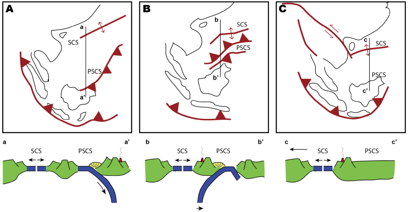
The South China Sea, although a far field product of the subduction, is difficult to consider as a back-arc basin, unless involving a double-verging subduction [Wu and Suppe 2017; Li et al. 2020; Lin et al. 2020], and has been created as the result of tectonics involving either the extrusion of the Indochina block [Tapponnier et al. 1982; Briais et al. 1993; Leloup et al. 2001], or the slab-pull triggered by the southward subduction of the Proto-South China Sea [Taylor and Hayes 1983; Hall 2002; Pubellier et al. 2003; Morley 2016]. Indeed, all these processes have somehow interacted; the global back-arc location of all the marginal basins of Southeast Asia [Rangin et al. 1990a; Pubellier et al. 2003], the existence of the large Red River and Wang Chau strike-slip faults, and the trench pull of the PSCS. The latter of these options was confronted to the observation that no active example exists on earth, although this configuration is admitted for the demise of the successive Tethysian basins, and that it was difficult to model, prior to the studies of Larvet et al. [2022].
In order to approach this issue, this study overviews the tectonic evolution of two marginal seas; the South China Sea (SCS) and the vanished Proto-South China Sea (PSCS), which have been studied extensively in the past decades [Taylor and Hayes 1980, 1983; Holloway 1982; Larsen et al. 2018]. In view of the complexity of the different extensional and contractional features of this paired configuration, the study attempts to establish tectono-stratigraphic correlations across the opposite margins of the SCS, and the PSCS. Various tectonic stages represented by the selected unconformities and integrating multi-disciplinary evidences are combined to reconcile the different hypotheses for the tectonic evolution of this dual system.
2. Geological background
South China Sea is located at the junction between the Eurasia Plate, the Philippine Sea Plate, and the Indian–Australian Plate. Convergence around the Sunda Plate encompasses seismically active plate boundaries such as the Taiwan/Philippines Mobile Belt in the east, the Sumatra subduction zone in the south and east, up to the Himalaya collision in the west. Since Jurassic times, a northward subduction beneath the Eurasia Plate, initiated an extension and a SE migration of the subduction [Yan et al. 2014a; Pubellier and Morley 2014; Li et al. 2018, 2020]. Several intra-plate marginal seas were formed (Figure 2) [Karig et al. 1978; Jolivet et al. 1989; Rangin et al. 1990b; Schellart et al. 2019], in a global setting which is within the upper plate of the Pacific/Indian Ocean subduction system.
Cross-section lithosphere sections across the SCS and the PSCS. (A) Subduction of the Paleo-Pacific Plate went underneath the Eurasia Plate and forming the Proto-SCS as a back-arc setting in Cretaceous. Sampaguita, Kalamansi and Caolao wells are projected reference drill sites. (B) Same section during Late Neogene times.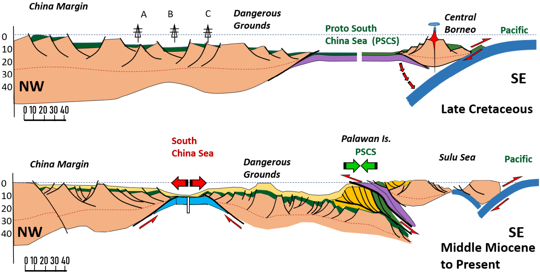
The South China Sea is one of these marginal basins which opened along the SE China and the Vietnam continental margins. Its rifted margins developed along inherited structures, for instance, fold limbs [Savva et al. 2014; Ye et al. 2020], or extensive granite massif [Kudrass et al. 1986; Yan et al. 2014b; Xiao et al. 2019; Miao et al. 2021]. Many syn-rift unconformities are described since the Paleogene, in response to the development of half-grabens marked by detachment faults while the continental crust extended over 600 km in both conjugated margins. A rapid breakup [Larsen et al. 2018], forming a significant V-shaped formed between 32 to 16 Ma [Figure 3, Briais et al. 1993; Le Pourhiet et al. 2018] with a narrow COT and localized magmatism [Nirrengarten et al. 2020]. A diachronous migration of the rifting and seafloor spreading has been proposed [Franke et al. 2014].
(A) Elevation in SE Asia illustrating oceanic basins including SCS: South China Sea, SS: Sulu Sea, CS: Celebes Sea, BS: Banda Sea, BBW: Beibuwan Basin, L: Luconia Basin, NCS: Nam Con Son Basin, NWPB: NW Palawan Basin, PK: Phu Khanh Basin, PRMB: Pearl River Mouth Basin, QDN: Qiongdongnan Basin, SH-Y: Song Hong-Yinggehai Basin, TXN: Taixinan Basin. The bathymetric map has a non-linear color bar to assist in highlighting certain features. Red lines represent the location of seismic profiles and black solid dots represent the locations of the wells. Reference to boreholes; A for Pearl River area, B for “Dangerous Grouds Area (e.g., Sampaguita-1 and Malampaya wells), C for Hainan shelf, E for Nam Con Son (NCS), D for Spratleys Shelf, F for Luconia Shelf. (B) The black dashed lines demonstrate the tentative location of the closure zone of the PSCS [modified from Zhou et al. 2008; Hall 2012; Liu et al. 2014; Zhang et al. 2017].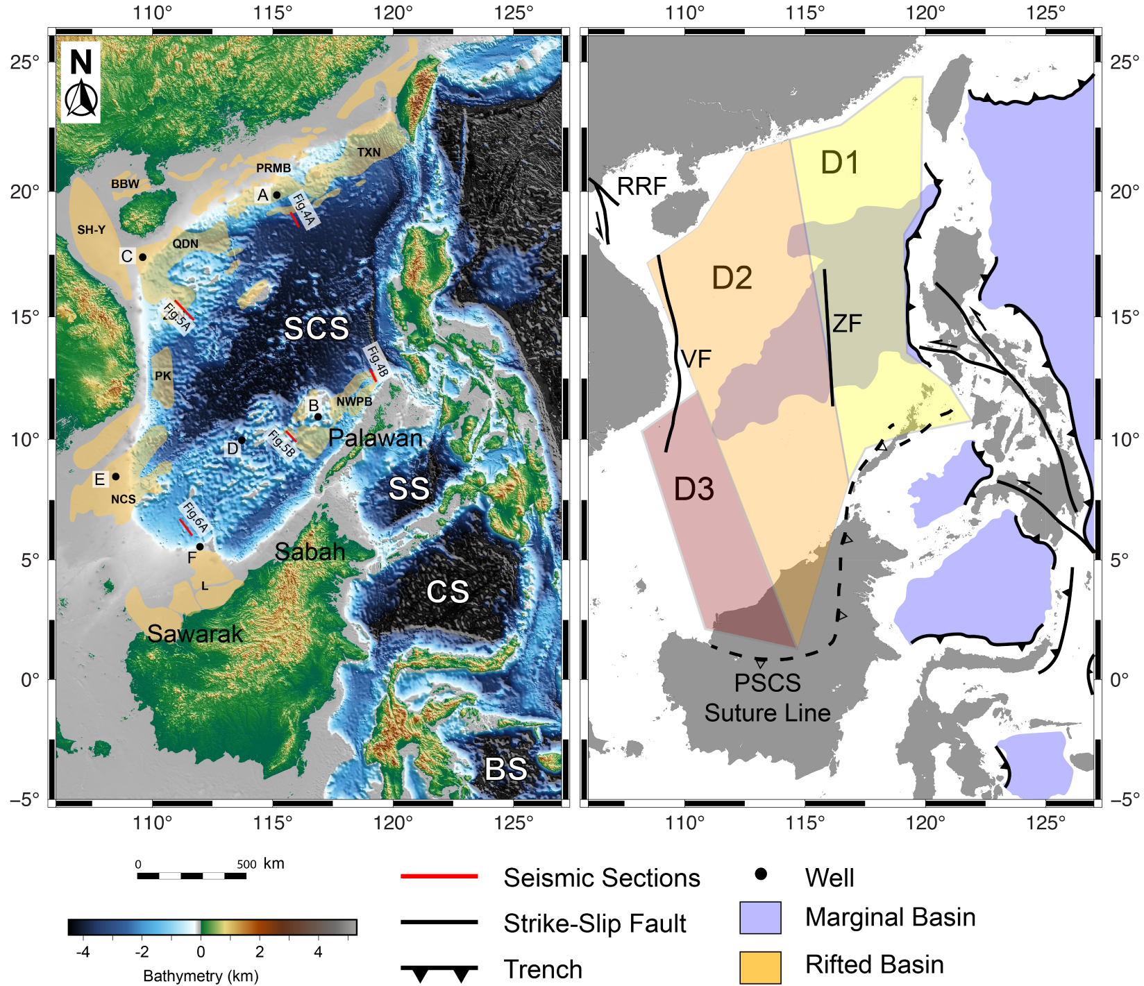
Another basin, known as the Proto South China Sea (PSCS), existed prior to the opening of the SCS, to its SE, but is presently totally subducted [Rangin et al. 1990b; Hall and Breitfeld 2017], and only present as ophiolitic remnants [Omang and Barber 1996; Dycoco et al. 2021]. The ocean-floored Proto-South China Sea (PSCS) was probably formed as a back-arc basin also referred to as the Rajang Sea [Rangin et al. 1990b] although a connection with the easternmost Tethys is possible. The existence of this ancient basin is based on the presence of ophiolite complexes and imbricated fold-and-thrust belt in both NW Borneo and Palawan (Figure 2). The ages of the ophiolites clustered in two main groups as Early Cretaceous and Middle Eocene [Rangin et al. 1990b; Omang and Barber 1996; Graves et al. 2000; Keenan et al. 2016; Chien et al. 2019; Gibaga et al. 2020; Rahmat et al. 2020; Dycoco et al. 2021]. Many stratigraphic hiatuses and changes of sediment sources from the hinterlands reveal successive tectonic events since the Eocene [Cullen 2010; Hennig-Breitfeld et al. 2019]. The termination of the last of these events (Sabah Orogeny) is dated from Late Miocene to Pleistocene [Tongkul 2003; Lunt and Madon 2017; Sapin et al. 2013; Hall and Breitfeld 2017]. Few granite intrusions along Borneo and Palawan suggest the presence of a broken lithospheric slab in Late Miocene [Prouteau et al. 1996; Encarnacion and Mukasa 1997; Hutchison et al. 2000; Cottam et al. 2010; Sapin et al. 2013; Forster et al. 2015].
3. Methodology
This paper reviews the unconformities which are indicators of tectonic instabilities of the margins, but also changes of seismic facies and subsidence history, in three different domains from East to Southwest (D1 to D3 on Figure 3) following Savva et al. [2014]. We extracted key published seismic profiles and wells (locations see Figure 3) to analyze the rift evolution on the grounds of seismic stratigraphy, bio-stratigraphy, and structures. Subsidence history is also examined. In a general, we identify Ro as a “stretching stage” in the sense of Péron-Pinvidic et al. [2007] which is characterized by numerous steeply dipping normal faults, R1 and R2 the thinning stages with an unconformity in the middle (IRU). These rifting stages are followed by the breakup.
In Section 4, the correlation of stratigraphic cuts related to the contraction is established through domains 1 to 3 in order to explore the timing of the collision. Observations in the field onshore and on seismic lines offshore is used to underline and date the crucial convergence-related unconformities. The facies changes in the deposits are also taken into account to evaluate fluctuations in the depositional environment and possible uplift periods. Ultimately, we try to evaluate chronological links between the two opposite margins (Section 6).
4. Tectono-stratigraphy of the rifting and spreading in the South China Sea
4.1. Rifting stratigraphy in Domain 1
On the China margin, the stratigraphy had been established confidently in the past decades according to the intense industrial research exploration.
Within the syn-rift sequence, some internal significant unconformities are found in the Pearl River Mouth Basin (PRMB) in front of Hong-Kong [Chan et al. 2010; Morley 2016; Lunt 2019], as well as in the Tainan Basin SW of Taiwan [Lin et al. 2003]. The timing of breakup and rifting has been interpreted as a diachronous event from east to southwest [Franke et al. 2014]. Although the onset of rifting has been long debated due to insufficient number of drillings [Morley 2016], the age of the detachment fault during rifting, and the age of the breakup show a diachronous evolution as shown on Figure 4 [Franke et al. 2014; Savva et al. 2014]. An early phase of diffuse stretching Ro begins possibly as early as Late Cretaceous [Chan et al. 2010], after the end of the compressional deformation [Nanni et al. 2017] and ended 45 Ma [Xie et al. 2019]. The syn-rift I (R1) was deposited on a basement cut by high-angle normal faults (orange on Figure 4) and bracketed between 45 Ma and 37 Ma [Lin et al. 2003]. An Intra-Rift Unconformity (IRU) separates a second rifting period (R2) from 37 to 32 Ma. It is marked simultaneously on the SE China and Palawan margins by a significant hiatus, and a strong sagging period [Lin et al. 2003; Xie et al. 2019]. This period is characterized by thickly sedimented U-shaped seismic units in the lower part (green to pink horizon on Figure 4), typically expressed in the Liwan sag [Larsen et al. 2018]. The thick R2 represents the last stage of the rifting prior to breakup. Spreading started around 32 Ma [Briais et al. 1993; Larsen et al. 2018; Chao et al. 2021], and ceased at ca. 16 Ma [Briais et al. 1993; Li et al. 2015]. If the extension alone can be invoked for the stretching and thinning of the SE China margin, the southern conjugate margin may in addition have suffered from a flexural fore-bulge effect induced by the subduction in Palawan [Steuer et al. 2014]. The most continuous record at Well Sampaguita-1 documented a stratigraphic boundary formed around 49 Ma between the transition from the shelf to calcareous shale [Taylor and Hayes 1980; Yao et al. 2012]. An extensive unconformity occurred in Sampaguita-1 and Malampaya at 37 Ma [T80; Fournier et al. 2005; Yao et al. 2012; Steuer et al. 2014], and this unconformity can be extended along the seismic profiles showing its distinct distribution in the Offshore Palawan Margin. There, to the south of Domain 1, the breakup unconformity is drawn around 28–30 Ma, possibly indicating a small lag time, or at least an asymmetry for the start of spreading [Nirrengarten et al. 2020]. The age is witnessed by the drilling and seismic evidences [Holloway 1982; Fournier et al. 2005; Franke et al. 2011; Yao et al. 2012; Steuer et al. 2013, 2014; Peng et al. 2020].
Selected portions of seismic lines and major horizons underlying the stratigraphic sequences R1, R2 and R3 discussed in text for Domain 1 (NE of the SCS). Location of the seismic profiles and wells see Figure 3. The intra-rift unconformity (green solid lines) separates the underlain R1 units and the overlying R2 units. The R2 characterizes detachment-related extension and onlapping onto the intra-rift unconformity, corresponding to the acceleration of rifting rate. The breakup unconformity (red solid lines) indicates the breakup time and the incipient seafloor spreading. Subsidence curve modified from Tang et al. [2014], Xie et al. [2014]; Clift et al. [2015]. ROU is the base of R1, IRU is between the 2 thinning events (between R1 and R2), and BU (Breakup Unconformity) marks the end of the rifting and the onset of the spreading at the domain location.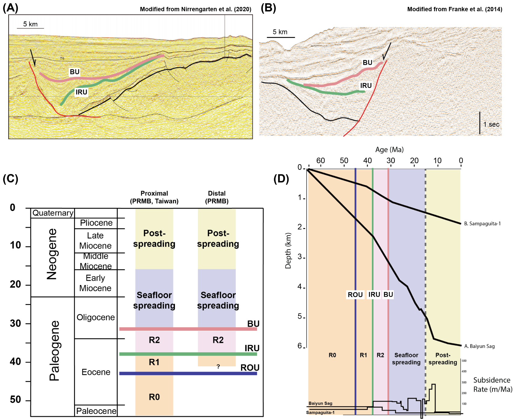
The tectonic subsidence and the subsidence rate are integrated from previous publications [Tang et al. 2014; Xie et al. 2014; Clift et al. 2015], and deduced from the seismic observation. The initial rifting corresponds to the minor subsidence (Figure 4), coinciding the R0 and R1 stratigraphy bounded by high-angle normal faults. The increase of the subsidence rate within the R2 is vigorously related to the detachment faults which thin the crust and generated a Late Eocene unconformity onlapped by the concave-up R2 units in SE China and NW Palawan Margins (Figure 4). This acceleration of extension rate is also suggested in the modelling prior to the rapid breakup in the SCS [Brune et al. 2016; Le Pourhiet et al. 2018].
4.2. Rifting stratigraphy in Domain 2
On the E Vietnam Margin, extension is localized both along sharp segments [Marquis et al. 1997; Roques et al. 1997; Fyhn et al. 2009], and along wide extremely stretched areas showing detachment features [Lei and Ren 2016; Savva et al. 2014; Chang et al. 2022]. Similarly, the southwestern margin also developed extensive basins with detachment faults [Liang et al. 2019] resulting ultimately in an even thinner crust (Figure 5).
Selected portions of seismic lines and major horizons underlying the stratigraphic sequences R1, R2 and R3 discussed in text for Domain 2 (Central part of the SCS). Location of the seismic profiles and wells see Figure 3. ROU is the base of R1, IRU is between the 2 thinning events (between R1 and R2), and BU (Breakup Unconformity) marks the end of the rifting and the onset of the spreading at the domain location).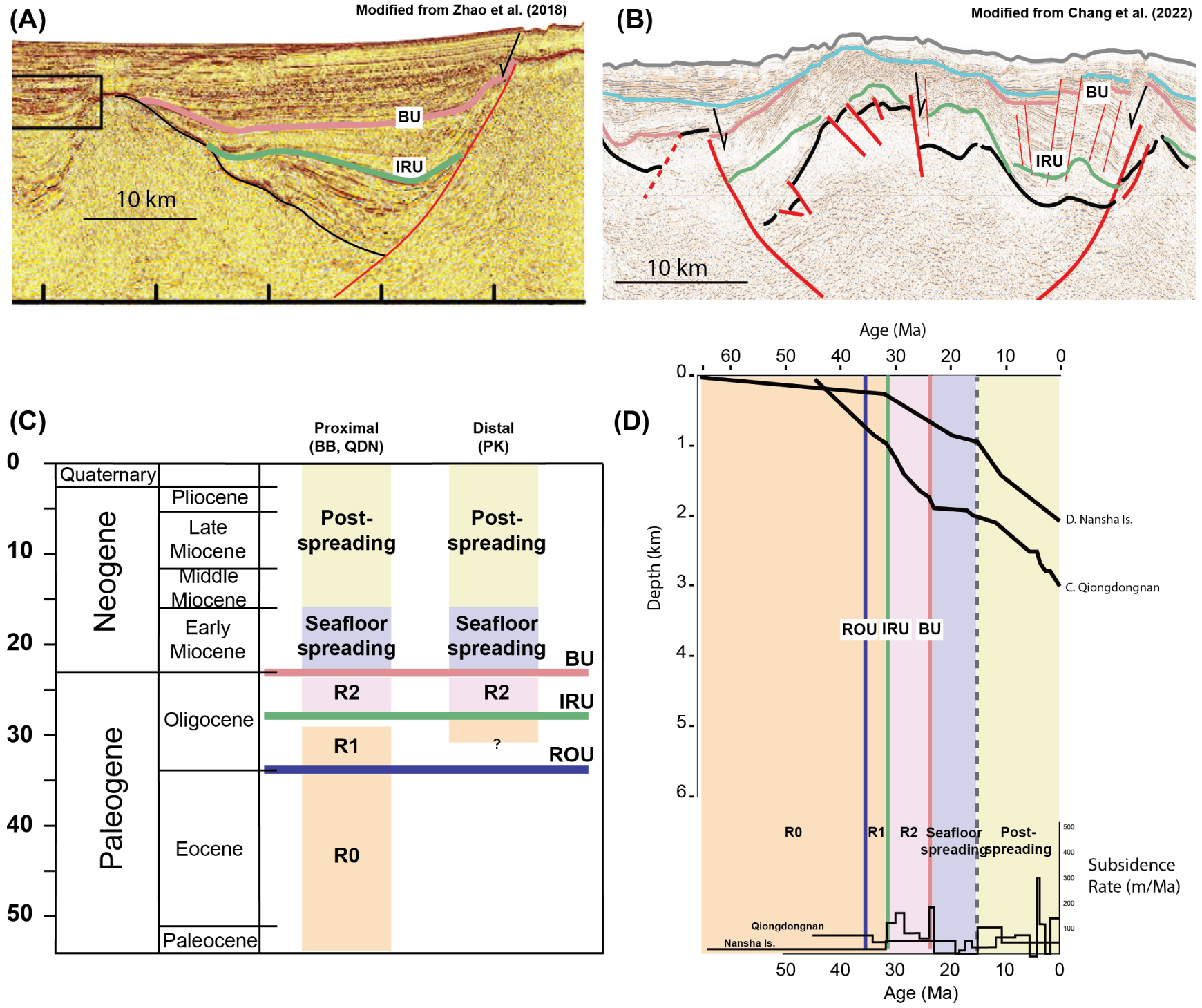
Likewise in Domain 1, the beginning of stretching is unclear (Late Cretaceous?) and ended up at 38 Ma [Lei and Ren 2016]. The distinct ROU (regional onset unconformity) is reported mainly at 37 Ma (T80, bottom of Yacheng Fm.) or slightly older around 45 Ma (within Shixin Fm.), and documented locally around proximal domain such as the Beibuwan Basin or the Qiong Dong Nan Basin [Fyhn et al. 2009; Wu et al. 2009; Savva et al. 2013; Vu et al. 2017; Zhou et al. 2018; Wang et al. 2020, Figure 4]. The intra-rift unconformity (T70, bottom of Linshui Fm.) is an angular one around 28 Ma highlighting the development of detachment faults particularly in both proximal and distal margin such as in PK basin [Savva et al. 2013; Lei and Ren 2016; Chang et al. 2022]. The breakup unconformity is identified as 23 Ma (T60) marking a significant hiatus. In the Dangerous Ground Margin, the earliest unconformity is recorded around 37 Ma and observed within thick syn-rift sequences [Yan and Liu 2004]. An intra-rift unconformity around 30 Ma is observed and dated by biostratigraphy data in the adjacent wells [T7, Hutchison 2004; Yan and Liu 2004; Hutchison and Vijayan 2010; Ding et al. 2014; Zhang et al. 2020]. The breakup unconformity main consensus is around 23 Ma, namely the MMU in many studies [Steuer et al. 2014; Song and Li 2015].
The main character of R2 is its homogeneous upper syn-rift thickness, which correlates well the northern and southern margins. The horizon of upper R2 flattens in several basins (Phu Khanh, Nam Con Son (NCS), and the COT of Nanshan Islands), and is offset slightly by normal faults. This stage illustrates the space accommodation which develops preferably horizontally rather than vertically. The possible age of R2 on the Northern margin is 28 to 23 Ma [Lei and Ren 2016]. In the NW Borneo Margin, the same age of R2 is extracted from the Sampagita Well, although situated just N of the boundary with Domain 1,and its end correlates nicely to that of the incipient oceanic crust [Sibuet et al. 2016; Chang et al. 2022]. The breakup occurred at 23 Ma and the spreading lasted until 16 Ma. Likewise the Domain 1, the forebulge region resulted in a widespread area of shallow-water depositional environment, which developed a significant carbonate layer [Nido carbonates, Hatley 1980; Williams 1997; Steuer et al. 2014]. It is however deepening toward the Borneo-Palawan Trough, although a built-up reef exists along the crest of the horst in the Dangerous Ground area [Jamaludin et al. 2017].
Subsidence curves and subsidence rates from well logging and speculated from seismic lines show a mild subsidence until the middle of the Oligocene corresponding to the R0 and R1 units [Figure 5, Fang et al. 2016; Shi et al. 2017; Zhao et al. 2018]. A stronger subsidence began since 33 Ma and accelerated afterward. This sequence corresponds to R2, and onlaps on the seismic images prior to the breakup unconformity (Figure 5).
4.3. Rifting stratigraphy in Domain 3
In Domain 3, no oceanic crust was developed because the opening of the South China Sea aborted just before the breakup at 16 Ma. The continental crust recorded two stages of rifting and the extensional structures of the NCS and Luconia basins are influenced by the adjacent neighboring mid-ocean ridge [Xia and Zhou 1993; Huchon et al. 2001; Hutchison 2004; Ding et al. 2016; Luo et al. 2021; Madon and Jong 2022]. Several unconformities predated apparently the mature syn-rift units by around 40 Ma and 32 Ma [Matthews et al. 1997; Madon et al. 2013], probably representing the rift onset in this region. One main unconformity suggested the major rifting period from 24 Ma until the extension terminated around 16 Ma as the propagator ceased [Matthews et al. 1997; Madon et al. 2013; Li et al. 2014].
The early stage of rifting is obscured, and R0 and R1 (Cycle I; pre-24 Ma, in the Luconia province offshore Malaysia) cannot be undoubtedly discriminated. The Mesozoic basement was encountered at the bottom of the R0/R1 unit [Areshev et al. 1992; Wu and Yang 1994]. Syn-rift units are separated into two groups (I and II), showing similarities in the NCS and Luconia basins [Franke et al. 2014; Madon et al. 2013; Clerc et al. 2018; Madon and Jong 2022]. Until 23 Ma, The R2 (Cycle II and Cycle III for petroleum geologists of the S margin of the SCS) remains characterized by horizontal to sub-horizontal seismic facies overlying the intra-rift unconformities, but without a breakup unconformity atop [Figure 6, Hutchison 2004; Li et al. 2014; Clerc et al. 2018; Peng et al. 2018]. Most of the normal faults terminate at an horizon dated around 16 Ma [red horizon on Figure 6; Madon et al. 2013; Savva et al. 2014; Li et al. 2014; Lunt 2019].
Selected portions of seismic lines and major horizons underlying the stratigraphic sequences R1, R2 and R3 discussed in text for Domain 3 (NE of the SCS). Location of the seismic profiles and wells see Figure 3. ROU is the base of R1, IRU is between the 2 thinning events (between R1 and R2), and BU (Breakup Unconformity) marks the end of the rifting and the onset of the spreading at the domain location.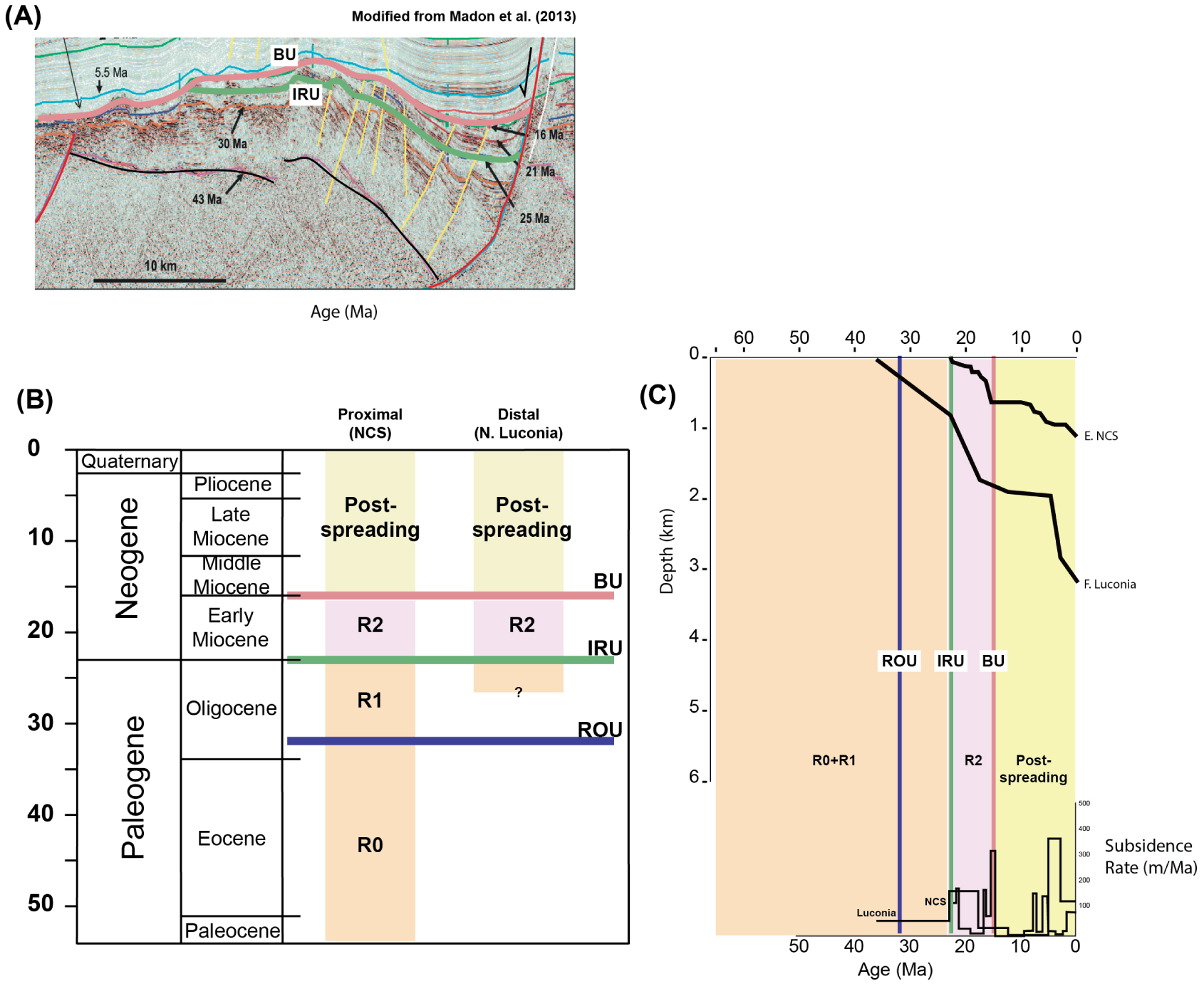
Paleo-water depth gradually deepened by the witness of the well logging and also the pseudo-well [Li et al. 2014; Madon et al. 2013]. Subsidence rate curves did not record the R0 and R1 subsidence curve in the published data. The distinct acceleration found in the previous sections began at 23 Ma, which corresponded to the detachment development, and decreased after 16 Ma both in NCS and Luconia [Figure 6; Li et al. 2014; Jamaludin 2022].
4.4. Diachronous rifting and seafloor spreading in the SCS Margin
According to the above mentioned temporal recording, most of the classical stages of evolution of a margin can be seen in the South China Sea, but appear at a time that varies from D1 to D3. A simple evolutionary age-table is compiled on Figure 7 to illustrate the diachronism of the extensional events. Although the end-members ages of the extension history of the SCS are not significantly different (Late Cretaceous for Ro to 16 Ma for the end of sea-floor spreading), the different markers of the rifting vary from the East to the West. The bracket of ages for R1 to BU is younger toward the south; from 45–32 in D1, 38 to 23 in D2, and 45? to 16 in D3. Indeed, a ridge jump with a shift in spreading direction at 23 Ma [Sibuet et al. 2016] is known and constitutes an important point in time of the extension history. This event marks the end of a rifting style controlled by N–S wrench faults and pull-apart basins [Chang et al. 2022], which marks the early stage of the opening of the SCS, both for the rifting [Chan et al. 2010] and for the spreading [Briais et al. 1993].
Rifting diachronism by juxtaposing D1 to D3. The diachronism appeared from R1 unit and goes on until the termination of seafloor spreading. ROU is the base of R1, IRU is between the 2 thinning events (between R1 and R2), and BU (Breakup Unconformity) marks the end of the rifting and the onset of the spreading at the domain location.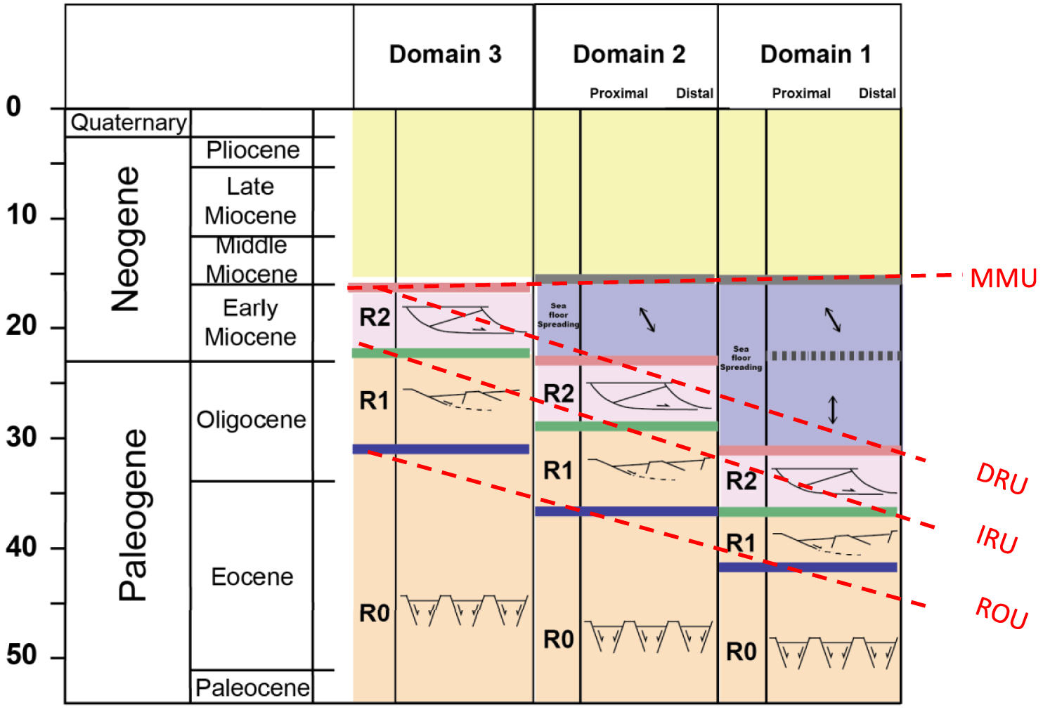
5. Convergent tectono-stratigraphy in Borneo and Palawan
The tectonic evolution of the convergent margin in Borneo and Palawan is also marked by key unconformities which represent different stages of subduction and subsequent collision, as the thinned continental margin of the south of the SCS progressively entered into the subduction zone of the PSCS. In general, the core of the orogenic belt exposes older and metamorphosed rocks of the Cretaceous to Late Eocene Rajang Formation along the backbone in the central Borneo (grey shades in Figure 8). The ophiolitic complexes attributed to the relics of the PSCS are distributed in Palawan and Sabah (purple color in Figure 8) and show two juxtaposed clusters of ages [Eocene and Mesozoic, Burton-Johnson et al. 2020; Dycoco et al. 2021]. The metamorphism and ages of the sedimentary formations decrease outward in the case of the NW and SE Borneo edifices (Figure 8), in accordance to a normal wedge (actually a fold-and-thrust belt) proceeding toward the NW. On the NW side, the imbricated wedge gradually narrow toward Palawan [Aurelio et al. 2014]. This section reviews the stratigraphic unconformities and thermo-chronological data highlighting the initiation of uplift induced by subduction/collision in each domain (D1 to D3). The syn-tectonic and post-collision magmatism is also integrated to assess the closure history of the PSCS.
(Left) Simplified geological map of Borneo and Palawan and main stratigraphic elements for the convergence (Right) Tectono-stratigraphy of the closure of the PSCS from D3 to D1. The segment locations shown in Figure 3. Diachronism illustrated by the beginning of uplift in Sarawak (D3) migrating toward Palawan (D1). The termination of the orogenic event is around 16 Ma.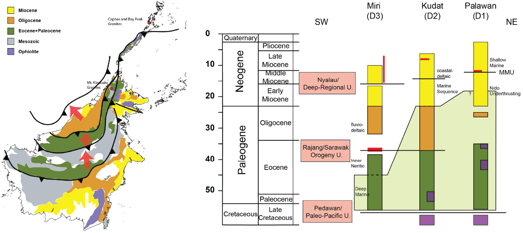
5.1. Tectonic-related stratigraphy in Domain 3
In the Sarawak region, each sedimentary formation has been analyzed in terms of biostratigraphy and detrital zircon [Galin et al. 2017; Hennig-Breitfeld et al. 2019]. The Sarawak Orogeny Unconformity (or Rajang Unconformity, Figure 8) is documented on the ground of a stratigraphic hiatus extensively distributed in central Borneo and along the Bukit Mersing Line separating the Sibu and Miri Zone [Hutchison 2005; Cullen 2010; Hall 2013; van Hattum et al. 2013; Hall and Breitfeld 2017; Hennig-Breitfeld et al. 2019]. After a generally continuous deposition, another widespread unconformity, the Nyalau Unconformity dated around 16 Ma is found [Hennig-Breitfeld et al. 2019].
The Rajang Group mainly consists of deep-sea depositional environment in Sibu Zone (SW Borneo) bearing sediments transported from Kuching hinterland toward the north [Haile 1974; Tan 1979; Bakar et al. 2007; Galin et al. 2017; Hennig-Breitfeld et al. 2019]. The water depth of the deposition appeared have shallowed since 45 Ma without a distinct stratigraphic hiatus in Sarawak [Figure 8, Haile 1974; Tan 1979; Hutchison 1996; Bakar et al. 2007; Galin et al. 2017; Hall and Breitfeld 2017]. The shallowing may suggest an uplift of sedimentary slices induced by the embryonic subduction of the PSCS between 45 and 37 Ma. Acidic magmatism was produced within this period of time [Prouteau et al. 1996]. Above the Late Eocene unconformity, the Nyalau Unconformity is underlain by Neogene strata, which is found in offshore stratigraphy [Hageman 1987], and is characterized by gravity-driven deformation in the offshore fold-and-thrust belt of the Borneo-Palawan Trough.
5.2. Tectonic-related stratigraphy in Domain 2
In Sabah (NW Borneo), the Late Eocene unconformity dated around 37 Ma is similarly found [Cullen 2010; Sapin et al. 2011; Hall 2013], resting on the ophiolite exposed at the surface [Figure 8, Omang and Barber 1996; Graves et al. 2000; Chien et al. 2019; Gibaga et al. 2020]. During latest Eocene to Mid-Miocene, the well-studied Rajang and Crocker groups, constitute the distal and proximal sediments of the PSCS, now thrusted in the NW Borneo wedge. Then During the Miocene, a slight hiatus is recognized around 16 Ma and interpreted as the Deep-Regional Unconformity [DRU, Figure 8, Levell 1987; Tan and Lamy 1990; Hazebroek and Tan 1993; Chang et al. 2019] or the Nyalau Unconformity in Hennig-Breitfeld et al. [2019]. It is followed by the Shallow Regional Unconformity (SRU) dated at Late Miocene in most of Sabah area [Balaguru et al. 2003].
Abundant literature exist on these sediments of the central part of the NW Borneo wedge. The deep-sea sediments of the distal part of the PSCS (Rajang Group) exposed northernmost Borneo (Trusmadi, Kudat Peninsula area) are of early Paleogene. The sediments were transported from the Schwaner granitic province of Southern Borneo, as shown by paleo-current measurements and the prominent peak of detritus zircon [Jackson et al. 2009; Tongkul 2003]. Later, the depositional environment changed from deep-sea to marginal marine or shallow marine in Croker Formation and Setap Shale in Sabah around Oligocene to Early Miocene [Jackson et al. 2009; Zakaria et al. 2013], suggesting a period of uplift in the neighboring land masses. Paleo-drainage reconstructions based on the age population of detrital zircon according to the sediment source suggest the NE–SW backbone in Borneo was extensively uplifted since Miocene, also resulting in the displacement of the paleo-coastline from NW–SE to NE–SW [Menier et al. 2017; Hennig-Breitfeld et al. 2019]. After DRU, horizontal to sub-horizontal strata appear to be restricted to close to the coastline or in the offshore above the Middle Miocene Unconformity (MMU) [Clennell 1996; Cullen 2010; Chang et al. 2019]. The deltaic and nearshore sedimentary input in the large Balingan and Baram deltas indicated thrusting activity by this time was replaced by gravity sliding [Sapin et al. 2012]. During the post-collision period, the gravity-driven deformation involves a late Neogene fold-and-thrust belt in offshore, surrounding circularly the Mount Kinabalu and accompanied with E–W transfer zones in tip of Borneo [Cullen 2010; Franke et al. 2008; Steuer et al. 2014; Chang et al. 2019].
5.3. Tectonic-related stratigraphy in Domain 1
In Palawan, an early Cenozoic structural contact exists between the Cretaceous ophiolite and the Eocene formation, suggesting the absence of the original deep sea sediments overlying the Cretaceous crust of the PSCS [Aurelio et al. 2014; Ilao et al. 2018]. In the offshore Palawan, the ophiolite and its metamorphic sole have been dated at 35 Ma, suggesting that the subduction may have initiated at the PSCS mid-ocean ridge [Keenan et al. 2016; Dycoco et al. 2021]. During the same period, and until the Early Miocene, a significant hiatus is observed onshore (although we have limited formation exposure) (Figure 8). A later extensively distributed unconformity, the (MMU), with a hiatus, seals the deformation around 15–20 Ma of the Nido Platform offshore and onshore. In the past decades, the timing of this MMU was debated due to the discrepancies in age from an area to another and because it may represent the end of the contraction of the wedge as well as the beginning of the gravity sliding period [Hutchison 2004; Ilao et al. 2018].
In more detail, the Eocene stratigraphy (Panas Formation) consists of sandstone interbedded with shale and mudstone showing a deep-sea environment in the early history. With limited information on Oligocene formation, the Nido Carbonate shows the shallow water depth around Late Oligocene [Steuer et al. 2013]. The Isugod Formation commenced receiving the deposits derived from ophiolite while the Panas Formation characterizing deep-sea sediments [Suggate et al. 2014; Shao et al. 2017]. Meanwhile, the Nido Carbonate was thrusted in offshore Palawan, suggesting the timing of uplifting in D1 region by the end of Early Miocene [Cullen et al. 2010; Steuer et al. 2014; Kessler and Jong 2016]. In Palawan, the last stage of deformation is bracketed by the end of the Pagasa wedge post-dating the Nido Limestone (16 Ma) and before the deposition the Tabon Limestone [9 Ma, Taguibao et al. 2012; Ilao et al. 2018]. A gravity-driven structureaffects a narrow belt induced by the shale tectonic in offshore in post-orogeny tectonic [Ilao et al. 2018].
6. Integration SCS and PSCS: correlation of a paired extensional and contractional system
The evolution of the paired system can be assessed by unconformities on the two margins. Although many unconformities are described during the Tertiary evolution of SE Asia, this study selects widespread events of the area encompassing the SCS and PSCS area. In the South China Sea, three main unconformities including the rift-onset unconformity (ROU), the intra-rift unconformity (IRU), and the breakup unconformity (BU) may illustrate in a simple way the diachronism of the rifting process from east to southwest (Figure 9). The extensional events marked by the unconformities are found everywhere on the margins of the SCS but at a different time. In parallel, several main unconformities of the contractional realm of Borneo, illustrate the shortening of the PSCS. Although it is more difficult to pin point the ages of the different stages of the convergence, it is relevant to see if correlation between the opening of a basin and the closure of the other is relevant.
Correlation between the SCS passive margin and the closure of the PSCS. (A) Correlation of rifting events on the SCS margins. (B) Correlation of contractional events on the PSCS, basing on unconformities and deformation in NW Borneo and Palawan Island. (C,D) Two representations of the correlation between the events in the neighboring basins between the Early Eocene and the Middle Miocene. Post Middle Miocene is mostly affected by post-tectonic vertical movements.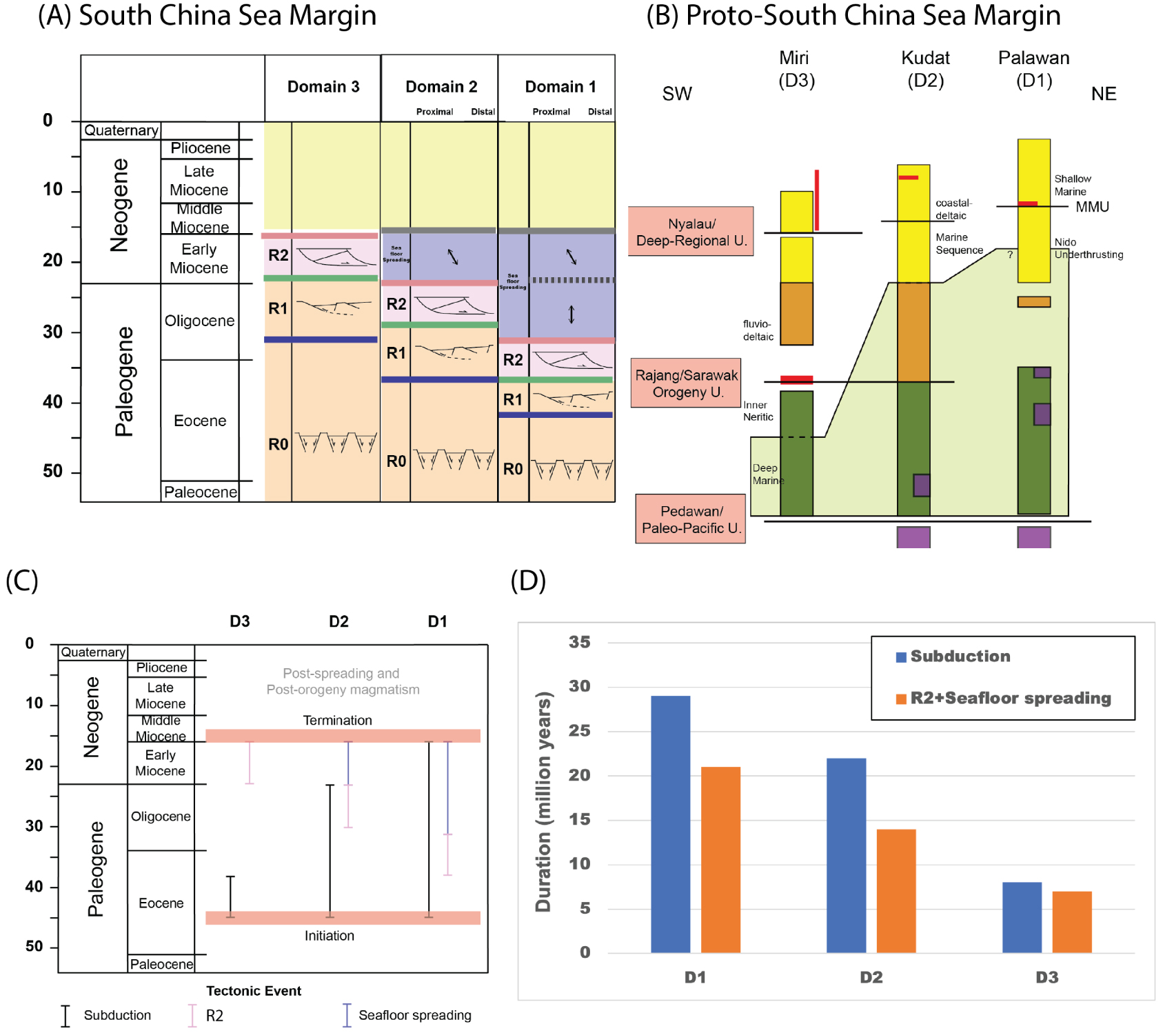
The IRU and the Sarawak Orogeny Unconformity where documented, are located within the Eocene (Figure 9). The latest Oligocene (23 Ma) highlights the initiation of shifting the extensional direction in the SCS, and the related unconformity (Top Croker Unconformity—TCU) can be traced widespread c. 23 Ma [Briais et al. 1993; Sibuet et al. 2016; Lunt 2019, and reference herein]. In the SCS, N–S rifting direction and seafloor spreading lasted until 23 Ma and changed progressively to a NW–SE direction. Precisions for the shift is recorded by a total of 30° between the final rifting in N–S direction and the oceanic formation in NW–SE direction (Figure 9), and is seen in the magnetic anomalies and the bathymetry on oceanic crust [Briais et al. 1993; Lee and Lawver 1995; Sibuet et al. 2016]. It is also seen in the structural mapping of the Phu Khank Basin [Savva et al. 2013]. This modification was interpreted as a ridge jump in the oceanic formation. The counterclockwise change is however relatively less obvious in the East Sub-Basin.
The next unconformity, known as the deep-regional unconformity (DRU) or Middle-Miocene Unconformity (MMU), has been documented and debated for decades. It marks the termination of orogeny in Borneo and Palawan [Ilao et al. 2018; Chang et al. 2019]. Chang et al. [2019] suggested that this unconformity is diachronous along the collision zone, which is dated at 16 Ma in Sarawak and appears northward around Palawan at c. 12 Ma [Steuer et al. 2014].
After the cessation of the opening, the SRU appeared extensively in Sabah and also the MMU in the offshore Palawan. Mobile shale was remobilized [Chang et al. 2019]. This period is also marked by several unconformities which are rather related to magmatism. They are for instance the Mount Kinabalu in Sabah, the Mount Capoas in the northern Palawan, and intra-plate Scarborough seamounts.
6.1. Temporality of events on reconstructions
The succession of events around the South China Sea shows striking indicators of correlation, but also of discrepancies. The global picture is that there is a general time-link between the subduction and closure of a basin, or a series of small basins, located south of the South China Sea (referred to as the Proto South China Sea), and the timing of rifting, spreading, change of spreading direction, and cessation of spreading followed by bathymetric collapse. The second order is that the precise review of the ages actually shows a migration of both the opening of the SCS and the subduction of the PSCS followed by the collision in NE Borneo. We illustrate this proposition in a series of simple sections and sketch maps (Figure 10).
Schematic joint evolution of the PSCS/SCS; (A) opening of the PSCS as a back-arc basin. (B) Beginning of closure in N. Borneo and incipient rifting of the SCS. (C) Subduction of the PSCS. Right: beginning of rifting of the SCS and incipient sea floor spreading of the SCS in the Xisha Trough. (D) Shift in opening of the SCS (propagation of the SW sub-basin), following the subduction of the thinned continental margin of the SCS, beginning of the rotation of N. Borneo. (E) Suture of the PSCS basin and beginning of the opening of the Sulu Sea. (F) Post-collision setting in N. Borneo, with plutonic activity (Kinabalu Mt) and opening of the Sulu Sea propagating toward the SW. Arrow for the rotation of Borneo. Solid and open triangles for active and extinct subduction. Red dots for plutons.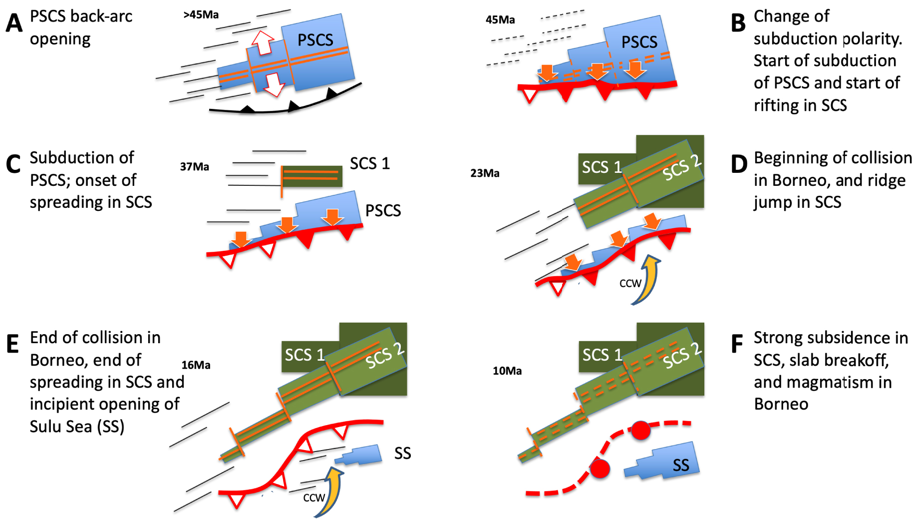
6.1.1. Before the Eocene times (Figure 10 top left)
The first-stage rifting of the margins in the SCS is well documented with an early extension starting from the end of the Cretaceous to the Paleocene. The rifting occurred from SCS extending toward NE to the East China Sea [Teng and Lin 2004; Guan et al. 2016; Cheng et al. 2021]. During this period, the oceanic crust of PSCS was located to the south that juxtaposed with Dangerous Ground and the Borneo.
6.1.2. During Eocene to Oligocene (45–23 Ma)
The subduction initiated in Borneo and Palawan (Figure 10 top right), resulting in the beginning of developing detachment faults to accelerate thinning the continental crusts in the SCS. The crustal architectures suggest extensive development of the detachment faults associating the dramatic subsidence solely in the SCS while no similar impact on the East China Sea. While the collision occurred in Sarawak, the Sabah and Palawan areas continued subduction coincided the beginning of the rapid breakup in the East Sub-Basin in the SCS, following the hyperextension stages around 32 Ma. The first propagator migrating from East to West, stalling near the edge of the former granitic arc, with a slight E–W compression [Le Pourhiet et al. 2018]. The Southwest of the SCS continued the rifting, developing detachment faults in the main half grabens [Savva et al. 2013; Chang et al. 2022; Madon and Jong 2022], mostly in N–S direction extension (Figure 10 top right).
6.1.3. The latest Oligocene (23 Ma) and early Miocene (23–16 Ma)
Highlight the shift of extensional direction in the SCS and the block rotation in Borneo. The spreading propagator continued operating southwestward and the spreading rate decreased from 25 to 15 mm⋅yr−1 in half spreading rate until it stopped at 16 Ma [Briais et al. 1993; Deng et al. 2018; Sibuet et al. 2016]. This may reflect a regional deceleration on both margins of the subduction-driven process. This rearrangement modified accordingly the extensional direction in the vicinity of Spratly Islands and also the Phu Khann Basin [Savva et al. 2013; Chang et al. 2022]. The mountain ranges progressively migrated northward to the Sabah region and modified the river drainages, suggesting the frontal wedge proceeding NW toward direction in Sabah and Palawan. The development of CCW rotation was accommodated by the trench which also proceeding northwestward. Back-arc extension started as a result in the Sulu Sea [Rangin 1989].
6.1.4. The middle Miocene to recent (after 16 Ma)
Stage suggests that the end of orogeny is followed by the magmatism induced by slab breakoff, for instance, the Mount Kinabalu in Sabah and the Mount Capoas in the northern Palawan [Encarnacion and Mukasa 1997; Forster et al. 2015], and the ages clustering around 16–17 Ma of adakites found in Sarawak indicating asthenospheric upwelling after convergence [Prouteau et al. 1996, 2001; Breitfeld et al. 2019; Wu and Suppe 2017]. A slab break-off magmatism followed this pattern and located the suture zones where the locations of the slabs detached underneath [Rangin et al. 1999; Sapin et al. 2011; Hall and Spakman 2015; Wu and Suppe 2017].
The collapse of post-collision sedimentary packages characterized diapiric mobile shale or remobilization of sedimentary mélange [Morley and Guerin 1996; Morley et al. 2003; Sapin et al. 2012; Ilao et al. 2018; Chang et al. 2019], induced by the magmatic intrusion and uplift. Without further mountain building, Late Neogene fold-and-trust belt developed in the offshore Borneo and Palawan. Several magmatism-related unconformities are also noticed during in the SCS, while no significant crustal thinning and seafloor spreading in this period [Jiang et al. 2018; Xia et al. 2018; Fan et al. 2019; Gao et al. 2019; Sun et al. 2020; Li et al. 2022].
7. Discussion
The correlation of the divergent and convergent margins provides a rare opportunity to evaluate the tectonic processes in the geodynamic perspective. The various timing of orogeny was often suggested resulting from arrival time of the thinned continental crust, derived from the South China, to the suture zone varying in time and space. The former PSCS margin geometry thus was implied a speculation of a V-shaped oceanic closure in the PSCS [Hall 2002; Pubellier et al. 2003], while coeval diachronism manifests the V-shaped oceanic opening in the SCS. This result strengthens the hypothesis that the SCS opening in response the neighboring subduction.
The driving forces such as slab pull and retreat are acknowledged to be the main driving forces for opening and closure of marginal basins, although no active example of active opening in the lower plate exists on Earth. The mechanism of opening within the down-going (or lower plate) is however always invoked for the evolution of the Tethysides. In this setting, the subduction of the Tethys, is coeval with the rifting of belts on the northern margin of Gondwana. The process can be nowadays be modelled [Larvet et al. 2022]. On the other hand, the down-going plate consists of heterogeneities of the crust such as lithologic variations, thickness and thermal conditions, and these parameters may vary along strike the collision. Additional forces have been proposed in the asthenospheric mantle, for the closure of a V-shaped marginal sea [Wallace et al. 2009], and may also account for the example of the SCS/PSCS dual system. The collision zone remains relatively immobile and the subduction front proceeds and moves toward to the trench, also suggested as a buoyant indentor. Examples of subduction varying sharply exit in many active places, such as the North arm of Sulawesi [Surmont et al. 1994]. Relevant production of igneous crust such as back-arc extension initiates behind or within the volcanic arc, as shown by the temporal and spatial variation in the Eastern Mediterranean Sea [Menant et al. 2016]. An additional driving force in the asthenosphere is invoked in some numerical simulations to propose that toroidal flows induced when the slab teared and triggers the rotation on the overriding crust [Menant et al. 2016; Magni et al. 2017].
8. Conclusion
The rifting-to-drifting history of the South China Sea may at least be correlated in terms of stratigraphic cuts with the subduction-collision of the Proto South China Sea history observed in the NW Borneo wedge and Palawan Island. The initial rifting in the SCS is coeval with the beginning of the subduction in the south, and the seafloor spreading of the SCS started when the probably collision related classic sediments of the Crocker group were shed in the PSCS. The ridge jump in the SCS at 23 Ma may be connected with the rotation in Borneo and Palawan during the Sarawak Orogeny. Both horizontal movements terminated at 16 Ma, when tectonics was marked by vertical movements illustrated by mass wasting on the Borneo-Palawan margins and abnormal subsidence in both margins. This interpretation is in line with a PSCS and a SCS linked in the Cenozoic. This rare example of the paired PSCS and SCS system may constitute an analogue to ancient orogenies in the world. Variations along the subduction of a marginal sea, including the rotation of the upper plate, may actually condition the rifting, the breakup, and the variation of spreading direction of another basin in the lower plate the lower plate.
Declaration of interests
The authors do not work for, advise, own shares in, or receive funds from any organization that could benefit from this article, and have declared no affiliations other than their research organizations.
Dedication
This paper is dedicated to Jean Dercourt, who taught MP (the 2nd author), stratigraphy and the meaning of unconformities.
Acknowledgements
MCS data processing had been performed at ENS-PSL/CNRS under the project “Mer de Chine T985”. We thank CGG for giving us access to the CGG Geovation 2013 software. The raw seismic data set can be found online (www.geologie.ens.fr/imagerie/). We are also grateful for the useful suggestions of anonymous reviewers.