

Version française abrégée
1 Données disponibles
Des forages profonds ont été réalisés en 2001–2002 dans l'Ouest du golfe de Corinthe (Fig. 1). Le forage carotté Γ1 du programme européen Corseis (foré à 205 m) et le forage AIG 10 des programmes européens DG lab et 3F (foré à 1001 m) ont permis de dresser une coupe des dépôts syn-rift dans la région d'Aigion. L'étude des carottes et des cuttings était accompagnée de diagraphies électriques, pour interpréter les forages destructifs, et d'une étude des microfossiles (ostracodes, foraminifères) pour recueillir des indications sur les paléoenvironnements [5].
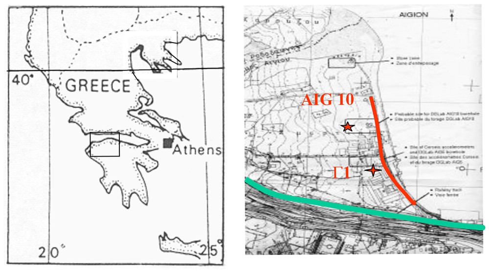
Location map (stars: boreholes Γ1 and AIG 10; red line: 720 m-long seismic profile; green line: topographic trace of Aigion fault).
Carte de localisation (étoiles : forages Γ1 et AIG 10 ; trait rouge : profil sismique long de 720 m ; trait vert : tracé topographique de la faille d'Aigion).
Un profil sismique court apporte des éléments de localisation et de géométrie sur les couches et les failles [14].
2 Log fondamental et évolution géologique
La partie supérieure du forage carotté Γ1 a permis des datations 14C (entre 4,3±0,04 ka BP à 5,8 m et 35,3±0,4 ka BP à 103 m) [10].
Le forage AIG 10 présente la succession suivante (Fig. 2). Les dépôts de la base du forage (496–388 m) sont constitués d'argiles plastiques noires azoı̈ques, renfermant très peu de microfossiles. Cette formation est suivie par l'intercalation de faciès grossiers dans les faciès fins marins (388–330 m). Cet ensemble de transition se poursuit avec le dépôt des conglomérats rigides (330–153 m) présentant des intercalations de faciès fins. Les conglomérats rigides se terminent par des intercalations fines (153–127 m), qui enregistrent de nombreuses intercalations marines. Au-dessus, les intercalations supérieures sont suivies par des dépôts torrentiels conglomératiques d'origine climatique et/ou tectonique. Ces dépôts très grossiers sont présents uniquement dans le compartiment toit, au nord de la faille d'Aigion (127–112 m). La sédimentation devient ensuite lacustre, avec le passage du niveau de la mer sous le seuil de Rion (dépôt de silts à abondants Hydrobia). Cette sédimentation (112–68 m) enregistre encore des intercalations marines liées aux pics des stades marins isotopiques MIS 3a (ca. 37 et 32 ka BP) qui précèdent la période la plus froide, durant laquelle le niveau marin est le plus bas (−125 m). La mer revient vers 11,8 ka BP (−62 m) à la fin du Younger Dryas. Cet événement est souligné par un conglomérat transgressif remaniant les silts sous-jacents. Les dépôts holocènes (68–3,5 m) sont marins littoraux fins (argiles plastiques), alternant avec des ensembles grossiers (sables à conglomérats), interprétés comme des faciès de plage ou des émissaires issus du delta voisin ou de l'escarpement d'Aigion. Les fossiles marins infralittoraux sont très abondants dans les faciès favorables. Les indices d'émersion sont nombreux dans la partie supérieure de l'Holocène (concrétions carbonatées, galets perforés). Le forage se termine de 3,7 à 1,5 m par des faciès continentaux (limons et conglomérats), signe de comblement, recouverts de remblais anthropiques.
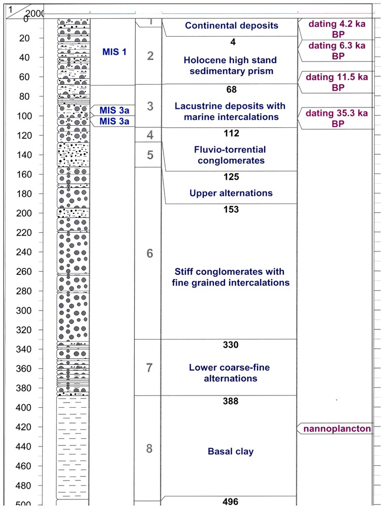
Geological cross section of borehole AIG 10 with available dating.
Coupe géologique du forage AIG 10 avec les éléments de datation disponibles.
3 Taux de sédimentation et taux de subsidence
Les taux de sédimentation ont été déterminés pour l'ensemble des unités à partir des datations et des épaisseurs. Ils permettent d'attribuer un âge aux limites d'unités par extrapolation des données connues (e.g., ca. 50 ka pour le toit des conglomérats rigides).
Les taux de subsidence par période ont été calculés à partir des niveaux de la mer tirés des courbes eustatiques, de la hauteur d'eau donnée par les microorganismes et de la profondeur actuelle en forage. Les variations des taux de subsidence sont interprétées en terme de mouvements verticaux d'origine tectonique. Les taux de subsidence décroissent régulièrement depuis ca. 50 ka.
Les taux de sédimentation sont génériques (faibles dans les sédiments lacustres, moyens à forts dans les conglomérats, très élevés dans le prisme sédimentaire de haut niveau marin holocène). Les taux de sédimentation suivent généralement les variations des taux de subsidence, sauf lors du dépôt de l'ensemble holocène durant lequel la montée rapide du niveau de la mer est responsable des forts taux de sédimentation, qui sont indépendants de la subsidence.
4 Conclusions (interprétation personnelle de Francis Lemeille)
Deux hypothèses ont été utilisées pour attribuer un âge aux dépôts syn-rift. Dans la première (taux de subsidence faibles), les intercalations fines à silto-argileuses sont corrélées avec les pics de haut niveau marin MIS 3 à 11, le repère marin autour de 420 m de profondeur correspondant au stade 11 c et l'ensemble basal des formations syn-rift aux dépôts lacustres de l'ancien lac de Corinthe (< ca 450 ka BP) (Fig. 3). Dans la deuxième hypothèse (taux de sédimentation élevés), les faciès fins sont corrélés aux pics mineurs de haut niveau marin des stades isotopiques 3 et 5, le repère mari autour de 420 m serait le MIS 5e et la formation lacustre l'interstade de bas niveau 6 (Fig. 4).
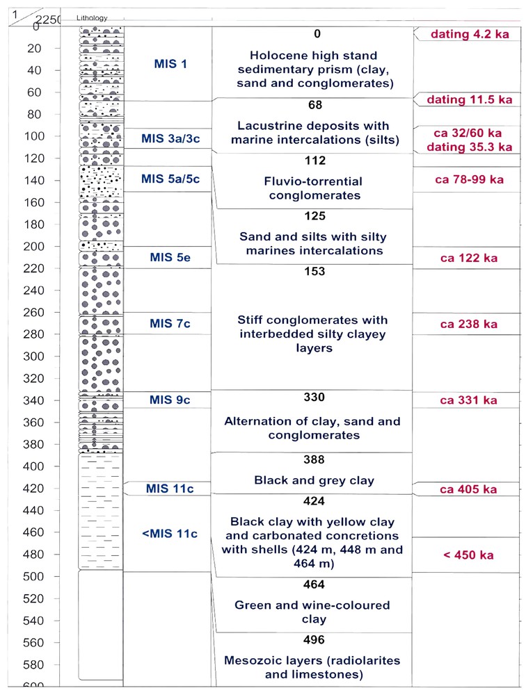
Geological cross section of borehole AIG 10 with interpretation based on slow subsidence rates inferred from the matching of fine-grained sediments with Marine Isotopic Stages 3 to 11.
Coupe géologique du forage AIG 10 avec une interprétation basée sur des taux de subsidence faibles déduits de la corrélation entre les niveaux lithologiques fins et les stades marins isotopiques 3 à 11.
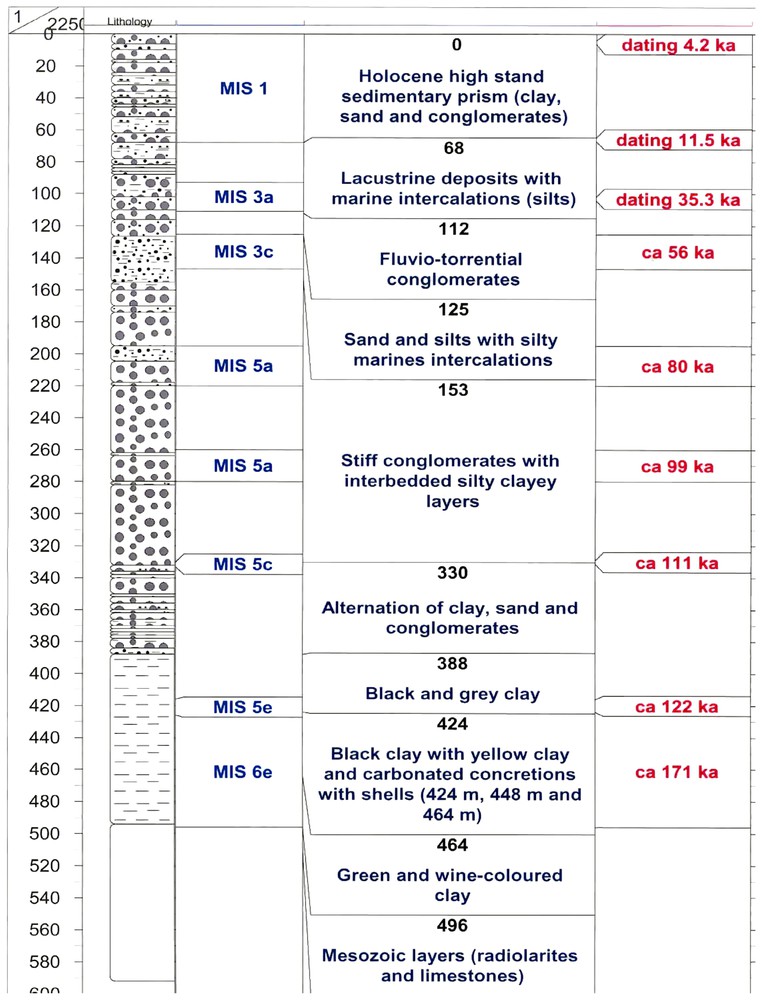
Geological cross section of borehole AIG 10 with interpretation based on fast subsidence rates inferred from the matching of fine-grained sediments with Marine Isotopic Stages 3 to 5.
Coupe géologique du forage AIG 10 avec une interprétation basée sur des taux de subsidence forts, déduits de la corrélation entre les niveaux lithologiques fins et les Stades Marins Isotopiques 3 à 5.
Cette deuxième hypothèse semble la plus pertinente, pour des raisons de paléogéographie, d'évolution géodynamique régionale et de valeur de taux de déformation verticale. Elle impliquerait l'existence d'un contact tectonique entre les formations syn-rift et les formations ante-rift, qui pourrait être souligné par la présence d'oxydations secondaires au voisinage du contact et par la géométrie complexe et multiple de la faille visible dans le profil sismique [14].
Le profil sismique et des corrélations de niveaux datés réalisées avec un forage voisin situé au nord-est montrent un léger basculement des formations vers le sud. Les forages géomécaniques entrepris dans le port montrent des corrélations subhorizontales.
1 Available data
Various studies recently carried out in the Aigion area (Fig. 1) provide data useful for a local synthesis of the Holocene and Upper Pleistocene deposits: (i) short boreholes of the CORSEIS Soft Soil Array (CORSSA) with coring in the Holocene and the Upper-Pleistocene deposits associated with gamma ray logging, located 250 m south of borehole AIG 10; in the deepest borehole (Γ1), samples have been also analysed for environmental features inferred from microfossils [5]; (ii) deep borehole AIG 10 (1001 m): cuttings were sampled each 2 m and complete electric logging performed by GfZ between 0 and 698 m.
Before the drilling of CORSEIS boreholes, a 720 m-long north–south seismic profile was performed by the Patras University and funded by IRSN (‘Institut de radioprotection et de sûreté nucléaire’) for acquiring data on the geometry of the strata, the velocity of sediments and on the location of the main faults [14].
2 Fundamental logging
The borehole AIG 10 is located in the axis of the Meganitis River. Thus the sediments are coarser than those of borehole Γ1, which is located on the edge of the delta. Moreover, no electric logging (except gamma ray) was available in the first 200 m of AIG 10 because of the presence of the casing. Thus, the interpretation of the first 200 m was done with reference to the 205 m-long borehole Γ1.
The most helpful logging tool for interpretation is the gamma ray. Gamma radioactivity correlates with the amount of clay in the sediment. There is no radioactive detritic sand in the area (no feldspars, micas or heavy minerals). Arenaceous components are composed of limestones and radiolarites, which exhibit low radioactivity; so high counting of gamma ray is reliably correlated with clay.
On the basis of dominant lithology, several units have been described. The chronostratigraphic interpretation of the units is inferred from 14C dating of materials from borehole Γ1 between 5.8 m (4.3±0.04 ka BP) and 103 m deep (35.3±0.4 ka BP) [10].
3 Local geological evolution
So far, eight units were recognized from the bottom (496 m below ground level) to the top, in the boreholes G1 and AIG 10 (Fig. 2).
3.1 Unit 8: basal clayey unit (496–388 m)
This unit is mainly composed of plastic clay of more or less silty content. An anoxic environment is inferred from indirect arguments (black clay, absence or scarceness of microfossils, small-sized foraminifera, shells made of gypsum probably after an epigenesis in pyrites followed by an oxidization phase). Ostracods show a brackish environment (e.g., Tyrrhenocythere amnicola, Candona sp., larval Cypridacae) and the rare benthic foraminifera indicate a deep marine environment. Planktonic foraminifera are also present but maybe reworked.
The samples at 420 and 424 m depth provided an association composed of Helicosphaera carteri, Gephyrocapsa oceanica, and Gephyrocapsa aperta. At 420 m, they are accompanied by Coccolithus pelagicus, Syracosphaera pulchra, and Gephyrocapsa ericsonni, confirming the marine environment.
This unit contains fragments of oyster, Cardium, Planorbis, Neritina, and numerous other undetermined shells. The varied environmental evidence (lacustrine, brackish, marine environment) indicates possible reworking of some shelly material.
3.2 Unit 7: lower coarse-fine alternations (388–330 m)
This unit is composed of alternations of coarse and fine material. Clay and silt are still present, but are progressively invaded by sand and gravels. Shells (bivalves and gastropods) are abundant around 380 m toward the base of the unit.
3.3 Unit 6: stiff conglomerates (330–153 m)
This unit comprises intercalations of fine sediments with black clay and silt associated with fine sands. This facies association can also be inferred from ROP (rate of penetration) anomalies in drilling and from gamma ray peak values.
3.4 Unit 5: upper alternations (153–127 m)
This unit is composed of alternating layers and beds of brownish to pink sands and green to red silty clay. Sandy lenses, a few centimetres thick, and their red colour indicate a shallow marine fluvio-deltaic environment away from coarse clastic supply. Six marine intercalations, less than 1 m thick, are inferred from undetermined marine malacofauna and microfossils in fine sediments. This formation represents a very sensitive environment to slight changes in relative sea level.
3.5 Unit 4: fluvio-torrential conglomerates (127–112 m)
This unit was identified in borehole Γ1. This interval corresponds to a homogeneous layer of soft brownish clay with conglomerates. Matrix is composed of unconsolidated brown clay. In borehole AIG 10, the top of this unit is identified by the disappearance of clay at 112 m deep. This unit is probably the source reservoir to the permanent leakage of freshwater in abandoned borehole Γ1.
3.6 Unit 3: lacustrine deposits (112–68 m)
This unit is dominated by green silty clay representing lacustrine deposits with regard to malacofauna (abundant Hydrobia, Neritina, Unios, Limnocardium, pulmonidae gastropods, other debris of unidentified bivalves). Microfossils indicate an oligo- to mesohaline environment on the basis of ostracodes and a lacustrine to lagoonal one with freshwater from benthic foraminifera [5]. The stratigraphic level is below the level of the Rion sill; this would have allowed development of a ‘lake’ (at least a layer of low-density freshwater spread over heavy brackish water), during the glacial lowstand, only fed by the main streams. However, the depth is close to the height of the sill and marine intercalations are still present. Microfossils indicate several marine intercalations (at least four are identified between 92 and 104 m deep) with two main levels at 103 m and 95 m depth, possibly corresponding to MIS 3a. Micropalaeontological analyses of these marine layers indicate a coastal environment, with a depth of ca. 10 m of seawater. The malacofauna is very abundant (corals, various gastropods and bivalves). 14C dating on pieces of shells sampled at 103 m in borehole Γ1 provides an age of 35.3±0.4 ka BP that could be related to lower MIS 3a around 37 ka BP in the sea-level curves [10]. The upper MIS 3a, dated around 32 ka BP in the sea level curves, which is the last marine peak before the main MIS 2 glacial low stand, would then be predicted to be at 95 m depth.
3.7 Unit 2: holocene transgression (68–3.5 m)
This unit starts with a 1 m-thick layer of conglomerates, interrupting and reworking the lacustrine sedimentation and composed of 7 mm-long pebbles of limestones, with a silty cement. Above this, the lithology is dominated by 15 m of black clay with characteristic marine fauna (e.g., Bithium, Dentalium, Serpula, Turritella, Arca, Natica, pieces of corals, oyster, crab claw). Above, the unit is composed of alternations of coarse material (fine to coarse sand, gravels and pebbles) and of black plastic clay. Each sub-unit is about 6–8 m thick. Coarse materials often include perforated pebbles characteristic of sponge-bored pebbles in the beach zone and cements of pink-to-red carbonates. This could be interpreted as a beach with reworked aerial calcrete and beachrock. The coarse material is interpreted as beach deposits developed during each slight variation of sea level (regressive or transgressive) or as reworked detrital material coming from the Meganitis delta or generated by streams coming of the Aigion scarp.
14C dating has been carried out at 5.8 m (4.1±0.04 ka BP), 32 m (6.29±0.04 ka BP) and 66 m (11.5±0.04 ka BP) [10]. After estimation of the mean sedimentation rate, the start of the transgression was extrapolated to ca. 11.8 ka BP. This age corresponds to the end of the cool Younger Dryas period and the inferred sea level elevation (around −62 m) is consistent with the estimated height of the Rion Sill. The age of the transgression is similar to those defined in the Eastern Gulf of Corinth: ca. 12 ka BP [2] and ca. 13 ka BP [11]. In the same way, the top of the marine deposits extrapolates to ca. 3.4 ka BP. Microfossils of the unit are dominated by littoral species [5].
A gas pocket was encountered at 36 m depth, mainly composed of CH4 and CO2, according to analyses performed in borehole Γ1 by the Karlsruhe University (2001) and confirmed by GfZ by in situ spectrometry (2002) in borehole AIG 10. In borehole Γ1, the leakage with high pressure lasted 1 h 30 min. The core shows that the gas is trapped in a 50 cm-thick layer of medium-to-coarse-grained sand without cement and completely encapsulated in clays.
3.8 Unit 1: continental superficial deposits and soil (3.5–0 m)
The upper part of the borehole is composed of 2 m of continental deposits (alluvium and continental conglomerates) with an ochre or beige colour and traces of soil and roots, overlain by 1.5 m of anthropogenic infilling. Below this embankment, the fresh ground water table oscillates according to changes of the weather over the previous few days.
4 Sedimentation rates and subsidence rates
A simple estimation of sedimentation rates is calculated between surfaces for which an age has been inferred. For the selected markers, eustacy curves (e.g., [7–9]) provide sea-level elevation (e.g., [1,6]), and environmental features inferred from microfossils indicate the depth of water [5]. The amplitude of change between extreme depths of seawater is negligible compared to the value of the shifting of sea level between two major peaks. Ideally, these data would allow inference of subsidence rates between any two markers.
Sedimentation rates show high values (mean value 8.6 mm yr−1) for the main transgressive period MIS 1. Low values are seen in lacustrine silts (around 1.5 mm yr−1).
5 Discussion (personal interpretation of Francis Lemeille)
5.1 Geometry of syn-rift deposits
The IRSN seismic profile shows a general backtilting of reflectors with a fan shape increasing in depth basinwards [14]. Borehole Aliki, located 2 km northeast of the AIG 10 site and realized by IPG Paris and ENS Paris, shows that markers are higher than in boreholes AIG 10 and Γ1 confirming the backtilting [10]. Recent boreholes performed by Edaphomichaniki (personal communication, M. Basdekis) and by KEDE in the Aigion Harbour [15] indicate subhorizontal correlations between the main markers parallel to the fault.
5.2 Age of syn-rift deposits
Two assumptions can be proposed for an interpretation of the syn-rift deposits in terms of age. In the first assumption, all the fine-grained to clayey intercalations (intermediate markers) are matching with the short marine high stand MIS 9, 7, 5 and 3 in the general conglomeratic sedimentation (Fig. 3). Deposits would spread between lacustrine deposits of the Corinth Ancient Lake at the bottom (prior to MIC 11c) and Holocene marine transgressive deposits (MIS 1). Earlier marine sediments, beginning at 420 m, would be considered as MIS 11c, i.e., 450 ka BP (with respect of first marine transgression deposits pointed out in the Corinth Gulf). The inferred subsidence rates would be very low (constant values around 1 mm yr−1 since MIS 11c). In the second assumption, all the intermediate markers would match with the minor and major high stands of MIS 5 and MIS 3 (Fig. 4). Deposits would spread between lacustrine deposits related to MIS 6 (i.e., ca 165 ka BP), thus first marine deposits at 420 m would be considered as MIS 5e (ca. 125 ka BP). The above-mentioned nannoplancton association, sampled at 420 and 424 m, appears in literature and is mentioned at different periods (e.g., [12]). Only one period (90–130 ka BP) can be related with a main highstand sea level. Moreover, there is no species typical of the NN 19 zone associated with this microfauna. Inferred subsidence rates would be consistent with uplift rate, close to 1.0–1.4 mm yr−1 in the stepover between the Heliki and Aigion Faults [13]. The subsidence rate is drastically decreasing between MIS 5e (about 4 mm yr−1) and Early Holocene (less than 1 mm yr−1). This drop of the rate is particularly indicated by the start of Holocene transgression, dated around 11.8 ka, corresponding to seawater elevation around 60 m [1,8,9], which is currently at −66 m bsl. The second assumption (fast subsidence rates) is considered as more reliable and relevant. Consequently, in the second assumption, the contact between lacustrine deposits, related to MIS 6, and pre-rift basement in the borehole cannot be a stratigraphic contact with respect to the existence of older deposits in surrounding area (up to MIS 11c and lacustrine below) and to the palaeogeographical shifting trend of faulting activity and depocentres from south to north [4]. Moreover, the value of the markers offset in the basement (200 m) [12] is not consistent with the values of the offsets between deposits in the borehole (hangingwall), whatever the above-mentioned assumptions, and the shorelines exposed in the footwall [3]. The presence of a fault at the contact could be indicated by several oxidization evidence in the black clay, which could be caused by circulation of fluids in cracks nearby the fault plane in the impervious clay, as there is no sedimentological indication of pervious beds in cuttings and in electric logging. All these arguments imply that the Aigion Fault is not a single item and that the contact between syn-rift and pre-rift sediments is probably another Aigion Fault [14]. In the on-going processing of the seismic profile, a two-steps fault is inferred from the interpretation. A future seismic profile is planned to determine the precise geometry of the Aigion Fault.
Acknowledgements
This work was performed in the framework of the ‘Corinth Rift Laboratory’ and of the European Programs DGLab (EVR1-CT-2000–40005), 3F (ENK6–2000–00056) and CORSEIS (EVG1-CT99–00002). IRSN participated to the funding. We are grateful to R.E.L. Collier and V. Lykousis for their reviews, which allowed us to improve the paper.