

Version française abrégée
Dans le cadre des projets de l'UE 3F-Corinth et Corseis, faisant partie du « Corinth Rift Laboratory », trois campagnes géochimiques en eaux souterraines ont été menées en octobre 2000, septembre 2001 et juillet 2002 dans la zone orientée NW–SE comprise entre Selianitika (NW) et Trapeza (SE), à travers les secteurs d'Aigion, Temeni, Eliki et Diakofto. Les principaux objectifs de cette étude étaient : (i) la compréhension du comportement géochimique des eaux souterraines circulantes ; (ii) la détermination de l'influence des systèmes de failles actives sur la géochimie et l'hydrologie des eaux souterraines, l'exploitation de techniques géochimiques testées dans d'autres régions ; (iii) la sélection de sites appropriés pour l'installation de prototypes de stations géochimiques GMS II destinées à la surveillance géochimique de l'activité tectonique de la région.
Nous avons échantillonné 50 sites (42 puits et 8 sources). Nous avons fait des analyses géochimiques complètes sur tous les échantillons, et aussi l'analyse des isotopes stables (C, H et O) sur une sélection de 19 d'entre eux.
Nous avons identifié trois zones de failles avec des anomalies géochimiques : (i) la région d'Eliki–Nikolaikea, qui se situe à l'intersection de deux segments en échelon de la faille d'Eliki ; (ii) à proximité des bordures nord–ouest et sud–est de la zone d'investigation, qui s'appelle la zone de Selianitika–Rododafni–Nerazes ; (iii) le secteur de Trapeza. Dans les deux derniers secteurs, un aquifère Na–HCO3 artésien jaillit, caractérisé par (1) une teneur anormale en CO2, F, NH4 et en éléments traces et (2) par une composition isotopique en C, H et O complètement différente. De plus, ces données isotopiques suggèrent que les eaux échantillonnées ont une origine météorique, excluant toute origine volcanique, juvénile ou magmatique.
En ce qui concerne les gaz dissous dans les eaux souterraines, nous pouvons dire que cette région n'est pas particulièrement affectée par un dégazage profond de la croûte/manteau, comme l'on aurait pu s'y attendre, en raison de la présence de failles actives/sismogéniques régionales. Nous considérons cette géochimie des fluides comme source de données de base pré-requises pour comprendre les éventuelles variations futures enregistrées dans le cadre de mesures géochimiques discrètes ou en continu.
En considérant l'ensemble de ces données, le puits de Nerazes et les thermes de Selianitika ont été sélectionnés en vue de l'exploitation d'une surveillance géochimique et hydrologique multivariables continue de l'activité tectonique.
1 Introduction
In the frame of the EU projects 3F-Corinth and CORSEIS, being part of the ‘Corinth Rift Laboratory’, in October 2000, September 2001 and July 2002 three geochemical surveys in ground waters were carried out in a NW–SE trending belt from Selianitika (NW) to Trapeza (SE), throughout the sectors of Aigion, Temeni, Eliki and Diakofto (see Fig. 1, also showing the map of the total CO2 content in ground waters). The main purposes of this study were:
- (i) to define the geochemical patterns of the circulating ground waters;
- (ii) to discriminate the role of active fault systems in affecting the ground water chemistry and hydrogeology, exploiting geochemical techniques already tested in other areas [2,3,6,9–12];
- (iii) to select optimum sites in order to install the GMS II geochemical station [10] for continuous geochemical surveillance of the tectonic activity of the area.
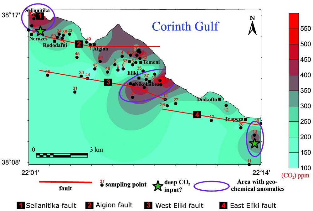
Geographical distribution of the sampled sites (springs and wells). Main faults and distribution of the total CO2 content in ground waters are also reported.
Distribution géographique des sites échantillonnés (sources et puits). Les failles principales et la distribution du CO2 total contenu dans les eaux souterraines sont aussi représentées.
A total of 41 wells and 9 springs have been sampled. In addition, chemical analyses of AG-10 deep-well groundwater samples, collected at different depths during July 2002, have been performed; these data are presented and discussed by Giurgea et al. (this issue).
2 Fluid geochemistry survey: results and discussion
2.1 Methodology
In the field, physicochemical parameters such as temperature, pH, Eh, electrical conductivity, alkalinity (by titration with HCl 0.05 N), H2S and NH4 (by colorimetric methods) and total dissolved CO2 content (with an ORION ion-selective electrode) have been determined. All samples have been analysed for 222Rn by the ACC-γ-spectrometry method [6]. Water samples were filtered through cellulose filters (0.45 μm) and acidified (for cations analysis) with HCl 6 M. In laboratory, major and some minor constituents have been determined on all samples by DIONEX ion chromatography. On 17 selected samples, analyses of minor and trace elements (Li, B, Si, Fe, Mn, As, Br, Sr, Sb, Hg, U) have been performed by an ICP-mass spectrometry (ELAN 6100). On 19 samples, δ13C(TDIC), δ18O and δD of waters have been measured. 13C/12C analysis followed certified methods [7] and are expressed as δ13C% vs PDB standard. D/H isotopic analyses were performed using the Kendall and Coplen technique [4]. 18O/16O analyses were carried out by the CO2–water equilibration technique [1]. Results are reported in δD and δ18O% vs V-SMOW standards.
2.2 Groundwater chemistry
The chemical composition of the 50 water samples is presented in terms of relative Ca, Mg and Na+K concentrations (Fig. 2a) and relative Cl, SO4 and HCO3 contents (Fig. 2b). Inspecting these triangular plots, the types of water may be classified as follows:
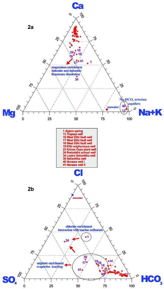
(a) Triangular plot CaMgNa+K; (b) triangular plot Cl–SO4–HCO3.
(a) Représentation triangulaire CaMgNa+K ; (b) représentation triangulaire Cl–SO4–HCO3.
2.2.1 CaHCO3 waters
They represent the bulk of our samples, and their chemistry indicates a very fast and shallow interaction with conglomerates and limestones cropping out in the studied area. The waters are cold ( °C), neutral or slightly alkaline, not mineralised (Total Dissolved Solids-TDS, <0.7 g l−1), and show positive Eh values (typical of shallow oxidising fluids, with no H2S content). The main geochemical characteristics indicate shallow hydrologic circuits along the regional tectonic structures.
2.2.2 Ca (NaMg)HCO3 (ClSO4) waters
These waters are slightly enriched in chlorine, sulphate, sodium and magnesium and are regarded as geochemically evolved calcium-bicarbonate waters. Their temperatures are >18 °C (up to 21 °C, Loutra Selianitika spa, sample 34) and the salinities (TDS>1 g l−1) were the highest found in the investigated area. Redox potential values (Eh) are lower, even though still positive, for samples located in the Eliki area and for the artesian wells of the Nerazes and Trapeza areas. The only clear occurrence of H2S (Eh=−150 mV) was found at site 34. Very likely the H2S (up to 0.5 ppm) has an organic origin, being produced by the reduction of SO4 due to bacterial activity in anaerobic environment. In the 70 m-deep well feeding the thermal bath, a continuous monitoring station was installed in September 2001, which is, presently, on line.
Two different water–rock interaction processes are emphasised to account for their sulphate and magnesium enrichment:
- (i) interaction with marine sediments (containing NaCl-rich pore fluids relatively concentrated in SO4 and Mg) and/or with a brackish sequence of silty sands, marls, clays and diatomitic shales, observed in the Aigion spring and Rododafni School well area [5,8] (samples 1 and 24, respectively;
- (ii) dissolution of dolomite and dolomitic limestones (with the presence of evaporitic strata) for samples 16, 17, 18 (located on the West Eliki fault), sample 19 (located in the plain between the village of Nikolaikea and the coast), as well as for samples 34, 39 and 41 (located in the Selianitika–Nerazes area).
2.2.3 NaHCO3 waters
This peculiar chemistry pertains only to samples 13 and 40, located in the village of Nerazes and close to the town of Trapeza, respectively. They are the most pronounced artesian wells in the area, representing the existence of deeper CO2-rich aquifers interacting with clayey strata. The salinity of these waters (TDS >1 g l−1), together with their relatively high and even temperatures (about 20–21 °C all the year round) testify both, deep hydrological circuits and longer lasting water–rock interaction processes with respect to the other shallow aquifers discharging throughout the entire area. The Nerazes well is an optimum site to monitor continuously the relationships between seismic events and hydrodynamic as well as geochemical variations. Because of the promising hydrological characteristics and the easy logistics, a geochemical continuous monitoring station (GMS II) [10] was installed at the Nerazes well in September 2001.
2.3 Stable isotope compositions
In the diagram δ18O–δD (Fig. 3) all the waters investigated in the study area plot close to the worldwide meteoric water line, indicating their meteoric origin. The observed small differences in the isotopic composition are mainly due to climatic effects, controlling the final isotopic composition of rain and ground waters. Magmatic, juvenile, volcanic and other particular origins that can lead to anomalous isotopic fluid compositions can be excluded.
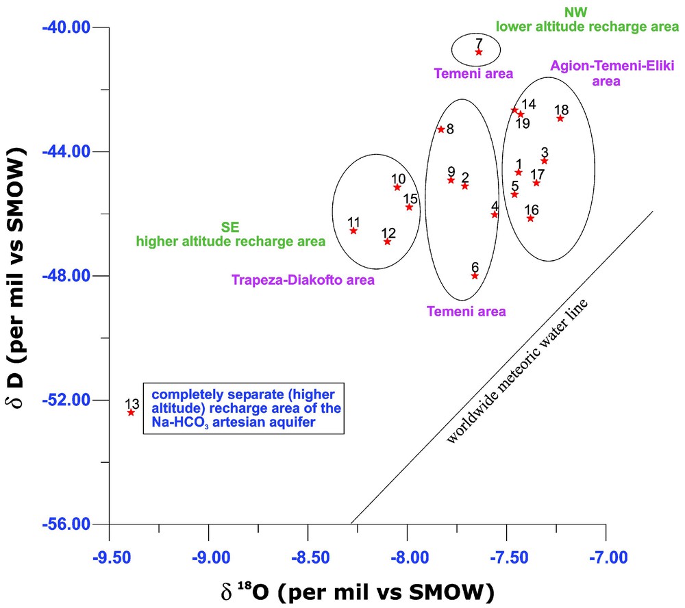
δ18O vs δD diagram, showing the isotopic composition of water samples in the study area. The worldwide meteoric water line is also shown.
Diagramme δ18O en fonction de δD, montrant la composition isotopique des échantillons d'eau dans la région d'étude. La ligne de l'eau météorique mondiale est aussi représentée.
Any enrichment in 18O in the investigated fluids, with respect to the meteoric water line, was detected. A shift toward less negative δ18O values is generally observed for thermal ground waters, indicating isotopic exchange between hot fluids and carbonates. The lack of any thermal signature in the discharging waters fully supports the outlined features. A trend of increasing δ18O and δD from southeast to northwest is observed (‘heaviest’ waters towards the southeast, ‘lightest’ waters towards the northwest). This observation reflects different altitudes of the recharge areas for each group of shallow aquifers. The Trapeza artesian well (sample 13) is characterised by an unusually light isotopic composition, suggesting a higher altitude of the recharge area with respect to the other analysed waters. This area is far from the well about 5–10 km southward. Therefore, the artesian circulation is necessarily longer with respect to the other shallow aquifers, having a local recharge. This interpretation, based on isotopic data, fits very well with other characteristics of the Trapeza water, such as the peculiar Na–HCO3 chemistry and the salinity, one of the highest measured in the investigated area.
2.4 Dissolved gases
222Rn content in the sampled ground waters is quite low, ranging between 1 and 10 Bq l−1. The values reflect:
- (i) the interaction of the circulating waters with the carbonatic lithologies cropping out in the investigated area, notoriously depleted in uranium (precursor of 222Rn)-bearing minerals;
- (ii) the lack of convection of fluids from great depth, being the 222Rn a typical pathfinder of this peculiar fluid-transport process [11,12];
- (iii) the lack of an uprising gaseous components acting as carrier for radon, like deep CO2 [9].
The map of the dissolved CO2 distribution (Fig. 1) shows four areas characterised by high contents (>350 ppm) compared to a low general background level: Selianitika–Nerazes–Rododafni, Aigion–Temeni, southeastern sector of the Eliki Fault–Nikolaikea and Trapeza. For all investigated waters, carbon isotope values () indicate an atmospheric and/or a biogenic origin of carbon dioxide. Any deep origin (mantle and/or thermal decomposition of the carbonates) can be inferred. Only for the Trapeza artesian aquifer the measured carbon isotope value (δ13C=−5.26) indicates a partial equilibrium with the marine carbonates.
3 Conclusions
Despite the investigated area is crossed by very active and seismogenetic fault segments (Eliki and Aigion ones), elsewhere normally associated with upraise of deep fluids [2,3,6,9–12], our fluid geochemistry study did not show characteristics of deep circulation fluids. Low salinity, low temperature, neutral-alkaline pH, positive Eh, low 222Rn, low concentration of deep seated fluid tracers such as Li, B, SiO2, As, Hg, etc.) as well as O, H, C isotopic ratios denote slight water–rock interaction processes and the lack of convection of fluids from great depth. However, deep fluid signatures may be masked by a mixing of huge amounts of meteoric waters. Moreover, the O and D isotope data suggest that sampled waters are predominantly of meteoric origin.
Some weak hints such as low Eh values, high CO2 and slightly enriched H2S, SO4, NH4, B contents indicate the presence of ‘Geochemically Active Fault Zones’ (GAFZ definition [12]) mainly (i) within the Eliki–Nikolaikea area, which is located at the intersection-en-echelon sector between the two Eliki fault segments and (ii) in proximity to the northwestern and southeastern edges of the investigated area, namely the Selianitika–Rododafni–Nerazes and the Trapeza sectors. In these last areas, an artesian Na–HCO3 aquifer is up-welling, characterised by anomalous contents of CO2, F, NH4 and other trace elements and by completely different C, O, H isotopic signatures.
The studied area is affected mainly by two groundwater circuits:
- (i) deep artesian and alkaline aquifers discharging mainly in the Nerazes and Trapeza sectors;
- (ii) a fast and shallow circulation in conglomerate and carbonates characterised by Ca–HCO3 waters, locally interacting with deeper dolomitic strata (containing evaporitic lenses) along the Eliki fault and in the Nerazes–Selianitika sector and with marine sediments in the Rododafni and Aigion areas. These processes caused enrichments in SO4, Cl, and Mg as well as B, Br, Li, and Sr.
Regarding amount and nature of the dissolved gases in ground waters, we may assess that the area is not particularly affected by crustal/mantle degassing, which is normally expected as a consequence of the presence of regional active/seismogenic faults.
However, we assessed the regional fluid geochemistry background as pre-requisite to understand possible future variations to be investigated by discrete or continuous geochemical monitoring.
Considering the gathered data as a whole, the Nerazes well site and the Selianitika spa have been selected for exploiting a multivariable geochemical-hydrological continuous monitoring surveillance of the tectonic activity. The choice to perform continuous geochemical observations is strongly encouraged considering the geologic and tectonic framework in which these sites are situated.