

Version française abrégée
La région d'Aegion, localisée dans la partie occidentale du golfe de Corinthe, est l'une des régions les plus actives de Grèce du point de vue sismotectonique, avec des failles normales dominantes de direction est–ouest. La région est caractérisée par une activité sismique continue, responsable de séismes importants et destructeurs, comme le séisme d'Aegion de 1995 (M=6,2), qui a causé la mort de 26 personnes et de sérieux dégâts aux habitations (environ 2000 constructions ont souffert de dégâts majeurs et ont dû être reconstruites). En raison de cette forte sismicité, la région a été choisie pour y installer un réseau d'accéléromètres et de capteurs de pression interstitielle en sols meubles dans le but d'étudier les effets des conditions géologiques locales sur le mouvement du sol et, de manière plus précise, la réponse linéaire et non linéaire du sol, ainsi que les phénomènes de liquéfaction.
Ce réseau est désigné ensuite sous l'acronyme CORSSA (Corinth Soft Soil Array). Son installation a fait l'objet d'une collaboration entre plusieurs organismes (AUTH, NKUA, IRSN, IPGP et ENS-Paris) dans le cadre du programme européen CORSEIS [1,2]. Il est installé dans le compartiment nord (« toit ») de la faille d'Aegion, la principale structure tectonique qui traverse la ville d'Aegion formant un escarpement majeur proche du littoral. Le secteur où a été installé le réseau est pratiquement sur le rivage, où les sédiments très meubles (NSPT<8), constitués de sables silteux dominent les couches de surface, et où des phénomènes de liquéfaction ont été relevés lors du séisme de 1995. Le réseau CORSSA est composé de quatre accéléromètres large bande à trois composantes, un accéléromètre en surface et deux capteurs de pression interstitielle. L'accéléromètre de référence, installé dans une couche de conglomérats rigides à −178 m peut être considéré comme la référence au rocher. Les trois autres accéléromètres sont installés dans les dépôts marins fluvio-deltaı̈ques saturés (ML, CL, SC) à diverses profondeurs (−14, −30 et −60 m). Les capteurs dynamiques de pression interstitielle sont installés dans les dépôts saturés marins non consolidés (SM, ML-CL), couches susceptibles de liquéfaction, à des profondeurs égales ou proportionnelles à celle des capteurs accélérométriques (−6 et −14 m) dédiés à l'étude des phénomènes de liquéfaction. L'ensemble du réseau accélérométrique est associé à un système central d'enregistrement 18 canaux, installé dans un petit abri hébergeant l'infrastructure nécessaire pour la collecte des données et la transmission (ligne téléphonique ISDN, alimentation électrique, appareil GPS). Depuis son installation, plusieurs événements sismiques locaux et régionaux ont été enregistrés et analysés.
D'importantes études géologiques, géophysiques (cross-hole, down-hole, sismique réflexion) ainsi que des études géotechniques (mesures in situ et en laboratoire, incluant des tests dynamiques et des essais à la colonne résonnante), ont été entreprises sur ce site, dans le but de définir la structure géologique et les paramètres dynamiques du sol (Vs,G0, courbes G−γ−D %) des différentes couches de terrain. La réponse sismique du sol a été étudiée de manière théorique, dans le but d'identifier différentes caractéristiques d'amplification pour une propagation d'onde sismique 1D SH du rocher à la surface. Divers modèles élastiques linéaires et linéaire-équivalents ont été utilisés, avec divers signaux incidents réalistes (enregistrements d'événements sismiques locaux ou régionaux) et théoriques (ondelettes de Ricker de fréquence variable), calés à différents niveaux d'accélération. Ils indiquent qu'en raison du voisinage du système de la faille d'Aegion, l'analyse 1D SH ne peut décrire avec précision le phénomène complexe de dispersion de l'onde généré par les discontinuités géologiques et topographiques dans la zone d'étude. La modélisation 2D semble plus adaptée pour l'analyse théorique. Seules les modélisations 1D en ondes SH ont été abordées.
À partir de maintenant et dans un avenir proche, CORSSA fournira un jeu d'enregistrements de haute qualité bien documentés des séismes locaux et régionaux, qui enrichiront les bases de données de mouvements forts européennes et mondiales. Leur analyse et leur dissémination seront très utiles autant pour les pays à forte sismicité, comme la Grèce, que pour les régions à faible sismicité avec des taux de déformation modérés, comme la France.
1 Introduction
Site effects may produce large ground-motion amplification during an earthquake. The geometry of the subsoil structure, the soil types and the variation of their properties with depth, the lateral discontinuities and the surface topography modify significantly the strong ground motion and are correlated to damage pattern during a large earthquake. Based on this statement, CORSSA (CORinth Soft Soil Array) has been developed in the highly seismic area of Aegion, which was shaken by the 1995 Aegion earthquake (Ms=6.2), which caused 26 deaths and extensive damage to buildings. The aim is to develop an adequate down-hole array of 3D accelerometers and pore pressure transducers. The deepest sensor reached a stiff geological formation that consists of conglomerate and is considered as a ‘seismic bedrock’ in the well-known geological and geotechnical environment where the dynamic soil properties are well defined through field and laboratory tests. CORSSA is established by the Aristotle University of Thessalonica, the National Kapodistrian University of Athens, the ‘Institut de physique du Globe’, Paris, and the ‘Institut de radioprotection et de sûreté nucléaire’ in the framework of the European Program CORSEIS [1,2].
2 Location
The Aegion city is located in the Gulf of Corinth, one of the most active seismotectonic areas in Europe (Fig. 1), with important north dipping WNW-trending active normal faulting. One of these faults is the Aegion Fault, with an average slope of 40° and an escarpment greater than 40–100 m high (Fig. 2). CORSSA has been established at the shoreline of Aegion. The selection of the site accomplishes two basic requirements:
- (a) loose-soft soil materials susceptible to liquefaction and/or significant non-linearity at shallow depths; and
- (b) relatively shallow seismic bedrock for the installation of the deepest accelerometric station.

Investigated area; Aegion city and the Gulf of Corinth.
Zone d'étude, ville d'Aegion et golfe de Corinthe.
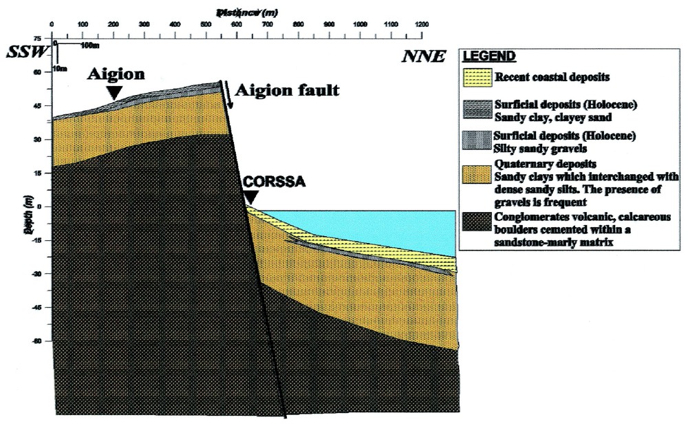
Simplified north–south cross-section.
Coupe simplifiée nord–sud.
3 Technical description of CORSSA
CORSSA consists of four broadband 3D down-hole accelerometers, one surface accelerometer and two pore-pressure transducers (Fig. 3). The deepest accelerometer (used as reference station) installed within a geological formation consisting of conglomerate at a depth of −178 m, the other three are located within saturated fluvio-deltaic, marine deposits ML, CL, SC at depths of −14, −30 and −60 m, while the dynamic pore pressure probes installed at −6 and −14 m depth within saturated loose marine deposits SM and ML. These soil layers are susceptible to liquefaction; the depths of the installation of the pore pressure probes are intermediate between the accelerometers, in order to correlate their results. The accelerometers are connected with an 18-channel main recorder and the pore-pressure transducers with a 2-channel data logger. Both have common time recording.
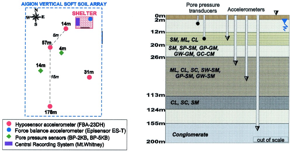
General layout of the CORSSA test-site.
Disposition générale du site test de CORSSA.
4 Geological, geotechnical and geophysical characterization of the CORSSA soft-soil formations
Extensive geological, geophysical and geotechnical surveys have been performed in the site of CORSSA. Geological survey includes detailed geological mapping of the greater area of interest. The geotechnical campaign included six geotechnical boreholes (of depths: 6 m, 2 ×14, 31, 60 and 178 m), in situ (NSPT and water table measurements) and laboratory tests on intact and disturbed soil samples. Special emphasis was given to the resonant column dynamic tests (Table 1). The geophysical campaign involved borehole (cross-hole, down-hole) as well as surface surveys (seismic reflection). These measurements have been performed in order to define the geological structure and the dynamic soil properties (P- and S-wave velocities, Vp and Vs, shear modulus, G0 at low strains, shear modulus degradation curves and material damping vs. shear strains, %)), of the different geological formations.
Physical, mechanical and dynamic properties of soils tested on a resonant-column apparatus
Propriétés physiques, mécaniques et dynamiques des sols testés à l'aide de l'appareil à colonne de résonance
| Test | Bore | Depth | σ′v | Speci- | w | WL | PI | CF | γ | γ d | e | G s | Organics | Calcareous | Cu | OCR | γ [%] | G max | V s | D min | USCS | Soil description |
| number | hole | h [m] | [kPa] | men | [%] | [%] | [%] | [%] | [kN m−3] | [kN m−3] | [%] | matter∗∗ | [kPa] | [MPa] | [m s−1] | [%] | ||||||
| (<2 μm) | [%] | |||||||||||||||||||||
| COR-1/RC | Γ3 | 13.6–14.2 | 130.2 | UN1 | 24.6 | 26.9 | 10.0 | 22 | 19.21 | 15.42 | 0.734 | 2.726 | 1.1+ | 21.9 | 4 | 0.0007 | 60.5 | 174.3 | 1.85 | CL | Dark grey to black organic silty clay with sand | |
| 13.0++ | ||||||||||||||||||||||
| COR-2/RC | Γ2 | 34.2–34.8 | 334.4 | UN1 | 24.6 | 31.3 | 11.9 | 23 | 19.46 | 15.62 | 0.714 | 2.729 | 1.8+ | 20.8 | 1 | 0.0002 | 84.1 | 203.0 | 1.88 | CL | Dark grey organic silty clay | |
| 13.5++ | ||||||||||||||||||||||
| COR-3/RC | Γ2 | 47.0–47.6 | 461.3 | UN1 | 25.8 | 28.5 | 10.2 | 22 | 19.41 | 15.43 | 0.707 | 2.685 | 0.8+ | 23.2 | 80.2 | 0.0002 | 111.4 | 233.2 | 2.00 | CL | Dark grey organic silty clay | |
| 14.5++ | ||||||||||||||||||||||
| COR-4/RC | Γ1 | 14.0–14.6 | 134.0 | UN1 | 27.1 | – | NP | 1 | 19.52 | 15.37 | 0.704 | 2.669 | 0.5+ | 21.6 | 4.3 | 0.0004 | 64.9 | 180.1 | 1.48 | SM | Dark grey to black organic silty sand | |
| 12.4++ | ||||||||||||||||||||||
| COR-5/RC | Γ1 | 66.0–66.6 | 646.6 | UN1 | 28.5 | 41.2 | 19.3 | 36 | 19.37 | 15.07 | 0.752 | 2.690 | 21.3 | 1 | 0.0001 | 120 | 240 | 2.50 | CL | Light grey organic silty clay with abundant shells | ||
| COR-6/RC2 | ∗ | ∗ | R1 | – | NP | – | – | 15.76 | 0.669 | 2.630 | SP | Grey clean sand | ||||||||||
| 13.55 | 0.970 | |||||||||||||||||||||
| COR-7/RC2 | ∗ | ∗ | R1 | – | NP | – | – | 16.01 | 0.643 | – | SP | Grey clean sand with 10% gravels | ||||||||||
| 13.91 | 0.891 | |||||||||||||||||||||
| COR-8/RC2 | ∗ | ∗ | R1 | – | NP | – | – | 16.97 | 0.550 | – | SP | Grey clean sand with 20% gravels | ||||||||||
| 14.64 | 0.797 |
∗ River sand came from Redina region.
1 UN, undisturbed specimen; R, remoulded specimen.
2 For COR-6/RC, COR-7/RC & COR-8/RC γdmax,γdmin,emin & emax.
+ Determined using the H2O2 method.
++ Determined using the ignition method.
∗∗ Determined using HCl method.
The geological structure is described by three lithostratigraphical units: the lower one consists of very stiff clays, marls and very dense sands directly overlying the alpine substratum, which consists of Mesozoic limestones. The middle comprises typical deltaic and alluvial fan deposits mostly conglomerates and sands, overlying the previous unit. The topmost unit is characterized by alluvial fan deposits, upon which the Aegion city is located. Holocene and recent deltaic and fluvial deposits cover all the rest. Recent geological interpretation indicates the following cross section:
- (1) in the footwall: 18–27 m of alternation of silt and coarse sand (low Vs) above stiff conglomerates (high Vs);
- (2) in the hanging wall, same formations covered by loose conglomerates, silty lacustrine deposits and Holocene deposits with low velocity [4].
The proposed geotechnical profile of CORSSA is given in Fig. 4, while Fig. 5 illustrates the dynamic soil properties for all soil formations, estimated from resonant column tests.


Representative 1D soil profile for the CORSSA site.
Profil de sol 1D représentatif pour le site CORSSA.
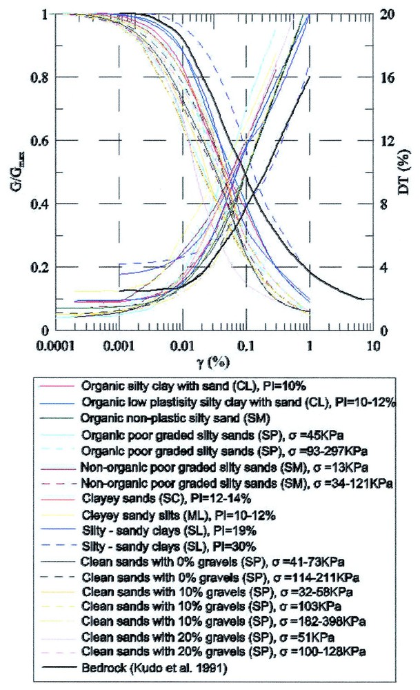
Dynamic soil properties for all soil formations at CORSSA site.
Propriétés de dynamique de sol pour toutes les formations pédologiques du site de CORSSA.
5 Recordings
Since the full operation of the CORSSA array (March 2002), some local as well as regional events have been recorded (M⩽4.5, R⩽200 km). An example is presented in Fig. 6, which illustrates the three components of a small event (Ms=3.5) recorded on 20 May 2002. A specific database is under construction, comprising all recordings with the description of the seismological parameters. The event presented herein is too small (PGA=0.042 g) to account for non-linear phenomena. Nevertheless, it is quite interesting to calibrate in the linear elastic range the numerical tools to be used and to study the physics of the ground motion in the vicinity of faults and topographic relief.

The three components of a small event (Ms=3.5) as recorded on the central recording system of CORSSA. Time histories and their acceleration response spectra at the surface for their horizontal components.
Les trois composantes d'un petit événement (Ms=3.5) reporté dans le système d'enregistrement central de CORSSA. Histoires dans le temps et leurs spectres de réponse d'accélération à la surface pour leurs trois composantes horizontales.
6 Ground response analyses
Preliminary 1D SH site response analyses have been conducted in CORSSA site using as input soil model the well constrained 1D profile of the site. Different input motions were used (Ricker wavelets of different central period, the deconvoluted recordings of the 1995 Aegion earthquake, as well as other recordings at outcrop conditions) scaled at different PGA values ranging from 0.1 g to 0.5 g. The input motion is introduced at the outcrop. The bedrock is considered at −178 m and maybe rigid or elastic. No major difference is found for the two assumptions. The analysis is basically equivalent linear using the software CyberQuake [3]. The resulted absolute and normalized response spectra of these motions have been compared with the corresponding elastic spectrum proposed by the National Greek Aseismic Code (Fig. 7(a) and (b)), for the soil category C (D according to EC8). The scope of these preliminary analyses is not to compare them with actual recordings, but rather to check the 1D model and identify the threshold between linear-elastic and non-linear phenomena. As it is illustrated in Fig. 8, the non-linear behaviour of soils is expected from rather low intensities (∼>0.15 g), while strong de-amplification is observed at high shaking levels independently of the input motion characteristics. Recorded ground motions are very small to identify experimentally non-linear phenomena due to soil properties. However, in the small strain range of these recordings, we have observed quite important amplifications of both horizontal (Fig. 8) and vertical components (Fig. 6).

Comparison between absolute (A) and normalized (B) acceleration response spectra of (a) Ricker wavelets, (b) deconvoluted longitudinal component of the main Aegion earthquake, (c) deconvoluted transversal component of the main Aegion earthquake scaled to PGA=0.1±0.5 g and the Hellenic Aseismic Code (EAK2000) for soil category C (damping used=5%).
Comparaison entre spectres de réponse d'accélération absolus (A) et normalisés (B) : (a) ondelettes de Ricker, (b) composante longitudinale déconvoluée du principal tremblement de terre d'Aegion, calé à l'échelle de PGA=0,1, (c) composante transversale déconvoluée du principal tremblement de terre d'Aegion à l'échelle PGA=0,1±0,5 g et selon le code grec d'asismicité (EAK 2000) pour la catégorie C du sol (amortissement de 5%).
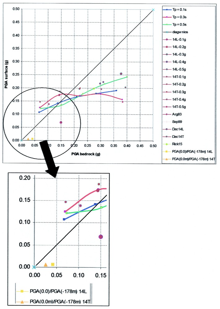
Computed PGA at the surface of the CORSSA array versus the input ground motion at −178.0 m. The amplification of the horizontal components of the recorded motion is given in an enlarged scale.
PGA calculé à la surface de la flèche de CORSSA en fonction du mouvement de terrain d'entrée à −178,0 m. L'amplification des composantes horizontales du mouvement enregistré est donnée selon une échelle agrandie.
7 Liquefaction susceptibility and risk
Preliminary analyses of the liquefaction susceptibility and risk indicate that the liquefaction susceptibility is very important in the loose saturated silty sand layers found at depths 4±6 m and 12±20 m (NSPT=5±6, D60/D10∼4, PI<5). The risk of liquefaction is high for acceleration values greater than 0.20 g at outcrop conditions.
8 Conclusive remarks
CORSSA is a well-established experimental facility in Europe. With all other experiments and facilities deployed in the Corinth Gulf, it is expected to generate a set of high-quality and well-documented data (geological, geotechnical, etc.) and recordings from local and regional earthquakes that will enrich the European and World databases of strong recordings. The choice of the site is particularly successful combining high seismicity, favourable soil conditions to study the effects of non-linear and liquefaction phenomena and geological-tectonic and topographic features on ground motion. The release of the data and the accompanying studies will be very useful both for countries with high seismicity, like Greece, and low-deformation-rate areas with weak seismicity, like France.