

Version française abrégée
À la suite du travail effectué sur la côte sud du golfe de Corinthe dans le cadre du projet DG-Lab, nous présentons ici de nouvelles données de terrain, qui montrent que la localisation des bassins sédimentaires Plio–Pléistocène a été contrôlée par les structures préexistantes de la chaı̂ne Hellénique. La nouvelle carte géologique (Fig. 1) démontre que le remplissage syn-tectonique sur la côte sud est réparti en quatre séquences de dépôt (numérotées de 1 à 4), séparées par des discordances. Sur la Fig. 1, les codes lithologiques sont fl : conglomérats alluviaux et deltaı̈ques ; L : sables, silts, marnes et argiles lacustres à lagunaires, interstratifiés avec des conglomérats ; G : Gilbert deltas ; t : terrasses marines et continentales, a : dépôts alluviaux récents. La distribution, les faciès et l'épaisseur des sédiments sont notablement différents dans les sous-bassins d'Aigion et de Derveni, respectivement situés à l'ouest et à l'est de la vallée du Kratis. En particulier, on notera que : (1) le remplissage du sous-bassin de Aigion et la puissante série des Gilbert-deltas G2 et G3 ont été contrôlés par l'activité persistante de la faille de Pirgaki—Mamousia ; (2) la série du sous-bassin de Derveni débute par des argiles et des marnes (L3) qui recouvrent le delta G2 de la région de Akrata. Les variations latérales de facies et les indicateurs de paléo-courants dans la séquence L3 démontrent une fermeture du bassin de Derveni contre la crête de carbonates de Kratis. Au-dessus, d'épais Gilbert-deltas (G4) s'interdigitent avec des turbidites marines. La propagation vers le nord de la sédimentation peut être associée à la migration des failles bordières.
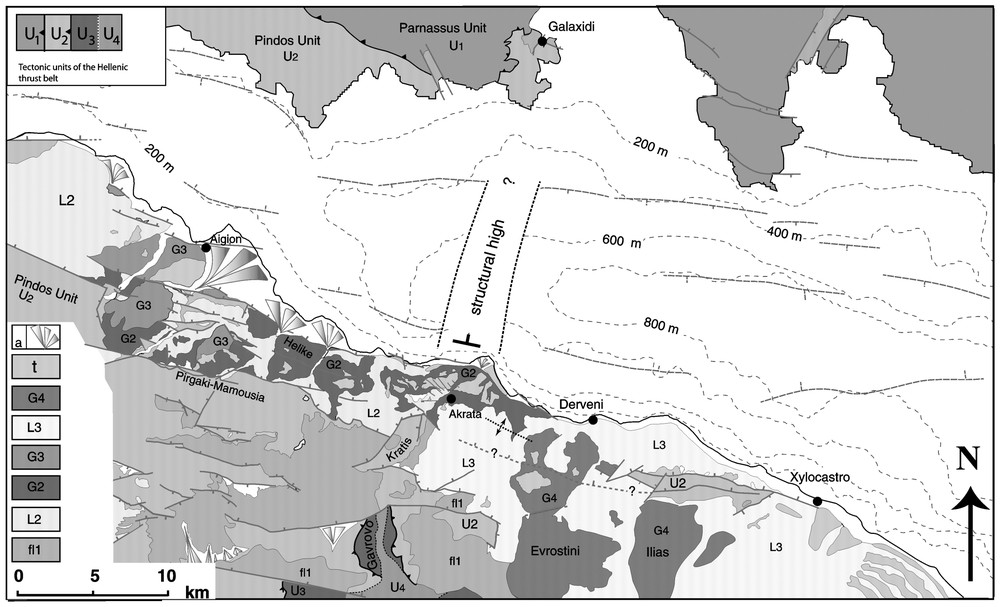
(a) Geologic map of the south shore of the Gulf of Corinth. The Plio–Pleistocene sedimentary sequence above the Hellenic thrust sheets (U1 to U4 from top to bottom) is subdivided in four depositional sequences (indexed with numbers from 1 to 4), separated by unconformities. Letters refer to lithology, with, from bottom, fl: alluvial conglomerates; L: lacustrine-lagoonal sands, silts, marls and clays interbedded with conglomerates; G: conglomerates of Gilbert-type fan deltas; t: continental and marine terraces, a: alluvial silts, sands and gravels. The area mapped with greater detail includes the Sheet Aigion at scale 1:50 000, adjacent to the drilling site of the Aigion Fault, and yet unpublished in the Geological Map of Greece. For the adjoining areas, Fig. 1 integrates our new field data with a revision of the published 1:50 000 geological maps [13–15] and with the map of Flotté [11] for the Zaroukla window.
Carte géologique de la rive sud du golfe de Corinthe. La séquence sédimentaire plio–pléistocène déposée sur les nappes de charriage helléniques (U1 à U4 du sommet vers la base) est subdivisée en quatre séquences de dépôt (indexées de 1 à 4), séparées par des discordances. Les lettres se rapportent à la lithologie avec, à partir du bas, fl : conglomérats alluviaux ; L : sables, silts, marnes et argiles lacustro-lagunaires interstratifiés dans les conglomérats ; G : conglomérats de Gilbert-delta ; T : terrasses continentales et marines ; a : silts, sables et graviers alluviaux. La zone cartographiée au comporte la zone d'Aigion au , adjacente au site de forage de la faille d'Aigion, et non encore publiée sur la carte géologique de Grèce. Pour les zones contiguës, la Fig. 1 intègre nos données de terrain récentes, avec la révision des cartes géologiques au publiées [13–15] et avec la carte de Flotté [11] pour la fenêtre de Zaroukla.
La limite entre les sous-bassins de Aigion et Derveni correspond à une crête structurale qui traverse le golfe de Corinthe, de la péninsule de Galaxidi, au nord, à la vallée du Kratis, au sud. Le long de ce transect affleurent toutes les nappes externes de la chaı̂ne Hellénique, de la nappe la plus élevée du Parnasse à la nappe du Pindos, de Gavrovo–Tripolitza jusqu'à la fenêtre métamorphique de Zaroukla. La culmination des nappes est liée à la présence d'un anticlinal nord–sud plongeant vers le nord, tronqué, sur le flanc ouest, par une faille normale à faible pendage (<30°). La présence de cette crête structurale à travers le golfe de Corinthe est suggérée aussi par les nouvelles lignes sismiques [5] et par la carte bathymétrique détaillée [1], qui montre une étroite ride à morphologie abrupte dans la prolongation du delta du Kratis.
L'évolution des sous-bassins de Aigion et Derveni pendant deux principales étapes de rifting, en relation avec la crête structurale du Kratis, est schématisée sur la Fig. 2. Dans cette reconstruction, la localisation précoce et l'activité persistante de la faille bordière de Pirgaki–Mamousia ont contrôlé le remplissage du bassin d'Aigion pendant les étapes initiales du rift. Le bassin de Derveni a été formé par des épisodes successifs, mais la subsidence et l'évolution sédimentaire ont été très rapides. L'évolution séparée des deux sous-bassins pendant les épisodes du rift Plio–Pléistocène a été contrôlée par la segmentation latérale des failles bordières est–ouest et par leurs différences d'âge et de taux de déformation. Les failles de Pirgaki–Mamousia, Helike et Xylocastro sont segmentées contre le haut structural du Kratis, mais la migration progressive des failles actives vers le nord pendant le Pléistocène moyen–supérieur, couplée avec le plongement vers le nord de la crête structurale, ont déterminé l'effondrement tardif de la crête de carbonates dans le bassin marin du golfe de Corinthe.
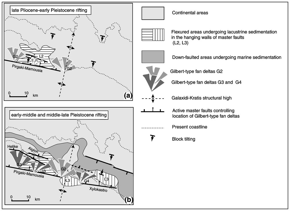
Schematic reconstruction of progressive Plio–Pleistocene rifting and fault segmentation in the sub-basins of Aigion and Derveni, separated by the Galaxidi–Kratis structural high.
Schéma de la progression du rifting Plio–Pléistocène et de la segmentation par faille en deux sous-bassins, celui d'Aigion et celui de Derveni, séparés par la crête structurale de Galaxidi–Kratis.
Le données de terrain suggèrent que les discontinuités mécaniques et lithologiques héritées de les épisodes compressifs de la chaı̂ne Hellénique ont joué le rôle de barrière persistantes pendant le rifting plio–pléistocène du golfe de Corinthe.
1 Introduction
In the hanging wall of the Hellenic subduction zone, progressive southward migration of the extensional front since Late Miocene has resulted in distributed extensional collapse, associated with the exhumation of lower continental crust in metamorphic core complexes [17]. A notable change in the orientation of extension occurs from the thickened crustal wedge (Crete and southern Peloponnesus), with prevailing systems of north–south normal faults, to the back-arc regions, where east–west-oriented normal faults are dominant. At the boundary between Peloponnesus and continental Greece, the Gulf of Corinth is one of the largest zones of seismically active normal faulting, cutting at right angles the Hellenic thrust belt.
The history of the inception, growth and migration of the fault systems that bound the Gulf of Corinth is written in the facies, thickness and age of the Plio–Pleistocene clastic wedge that fills the basin. Many pieces of this history have been reconstructed [2–4,6–10,23,24], but an issue that appears poorly focused is how the compressional structures inherited from the Neogene thrust belt control fault propagation and localisation of fault-bounded sedimentary basins. This issue has implications for modelling growth and segmentation of normal faults in a crust with both vertical and lateral heterogeneities and for understanding the role of lithological and mechanical barriers in relation to seismicity in the Gulf of Corinth.
In this paper, we focus on the presence of two sedimentary sub-basins on the southern shore of the Gulf of Corinth (Aigion basin to the west and Derveni basin to the east), separated by a transverse, north–south culmination of the Neogene Hellenic thrust belt across the Gulf from the north (Galaxidi Peninsula) to south (Kratis river valley). The distinct sedimentary evolution of the two sub-basins, bounded by east–west normal faults that do not crosscut the north–south structural high, suggests that lithological and mechanical heterogeneities inherited from the architecture of the thrust belt have acted as barriers for lateral fault growth during the Plio–Pleistocene rifting of the Gulf of Corinth.
The new field data on which we base our interpretation [12] result from the field mapping conducted in 2001–2002 in the framework of the European Community Project ‘Deep Geodynamic Laboratory Gulf of Corinth’ and synthesised in Fig. 1.
2 Plio–Pleistocene sedimentation on the southern shore of the Gulf of Corinth
Since the Late Pliocene, the geometry of the Hellenic thrust belt has been deeply modified by the crosscutting of east–west normal faults, with progressive foundering of the hanging wall panels, localisation of continental basins, and repeated marine ingressions [25]. The map in Fig. 1 shows the distribution of the sedimentary sequences in relation to the major basin-bounding faults on the south shore. A major contrast is apparent between the Aigion and Derveni sub-basins, respectively located to the west and east of the Kratis River valley.
2.1 Aigion Basin
Three depositional sequences separated by unconformities can be recognised in this basin (Fig. 1).
2.1.1 First depositional sequence
The oldest deposits discordant above the carbonate substratum are coarse conglomerates up to 500 m thick (unit fl1 in Fig. 1), of uncertain age (Early–Middle Pliocene?), that fill discontinuous troughs, bounded by high-angle normal faults dipping south and north.
2.1.2 Second depositional sequence
Above fl1 and the calcareous substratum lie lacustrine–lagoonal sands, marls and clays (L2, Late Pliocene–Early Pleistocene), deposited in an elongated, east–west-oriented depression, bounded to the south by the Pirgaki–Mamousia fault system (Fig. 1). These deposits are overlain by a thick sequence (>600 m) of conglomerates and gravels (G2, Early–Middle? Pleistocene), deposited as Gilbert-type fan deltas [9,19,24] that prograded from the Pirgaki–Mamousia fault scarp (Fig. 1).
2.1.3 Third depositional sequence
Unconformably above L2, the carbonate substratum, and G2 (Fig. 1) follow conglomerates and gravels (300–500 m thick) belonging to a Gilbert-type fan delta (G3), with foresets dipping 20–30° N, interbedded with horizons of marine marls and silty clays (Early–Middle Pleistocene). The northward descending staircase of the topsets is consistent with diachronous south-to-north progradation of the Gilbert-type fan deltas.
2.2 Derveni Basin
The oldest outcropping deposits of the Derveni basin are the conglomerates of the Akrata Gilbert-type fan delta, that drape the Kratis structural high (Fig. 1), and overlie the L2 sequence in the Aigion Basin. This stratigraphic position makes the Akrata fan delta relatable to the G2 depositional sequence.
The Akrata Gilbert-type fan delta is overlain by >1000 m-thick Pleistocene sequence of lacustrine silts and marls interbedded with alluvial plain fanconglomerates and nearshore cross-bedded sands, topped by alluvial gravels. This sequence (undifferentiated in Fig. 1) corresponds to the ‘first phase deposits’ of Ori [22] and is here attributed to the third depositional cycle (L3). Palaeocurrent indicators of sediment dispersal from west to east and proximal facies of L3 adjacent to the Kratis carbonate ridge [22] are consistent with the closure of the Derveni basin against the Kratis structural high.
2.2.1 Fourth depositional sequence
Discordant on L3 follow the Evrostini and Ilias fan deltas (G4, Fig. 1), separated by horizons of marine turbidites (‘second phase deposits’ in [22]). The age of this fourth sequence is undefined, and is here tentatively attributed to Middle–Late Pleistocene (see also [21]). The large thickness of G4 (>700 m), the steeply dipping foresets and the progressive down-stepping of the fan delta topsets from 1200 m (Evrostini) to 400–300 m (south of Derveni) are consistent with fan delta progradation in a highly subsiding basin that continues offshore in the present deep trough, filled with marine turbidites [3].
3 The Galaxidi–Kratis structural high
The architecture of the Hellenic thrust belt in the Gulf of Corinth is strongly disrupted by superposed normal faulting. A complete section through the outer thrust sheets is exposed only along a north–south transect that crosses the Gulf from the Galaxidi Peninsula in the north shore to the Akrata region in the south shore, and extends south along the Kratis River valley (Fig. 1). From north to south, the section exposes progressively deeper units, from the uppermost Parnassus thrust sheet (north shore) down to the Pindos and Gavrovo–Tripolitza thrust sheets and the Zaroukla unit (south shore). The exposure of phyllites in the Zaroukla window has been connected [11] to exhumation of a belt of HP–LT metamorphic rocks, continuous from Crete to the southern Peloponnesus, resulting from east–west extension in the fore-arc during the Miocene [18].
Along the Kratis valley, the Pindos carbonates crop out in a north-plunging, north–south anticline, bounded on the west flank by a low-angle (<30°), NNE–SSW normal fault. All the major normal faults of the Aigion Basin show a progressive decrease in offset towards the structural high of the Kratis River (see Figs. 7 and 13 in [20] for the Pirgaki and Helike faults). In the Derveni Basin, the Xylocastro fault appears to lose offset to the west, as indicated by the burial of the Pindos carbonates in its footwall beneath L3 and G4 along a continuation of the fault inferred from folding of the L3 cover sequence (Fig. 1).
Though none of the large normal faults crosscuts the Kratis structural high, its progressive foundering to the north appears to be controlled by the north plunge of the anticlinal axis and by the probable truncation by the offshore faults.
The offshore continuity of the Kratis structural high is imaged by the recently acquired swath topography map of the sea bottom [1], which shows a narrow north–south ridge at the boundary between the deepest eastern portion of the Corinth Gulf (>800 m deep) and the shallower, western portion. These two sub-basins are the northern continuation of the Plio–Pleistocene Aigion and Derveni basins in the present marine trough of the Gulf. The available east–west seismic profiles that approach the western margin of this submerged ridge [5,16] depict a thinning of the Plio–Pleistocene sedimentary sequence in onlap over a structural high in the carbonate basement.
4 Discussion and conclusions
The independent evolution of the Aigion and Derveni sub-basins during the development of the Corinth rift is made evident by the different sedimentary filling discordant above the carbonate substratum (depositional sequences L2, G2 and G3 in the Aigion sub-basin and L3 and G4 in the Derveni sub-basin, see Fig. 1) and is summarised in Fig. 2. In each basin the transition from lacustrine conditions in a shallow basin (L2 and L3) to increased rates of subsidence is recorded by the thick sequences of Gilbert-type fan deltas (G2, G3 and G4), that prograded into deep water basins bounded by steep scarps. Though the Pleistocene sea-level fall at ∼0.9 Ma has to be considered a major factor controlling the mass-flow discharge of the Gilbert-type fan deltas [25], the foundering of the present marine trough and the progressive uplift of the Middle–Late Pleistocene fan delta now outcropping on the south shore was largely controlled by activity of the Helike, Aigion, and Xylocastro faults. The depositional sequences mapped in the Derveni basin (L3 and G4) largely correspond with the ‘first’- and ‘second’-phase deposits distinguished in the same area by Ori ([22], see also [21]). However, the stratigraphic position of L3 and G4 above the topmost fan deltas of the Aigion basin (G3) is indicative of earlier extension episodes in the Aigion basin (Fig. 2(a)), controlled by repeated activity of the Pirgaki–Mamousia fault [12]. Our field data are not consistent with a progressive east-to-west opening of the Gulf of Corinth (see [2]), but rather suggest higher rates of subsidence of the Derveni Basin post deposition of L3 (Fig. 2(b)), eventually triggered by the high-rate, late activity of the Xylocastro fault [2].
The different timing of activity of the basin bounding faults (Pirgaki–Mamousia and Helike faults in the Aigion sub-basin and Xylocastro fault in the Derveni Basin) and their decrease in offset towards the structural high of the Kratis river have played a fundamental role in the diachronous opening of the segmented sub-basins on the south shore of the rift. The fact that the master normal faults do not cut across the Kratis structural high suggests that transverse discontinuities inherited from the compressional architecture acted as a persistent barrier during the Plio–Pleistocene episodes of rifting.
The role of lithological and mechanical discontinuities associated with the culmination of a thick stack of carbonate units and metamorphic rocks must be taken into account when modelling lateral growth of the east–west normal faults, varying depths of the low-angle detachments in the substratum, and different rates of seismicity in the western and eastern portion of the Corinth rift.