

1 The way forward: the meteorological example
Even if the supposed effect of a butterfly on the weather situation worldwide is more than exaggerated, it remains that the meteorological system is strongly interrelated: thus, a large cooperation is needed in order to collect the information allowing the national weather services to produce weather forecasts at all scales. This explains why, as early as 1853, was convened the first international maritime conference in Brussels. It led, in 1873 in Vienna, to the creation of the ‘International Meteorological Organization’ (IMO). The IMO was turned into WMO, in 1951, a specialized agency of the United Nations for meteorology (weather and climate), operational hydrology and related geophysical sciences. The mandate of WMO is to “facilitate worldwide cooperation in the establishment of networks of stations for the making of meteorological as well as hydrological and other geophysical observations related to meteorology, and to promote the establishment and maintenance of centres charged with the provision of meteorological and related services.” As indicated above, the advent of the space era brought a new dimension to the meteorological data acquisition. However, one surprising fact is that, long before it became technically feasible to assimilate the data acquired from space into numerical models of the atmosphere, space brought a new vision of the Earth's atmosphere, and completely changed its perception by humankind.
Progressively more and more satellite data (see Fig. 1) are becoming available, while at the same time the geographical coverage of certain in situ observations (e.g., radio-soundings) tends to diminish. In spite of the decline of part of the in situ observing capacity, skills of the medium range weather forecast have remarkably improved in recent years. This is largely due to the progress made in the numerical modelling, but also to the availability of space data: this explains, in particular, the rapid convergence (Fig. 2) of the northern hemisphere and southern hemisphere (poorly covered with in situ measurements) forecast skills.
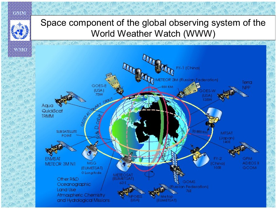
Localisation of present and new future meteorological satellites (courtesy of WMO).
Localisation des satellites météorologiques présents et futurs (document OMM).
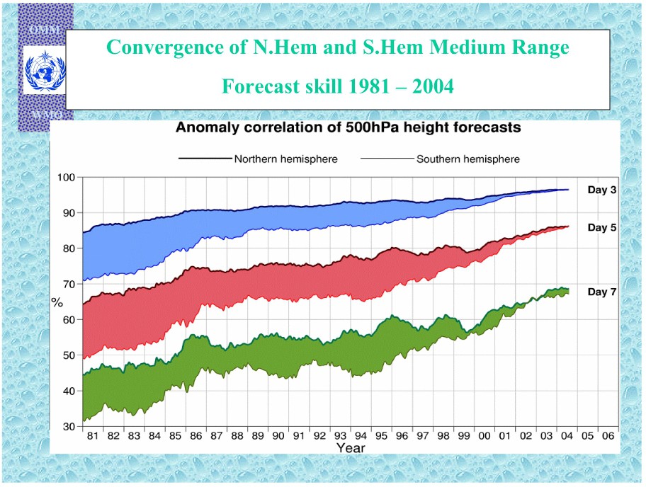
Evolution of the skills of meteorological forecasts in the northern and southern hemispheres (courtesy of WMO).
Évolution de la qualité des prévisions météorologiques dans les hémisphères nord et sud (document OMM).
The initial accomplishments, in the 1960s, of USA and USSR were incentive to other regions of the world, in particular, China, Japan, India and Europe. As far as Europe is concerned, the European Space Research Organisation (ESRO), predecessor of ESA (European Space Agency), decided in 1972 to launch the first European weather satellite (Meteosat-1, put in orbit in 1977). Its success led to the creation of EUMETSAT, which took over the Meteosat system in 1987.
In parallel, a COST (European CO-operation in Science and Technology) action is at the origin, in 1975, of the European Centre for Medium-range Weather Forecast (ECMWF), which provided its first real-time forecasts in June 1979 and became fully operational in August 1979.
Thus meteorology provides today the only operational civil systems built upon the combination of in situ and space data as well as numerical modelling for the purpose of satisfying user requirements, including scientific ones. This system benefits from recurrent funding allowing for a long-term planning of the needed operational equipments. Such a situation reflects the necessity to respond to societal and economical demand.
2 Ozone hole and climate change
Other growing environmental concerns, such as the stratospheric ozone depletion and the climate change, have emerged in the last 25 years, underlining the necessity of developing new operational systems. These emblematic examples illustrate the overall process by which global Earth observation, joined with political implications, help address major environmental issues.
During the 1970s, a concern arose about the possible impact of stratospheric supersonic transport such as the ‘Concorde’ airplane on stratospheric ozone due to the nitrogen oxides emitted by the high-altitude aircraft. The atmospheric chemistry science community developed then an intense activity and competition, which led to the surprising result that long-lived chlorofluorocarbons (CFCs) could be a catalytic source of destruction of the stratospheric ozone layer. This matter remained controversial until the discovery in Antarctica of a dramatic springtime (October) ozone depletion, first in 1982, at the Japanese station of Syowa (Fig. 3) and later, but much advertised, in 1985 at the station of the British Antarctic survey. These developments had consequences:
- • a political move about the impact of human activity on the global Earth environment;
- • the adoption, in Montreal, in 1987, of an international protocol to protect the stratospheric ozone layer; the latter stipulates that the production and consumption of compounds that deplete ozone in the stratosphere – chlorofluorocarbons (CFCs), halons, carbon tetrachloride, and methyl chloroform – were to be phased out by 2000;
- • the set up of an international effort in order to monitor the stratospheric ozone layer, using in particular space observations.
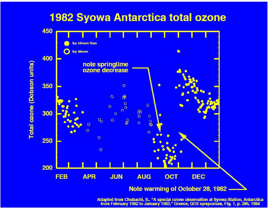
First observation of the Antarctic ozone hole at the Japanese station of Syowa.
Première observation du trou d'ozone antarctique à la station japonaise de Syowa.
This scientific effort has also been recognised by the award, in 1995, of the Nobel Prize in Chemistry to Crutzen, Molina, and Rowland.
This worldwide mobilisation for a global environmental question seems successful in as much as signs of a recovery of the ozone layer have now been recorded, although it is still uncertain whether they might be attributed to other effects, such as the influence of the solar cycle, other changes in stratospheric transport and temperature, or the high natural variability. The reason for such an achievement is threefold:
- • the observed effect (ozone hole) has a very large amplitude;
- • its causes are very well documented both in laboratory testing and on the basis of observations;
- • the economical impact of the ‘Montreal Protocol’, while of importance, could be dealt with relatively easily, as alternate solutions for the CFCs were available and that the number of industrial companies involved was small.
Climate change is also a major issue calling for a global and long-term monitoring of the Earth environment (oceans, atmosphere, cryosphere, land, biosphere). The linkage of atmospheric CO2 on a possible warming of the atmosphere was suggested as early as 1895 by Svante Arrhenius. The first convincing simulation of the effect of a doubling of the atmospheric CO2 concentration was made by Manabe and Wetherald in 1967. Mention of a possible climate change was then made during the world conference on the environment in Stockholm in 1972. Scientists warned the governments of the nations during the first world conference on climate held in 1979 in Geneva. This led to the creation of the intergovernmental panel on climate change (IPCC, a UN body). The next important step was the Earth Summit organised in Rio in 1992 by the United Nations. This summit stressed the necessity of reducing the emission of greenhouse gases (GHG) so as to allow a sustainable development of the world. The Kyoto Protocol, in 1997, gave a basis for a formal commitment of the governments upon their contributions in terms of reduction of the GHG emissions.
The issue of the global warming is much more controversial and complex than the one of the ozone depletion for a series of reasons:
- • while the increase of greenhouse gases atmospheric concentrations (see Fig. 4) as well as the 0.6 °C increase of the Earth global mean temperature during the 20th century are well documented, the establishment of cause–effect relationship is much more difficult to make, due to the complexity of the Earth system (both the carbon cycle and the climate processes implied in the greenhouse gas effect);
- • the economical and societal impact of a drastic change in the use of fossil energies will be tremendous, despite the fact that the effect of climate change itself should turn, in a matter of few tens of years, to be of dramatic importance.
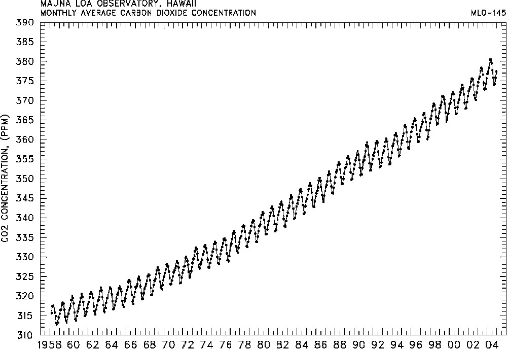
Monthly mean CO2 concentrations measured at Mauna Loa since 1958.
Concentrations mensuelles moyennes du CO2 mesurées à Mauna Loa depuis 1958.
Nevertheless, these two examples demonstrate the necessity to implement global long-term observations and numerical modelling systems.
3 The ‘best-effort’ approach to the global observation of the Earth
There are many other examples of different kinds relying on a similar combination of global Earth observations and public policies. One can quote prediction and alert systems for natural phenomena, such as tornadoes, volcanic eruptions, toxic phytoplankton bloom or El Niño events. Other systems deal with alert and impact – that is without prediction capacities, such as flood impacts or deforestation...
The need for a worldwide coordinated effort for monitoring the state of the planet Earth, stirred up by environmental issues and relayed at the political level, led to several coordination initiatives based on the principle of ‘the best effort’, implying that the national agencies involved would do their best to fulfil objectives commonly agreed upon.
- • WWW
The Word weather watch (WWW) is the core programme of the WMO since the creation of the organisation. Its main objective is to organise the necessary exchange of meteorological information between the national meteorological centres of WMO members to enable them to fulfil their national missions in terms of operational short- and medium-range weather forecast. This includes the operation of the Global Observing System (GOS), a data processing system and Global Telecommunication System (GTS) to collect data and disseminate products. The GOS includes not only ground based weather stations, upper-air sounding stations, but also elements at sea (ships, buoys and other ocean data acquisition systems), in the atmosphere (data acquisition from aircraft) and space, as described in Fig. 1 above. Under WWW are defined unified standards for observation, data acquisition and processing. Furthermore, the success of the WWW relies also on the use of the Resolution-40, adopted by the 12th meteorological congress and organising the exchange of the necessary data and products for operational weather forecast.
- • CEOS
In 1984, following a recommendation issued by the G7's working group on ‘Growth, Technology and Employment’ during the G7 meeting of Rambouillet (France), the major governmental organisations that are responsible for a civil space-borne Earth observation program decided to create the Committee on Earth-Observation Satellites (CEOS). With the objective of promoting the international growth and potential benefits of space borne observation of the Earth, the CEOS members agreed to coordinate informally their current and planned systems for Earth observation from space. A standing secretariat was established by the European Space Agency (ESA), the US agencies NASA/NOAA and the Japanese agencies MEXT/NASDA, and the host organisation chairs of a yearly plenary session.
The CEOS process happened to be a quite dynamical one, benefiting from the strength and the rather healthy financial situation of the space agencies. However, several weaknesses appeared progressively: the technically driven, rather than users', approach that characterises space agencies and the limits of the ‘best effort’. The first difficulty was somewhat overcome by the set up, in 1997, of the Integrated Global Observing Strategy (IGOS). The second one, political in nature, should find a solution with the GEOSS process launched in 2003.
- • GCOS
The Global Climate Observing System (GCOS) was established in 1992 to ensure that the observations and information needed to address climate-related issues are obtained and made available to all potential users. It is co-sponsored by WMO, the Intergovernmental Oceanographic Commission (IOC) of UNESCO, the United Nations Environment Programme (UNEP) and ICSU. GCOS is intended to be a long-term, user-driven operational system with four ambitions: providing the comprehensive observations required for monitoring the climate system, detecting and attributing climate change, assessing the impacts of climate variability and change, and supporting research toward improved understanding, modelling and prediction of the climate system. It addresses the total climate system including physical, chemical and biological properties, and atmospheric, oceanic, hydrologic, cryospheric and terrestrial processes.
- • GOOS
The Global Ocean Observing System (GOOS) was created by IOC in 1991 in response to the desire of many nations to improve management of seas and oceans, and to improve climate forecasts: both require to establish observations dealing with physical, chemical and biological aspects of the ocean in an integrated way. The vision guiding the development of GOOS is one of a world where the information needed by governments, industry, science and the public to deal with marine-related issues is supported by a unified global network to acquire, integrate and distribute oceanic observations systematically, and to generate analyses, forecasts and other useful products. GOOS is sponsored by IOC, WMO, UNEP and ICSU. The ultimate objective is to make GOOS the oceanic equivalent of WWW.
- • GTOS
The Global Terrestrial Observing System (GTOS) was co-established in January 1996 by UNEP, the Food and Agriculture organisation (FAO), UNESCO, ICSU and WMO. GTOS is a programme for observations, modelling, and analysis of terrestrial ecosystems to support sustainable development. GTOS facilitates access to information on terrestrial ecosystems so that researchers and policy makers can detect and manage global and regional environmental change.
- • IGOS
In 1992, CEOS took the initiative to bring together in situ (GCOS, GOOS, GTOS) and space (CEOS) data providers with the users community represented by ICSU, UNESCO (in particular IOC), FAO, UNEP and WMO. The outcome was the set up of an Integrated Global Observing Strategy (IGOS) agreed upon in 1997. The IGOS ‘partners’ met for the first time in 1998.
IGOS (Fig. 5) is a strategic planning process that links research, long-term monitoring and operational programmes, as well as data producers and users, in a structure that helps determine observation gaps and identify the resources to fill observation needs. IGOS seeks to provide a comprehensive framework to harmonise the common interests of the major space-based and in-situ systems for global observation of the Earth. It is being developed as an over-arching strategy for conducting observations related to climate and atmosphere, oceans and coasts, the land surface and the Earth's interior. IGOS strives to build upon the strategies of existing international global observing programmes, and upon current achievements. It seeks to improve observing capacity and deliver observations in a cost-effective and timely fashion.
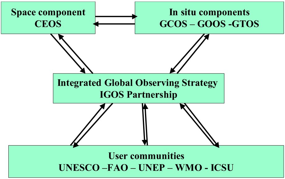
The IGOS partnership.
Le partenariat IGOS.
The major IGOS achievement has come through a thematic approach (ocean, geohazards, global carbon cycle, atmospheric chemistry, water cycle). The process of theme selection is based on an assessment of the relevant scientific and operational priorities for overcoming deficiencies in information, as well as analysis of the state of development of relevant existing and planned observing systems. Several important projects, such as the Global Ocean Data Assimilation Experiment (GODAE), comfort the Integrated Global Observation strategy.
4 The European environmental global monitoring program: GMES [1,2]
It appeared rapidly that a definite political push allowing to go beyond the ‘best-effort’ approach was needed in order to cope with the challenges of the evolving world environment. The first step in this direction was given by implementation of the Global Monitoring for Environment and Security (GMES) initiative.
In 2000, the European Union and ESA decided jointly to implement GMES, funded initially through the framework research and development program of EU and the Earth Watch program of ESA. GMES represents a concerted effort to bring data and information providers together with users, such that they can better understand each other and make environmental and security-related information available to the people who need it through enhanced or new services. GMES aims at designing and establishing by 2008 a European capacity for the provision and use of such operational services. The operational services constitute the backbone of GMES with the aim to provide continuous and everlasting observations through the building of the adapted perennial infrastructures.
Reviewing the various user needs, it was established that GMES will have to support the following EU objectives and policy domains:
- • Europe's environmental commitments, within the EU territory and globally, by contributing to the formulation, implementation and verification of the Community environmental policies, national regulations and international conventions;
- • EU policy areas such as agriculture, regional development, fisheries, transport, external relations including the integration of the environmental dimension in the respective domains and requirements;
- • Common Foreign and Security Policy (CFSP), including the European Security and Defence Policy (ESDP);
- • other policies relevant to European citizens' security at Community and national levels; notably, the potential exists for application to policies related to Justice and Home Affairs activities of the European Union, such as border surveillance.
A particular challenge is related to crisis management: this requires gathering relevant data and provides innovative, cost-effective, sustainable and user-friendly services, to provide appropriate decision-makers in real time for a large variety of circumstances.
The situation of the production of information presents the following shortcomings:
- • information is often not adequate, since it is neither always available in time nor reliable. Fortunately, the amount of observation data has increased in the recent years and ability to process them in real time has progressed with new sensor techniques and information technologies;
- • the production of synthetic and consolidated information is still very difficult. The variety of data, stemming from very diverse sources, with various time and space samplings, explains these difficulties;
- • the lack of a continuous monitoring leads to gaps and incompatibilities in data series or even interruption in series. Data collection based on research objectives often ends with the research programme that supported it.
The key challenge for Europe is then clearly defined: identifying the means to secure sustainable, coherent and efficient information for environment and security policies.
The GMES capacity is based on four inter-related components:
- • observations from space;
- • in-situ (including airborne) observations;
- • data integration and information management capacity;
- • services.
Today, efforts on GMES are placed on a user's service-driven approach rather than on a technology-pushed approach. From the users' perspective, the priority component is the provision of services to fulfil the policy and users' needs. The range of services available by 2008 will be developed progressively.
The provision of services relies on the space and in-situ components that capture the required observations. In addition, access to socio-economic and other statistical data will be important in order to provide the maximum added value to the information provided by Earth observations.
The data integration and information management will enable user access and sharing of information. These components will be developed in conjunction with the set of services that are required. Such a ‘build-as-you-need’ approach requires GMES to retain a modular open system approach that can easily accommodate new elements.
The main purpose of the current phase of GMES, under the auspices of the GMES Programme Office, is the gradual setting up of a number of ‘initial GMES services’, which should move away from the short-term logic of a ‘project’ and evolve into truly long-term sustainable services to the users.
Fig. 6 illustrates what has already been achieved in the case of operational oceanography with the MERCATOR system delivering, on a weekly basis, predictions of the global ocean state for the next fortnight.
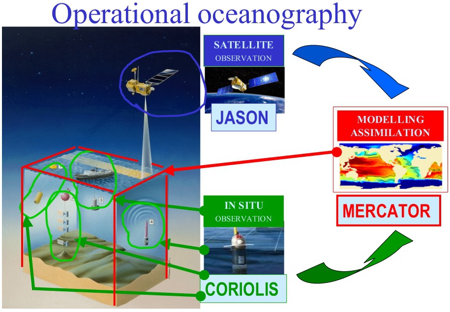
The MERCATOR system (courtesy of the GIP MERCATOR OCEAN).
Le système Mercator (document du GIP Mercator Océan).
The main characteristics of such initial GMES services can be summarised as follows:
- • mapping: consistent information from local to European scales;
- • forecasting: systematic information on the short to long-term evolution of Earth environment (air, water, resources);
- • crisis management: real-time and secure information for civil protection and security.
GMES is in a transition phase from a development-oriented program toward a system of operational services satisfying societal needs including research ones. Indeed, some research projects have already produced enough results to support a preliminary list of potential initial services:
- • marine & coastal environment;
- • risk management (floods & fires);
- • risk management (subsidence & landslides);
- • air pollution (local to regional scale);
- • land cover state and changes;
- • forest monitoring;
- • food security;
- • global change issues;
- • maritime security (transport, coastal, ice-monitoring);
- • humanitarian aid.
5 The Global Earth Observation System of Systems: GEOSS [3]
Today, the Earth system is apparently observed in all its aspects. But is it really the case? Are observation systems coherently and cost-efficiently defined and operated? Are not they redundant for some topics, while insufficient for others? Such questions have been raised by the G8 meeting in Évian (France), in May 2003. It was then agreed to build a better integrated global observation system over 10 years, to be kicked off through an Earth Observation Summit. The latter took place in Washington, D.C., on 31 July 2003.
This first summit, gathering 33 nations and 21 international organisations, decided to establish an intergovernmental group of experts, the Group on Earth observations (GEO), to define a 10-year strategy together with its implementation plan for adoption by a Summit to take place in early 2005. GEO, led by four co-chairs from USA, Japan, South Africa and the European Union has reached its objectives within 18 months, after a second summit in Tokyo in March 2004, and a third one, in Brussels, on 16 February 2005. There, the ‘strategy’ proposed by the GEO and its implementation plan was adopted and a new intergovernmental body, with the same name as the expert groups, GEO, was established. Its executive secretariat is installed within the WMO headquarters, in Geneva. Note that GEO is not part of the UN system and that, for the first time, an intergovernmental body includes the European Commission as a member. Yet GEO should work closely with the UN, searching new ways to raise resources for ensuring long term sustainability of observation systems. The best effort approach is not discarded, but will be politically supported, promoting cost-sharing, bur also raising the support of funding agencies from the public and private sectors.
The new GEO, fully operational since 1 January 2006, has the mandate to implement a Global Earth Observation Systems of Systems (GEOSS). This name is fundamental to understand the process. The adopted observation strategy should be built upon existing elements such as GCOS, GOOS and GTOS and shall use existing co-ordination bodies like IGOS.
GEOSS aims also to promote new systems only for domains of applications for which the existing systems cannot be used or for which new systems have to be built. Therefore, the GEOSS strategy has been built on a user-oriented approach, around nine societal topics, already identified during the 2002 World summit, in Johannesburg, and covering the whole Earth environment:
- • reducing loss of life and property from natural and human-induced disasters;
- • understanding environmental factors affecting human health and well being;
- • improving management of energy resources;
- • understanding, assessing, predicting, mitigating, and adapting to climate variability and change;
- • improving water resource management through better understanding of the water cycle;
- • improving weather information, forecasting, and warning;
- • improving the management and protection of terrestrial, coastal, and marine ecosystems;
- • supporting sustainable agriculture and combating desertification;
- • understanding, monitoring, and conserving biodiversity.
GEOSS will be a system of operational systems producing the useful information to meet the needs of policies and practices covering the nine topics listed above. One advantage of the concept is that synergy, at all levels, allows one to get more information with the same resources. Also, GMES, described above, is clearly in line with GEOSS: the GMES observations and data integration and information components will be the European contribution to it. This will complement or build upon other national programmes such as the European Meteorological Infrastructure, including space and in situ observation, forecast centres and product dissemination systems.
The practical work towards GEOSS started in January 2006. The success of the process will be evaluated if systems like GOOS, GCOS and GTOS will finally be implemented in a sustainable manner. One case exercise for GEOSS deals with the consequences of the 26 December 2004 tsunami: how to organise existing operators to develop and maintain an information system for disaster early warning at a global scale?
6 Conclusions
Humankind definitely needs a better management of planet Earth. As the latter is a dynamic integrated system, this requires global observations of all its components. This observation has to rely on a combination of in situ and space-based systems. Furthermore, what is needed by users and policy makers is information: data integration and management capacities, and prediction systems are key to their needs. As many issues are long-term, the system must be continuous. As the various issues change with time, and the technical tools evolve technologically at different paces, the overall system must be conceived in a flexible and evolving way, hence as a system of systems.
The dramatic evolution in technology of the last decade concerns all aspects of the systems: sensors, real-time data transmission, computer capacities... The science programs have allowed to understand the Earth well enough – despite obviously many gaps and questions – to make the construction of this system of systems for Earth management a possibility. This requires world-scale synergy and a political move. The GEO approach is dealing with those dimensions.
We also have ample demonstration that the investment required is largely exceeded by the socio-economic benefit of the information. Thus, it is time to move from conception, experimental demonstration and speeches, to action. In Europe, GMES is part of this action: it must be implemented at the appropriate level.