

1 Introduction
The quality of space geodesy and Earth science research depends to a large extent on the ability to obtain numerous, accurate geodetic measurements covering a wide spatial and temporal spectrum. The collection of natural changes that occur in the surface layers of our planet constitutes a challenge to the geodetic techniques and services because the terrestrial and space observing systems must be continuously maintained and updated. Over the last 40 years, different techniques have been developed to measure the position, velocity, and acceleration of objects orbiting the Earth: Doppler and laser tracking of satellites and Moon, Very Long Baseline Interferometry (VLBI) astrometry, and later, Global Positioning System (GPS) tracking. These techniques have been implemented by major space geodetic projects such as space oceanography and gravity missions, ensuring today, in 2006, high levels of accuracy and repeated spatial and temporal coverage of oceans, continents and atmosphere.
In that context, satellite and lunar laser ranging (SLR, LLR) provide unique instantaneous range measurements since more than 35 years. Thus, achievements of the laser ranging technique are the result of a long-term strategy. The first developments of this technique, at the end of the 1960s, were so promising that in the 1970s the idea came to have dedicated targets fully optimized for laser tracking (artificial satellites and retro-reflector arrays deployed on the Moon's surface) for several types of applications. The two first dedicated satellites, Starlette (launched by CNES in 1975, 800 km high) and LAGEOS (launched by NASA in 1976, 6000 km high) – followed later by similar satellites in the 1980s and in the 1990s: Stella (CNES, 815 km), LAGEOS-2 (NASA and Italian Space Agency, ASI), Ajisai (Japan, 1485 km), Etalon satellites (USSR, 19100 km), GFZ-1 (Germany, 398 km) – have been extensively used for measuring global solid Earth dynamics, and later, the large-scale mass movements on the Earth. Although the models of Earth's gravitational field rely heavily on radiometric observations (Doppler), the SLR measurements by virtue of their absolute, unbiased character provide a unique tool to validate the orbital and gravity field solutions and independently assess their quality. On the other hand, LLR was an early space technique for determining Earth orientation parameters; but if LLR data contributed to that objective, it is important to note the increasing ability of radio techniques like the VLBI and later the GPS, to determine and monitor Earth cinematic parameters at a very high level. Today LLR still competes with other space geodetic techniques, and because of large improvements in ranging precision (from 30 cm to less than 1 cm today), it now provides a unique capability in the solar system to test general relativity (equivalence principle, variation of the gravitational constant, and several metric gravity parameters).
Today, despite the limitations in coverage due to weather conditions and anisotropy of the laser network (in opposition to DORIS – French Doppler tracking system – or GPS networks) the laser technique continues to be used and continuously upgraded. The International Laser Ranging Service (ILRS) has been structured in 1998 by the SLR community, in view of (i) better organizing the overall laser tracking stations, (ii) taking into account drawbacks of the laser technique (biases and stability), and (iii) to enhance geophysical and geodetic research activities [29]. A clear example is the contribution to the implementation of the terrestrial reference frame (i.e. the ITRF), where the laser technique provides unique information on the location of the Earth's geocenter and, shared with VLBI, absolute scale.
We should reinforce the idea that, permanently observing the Earth (and planets) and its space environment today requires a multi-technique approach, that is the combination of very different data types. In this paper, we highlight the advantages and drawbacks of the laser technique, attempting to chart the future of this technique. Thus, the technology will have to be renewed in view of existing applications with new much more stringent constraints and of upcoming space missions: new space oceanography and gravity missions, time transfer mission using laser links around the Earth (i.e. the Time Transfer by Laser Link experiment scheduled on Jason-2), and future probe laser ranging in the solar system.
2 Laser Ranging: the technology
The advantage of SLR lies in its simplicity: the concept is based on measuring the round-trip time of a very short laser pulse, and its accuracy is based on very stable frequency standards in short considered time. It also relies on relatively low-cost retro-reflectors onboard satellites or stationed on the Moon by the American and Soviet missions from 1969 to 1973. Its main drawbacks are its dependence on favourable weather conditions and the need for dedicated personnel at ground level. To that point of view, SLR can be seen as the opposite of radio-electric techniques such as DORIS, GPS (and GLONASS), and the future Galileo European constellation, which provide an all-weather capability, are very easy to set up and use in the field, and for which the space-borne segments used are very costly. On the other hand, basic ground segments of SLR can always be controlled and improved from a metrology point of view and the life time of space laser segments (corner cubes) is quasi infinite (at least for LAGEOS and Starlette-Stella satellites, and for the Moon).
In the 1990s, new SLR technologies were developed to meet the evolving needs of the space geodesy community mainly amongst them being (i) shorter laser pulse length (from 1 ns to 35 ps at present), (ii) an increase of the laser rate of fire (from 0.1 to 10 Hz at present), and (iii) new detectors: avalanche photodiodes in Europe and micro-channel photo-multipliers in the United States [13]. Thus, the internal instrument precision ranges from few centimetres at the end of the 1980s to the millimetre level today, in terms of normal point (averaged measurements). Now, the different stations of the SLR network generally offer for individual shot an overall accuracy of the order of 8 to 16 mm for most of stations. This error budget (see Table 1) accounts for instrument instabilities despite regular calibration, atmospheric propagation, satellite signature, and local effects. Even if the overall accuracy of SLR is not easy to evaluate, it may be near 5 mm for a few stations.
Laser-ranging error budget (units in mm)
Bilan d'erreur de la mesure de télémétrie laser (unités en mm)
| Origin | Uncertainties | Systematic error |
| Laser | 4–5 | |
| (pulse) | (1) | |
| (width) | (4–5) | |
| Detector | 3–6 | |
| (start) | (1–3) | |
| (return) | (3–5) | |
| Timer | 2–3 | |
| Clock | 1–2 | |
| Calibration | 1 | 2–6 |
| (geometry) | (1–2) | |
| (electronic) | (1–4) | |
| Depend. (Az, El) | 1–3 | |
| Instrument | 6–9 | 2–6 |
| Atmosphere | 3–5 | 4–6 |
| (pressure) | (1–2) | |
| (temperature) | (1) | |
| (humidity) | (2–3) | |
| Target signature | ||
| T/P | 4–5 | 1–4 |
| LAGEOS | 1–3 | 1–3 |
| (Moon) | (1–50) | |
| Single shot | 7–12 | |
| Normal point | 1–3 | 8–19 |
As one of the result of the ILRS service, regular publications of comparative instrument bias data at different time scales and of normal point precision have created a competitive mood, which makes stations do even more to reach quality and performance requirements. As a result, stations can now detect technological problems without delay, inducing a much more effective contribution to improve range measurement accuracy, and above all to ensure better stability at scales of several months to one year or more (see, e.g., [21]). The geodetic products based on SLR, in particular those related to reference frames, are all the more accurate.
2.1 The laser French Connection
Since the beginning of SLR, the original effort performed by the French geodesy community (‘Groupe de recherche de géodésie spatiale’, GRGS) has to be emphasized. Starting in the 1970s, the French space agency CNES, the French mapping and survey agency IGN, and CERGA (now OCA) have developed a dedicated site for both SLR and LLR activities. It is located in southern France (‘plateau de Calern’, alt. 1280 m), near Grasse. The two stations were equipped with telescope of 1 and 1.5 m, respectively; they have been operating continuously since the beginning of the 1980s (Table 2).
Forty years of SLR and LLR activities in France
Quarante années d'activité de télémétrie laser (SLR ou LLR) en France
| 1965–1978: studies | cm 1 | Comments and technology 2 |
| First generation | 150 | laser: Rubis, 1 J, 20 ns, and 0.2 Hz |
| (Observatoire de haute Provence, January 1965) | chronometry: 20 ns | |
| with R. and M. Bivas | ||
| tracking: BEB satellite | ||
| First LLR observations | 200 | with O. Calame and A. Orsag |
| at ‘Pic du Midi’ (the Pyrenees) | ||
| Second generation | 20 | laser: Rubis, 1 J, 3 ns, and 0.2 Hz |
| 1978–1983: stations | ||
| Grasse SLR station | 20 | Telescope: 1 m |
| operational since 1979 | ||
| Grasse LLR station | 20 | laser: Rubis, 3 J, 3 ns, 0.15 Hz |
| telescope: 1.5 m | ||
| 1983–2005: operations | ||
| LLR (1986, upgrade) | 5 | laser: YAG, 300 mJ, 0.4 ns, 10 Hz |
| tracking: Moon | ||
| SLR (third generation) | 3 | laser: YAG, 100 mJ, 0.2 ns, and 5 Hz |
| tracking: LAGEOS, Starlette, Ajisai, ERS, TOPEX/Poseidon | ||
| SLR (1997, upgrade) | 1 | compensated avalanche photodiode |
| laser: 100 mJ, 35 ps, and 10 Hz | ||
| tracking: GFZ-1, Jason-1, ENVISAT | ||
| LLR (1995, upgrade) | 1 | better detection and chronometry |
| tracking: Moon, LAGEOS, GPS, Etalon and GLONASS | ||
| 1992–2005: FTLRS | ||
| French mobile system | 3 | laser: YAG, 100 mJ, 35 ps, and 10 Hz and avalanche photodiode |
| telescope: 0.13 m, weight: 300 kg | ||
| FTLRS (2000) | 0.8 | compensated avalanche photodiode |
| tracking: TOPEX/Poseidon, Jason-1 | ||
| campaigns: Corsica, Crete, Spain, and Corsica (2002, –03, –04, and –05) | ||
| 2005: the future | ||
| SLR | 1 | definitive stop |
| LLR | 1 | transformation to MeO system to track low to high orbiting satellites and the Moon |
| FTLRS | 0.8 | international opportunity request for future campaigns (south hemisphere, Pacific zone, etc.) |
| T2L2 experiment | 0.1 | T2L2: Time Transfer by Laser Link (scheduled on Jason-2, 2008) |
1 Precision of individual shot.
2 Laser pulse energy (in Joule) and length, and rate of fire; tracking of main targets only.
As a result of the increasing role of the French SLR and LLR systems in tracking both low and high earth orbiting satellites and the Moon, the Grasse site has been becoming a fundamental geodetic reference point. A permanent GPS station has been deployed in 1997, and several campaigns have been realized with mobile systems (VLBI, and FG-5 absolute gravimeter), thus reinforcing global and also regional studies for geodesy and geodynamics (e.g., tectonics of Alps, hydrology, etc.).
In view of participating in oceanography space missions (notably TOPEX/Poseidon, T/P, launched by CNES in 1992), an original and still unique mobile system, called the French Transportable Laser Ranging Station (FTLRS, see Fig. 1), has been developed. The idea behind this project was to build a very small SLR station (telescope of 13 cm in diameter, weight: 300 kg) that would be very easily transportable and could be installed, for example, in oceanic zones on islands and oil drilling platforms [28]. The main objectives of the FTLRS are to play an important role in space oceanography missions via satellite tracking, centimetre calibration of radar altimeters, positioning, and geodynamics [18]; during the past few years, the FTLRS has been deployed four times on different areas (see Table 2).
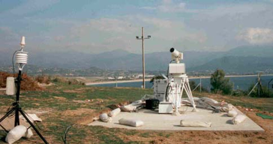
French Transportable Laser Ranging Station (FTLRS), deployed at Ajaccio, Corsica.
Station laser ultra mobile (SLUM), déployée à Ajaccio, Corse.
3 Satellite Laser Ranging: observing the Earth
Starlette and LAGEOS passive satellites have been tracked now for a long time of typically 30 years. Thus, the same targets can be used indefinitely for geodesy, geodynamics, and celestial mechanics, which is of great importance to maintain references from space. Among them, a precise gravity model is a prerequisite for precise orbit determination, altimeter data reduction, and tracking station positioning.
3.1 Earth Gravity field
As initially expected, LAGEOS has been (and is still) extremely used to determine the very-long-wavelength part of global Earth gravity field models, including the gravitational constant GM that defines the distance scale [16]. As also expected, Starlette, which is sensitive to the mean wavelengths (due to its lower altitude) has been used to determine numerous geodynamical parameters, particularly for the tidal potential [5,24]. In the 1990s, the growing number of available satellites gradually increased the resolution of the large-scale geoid to wavelengths of less than 1000 km at the Earth's surface [3,22,33]. For example, at its altitude (398 km; lifetime of four years) GFZ-1 was the lowest geodynamic satellite ever so far being ranged to by laser stations: it has demonstrated the possibilities and difficulties of tracking such low targets with state-of-the-art SLR systems (altitude at the end of the mission: 230 km).
While measurement precision for all (gravity) model parameters benefit from the ever-increasing improvement in precision of individual range measurements, some parameters of geophysical interest, such as time variations of the Earth's oblateness [37], particularly benefit from the long time period of range measurements. To directly detect the fine corresponding signals contained in the geodetic satellite orbits (secular and long-period perturbations), we have developed a dedicated method based upon the averaging of the motion equations [25]. It allows us to simultaneously determine both precise averaged satellite orbits and geophysical parameters over periods of 20 years and more [17]. Thus, the early SLR data are still important in the separation of effects with long characteristic time scales, such as post-glacial rebound and 18.6-yr tide [14]. Currently, data spanning 28 years from six to eight satellites are used for measuring the large-scale mass movements on the Earth [11]. This long-term history of the SLR measurements makes it possible for geodesists to determine the changes over time in melting glaciers and polar ice sheets and the associated sea level change. The main idea is that significant variations in the Earth's gravity field might be partially linked to the long-term global climate changes.
3.2 Orbitography
As an example of the continuous improvement of the dynamical model driving orbit precision and parameter estimation, orbital laser residuals computed over successive 10-day periods (orbital arcs) from normal point acquired on LAGEOS, range from 50 cm in 1976 to 10 cm in 1980, to 5 cm in 1985–1986, and then to 2 cm in 2000 (average rms). Today, typical SLR residuals obtained from LAGEOS precise orbit determinations show an rms of around 1.8 cm from 12–15 tracking stations, even if it is still possible to reduce this result to about 1 cm by carefully editing data and site coordinates, and by adjusting empirical coefficients in the dynamical model. Inversely, these coefficients have been used to precisely quantify non-gravitational forces linked to phenomena appearing on LAGEOS satellites [20,26].
In addition to this important contribution of SLR to dynamical modelling, absolute range measurements have been obtained also on the very high navigation satellites GLONASS and GPS-35 and -36 during the IGEX-98 campaign [36]. The goal was to calculate orbit errors at an accuracy level of 1 to 2 cm maximum, thus establishing external and absolute local and regional control points of such constellations that are tracked mainly by their own technique [2]. Likewise, the gravity missions launched in the early 2000s – CHAMP (Germany, 474 km high) and GRACE (US and Germany, 485 km) – to measure fine-scale features of Earth's gravitational field and time variable gravity require orbits that are accurately referenced to the Earth centre of mass. For these missions, GPS is used for permanently tracking the spacecraft orbits while SLR provides range vertical measurements that give the orbit scale very accurately.
3.3 Altimetry – Oceanography
The precise orbit knowledge required by recent altimeter missions – TOPEX/Poseidon (T/P) and Jason-1 (US and France, 1336 km), and ERS and Envisat (ESA, 800 km) – is a critical prerequisite to their ability to significantly contribute to oceanography. Right now T/P, which uses SLR and DORIS as its primary tracking systems, has been seeing an average yearly increase of about 3 mm in global sea level. Jason-1 continues the global sea-level measurements begun by T/P more than 11 years ago, building up a record of sea level change that may help explain the past and predict the future [6]. During this period, the main contribution of laser ranging has been to achieve ever more accurate range measurements, particularly at high elevations where the uncertainty related to atmospheric propagation corrections is the lowest. These SLR data, seen as absolute ones, have enabled us to compute orbits of accurate altitude and to control their radial error budget on an operational basis [4]; for example, the radial orbit precision of Jason-1 has now come down to 16 mm rms. Also, very good results have been obtained with altimeter satellites only tracked by laser: ERS-1, GEOSAT follow-on, and T/P at present (e.g., [32]).
Radar altimeter calibration experiments, or campaigns, play also an important role in addition to orbit validation activities; this is particularly true in view of mixing satellite altimeter data from several missions over decades. While the changes may be less than 1 cm (e.g., due to instrument drift), we take these changes in the altimeter very seriously as they clearly affect the scientific goals of space oceanography missions. For this reason, we have set up a semi-permanent site in Corsica with the lowest possible installation and monitoring costs, in collaboration with CNES and NASA. The FTLRS system, the role of which is to achieve centimetre accuracy locally for the orbit, has been deployed two times on this site already (in 2002 and very recently in 2005). T/P and Jason-1 have benefited from laser tracking during the calibration campaigns [19]. The size of the changes that have been investigated for T/P and Jason-1 and the large amount of effort already expanded show the difficulty of conducting long-term altimetry at the millimetre-per-year level. In this respect, radar altimeter calibration and orbit validation work undertaken for altimetry projects is extremely important.
3.4 Earth rotation, Geocenter motion, Terrestrial reference frame
The determinations of Earth orientation and UT1 at the 1-millisecond of arc level on the one hand, and of terrestrial reference frame parameters at the sub-decimetre level on the other hand began 35 years ago with SLR and VLBI. Since drastic improvements have been obtained at the international level regarding the accuracy and the operational features, ITRF2000 is the most extensive and accurate terrestrial reference frame ever developed and includes positions and velocities for about 800 stations located at about 500 sites [1]. From the available space-geodetic techniques, SLR is the one which provides unique information on the location of the earth's geocenter and, shared with VLBI, absolute scale. In particular, SLR is the most accurate technique currently available to monitor vertical motion, providing an absolute reference system for post-glacial rebound, sea-level and ice-volume changes. We should note that GPS and DORIS play a very important role in the ITRF solution, considering the homogeneous networks and the increasing quality and quantity of available data.
As initially expected, LAGEOS has been extremely used to determine station coordinates and velocities, and has largely contributed to the monitoring of polar motion and rotation of the Earth in association to other space techniques. At present, the laser technique through tracking data on both LAGEOS and LAGEOS-2 (around 2300 normal points collected per week) is able to determine a combined solution on a weekly operational basis: laser station coordinates computed every week and Earth orientation parameters computed at a 1-day interval [10]. The average internal consistency of the weekly coordinate solutions is of 12–15 mm, depending on the used process (constrained inverse methods), which corresponds to an accuracy of around 1–2 mm yr−1 in term of velocity. Concerning the great features of the global SLR network, if the total number of participating stations is stable since several years (around 40), the mean number of stations that observe 1500 satellite passes a year has increased from 15 to 19. Nevertheless, the network is still poorly distributed, particularly in the Pacific zone (southern hemisphere), although Haleakala (Hawaii), Tahiti, Arequipa (West of South America), and Mt Stromlo (East of Australia) systems. Currently, several of these stations have had technological, logistical, and/or financial problems, because what is perhaps less appreciated is how important the terrestrial reference frame is to other scientific experiments. One example is satellite altimetry, which uses DORIS, GPS, and SLR as tracking systems. Assessments of sea-level rise derived from studies of several and independent missions (e.g., T/P and Jason-1) directly benefit from accurate ITRF coordinates being used for the DORIS, GPS, and SLR tracking sites.
4 Lunar Laser Ranging: observing the complexity of the Earth-Moon system
4.1 Strength of the LLR, historical account
NASA put three panels of laser reflectors, on the landing sites of Apollo 11, 14 and 15. After more than 30 years, Lunar Laser Ranging (LLR) remains the only active Apollo experiment [15]. Two French panels were also put on the Soviet vehicles Lunakhod even if one was never detected. Very few stations are able to get returns, but it is enough to measure the Earth–Moon distance and thus to determine the accurate rate of getting away of the Moon (around 3.80 cm yr−1 or equivalent to −25.9 arcsec/century square for its secular acceleration). It is one of the few measurements of the energy dissipation within the Earth–Moon system. On the other hand, recent results based on TOPEX/Poseidon data enabled to locate in the mid North Atlantic an area where a significant part of energy is deposited through the dissipation of internal waves excited by the lunar tides effects against the bottom of the ocean topography [23,30].
With the passive nature of the reflectors and steady improvement in observing equipment and data analysis, LLR continues to provide state-of-the-art results. Gains are steady as the data-base expands (see Table 3); the big advantage of LLR is the long time span of lunar observations (1970–2005). Results exist in the field of solid Earth sciences, solar system ephemeris, terrestrial and celestial reference frames, lunar physics, and general relativity gravitational theory; they are shortly developed below.
Statistics of LLR observations (stations and reflectors), provided by Paris Observatory Analysis Laser Center [G. Francou and S. Bouquillon, private communication, 2005] and J.F. Mangin (private communication, 2005)
Bilan statistique des observations de télémétrie laser-lune (LLR), fourni par le centre d'analyse de Paris [G. Francou et S. Bouquillon, communication personnelle, 2005] et J.F. Mangin (communication personelle)
| Stations (1969–2004) | % | Comments |
| MacDonald (US)⁎ | 24 | Telescope 2.7 m; 1970–1985 |
| 2 | Telescope 0.76 m; MLRS-1 | |
| 17 | MLRS-2 (1988–) | |
| Grasse (F)⁎⁎ | 6 | Tel. 1.5 m; Rubis (1984–1986) |
| 48 | YAG⁎⁎ (1987) | |
| Matera (I) | <1 | |
| Haleakala (Aus) | 3 | Telescope 1 m; (1987–1990) |
| Reflectors (1988–2004) | % | |
| Apollo 15 | 79 | |
| Lunakhod-2 | 2 | Interesting for libration |
| Apollo 14 | 9 | |
| Apollo 11 | 10 | |
| Accuracy (1975–2004) | cm | |
| 1960s | 200 | McDonald Observatory |
| 1970s: | ||
| – ∼1970 | 25 | |
| – ∼1975 | 15 | Timing system improvements |
| 1985–90 | 3 | MLRS and Grasse |
| 1992–1996 | 0.7 | id |
| 1997–2004 | 0.6 | id |
⁎ Around 15 (1) and 30 (2) echos per Normal Point (= 10-min measurements), respectively.
⁎⁎ Performance of detectors (in the single photoelectron mode): 20–25 ps for green, and 100–75 ps for Infrared.
4.2 Celestial mechanics
The lunar ephemeris entirely relies on LLR data. The complications of the orbit are handled by numerical integration (translation and rotation) in the JPL's solution. However, analytical theories fit to the integrations provide information on the behaviour of the orbital elements. A specific characteristic of the Paris Observatory's approach of the lunar problem is the use of analytical solutions for the orbital motion and for the libration of the Moon [7]. Analyses of LLR observations from 1972 till now have allowed us to determine the lunar and solar parameters of the motion (in particular lunar and solar mean motions useful for long term predictions), the tidal deceleration of the lunar mean longitude, the ‘observed corrections’ for the motions of perigee and node [8]. Taking advantage of the natural separation of the forced and free libration in an analytical solution, Chapront et al. have also fit the free libration parameters providing a solution for the ‘free component’ of the lunar rotation vector. The precision (rms) of the over-all fit nowadays is 3 cm. Because the Moon is the most important tide-generating body, the capability of LLR to determine tidal parameters has been carefully investigated by several authors [35].
In addition, the LLR technique is sensitive to the orientation of the Earth with respect to the lunar orbit. Hence, the components of a rotation matrix to refer the dynamical frame (motion of the Moon) to the celestial reference frame have been determined: a by-product of this determination is a correction to the precession constant [9]. The analysis of LLR data also enabled the determination of several geometrical parameters, such as reflector coordinates on the Moon's surface.
4.3 Fundamental physics
The US community is also pushing the LLR experiment as well, especially on a long-term basis, considering the challenge of having at our disposal a long time series to explore the Equivalence Principle through our unique Earth–Moon system. The fitting of 28 years of LLR data for a possible range signal indicating an Equivalence Principle-violating difference in the gravitational acceleration rate of Earth and the Moon toward the Sun has been performed and then examined, both analytically and by computer simulations [27]. A synodic post-model residual signal of characteristic size 1 cm was found in the data but, as far as we know, not yet interpreted. It strongly indicated that LLR observations should, for some time into the future, preferentially be made on the new Moon side of the quarter Moon phase.
At the moment, LLR remains the best natural tool in gravitational physics to test the equivalence principle (at several 10−13) [12]. Its interest will be dwindling with space projects like Mini-Step (US) or MicroSCOPE (France, to be launched in 2010) [34] for testing the weak equivalence principle up to 10−18 and 10−15, respectively. But it is not true for the strong EP only accessible through observation of the Earth–Moon system's dynamical behaviour. Due to the increasing amount of LLR data, the EP should be tested, hence, up to few 10−15 in the 2010s.
5 Laser Ranging: future objectives
5.1 Technology and network
The laser community is studying several ideas concerning the network, the efficiency of the laser pulse (particularly when tracking the Moon's targets), and the precision and accuracy of range measurements. In our opinion two factors are essential in the future of SLR technique: the improvement of the worldwide coverage and of the measurement stability (the ability of the technique to permanently ensure the same data quality and thus accuracy) over long time periods of typically 1 year and more. The coverage will be improved first by improving the current less precise and productive stations, and second by deploying mobile and other ‘light’ systems (FTLRS, other LLR stations, and the expected US SLR2000) in areas where the impact of the tracking could be very great (southern hemisphere, Pacific and Indian oceans). The improvement of the precision and accuracy of range measurements to the absolute millimetre level is currently studied by several groups through a very short pulse duration (from 30–35 to 10 ps), the increase of the fire's rate (from 10 to 1000 Hz), and the adoption of new event timer (). In addition to these great technological features, SLR and LLR analyses have demonstrated the necessity of decreasing the target signatures to 1 mm or less without loss of returning signal.
5.2 Time transfer
In the time and frequency domain, the comparisons of up-to-date standards are still very complicated to set up, but this kind of experiments is more and more crucial to realize. In addition, due to the development of space projects (notably the Galileo navigation system), because time and frequency standards could be better in space than at ground level, several space techniques of time transfer have been developed. The Time Transfer by Laser Link experiment should be placed on-board Jason-2 (2008). The objective is to realize this time transfer with an accuracy of about 50 ps and a temporal stability better than 1 ps over 1000 s of integration, which represents an improvement of more than one order of magnitude with respect to present techniques. This experiment should demonstrate for the first time the capability of the laser tracking technique to realize the calibration of other navigation systems like GPS and the future Galileo project. Other techniques are under development; they are based on radio-electric frequencies, which permit a use on an operational basis and are easy to be deployed, in opposition of ones based on laser.
5.3 Long distances
The laser technique that characterises the ‘Télémétrie interplanétaire optique’ (TIPO) project is based on a one-way range measurement mode. It should permit to realize measurements over several billions of kilometres through the solar system without a very complicated technology to be developed as in space (on a solar system probe) as at ground. The performances of the one-way technique, as it is proposed with TIPO, are extremely dependent of the clock performances to be used on-board the probe. In a short future, the development of space clocks having a frequency accuracy of 10−16 should permit to measure an absolute range at the 1 meter level and to reach the sub-centimetre level in measuring relative distances over several days of integration. The idea is to avoid drift of the embarked clock relative to Earth's clocks. Then, future applications in the solar system can be investigated, as for navigation or celestial mechanics as for fundamental physics. Such a project exists now and could be developed.
6 Conclusion
The laser technique has been developed since 40 years. Numerous improvements have been made in precision and in operational modes. The progress made by the other geodetic (satellite-based) techniques, such as GPS and DORIS, are also very great (see their contributions to ITRF solutions and to the tracking of space missions). But it is absolutely clear that the laser technique will continue to have an irreplaceable role in many fields: determination of global space scales (Earth's shape and size), location of the Earth's geocenter, monitoring of vertical frames, role of calibration–validation in basic fields (including time transfer), capability to track passive satellites and may be space debris in the future, etc.
The laser one-way technique, in association with accurate clocks, appears to be the most accurate technique to measure very long distances (several 1012 meters) in the solar system. Thus, this technique could play a very important role in terms of navigation, celestial mechanics and fundamental physics.
Acknowledgements
We would like to express our grateful thanks to the laser French teams for their know-how of problems, and to the CNES space agency. The European, American and international cooperation, especially through the EUROLAS consortium and the International Laser Ranging Service, were essential factors of success.