

1 Introduction
South Africa boasts an extremely rich rock-art heritage. Although this art encompasses a large variety of traditions and techniques (e.g., [7,28,32]), it is the San (Bushman) rock paintings [15,18] that are best known to the public. Rock-art sites, both engraved and painted, count in the thousands all over the territory of South Africa. In an overwhelming majority, they are in open-air sites, on boulders, glaciated pavements, or rock shelters. They are therefore open to the elements and subjected to a full range of natural weathering processes jeopardising their survival. The conservation of rock-art in South Africa has attracted the attention of researchers from various scientific fields since an early date [1,11,21,26,27,29,31,35–37]. Besides pointing at vandalism as the first and the foremost danger, these studies recognise various natural weathering processes as responsible for the damage to rock-art, depending on the geological and environmental conditions. A crucial problem in identifying the exact cause of damage to rock-art by scientific means is the need to collect samples for analyses, and therefore contribute to the alteration of the art. Efficient and accurate non-destructive tools to assess the conservation condition of rock-art sites are therefore badly needed. Such tools must also be non-invasive and respect the sensitivities of local communities who attach spiritual values to the rock-art. In South Africa, rock-art sites are also usually in remote and difficult-to-access places, often in mountainous areas, and can be reached only after long walks. For this practical reason, the equipment for conservation assessment must be light and easy to carry and operate with low-power supplies.
One such equipment is the Ground Penetrating Radar (GPR). It was originally used for ground geological investigations and the identification of discontinuities within rock beds [5]. It quickly became of common use in archaeology to detect buried structures [3,4,10,16,19], but has never been used to assess rock-art conservation conditions. This technique presents, however, a very high potential for this application. Besides meeting the above requirements of manoeuvrability, non-destructivity and being little invasive, the GPR can localise and evaluate the development of discontinuities in depth, behind the rock wall, and give a three-dimensional view of potential instability sources. The GPR appears therefore as a particularly adequate tool to investigate the stability of painted rock shelters and to help in the design of efficient and proactive conservation measures.
The GPR was tested for the assessment of conservation condition at two San rock-art sites in the uKhahlamba-Drakensberg Park (KwaZulu-Natal, South Africa), which was inscribed in 2000 by the UNESCO on the list of the World Heritage Sites, on both cultural and natural criteria (Fig. 1). The first site, Game Pass Shelter (GP), is one of the most prominent public rock-art sites in South Africa, and its significance for the understanding of San rock-art [2,17,18] as well as its cultural value are well recognised. Its conservation is therefore of crucial importance. The site, which is in the Kamberg Nature Reserve, also benefits from an exemplary management, and risks of new damage are expected to be of natural origin. The second site will be referred to as LOM1. It is not protected by any specific measures and to ensure its protection its name cannot be disclosed.

Location map showing the two investigated sites.
Fig. 1. Carte montrant la localisation des deux sites étudiés.
These two sites are typical of the painted rock shelters found in the area (that shows one of the highest concentration of rock-art in South Africa), and tests made there are relevant for the other many sites found in the same geological formation.
2 Background
In 2002, an interpretative centre was opened at GP to provide visitors with information on the paintings and their authors [2]. The conservation condition of the site is now monitored on a regular basis by the Rock-art Research Institute (University of the Witwatersrand, South Africa). The shelter is fenced off and the visit of the rock-art site is allowed only under the supervision of trained guides. The management of the site should prevent human agency, damages by large animals and the propagation of veld fires in the direct vicinity of the rock shelter. LOM1 does not benefit from any particular management and conservation plan and unsupervised visitors often go to the site because of its proximity to an area of intense tourist activity.
GP shelter is cut in a large sandstone outcrop at about 1970 m above sea level and facing towards the NNE. The shelter is about 80 m long and covered by a large overhang (about 4 m high and between about 5 and 8 m wide). The paintings, attributed to San hunter-gatherers [17], are grouped into four panels. The two most significant panels (Figs. 2–3) are the so-called Main Panel and Dying Eland Panel (DEP). LOM1 is a small shelter (about 15 m wide) at about 1850 m above sea level, facing south. The overhang is about 3 m high and 6 m wide. The paintings, also attributed to San people, are regrouped on a single panel (Fig. 4).
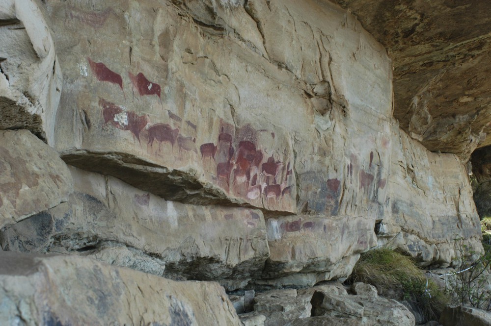
GP. Main panel.
Fig. 2. GP. Scène principale.
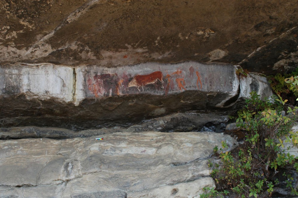
GP. Dying Eland (Taurotragus oryx) panel.
Fig. 3. GP. Scène à l’élan (Taurotragus oryx) mourant.
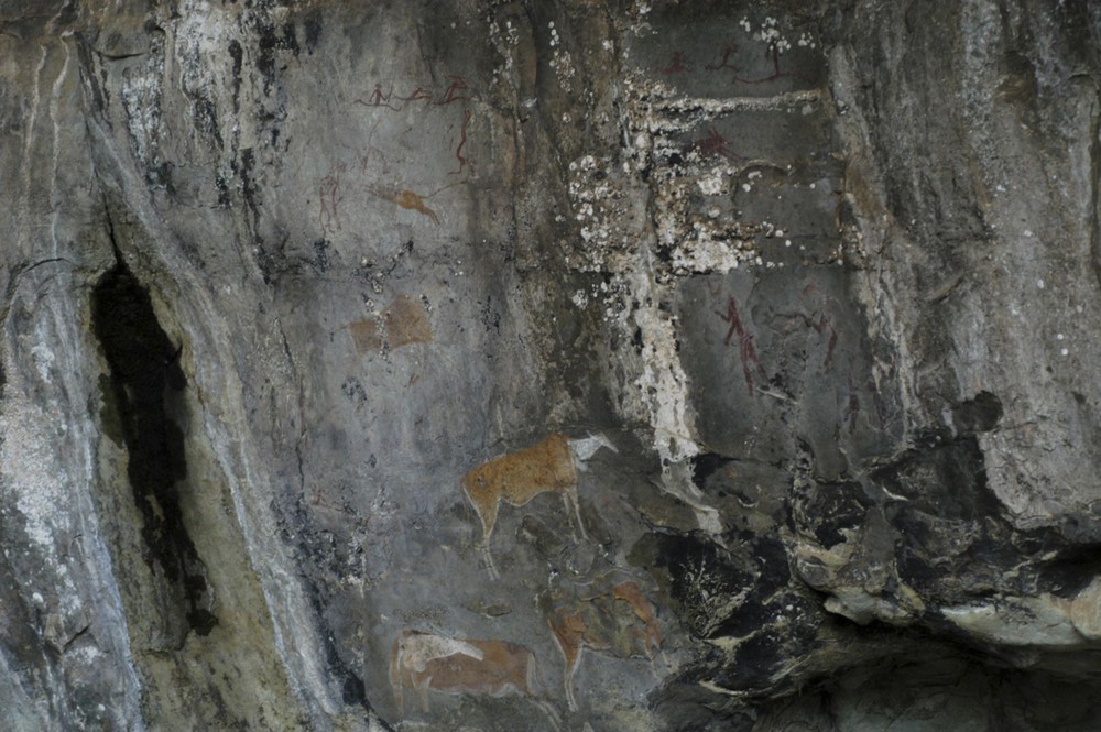
LOM1. Main Panel.
Fig. 4. LOM1. Scène principale.
At both sites, the paintings are now of red, brown, orange, white, and black hues. No chemical analysis of the paints has ever been done there. The pigments used by San people in this area are often referred to (through chemical analyses and/or ethnographic analogies) as being different iron oxides or oxy-hydroxides for the red, brown, and orange pigments, charcoal, manganese or iron oxides for black pigments and clay (kaolin), gypsum or zinc oxides for white pigments [30,33,34].
The paintings at GP and LOM1 have never been dated by any scientific means and little can be said about their possible age. The superimposition of figures, their different ‘styles’, and various degrees of conservation suggest that paintings on a single panel can be of very different ages. Only to give an order of magnitude, historical and archaeological evidence [22], radiocarbon dating of plant fibres embedded in the paint [23] and of oxalate crusts formed under or over the paintings [24] and dating using the rate of decomposition of amino acids [6,but see 30] suggest that the age of the analysed surviving San rock-art in this part of South Africa can range from a couple of hundred years to about four thousand years.
The sites, like most painted rock shelters in the KwaZulu-Natal Drakensberg, are found in sandstones of the Clarens Formation, dated from the Late Triassic (Fig. 5). These sandstones are of aeolian origin, their thickness ranges from 100 m to more than 230 m [14,20], and they are covered, at a regional scale, by important basalt flows dating from the Early Jurassic. Petrographically speaking, the Clarens sandstones are composed of quartz grains, marginally associated with feldspars. They appear as layers of finely sorted sandstones of colours ranging from ochre to rust [8]. Between the layers, there are clay joints of bluish colour, which can reach a few decimetres in thickness. Some sandstone layers show abundant sedimentary figures of cross-layered stratification that attest to a partly alluvial origin.
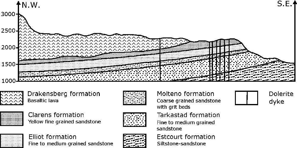
NW–SE Geologic section of the Drakensberg, perpendicular to Game Pass Shelter scarp (from [17]).
Fig. 5. Coupe géologique NW–SE du Drakensberg au droit de l’escarpement à Game Pass Shelter (d’après [17]).
The Clarens layers are widely fractured, which causes the broken aspect of the principal scarp. In the studied area, the fracturing is mainly oriented 60 ° from the north and is therefore orthogonal to the orientation of the scarp at GP (mainly comprised between 120 ° and 150 ° from the north). The dip of the sandstone layers is relatively low, varying around 3 and 5 degrees to the northwest. This confers a pseudo-tabular and monocline structure to the sedimentary ensemble. The massive structure of the sandstone layers and their natural tendency to break out in metre-large blocks constitute a major risk for the conservation of the sites. This is well evidenced at GP by the accumulation at the base of the scarp of sandstone blocks that can reach about 50 m3.
At both sites, the paintings are rather well preserved. The aeolian sandstones of the Clarens Formation are mostly affected by a combination of thermal stress fatigue associated with rock moisture regime variations [13,25,26], which causes the development of large scales and many flakes. A preliminary assessment of the major risks at GP [12] also points at several water seepages close to the paintings, with the possible development of microbiological threats in these wet areas (especially on the DEP). At LOM1, the paintings are menaced by the build-up of accretions and the proximity of several active water seepages. In addition to weathering, the fracture pattern of the rock, at the origin of the rock shelters that make the fame of the Clarens Formation (it used to be called Cave Sandstone), often jeopardises the integrity of the rock-art. Discontinuities observed at both sites either result from weathering processes or are of geological origin. Geological discontinuities comprise, for instance, fractures, extension joints, and clayey stratification joints. At a larger scale, the intense vertical fracturing of the whole cliff is associated with the existence of thin clayey and low-resistant interstratified levels (stratification joints) that are responsible for the cutting of the painted walls in many metre-large blocks. Some of them seem highly unstable, but a visual identification of discontinuities emerging on the rock surface is insufficient to evaluate the potential risk of instability. Knowledge of the spatial extension of the discontinuities within the rock and of their width, and an evaluation of the quality of the connection of the rock blocks with the whole scarp are required to assess correctly the conservation threats.
3 Methods
The GPR is a survey method that utilises the properties of electromagnetic waves and their interactions with soil or rock. The propagation of electromagnetic waves is described by the Maxwell Equation, where two regimes can be distinguished: a diffusion regime associated with conduction phenomena and a propagation regime linked to polarisation phenomena. The GPR belongs to the high-frequency (from a few tens of MHz to several GHz) electromagnetic methods, where polarisation phenomena predominate [3,5].
At a point of the surface, an emitter antenna sends waves as very short time pulses. While travelling through the soil, and depending on its permittivity, these waves create polarisation phenomena. When the waves meet a dielectric contrast, they are partially reflected back to the surface. There, the amplitudes of the reflected waves are measured by a receiver antenna. These readings are a measurement of the amplitude of the electrical field that results from the reflections and diffractions on the dielectric contrasts of the soil as a function of the propagation time of the waves. Their analysis gives access to the electromagnetic properties of the soil.
The results are first given as a raw radargram (or time section), where the amplitude of each signal, graduated in colour levels, is shown as a function of the propagation time (vertical scale). The signals are juxtaposed as a function of their position on the surface (horizontal scale). The first and basic step in the processing of these raw data is to build an interpreted radargram (or depth section), where the vertical scale of time is replaced by a vertical scale of depth (for an illustration, see Fig. 6). This is implemented from the knowledge of the relative dielectric constant of the studied medium.
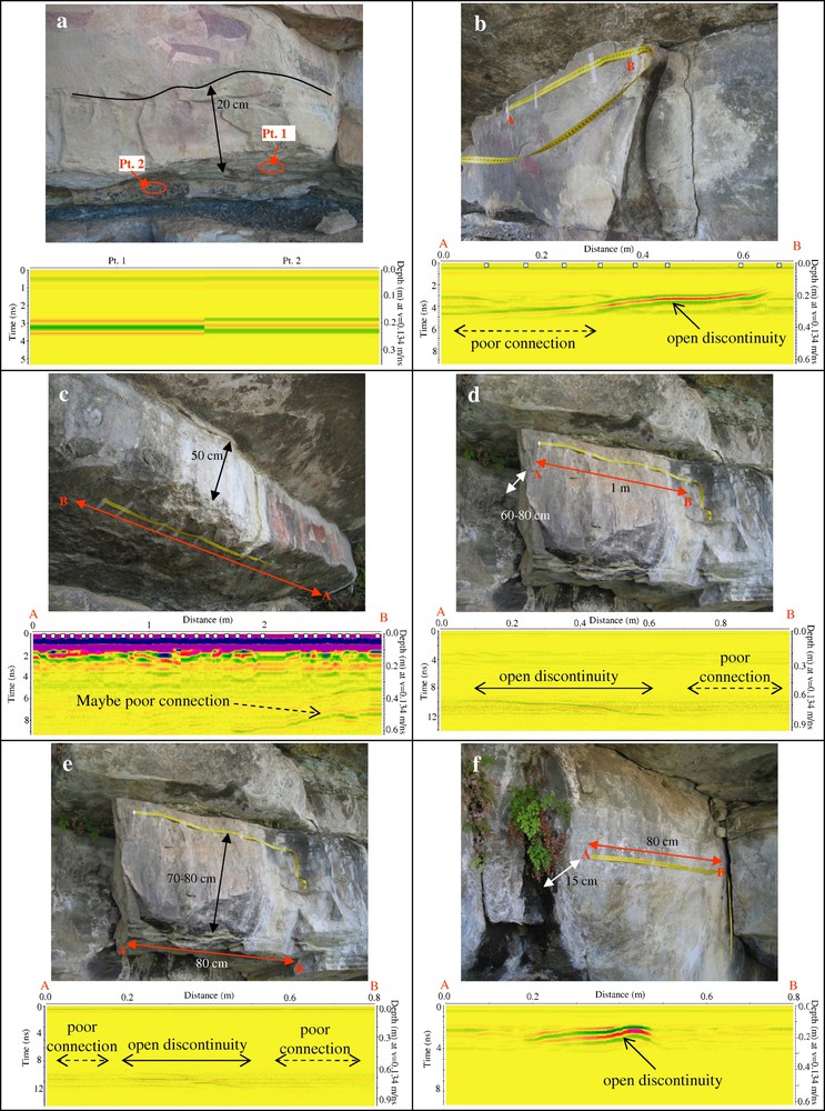
(a) GP. Main Panel, point measurements. (b) GP. Major scale. (c) GP. Dying Eland Panel. (d) LOM1. Overhanging slab menacing the paintings, longitudinal profile. (e) LOM1. Overhanging slab menacing the paintings. Measurements performed under the ledge. (f) LOM1. Wall just below the overhanging slab (e), right of the panel with most of the paintings.
Fig. 6. (a) GP. Scène principale, mesures ponctuelles. (b) Grande écaille. (c) GP. Scène à l’élan mourant. (d) LOM1. Surplomb menaçant les peintures, mesures longitudinales. (e) LOM1. Surplomb menaçant les peintures. Profil mesuré sous le surplomb. (f) LOM1. Paroi en dessous du surplomb (e), juste à droite du panneau principal.
A GSSI SIR-2000 detector (model DC-2A/3400) is used in this study. The frequencies utilised are of about 1.5 GHz and allow investigation depths varying between 4 and 80 cm, depending on the resistivity of the medium. The electromagnetic waves have no harmful effects on the rock or the paints.
Measurements can be made as continuous sections or on a point, according to the fragility of the studied rock or the presence of art.
Before any investigation of the stability of painted rock walls, tests (not detailed here) were made to determine whether the equipment could be used on Clarens sandstones, and what could be the most adequate value for the dielectric constant. That is, to determine the depth of penetration of the electromagnetic waves and the possibility to identify the discontinuities of interest for conservation. These preliminary tests show that the GPR can detect: (i) rock scales of small width (10–20 cm), (ii) the presence of moisture in clayey joints, (iii) more in depth, the presence of open cracks that might result in the instability of entire rock blocks. A dielectric constant of 6 (consistent with the nature of Clarens sandstones) was selected for the whole study.
4 Results and discussion
We present here a selection of field measurements (Fig. 6) to illustrate the potential of the GPR for the assessment of the conservation condition of rock-art sites.
In Fig. 6a, two point measurements were made under the layer instead of a continuous profile because of the rock surface geometry. These measurements show the presence of an interface between 18 and 25 cm (also visible on the surface) that goes deep into the rock. Although it looks closed on the surface, the interpretation of the radar image shows that it is clearly discontinuous in depth. However, no sign of short-term instability has yet appeared on the surface.
The block in Fig. 6b shows an important detachment visible to the naked eye. The aim of the radar measurement is to evaluate the extension of the detachment in depth and over the entire length of the block. The radargram shows that the block may not be detached over its entire length. Between 0.40 and 0.65 m, a zone where the reflexion is much stronger can be seen on the radargram. This may be interpreted as an open discontinuity, whose stability is not ensured in the short term. Further opening of the discontinuity from A to B is to be feared. It would cause a general instability of this rock block.
In Fig. 6c, the presence of water seepage close to the upper joint on this layer (DEP) suggests the existence of an open discontinuity. However, even after processing, the radargram does not show any clear discontinuity (note that the blurred shape of the radargram is due to a strong amplification of the signal, which also increases the measurement noise). Towards B (zone with the most active seepage), the radargram nevertheless shows reflected waves that might indicate a discontinuity at about 50–60 cm depth. At the time of the measurement (during austral spring), the water seepage was completely dry, which may explain the bad signal.
Fig. 6d and e show the investigation of the stability of an overhanging rock slab at LOM1. The slab is just above the painted panel and visual observations suggest a loose connection with both the vertical rock wall and the roof of the shelter. This is confirmed by radar investigation. In Fig. 6d, a discontinuity can be seen between 70- and 80-cm depths. On the longitudinal profile, this discontinuity looks more open between 0.10 and 0.60 m than between 0.70 and 1 m, where the reflected waves are of lower amplitudes. This shows that the overhanging rock slab is not well connected to the rock-shelter back wall, especially on the left side. The discontinuity gets deeper to the right and it is no longer possible to localize it with the GPR equipment used or to investigate the quality of the connection farther to the right.
This block also appears loosely connected to the roof between 0 to 0.20 m and between 0.50 and 0.80 m on the longitudinal profile (Fig. 6e). Between 0.25 and 0.50 m, the joint is more clearly open. This suggests a rather poor stability of that overhanging block. Although the block is not carrying any paintings, its fall will endanger the paintings just below.
Because the length of the rock slab (about 2 m) is longer than the penetration depth of the GPR, it was not possible to investigate the quality of the lateral connection.
The rock wall investigated in Fig. 6f is just under the left-hand and least stable part of the overhang discussed above, to the right of the panel with most of the paintings (Fig. 4). The radargram shows a strong signal at 15 cm depth, especially about 0.30–0.40 m from A, which is an active seepage. This might reveal the presence of an open discontinuity running parallel to the rock wall, which works as an easy path for water on its way out. In any event, this part of the rock wall does not show a strong cohesion and this contributes to decrease even more the stability of the overhanging rock slab just above.
In the Clarens sandstone, the best GPR results are obtained with clayey sedimentary joints, open tension joints, and joints saturated with infiltration water. The GPR resolution is however not able to show clearly shallow discontinuities, like flakes or very superficial scales, insofar as the first centimetres of the radargram are often perturbed by direct waves of strong amplitude (‘near-field zone’). The resolution in the ‘near-field zone’ is difficult to improve by signal processing, as it is a constraint related to the physics of wave propagation. According to [9], there might be usable information in the near-field zone when accurate time-zero is chosen and near-surface reflections are processed. It should also be possible to obtain a better resolution of the readings by using an antenna allowing higher frequencies.
The contrast on the radargrams is increased by the presence of water or air within the discontinuities (as shown in Fig. 6f). This preliminary investigation has been carried out during the dry season and better results might be expected during the wet season. Then infiltration water should circulate in greater quantity along major cracks or saturate argillaceous joints and allow a stronger contrast in the reflection of the electromagnetic waves. This is likely to be the case at GP, where several water seepages were dry at the time of the investigation.
Most of the sources of instability investigated with the GPR appear more related to the geological specificity of the sites than to weathering processes. From this point of view, the vulnerability of the numerous thin bluish clayey joints can be considered as a potential short-term risk to the conservation of the rock-art at GP. The GPR study clearly underlines the poor cohesion of these sedimentary joints and the risk of damage to painted panels that they represent.
5 Conclusion
Tests and measurements made in this study show that the GPR can be used in rock shelters of the Clarens Formation to identify the forerunning signs of scale detachments and the opening of discontinuities that are not yet visible on the rock surface (the investigation depth varies from about 5 cm up to about 60–70 cm).
This technique successfully completes the diagnosis obtained by visual observations of the walls and allows further assessment of the risks by investigating behind the rock wall, without any danger for the paintings. The GPR offers therefore an invaluable tool to get a better understanding of the conservation condition of a rock-art site. It is now possible to undertake a precise monitoring dedicated to the most unstable parts of the painted panels at the investigated sites. It is to be noted that GPR measurements are also quick to perform, which is an appreciable asset for monitoring programmes.
The GPR shows a strong potential to become a tool for routine evaluation of structural stability in rock shelters and assessment of conservation condition of rock-art sites. The results could however be improved by coupling with other non-destructive techniques commonly used in geophysical sciences to widen the range of potential risks that can be assessed and perhaps also make accessible thinner alteration in the outer skin of the rock wall (or even the paint layer), which is of the highest interest for rock-art conservation. For instance, the near-surface defects invisible to the GPR could be investigated with passive infrared thermography. Infrared-thermography imaging provides a representation of infrared energy (heat) radiated by an object. In a state of heat flux, differences in surface temperature will exist in the vicinity of materials with different densities, heat capacities, thermal conductivities, and radiative properties. Infrared thermography can therefore evaluate subsurface anomalies such as voids and near-surface cracks, moisture rise by capillary action and internal cavities. All these parameters are highly relevant for rock-art conservation. If temperature contrasts are insufficient on the painted rock walls, those can be increased by flash thermography (quick heating of the rock wall with a flash of light) if it is proved harmless for the rock-art. As thermography has no depth resolution, its coupling with the rock-penetrating GPR could be extremely fruitful for rock-art conservation studies.
Acknowledgements
We would like to thank for their financial support the French Ministry of Foreign Affairs, Suzanne Ward (Xharo Award 2004) and the Faculty of Science from the University of the Witwatersrand (Individual Research Grant 2004). This project also benefited from the help of Amafa-KZN Heritage and Ezemvelo-KZN Wildlife, which granted the required permits, and could not have been possible without the collaboration of all the staff from the Kamberg Nature Reserve.