

1 Introduction
The Indochina Block (Fig. 1) is a Gondwana-derived terrane, which individualized by the opening of different branches of the Palaeotethyan ocean [32]. Rests of these oceanic domains are represented by sutures zones. In northwestern Vietnam, the well-identified northwest-oriented Song Ma Suture defines the boundary with the Yangtze part of the South China Block. West of the Kontum Massif, in South Central Vietnam, the north-striking Po Ko Suture subdivides Indochina into western and eastern parts.
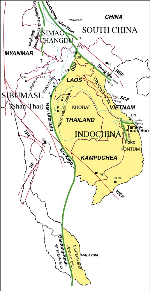
Indochina and surrounding crustal blocks involved in the Indosinian orogeny and the main suture zones (heavy green/grey lines); adapted from [27]. Arrows are related to Indosinian strike-slip movements. Tertiary to Quaternary faults are indicated by red/black lines. The approximate extension of the Khorat and Simao basins are indicated by fine dashed lines. DBF: Dien Bien Phu Fault; RF: Ranong Fault; RRF: Red River Fault; SCF: Song Ca Fault; TPF: Three Pagodas Fault; WCF: Wang Chao Fault. B: Bangkok, CM: Chang Mai, CR: Chang Rai, DB: Dien Bien, DN: Da Nang, H: Hanoi, HCM: Ho Chi Minh City, L: Loei, LP: Luang Prabang, N: Nan, P: Phetchabun, PP: Pnomh Penh, U: Uttaradit; V: Vientiane.
Fig. 1. L’Indochine et les blocs crustaux adjacents impliqués dans l’orogénèse indosinienne, que délimitent des zones de suture (en trait vert/gris épais) ; adapté d’après [27]. Les flèches indiquent les décrochements ductiles indosiniens. Les failles d’âge Tertiaire et Quaternaire sont indiquées par des traits rouges/noirs. L’extension approximative des bassins de Khorat et de Simao est indiquée par des pointillés. DBF : faille de Dien Bien Phu ; RF : faille de Ranong ; RRF : faille de la rivière Rouge ; SCF : faille de Song Ca ; TPF : faille des Trois-Pagodes ; WCF : faille de Wang Chao. B : Bangkok, CM : Chang Mai, CR : Chang Rai, DB : Dien Bien, DN : Da Nang, H : Hanoi, HCM : Ho Chi Minh City, L : Loei, LP : Luang Prabang, N : Nan, P : Phetchabun, PP : Pnomh Penh, U : Uttaradit ; V : Vientiane.
The tectonic structures in Vietnam resulted of two major collisional events that took place during the Permo-Triassic and the Tertiary. The former, related to the Indosinian event, has been defined by the unconformity of the Upper Triassic red beds [3,12,13,24], and is the consequence of the collision of Indochina with the adjacent Gondwana-derived blocks and island-arcs in between [1,27]. The latter is related to the India–Asia collision and the subsequent lateral extrusion of Indochina along the Red River fault [52].
In this paper, we present the main Indosinian tectonic structures that have been identified in Vietnam, focussing on the collisional zones of Song Ma and Po Ko. Structural and kinematic data are integrated into the various petrological and geochronological information that has been recently obtained in these two areas. Taking into account these different sources, we propose a geodynamic frame of Vietnam during the Indosinian period. The pre-Indosinian setting is tentatively considered.
2 Truong Son Belt and Song Ma Suture
2.1 General context
The structural grain of the elongated Truong Son Belt (previously known as Annamitic Cordillera), which developed in Central Vietnam and eastern Lao, is dominated by a system of subparallel northwest-trending strike-slip faults (Fig. 2), coinciding generally with mylonitized zones that display dextral shearing [26]. Rocks in the shear zones (Fig. 3) are metamorphosed up to the amphibolite facies grade, while deformation and metamorphism in the adjacent segments are relatively weak. This northwest-striking pattern is dissected by numerous submeridian faults. The Song Ma Zone is the northernmost shear zone. To the south, a system of subparallel shear zones, from Quang Ngai, Tra Bong and Tamky to Phuoc Son, marks the boundary with the Kontum Massif. In the central part of the Truong Son Belt, similar highly deformed ultramylonitic zones have been identified [26]: in particular, a complex array of ductile strike-slip faults developed from the North of the Khorat Basin in the Lao territory to the area of Quang Tri, Hué and Dailoc-Da Nang in Vietnam.
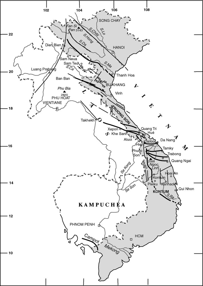
Major Indosinian shear and mylonitized zones in Vietnam (heavy solid lines): WNW-trending dextral system in the Truong Son belt and oblique-slip sinistral shear at the western border of the Kontum Massif (Po Ko shear zone). The Tertiary Bu Khang-Phu Hoat extensional dome, as well as other Tertiary and Quaternary faults, is mentioned; part of the Indosinian shear zones have been reactivated at that time (adapted from [27]).
Fig. 2. Principales zones de cisaillement mylonitiques d’âge Indosinien au Vietnam (trait épais) : système de décrochements ductiles dextres d’orientation ouest à nord-ouest dans la chaîne de Truong Son et oblique sénestre de Po Ko à la bordure occidentale du massif de Kontum. Le dôme extensif tertiaire de Bu Khang-Phu Hoat et les principales failles tertiaires et quaternaires sont mentionnés (adapté d’après [27]).
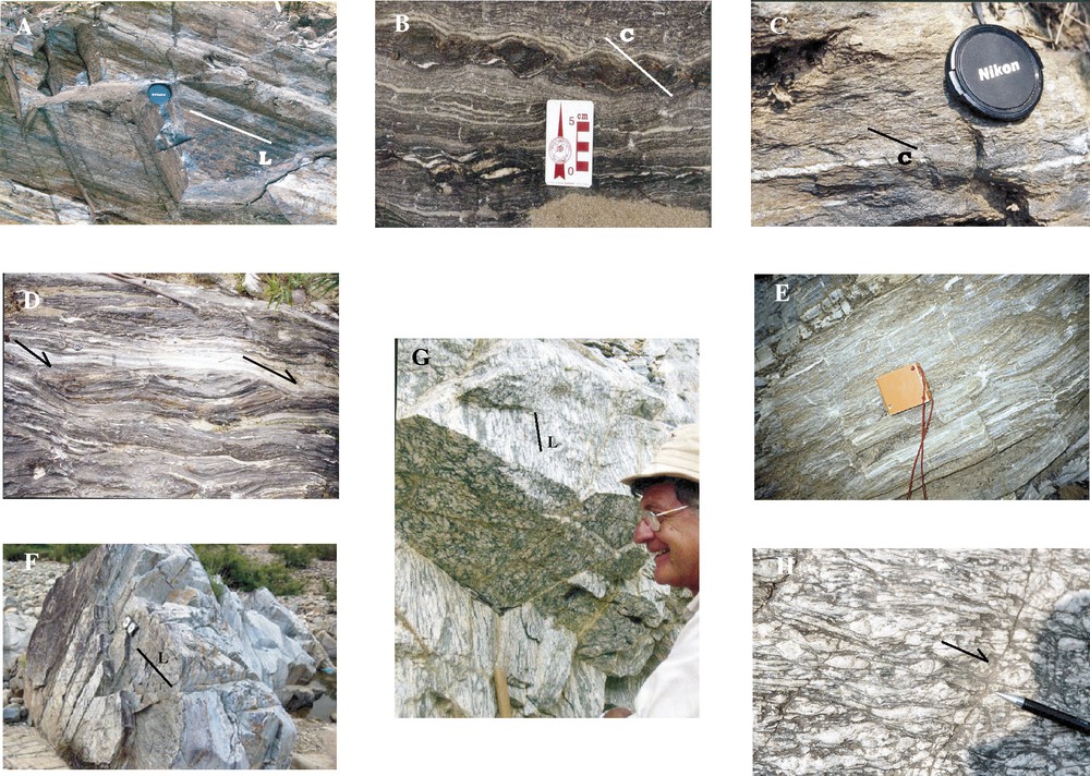
Field photos illustrating Indosinian microstructures and shear sense criteria in the Truong Son belt, from Song Ma to Quang Ngai-Phuoc Son (Kham Duc) shear zones. (A) N130 subvertical ultramylonites and 20°N-plunging lineation (Song Ma Formation, area of Chieng Khuong: 20°57′; 104°00′); (B) top view of asymmetric boudins and S-C dextral structures; Song Ma Formation, area of Quanh Hoa (20°22′45“; 104°57′30″); foliation is N125; 75S and the pitch of the stretching lineation is 8E; (C, D) top view of S-C dextral shear indicators; Song Ma zone, Quanh-Hoa-Song Luong area (same location as 3B); (E) north–south-stretching lineation and boudinage in Lower Devonian marbles and calcschists of the Nam Pia Formation (road from Tuan Giao to Dien Bien, Muong Ang area, 21°31′5; 103°12′); (F) gneissic ultramylonites in Trabong valley (15°16′; 102°29′): the foliation trend is N110, 60S and the pitch of the stretching lineation is E20; (G) L-type tectonite in orthogneiss near Phuoc Son (Kham Duc), 15°24′5, 107°46′; (H) top view of asymmetric K-feldspars and shear planes in orthogneiss from Quang Tri River; foliation is around N90–100 and subvertical, pitch of the lineation is 25E.
Fig. 3. Photos de terrain illustrant microstructures et figures de cisaillement dans la chaîne de Truong Son depuis Song Ma, au nord, jusqu’à la zone de Quang Ngai-Phuoc Son (Kham Duc), au sud. (A) Foliation subverticale de direction N130 et linéation plongeant à 20°N dans des ultramylonites (formation de Song Ma, secteur de Chieng Khuong, 20°57′ ; 104°00′ ; (B) vue du dessus de boudins asymétriques et de structures S-C dextres ; formation de Song Ma, secteur de Quanh Hoa (20°22′45“ ; 104°57′30″) ; la foliation est de direction N125, le pendage 75S et le pitch de la linéation d’étirement est 8E ; (C, D) critères S-C de cisaillement dextre (vue du dessus) dans la zone de Song Ma, secteur de Quanh Hoa-Song Luong (même localisation que 3E ; (E) linéation d’étirement nord–sud et boudinage dans les marbres et calcschistes du Dévonien inférieur de la formation Nam Pia (route de Tuan Giao à Dien Bien Phu, secteur de Muong Ang, 21°31′5 ; 103°12′) ; (F) gneiss ultramylonitique de la vallée de Trabong (15°16′ ; 102°29′) ; la foliation est de direction N110 et de pendage 60S, et le pitch de la linéation d’étirement est 20E ; (G) tectonite de type L dans un orthogneiss près de Phuoc Son (Kham Duc), 15°24′5, 107°46′ ; (H) vue du dessus de K-feldspaths étirés de façon dissymétrique et de plans de cisaillement dans les orthogneiss de la rivière Quang Tri ; la foliation est de direction N90–100 et subverticale, le pitch de la linéation est de 25E.
2.2 Song Ma and Song Da Zones
2.2.1 Tectonostratigraphic subdivisions
The Song Ma Zone [17,20,59] consists of several northwest-striking fault-bounded units (Fig. 4). Westwards, this zone and the associated Song Da Zone, which are bounded by the Song Da Fault, deflect clockwise as a result of the tertiary dextral motion of the Dien Bien Phu Fault.
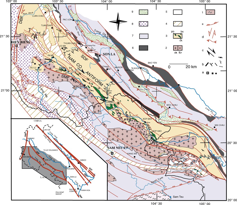
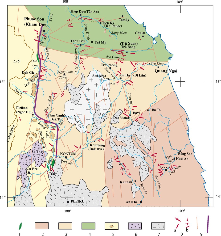
Simplified geological map of the Song Ma-Song Da area (Vietnamese and Lao territories), adapted from [27], after [4,5,17,18]. (1) Metamorphic formations (gneisses, micaschists, marbles) of the Bu Khang-Phu Hoat dome; (2) undeformed granite and granodiorite of Song Ma and Dien Bien Complexes (Triassic); (3) pelitic schists, Q-sericite schists, micaschists and quartzites of the Nam Co Formation (Late Proterozoic to Early Cambrian?) and sericitoschists and calcschists of the Song Ma and Ham Rong Formations (Cambrian to Lower Ordovician), which include as a tectonic melange various ophiolitic elements (pn: ultrabasites of the Pac Nam Complex; bx: metabasalts and diabases, amphibolites, gabbros and metagabbros of the Bo Xinh Complex; ck: plagiogranites of the Chieng Khuong or Posen Complex); (4) Upper Silurian and unconformable shales and carbonate sediments of the Lower Devonian Formation (Nam Pia Formation); (5) Middle Devonian to Carboniferous carbonate sediments (Da Mai or Bac Son and Ban Diet Formations); (6) Permian tuffs, felsic and mafic effusive rocks including komatiites (Yen Duyet, Cam Thuy and Vietnam Formations); (7) Lower Triassic terrigenous (Co Noi Formation) to Middle Triassic (Anisian-Ladinian) and Carnian mainly carbonate sediments; (8) Unconformable terrigenous and coal-bearing Norian-Rhetian sediments (Suoi Bang Formation); (9) Upper Cretaceous red beds of the Yen Chau Formation. (a) Localities; (b) Indosinian foliation, stretching lineation (heavy line) and lineation crenulation; (c) Indosinian dextral sense of shear; (d) Tertiary strike-slip and reverse faults; (e) Tertiary detachment fault (Bu Khang-Phu Hoat).
Fig. 4. Carte géologique simplifiée de la zone Song Ma-Song Da, Nord-Ouest du Vietnam et Laos, adapté de [27] d’après [4,5,17,18]. (1) Formations métamorphiques (gneiss, micaschistes, marbres) du dôme de Bu Khang-Phu Hoat ; (2) granite et granodiorite non déformés de Song Ma et Dien Bien (Trias moyen–supérieur) ; (3) schistes pélitiques, Q-séricitoschistes, micaschistes et quartzites de la formation Nam Co (Protérozoïque supérieur à Cambrien inférieur) ; séricitoschistes et calcschistes du Cambrien à l’Ordovicien (formations de Song Ma et Ham Rong), incluant tectoniquement des lentilles ophiolitiques (pn : ultrabasites du complexe de Pac Nam ; bx : métabasaltes, diabases, amphibolites, gabbros and métagabbros du complexe de Bo Xinh ; ck : plagiogranites du complexe de Chieng Khuong–Posen) ; (4) Silurien et niveaux discordants du Dévonien inférieur (formation de Nam Pia) ; (5) Dévonien moyen à Carbonifère carbonaté (formations Da Mai ou Bac Son et Ban Diet) ; (6) tufs volcaniques, laves mafiques et felsiques du Permien, incluant des niveaux de komatiites (formations de Yen Duyet11/29/2007, Cam Thuy et Vietnam) ; (7) Trias inférieur terrigène (formation Co Noi) et Trias moyen supérieur carbonaté (Anisien à Carnien) ; (8) sédiments terrigènes discordants du Norien–Rhétien (formation Suoi Bang) ; (9) couches rouges du Crétacé supérieur (formation de Yen Chau) ; (a) localités ; (b) foliation, linéation d’étirement (trait épais) et linéation de crénulation d’âge Indosinien ; (c) cisaillement dextre indosinien ; (d) failles tertiaires : décrochements et chevauchements ; (e) détachement tertiaire (Bu Khang Phu Hoat).
The axial unit of the Song Ma Zone is represented by metasediments of the Song Ma and Ham Rong Formations [4,5,54], assigned to the Cambrian–Lower Ordovician. It encloses tectonically sheared lenses of mafic to ultramafic rocks of ophiolitic nature, and accordingly it has been interpreted as the trace of an oceanic suture between Indochina and South China [14,20,26,27,51,60]. To the south, bounded by the Song Ma Fault, is exposed the undeformed Triassic Song Ma Granite, which intrudes laterally the metamorphic Su Lu Formation made of sillimanite–garnet micaschists and amphibolites. This intrusion and, more to the west, the equivalent Dien Bien Granitic Complex are unconformably covered by Upper Triassic (Norian) conglomerates and sandstones. The northern unit is made of different metamorphic formations which form a broad antiform, called the Song Ma anticlinorium [59]. The core of the antiform, crossed by the road from Son La City to Chieng Khuong, is occupied by the Late Proterozoic–Lower Cambrian Nam Co Formation [4,5,54], made of micaceous pelitic schists. Going to the west, the structure evolves into a system of NNW-trending antiforms and synforms separated by submeridian faults, which are crossed by the road from Thuan Chuan to Dien Bien through Tuan Giao and by the Nam Co River. In the area of Muong Ang, the axial part of a relatively flat and broad synform is occupied by the Devonian metamorphic, but still fossiliferous, Pa Ham Formation [5,54], containing corals.
North of the Song Ma zone, the Song Da zone is classically interpreted as a continental rift [20] that differentiated within a carbonate environment represented by the Early Permian Da Mai Formation. In the rift zone, the sedimentary succession is dominated by terrigenous facies rocks up to the Lower Triassic. Mafic effusive formations of Permian age (Yen Duyet, Cam Thuy and Vietnam Formations) [4,54] are interbedded in the series. In particular, komatiite rocks, equivalent to those known in South China (Emenshian volcanic province) and related to a mantle-plume activity, have been described in the area [19,46,47]. In the Middle Triassic, the sedimentation becomes calcareous, but involves interbeds of felsic Anisian calc-alkaline rocks (rhyolite, tuffs) of the Dong Trau Formation. Similar felsic rocks of the Song Da Formation, west of the Dien Bien Fault, could have been emplaced as soon as the Permian [54]. The Upper Triassic is represented by terrigenous formations. Such Upper Triassic clastics and also Cretaceous red sandstones that rest unconformably above schistosed epimetamorphic Middle Triassic formations demonstrate the influence of a late Indosinian episode of deformation in the Song Da Zone [24].
2.2.2 Petrologic and geochronologic data
In the Song Ma zone, petrologic evidence demonstrates that the Honvang serpentinic body, consisting of massive serpentinite with chromian spinel derived from lherzolitic harzburgite, altered gabbro of MORB-like affinity and some high Al-type chromitite, represents a remnant of palaeo-oceanic lithosphere [60]. The surrounding metamorphic rocks, which enclose the disrupted ophiolitic material, reach amphibolite facies, with muscovite, biotite, garnet, and sillimanite assemblages. Occurrences of HP mineral assemblages that had been suspected [17] were not confirmed until the recent discovery of relics of eclogite facies rocks enclosed within schists [36,37].
Extensive geochronological investigations by Ar–Ar method on synkinematic minerals from mylonites in the Nam Co and Song Ma Formations display ages of 240–250 Ma [26,29].
2.2.3 Structural and kinematic data (Figs. 3 and 4)
According to the descriptions by Findlay [14–16] for the Son La-Chieng Khuong and Co Ma sections of the Song Ma antiform, the tectonometamorphic evolution is polyphased, and includes the development of several planar and linear structures. S1 is related to a metamorphic layering, well expressed in orthogneisses and in metabasic rocks; in the metasediments, the dominant schistosity S2 overprints an earlier lithological/metamorphic quartz–mica layering (S1), developing axial planar to isoclinal microfolds. In turn, S1 and S2 fabrics are affected by a steep crenulation cleavage S3. The associated L3 lineation, as well as mesoscopic F3 folds that refold the previous foliations, corresponds to the general northwestern strike of the antiform. This map-scale structure therefore could appear as being formed during a late Indosinian tectonic stage.
Our investigations at the southern limb of the antiform have revealed the existence of steeply-dipping gneissic ultramylonites with subhorizontal stretching lineation. The accompanying asymmetrical criteria associated with stretching lineation consistently indicate a dextral sense of shear (Fig. 3A–D). This strike-slip shearing is corroborated by the occurrence of sheath folds and also by the development of steep-axe microfolds, as already mentioned [14]. In our interpretation, the arching is not the result of a superimposed episode of deformation, but is likely synchronous with the dextral shearing and the development of mylonites along the Song Ma suture, being related to the same dextral transpressional kinematics. Sheath folds, associated with the map-scale antiform, which were attributed to a D3 event by Findlay [14,15], are therefore more likely formed during an initial episode, synchronously with the dextral shearing. The north–south system of antiforms and synforms that develops west of Tuan Giao has been formed in the same way. In the axial part of the synform near Muong Ang, the Devonian marbles, associated with calcschists, exhibit a marked stretching lineation and boudinage structure that both indicate an axial transport to the NNW (Fig. 3E). At the eastern border of the synform, the Nam Co Fm and the intensively folded Devonian marbles overthrust the Permian lavas of the Song Da Zone through a ductile contact. As it is exposed in the upper course of Nam Muc River and north of Tuan Giao, these greenschist-facies aphanitic lavas are progressively sheared, as a result of Indosinian movements.
3 The Kontum Massif and the West-Kontum Po Ko Suture Zone
3.1 General context
The Kontum Massif, in South-Central Vietnam (Fig. 5) consists of a large uplifted area of mainly metamorphic and magmatic material. Preserved granulitic rocks have long been identified within the metamorphic rocks [8,45]. The magmatic formations are represented by variably deformed or undeformed granitic intrusions of Triassic age, including charnockitic rocks, and by volcanic to volcano-sedimentary Permian-Triassic rocks. Cretaceous granitic intrusions related to a Palaeopacific subduction are present in the coastal part of South-Central Vietnam. Sedimentary rocks are poorly represented. Quaternary basalts largely cover the massif forming the central highlands.
Schematic structural map of the Kontum massif, showing the distribution of the different metamorphic units with respect to the Po Ko suture zone and the measured foliations and linéations throughout the massif, after [6–11,18]. (1) Po Ko suture zone with disrupted ophiolitic elements of the Pleiweik Complex; (2) Kannack granulitic complex and related charnockitic intrusions and Pleimanko granitic complex; (3) Ngoc Linh amphibolite and granulitic facies complex (micaschists, gneiss, migmatites of the Tac Po and Song Ré Formations); (4) Kham Duc Barrowian-type metamorphism; (5) Dien Binh amphibolite facies complex including Ordovician granodioritic intrusions; (6) calc-alkaline Upper Permian–Lower Triassic volcanics and volcano-sedimentary material (Chu Prong Formation); the isolated outcrop of Devonian Cu Brei Formation is mentioned by a star; (7) Quaternary basalts; (8a) measured trends of stretching and/or mineral lineations; sense of shear is top-to-the-east along the north–south Po Ko Shear Zone and dextral along the east–west- to WNW-trending foliation (when observed dip-slip shear sense are indicated by arrows); (8b) measured trends of foliations planes (steep to low-angle dips are indicated by short to long bars); (9) Po Ko Suture Zone and main faults. Except in the Dien Binh, pre-Indosinian granitic intrusions more or less transformed into orthogneiss have not been distinguished. Post-Indosinian undeformed intrusions of Triassic and Cretaceous ages are not reported, except the Triassic granite, which occupies the core of the Ngoc Linh Complex.
Fig. 5. Carte structurale schématique du massif de Kontum, montrant la distribution des différentes unités métamorphiques par rapport à la zone de suture de Po Ko et les mesures de foliations et linéations relevées dans l’ensemble du massif, d’après [6–11,18]. (1) Zone de suture de Po Ko, avec les éléments ophiolitiques disjoints du complexe de Pleiweik ; (2) complexe granulitique de Kannack et intrusions granitiques (Pleimanko Complex) et charnockitiques associées ; (3) complexe amphibolitique et granulitique de Ngoc Linh (micaschistes, gneiss, migmatites des formations de Tac Po and Song Ré) ; (4) complexe métamorphique de type Barrovien de Kham Duc ; (5) complexe métamorphique de faciès amphibolite de Dien Binh, incluant des intrusions granodioritiques d’âge Ordovicien ; (6) matériel volcanique et volcano-sédimentaire calco-alcalin d’âge Per mien supérieur–Trias inférieur (formation de Chu Prong) ; l’affleurement isolé de Dévonien de la formation de Cu Brei est mentionné par une étoile ; (7) basaltes quaternaires ; (8a) directions mesurées de linéations d’étirement ; le sens de cisaillement est vers l’est, le long de la zone de cisaillement nord–sud de Po Ko et est dextre au long des foliations est–ouest à WNW (le sens des cisaillements normaux est indiqué par une flèche) ; (8b) directions mesurées de plans de foliation (les pendages forts à faibles sont indiqués par des barres courtes à longues) ; (9) zone de cisaillement de Po Ko et principales failles. Sauf dans le complexe de Dien Binh, les intrusions granitiques pré-indosiniennes transformées en orthogneiss n’ont pas été distinguées. Les intrusions non déformées post-indosiniennes d’âge Triasique ou Crétacé ne sont pas reportées, sauf l’intrusion granitique triasique qui occupe le cœur du complexe de Ngoc Linh.
3.2 Tectonic and petrologic subdivisions
3.2.1 Po Ko Fault Zone
The western part of the Kontum massif, at short distance from the Lao-Vietnamese boundary, is crossed by the major north–south-striking Po Ko Fault, which belongs, as the Dak To Kan Fault, to a system of submeridian faults that developed parallel to the Kontum continental margin. From Phuoc Son to the South of Pleikan, the steeply dipping Po Ko Fault coincides with the Dak Sé valley and, after the Loxo pass, with the upper course of the Krong Po Ko. South of Pleikan, the main fault splays into several secondary faults. More to the south, the trace disappears beneath the Quaternary Pleiku basalts plateau. To the north of Phuoc Son, the main fault is relayed by a set of subparallel fault segments, but the extension of the system is unclear.
In between Pleikan to Phuoc Son, recent fault scarps, abrupt reliefs, and other morphotectonic features attest to the recent activity of the Po Ko fault through normal and strike-slip movements. This is confirmed by the development of pseudotachylites and by the existence of uplifted Quaternary conglomerate deposits in a small graben formed at the emplacement of an overlapping zone at the Loxo pass.
On the major part of its length, the course of the Po Ko Fault coincides with a sheared palaeosuture zone, delineating contrasting terranes (Fig. 5). The suture is underlined by discontinuous outcrops of a variety of ophiolitic rocks that are referred to the Pleiweik Complex [6,7,54]. The age of this oceanic material remains unsettled yet, due to the absence of associated datable cherts and appropriate radiometric dating. The complex consists generally of elongated and sheared lenses of gabbros, pyroxenites, and peridotites that are partially amphibolized and serpentinized at their margins [58]. Good outcrops can be examined in the area of the Loxo pass and on the banks of the Yaly artificial lake, where gabbros and pyroxenites are exposed as rather massive layers or are intensively sheared as a result of strike-slip ductile movements (Fig. 6).
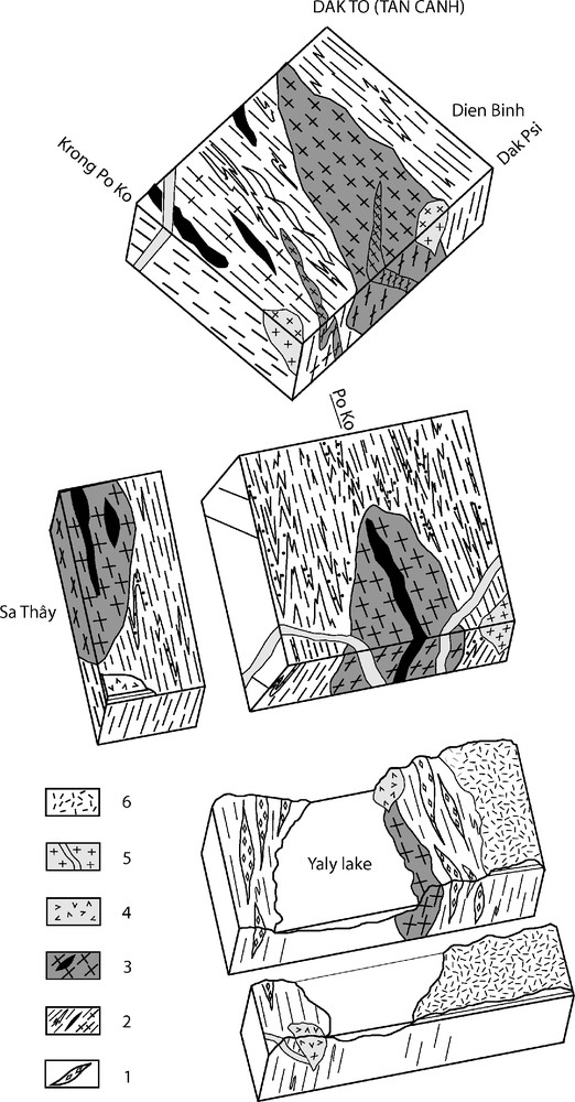
Series of three-dimensional diagrams of the western side of the Po Ko suture from Dakto to the Yaly dam, to show the field relations of the Dien Binh magmatic Complex. Not to scale. (1) Sheared ophiolitic material of the Pleiweik Complex: (amphibolitized pyroxenite, layered gabbros etc.); (2) host-rocks of the Dien Binh intrusions: Sa Thay metamorphic Formation (micaschist, paragneiss, quartzite, amphibolite); (3) Dien Binh intrusives: gneissified granodiorite bodies, amphibolite veins; (4) Permian–Triassic calc-alkaline volcanics (rhyolite, dacite…) of the Chu Prong Formation; (5) undeformed granitic bodies and cross-cutting aplitic veins (mid to Late Triassic?); (6) Quaternary basalts.
Fig. 6. Série de blocs diagrammes à la bordure occidentale de la suture de Po Ko, le long de la rivière Po Ko depuis Dakto jusqu’au barrage de Yaly, montrant les relations du complexe de Dien Binh avec les roches avoisinantes. Échelle non respectée. (1) Complexe ophiolitique déformé et cisaillé de Pleiwek : (gabbro et pyroxénite amphibolitisée, etc.) ; (2) formation encaissante métamorphique (complexe de Sa Thay) des orthogneiss de Dien Binh : micaschiste, paragneiss, quartzite, amphibolite ; (3) intrusions de Dien Binh : gneiss granodioritique, veines et filons d’amphibolite ; (4) laves calco-alcalines du Permo-Trias (rhyolite, dacite…) de la formation de Chu Prong ; (5) corps intrusifs de granite non déformé et veines tardives d’aplite (Trias moyen–supérieur ?) ; (6) basaltes quaternaires.
3.2.2 Dien Binh Complex
Rocks belonging to the magmatic and metamorphic Dien Binh Complex are distributed west of the Po Ko Suture (Figs. 5 and 6). The western extension of these terranes cannot be clarified, because they are largely intruded by granitic rocks or covered by Permian volcanic lavas or volcano-detritic Triassic sediments. More to the west, they disappear beneath the Mesozoic sedimentary strata of the Khorat Basin. In addition, this zone, which is close to the Cambodia-Lao-Vietnamese boundary, is a restricted area, quite difficult to be accessed for geological investigations. Good outcrops are provided by the new Ho Chi Minh road from the North of Pleikan (Ngoc Hoi) to Dak Gley, and by the banks of the Po Ko River in the vicinity of Dakto (nearby the ancient military landing stripe), nearby the Dien Binh village, along the Dak Psi River. Other good outcrops exist more to the west near Sathay, along Dak Sir.
The Dien Binh Complex [6,7,18,54] consists of amphibolite-facies igneous rocks, made of porphyroid granodioritic to dioritic bodies, fine-grained aplitic veins, and mafic layers or dykes. This magmatic material intrudes into foliated metasedimentary rocks, represented by paragneisses, sillimanite-bearing micaschists, and quartzites. A weak foliation, underlined by the planar arrangement of biotite, can be recognized in the magmatic intrusions (Fig. 7G), parallel to the foliation of the host rocks. The mafic parts, transformed into amphibolites, are stretched and boudinated, showing asymmetrical kinematic criteria (Fig. 7H). Regionally, the trace of the foliation swings from north–south to WNW–ESE in the segment comprised between Pleikan and Dakto, while the dip to the west and SSW is moderate to steep. A later generation of magmatic material, made of granite, aplitic veins and rhyolites, cuts through this complex, as evidenced by the field relations provided by various outcrops (Fig. 6). Unmetamorphosed dacitic lava flows, which belong to the Permian Chu Prong Formation, lie subhorizontally on the Complex, nearby the road to Sathay. Recently discovered Lower Devonian fossiliferous carbonate platform sediments of the Cu Brei Formation rest unconformably, through basal conglomerates, on the Dien Binh granitic material [55].
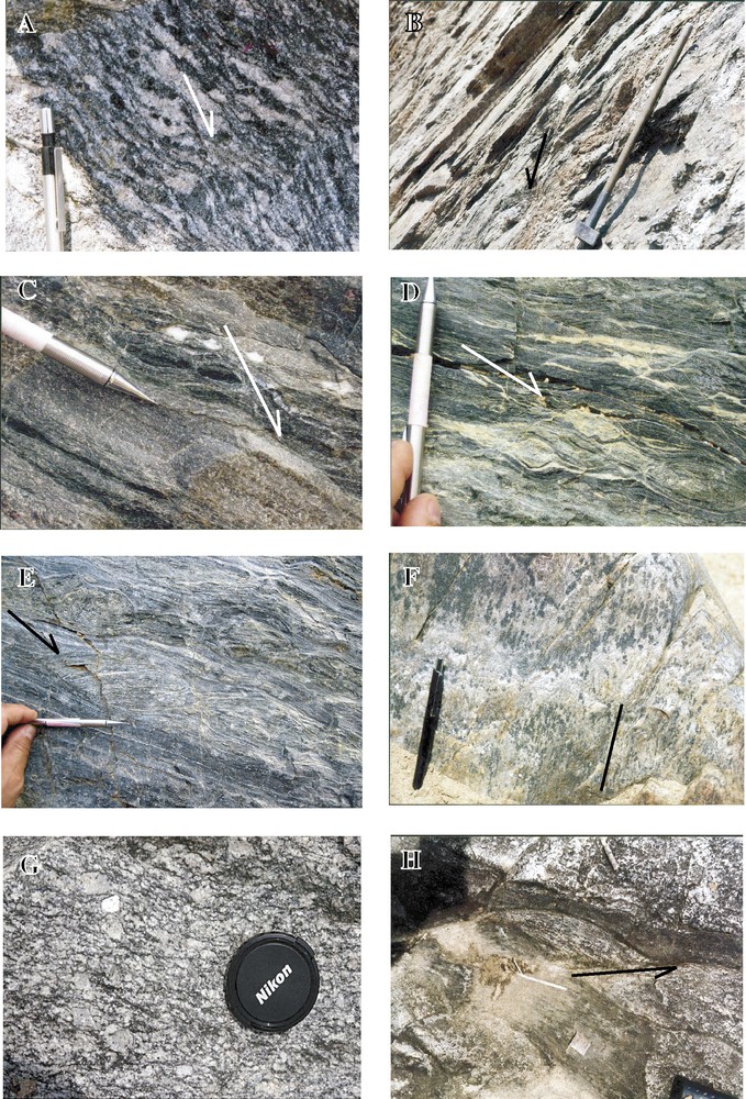
Field photos illustrating examples of normal sense of shear in the Kontum Massif (A to F) and microstructures in the Dien Binh Complex (G, H). (A) Normal C-S structure in the Ngoc Linh amphibole-bearing orthogneiss (Bavi-Violak area 14°46′5; 108°32′); (B) normal C-S shear structure in the micaschists of the Ngoc Linh Complex (Konplong area :14°28′5; 108°12′); (C, D and E) extension-related kinematic criteria expressed by dissymmetric nodules and boudins of olivine, in garnet amphibolites and skarns of the Pleiwek Complex (Po Ko shear zone, 15°22′and 107°45′5); foliation is approximately north–south and dips 40°W; (F) dip-slip normal lineation marked by stretched amphibole minerals in the granulite of Song Bien (Kannack Complex, Hoai An, 14°14′, 108°55′); (G) foliated granodioritic intrusion of the Dien Binh Complex (Dakto area, Po Ko river near the old military landing stripe of Dak To, 14°39′ and 107°47′5); foliation strikes N100 and dips 65S; (H) left-lateral shear sense in the surrounding micaschists (Dak Psi River west of Dien Binh village,14°36′5 and 107°51′).
Fig. 7. Photos d’affleurements illustrant des figures de cisaillement normal dans le massif de Kontum (A à F) et la déformation ductile dans le complexe de Dien Binh (G, H). (A) Structure C-S de cisaillement normal dans les orthogneiss à amphibole de Ngoc Linh (secteur de Bavi-col de Violak 14°46′5 ; 108°32′) ; (B) idem dans les micaschistes de Konplong (14°28′5 ; 108°12′) ; (C, D, E) critères de cisaillement normal, exprimés par des figures d’étirement dissymétrique d’olivine dans des amphibolites à grenats du complexe de Pleiweik (zone de cisaillement de Po Ko, 15°22′, 107°45′5) ; la foliation est nord–sud et le pendage 40°W en moyenne ; (F) linéation de sens normal marquée par des amphiboles dans les granulites de Song Bien (complexe de Kannack, Hoai An, 14°14′, 108°55′) ; (G) foliation (direction N100, pendage 65S) dans une intrusion granodioritique du complexe de Dien Binh (rivière Po Ko en bordure de l’ancienne piste d’aviation militaire de Dak To, 14°39′, 107°47′5) ; (H) cisaillement ductile sénestre dans les micaschistes et les niveaux d’amphibolite du complexe de Dien Binh (rivière Dak Psi, à l’ouest du village de Dien Binh, 14°36′5 et 107°51′).
3.2.3 Kannack and Ngoc Linh Complexes
East of the Po Ko Fault, metamorphic and related intrusive rocks of the Kannack and Ngoc Linh Complexes are exposed [18,45]. Recent petrological investigations have shown that both have experienced granulitic conditions up to ultra-high temperature metamorphism [35,38,41,42], before being partly retrogressed and migmatized. Conversely, the Kham Duc Complex, which developed north of the massif and is separated from the Ngoc Linh Complex by the Quang Ngai–Phuoc Son and Trabong shear zones [8], is only composed of epidote amphibolite and amphibolite facies rocks [18,45].
- • The Kannack Complex, in the southeastern part of the massif, is represented by various granulitic rocks and mineral assemblages, including primary or retrograde paragenesis [35,38,41,42,61]. The main rock types are foliated Al-rich pelitic to semi-pelitic banded gneisses (khondalitic and kinzigitic gneisses), and more massive felsic gneisses; mafic gneisses, quartzo-feldspathic and calc-silicate rocks occur as interlayers or lenses. Essentially represented in the Song Ba valley, the magmatic rocks of the Plei Man Ko Formation [9,10,18] consist of garnet-bearing granites and orthopyroxene-bearing granites equivalent to charnockites, with, in particular, enderbites and fine-grained gabbroic to noritic rocks [44]. According to the field relations, they intrude the host granulite-facies gneiss: either they parallelise or cut through the foliation, being themselves foliated or massive [27]. They appear as coeval intrusive rocks that could be derived respectively from pelitic and mafic granulites [44]. Both the granulites and charnockites have suffered partial melting, as shown by the development of anactectic leucosomes.
- • The Ngoc Linh Complex (Song Ré and Tac Po Formations), in the northern and northwestern part of the area, is mainly represented by amphibolite-facies rocks (garnet amphibolite, biotite-hornblende gneiss), which are locally extensively migmatized (as in the Song Ré area). Recently, eclogitic ultrahigh-temperature-facies mafic granulitic rocks, represented by blocks and lenses within mylonitized felsic gneisses [35,38], have been identified in the western Ngoc Linh Complex in the area of Poko and Dak To Khan.
3.3 Geochronological data
The Kontum massif was previously assigned to the Precambrian and the Proterozoic basement [18,20,23,39,40,45,56]. In the past fifteen years and until recently, it has been the subject of extensive geochronological investigations, with multimethod dating combining Ar–Ar and U–Pb techniques [1,25,28,30,33,57,61]. It has been demonstrated that the Kontum massif did not escape the influence of the thermotectonic Triassic event. Radiometric data in the range of 240–250 Ma are contemporaneous to the Indosinian ages obtained in the Truong Son Belt [28–30]. However, it has been also established that the Kontum massif yields pre-Indosinian ages, ranging within the 450–475-Ma time interval and corresponding to an Ordovician magmatic and metamorphic episode [28,50].
- • In the granulite Kannack Complex, the oldest ages are encountered in the eastern part, along the Song Bien River [11], displaying Ar–Ar Ti-biotite ages of 400–405 Ma [30] and U–Pb monazite ages of 465–470 Ma [50]. Such apparent discrepancy is explained by the different closure temperatures of the two systems. The monazite ages reflect the minimum age of the peak metamorphic conditions. By contrast, the granulite rocks cropping out in the Song Ba valley yield concordant Triassic ages. U–Pb monazite ages of 247 Ma have been recorded [50] similar to a SHRIMP age of 253 Ma [57], also similar to a CHIME age of 248 Ma [41]. They are in good agreement with the Ar–Ar ages obtained in the same transect, with an average age of 245 Ma (241 to 248 Ma) [30]. This narrow time interval is reflecting a rapid exhumation process. It is noteworthy that the various charnockitic rocks of Song Ba record equivalent Ar–Ar ages with an average of 242 Ma [28–30]. A combined dating on the same enderbite sample has, for example, provided a 243-Ma biotite Ar–Ar age, close to the U–Pb emplacement zircon age of 249 Ma [33], and this also implies a rapid cooling. Another slightly older SHRIMP zircon age of 258 Ma was obtained from the same area [1] and a CHIME age of 240–260 Ma from a granite in the Plei Man Ko Complex [41].
- • In the Ngoc Linh Complex, all the available U–Pb and Ar–Ar ages are Indosinian, except a Lower Palaeozoic U–Pb age of 436 Ma reported in the eastern part of the Complex [25]. The Indosinian ages are widespread and are close to those of the Po Ko shear zone [27,61]. There, the pelitic and enclosed mafic granulite yield Sm–Nd isochron ages of 240–247 Ma [37]. The granitic rocks, which occupy the central part of the structure, north of Konplong, yield significantly younger 214–207-Ma Ar–Ar ages [61].
- • In the Dien Binh Complex, located to the west of the Po Ko Suture, U–Pb zircon dating on a magmatic granodiorite intrusion yields a 450-Ma age emplacement [33]. Other equivalent magmatic intrusions in the same sector were dated at 425 Ma. This age is in agreement with the unconformity of the Lower Devonian Cu Brei Formation [31]. Ar–Ar biotite ages on the same sample record younger ages (340 Ma on the same sample, 380 and 425 Ma on equivalent material). These younger ages are explained by the distinct closure temperatures of the U–Pb and Ar–Ar systems. The absence of any Indosinian ages underlines the originality of the Complex.
3.4 Structural and kinematic data
The metamorphic rocks that compose the Kontum massif are mostly well-foliated material and display zones of intense synmetamorphic shearing and mylonitisation. Despite the two episodes of the granulitic facies rocks formation in the Kannack Complex and the pre-Indosinian age of the Dien Binh Complex, no distinct superimposed foliations can be deciphered in the field, except the development of crenulation cleavage in some lithologies. Similarly, the retrograde mineral assemblages do not define a new foliation.
In the Kannack and Ngoc Linh Complexes, the foliation, then regarded as being formed during the Indosinian, according to the Ar–Ar age of synkinematic minerals, is generally variably striking. However, and in spite of scattered and discontinuous outcrops, the trace of the foliation defines dominating trends at map scale (Fig. 5), remaining almost constant in zones corresponding to intense shearing and mylonitisation.
- • In the vicinity of the Po Ko Fault, a prominent and regular north–south-striking foliation characterizes the differently deformed rocks, which exhibit a systematic westerly dip, moderate between Phuoc Son and Pleikan, at the western limb of the Ngoc Linh Complex, steep to subvertical in the southern segment around Kontum and the Yaly Lake. Only in the intermediate segment Pleikan to Dakto (Tanh Canh), the strike of the foliation measured in the Dien Binh unit turns to the WNW and dips to the southwest. The eastern border of the Ngoc Linh Complex exhibits the same submeridian strike of the foliation, but with an easterly dip, as it can be observed along the road from Ba Vi in the Song Ré valley (west of Ba To) to Kontum City through the Violak pass.
- • A remarkable east–west to WSW trend of the foliation, similar to that observed more to the north in the Truong Son Belt, corresponds to the Quang Ngai-Phuoc Son and Trabong shear zones, at the northern boundary of the Ngoc Linh Complex.
- • Within the Kontum Massif, a northeast- to ENE (N50-N60)-striking foliation can be recognized (Fig. 5), mainly in the southeastern and northern zones of the Ngoc Linh Complex. In the northern part, this trend, with a northwest dip, characterizes the area of Son Ha (Di Lân) to Quang Ngai, and more to the west the same can be observed south of Tramy, along Nam Num and the zone of Tu Mo Rong. This northeast-trending foliation is abruptly intersected by the N100 shear zone from Quang Ngai to Kham Duc (Phuoc Son). In the southeastern part, the approximately same trend with a southeastern dip is observed in the area of Konplong and southwest of Ba To, marking the boundary with the Kannack Complex to the southeast, which therefore overlies the Ngoc Linh Complex.
Whatever the attitude of the foliation and whatever the material concerned, the stretching/mineral lineation, as defined by elongated K-feldspars, stretched prismatic sillimanite and hornblende, by the oval shape garnets or cordierite, is nearly constant throughout the Kontum massif, in the Kannack and Ngoc Linh Complexes, as well (Fig. 5). Spectacular L-tectonites are exposed in orthogneissic rocks along the Quang-Ngai-Phuoc Son shear zone (Fig. 3G). The instantaneous strain pattern is coherent at the regional scale. The mean convergent direction is WNW to northwest (280–320), strictly comparable to the direction measured in the Truong Son Belt. Kinematic indicators associated with stretching lineation along the N90–110 Quang Ngai-Phuoc Son and in the Trabong and Tien Phuoc shear zones, more to the north, clearly display a dextral sense of shearing, as along similar zones in the Truong Son belt more to the north. In the Po Ko Shear Zone (north–south fabric), asymmetrical criteria reveal a top-to-the-east sense of shear, indicating reverse movements with a significant left-lateral component. Along the WNW-trending segment from Pleikan to Dakto, the stretching lineation is sub-horizontal and, in addition to the shear-sense indicators deduced from various asymmetrical criteria, the strike-slip dominating component is also suggested by microfolds with steep fold axes.
On the other hand, in some parts of the Kontum Massif, a normal sense of shear is clearly observed (Fig. 7A–F), indicating approximately the same NW–SE direction of extension. It can be correlated with the retrograde evolution and the exhumation of the basement. Observations of this nature have been made:
- • in the Son Ha to Quang Ngai area, where the Ngoc Linh complex is intersected by the Quang Ngai Shear Zone, and along the Konplong and Ba To, where the Ngoc Linh rocks plunge beneath the Kannack granulites, a correlated crenulation cleavage can be observed locally around Konplong. It therefore appears that the northeastern part of the Ngoc Linh Complex displays, along a NW–SE section, a global antiform geometry, likely related to an extensional process. Anatexis and emplacement of a granitic massif in the core of the complex are probably associated with that extension;
- • along the Song Ré River, well-exposed amphibolite gneisses show normal shear bands (Fig. 7A), because of an east–west extension. A late episode of brittle faulting affects the same rocks, which are progressively downthrown by a set of normal faults. Along the Po Ko Shear Zone, the west-dipping foliated and sheared rocks also provide examples of normal shear sense, marked by asymmetric lenses, and boudins of more resistant material (Fig. 7C–E).
Although being fragmented, the observed normal shear criteria point to a general phase of extension, which is responsible for the exhumation of the deep-seated rocks, including the HP metamorphic rocks located along the Po Ko Fault.
4 Indosinian geodynamic setting in Vietnam: a pair of opposite subduction-collision zones
4.1 Pre-Indosinian evolution
4.1.1 The question of a Caledonian tectonic event in Vietnam?
The so-called Caledonian Orogeny, although this name is inappropriate to be applied to Asia, has affected different parts of China, and in particular the South China block [2]. In Vietnam, the existence of a Lower Palaeozoic tectonic event is not clearly established. Ordovician ages of 465–470 Ma characterize the former HT granulitic episode in the eastern Kontum Massif. In western Kontum, on the western side of the Po Ko Suture, crystallisation ages of 400 to 450 Ma are displayed by the granodioritic intrusions of the Dien Binh Complex [33,61]. Similar protolith ages of 418–407 Ma have been reported from the Indosinian orthogneiss of the Dailoc Massif, west of Da Nang [1], and a 428-Ma crystallisation age is recorded by the orthogneiss of the Song Chay Massif, in North Vietnam [49]. It is highly probable that such a magmatic event is largely distributed throughout Vietnam, being the equivalent of the magmatic intrusions that are well known in the South China Block [62].
Devonian formations, which are exposed in northern Vietnam and north-central Vietnam, and further south in south-central Vietnam as an isolated outcrop over the western Dien Binh unit of the Kontum Massif [55], rest unconformably on older rocks. Whatever their facies, the Lower Devonian deposits, as it is clearly mentioned in the description of the stratigraphic units of Vietnam [54], exhibit a general basal unconformable contact. Only in some areas, they are in continuity with the Upper Silurian. Although further investigations are needed, such a relationship suggests that Indochina, as South China, has been subjected to the ‘Caledonian’ orogenic event.
The Devonian succession is itself variably deformed. Either, the Devonian rocks are highly deformed when they were involved in the Indosinian shear zones of the Truong Son Belt, as for example in the Song Ma Zone, or they are preserved from intense deformation and only slightly folded and almost unmetamorphosed within the segments comprised between the shear zones.
4.1.2 Rifting and opening of Palaeotethyan oceanic branches
The Lower Devonian succession, in the eastern zone of Vietnam, north and south of the Song Ma Suture and in South China, displays similar red facies and contains the same Vertebrate fauna [21,22,48,53,63]. Westwards, the terrigenous to near-shore facies evolves progressively into mixed and carbonate-platform marine environments. These similarities imply biogeographical land connection between the Indochina and South China blocks, and therefore the absence of any oceanic barrier at that period of time. Accordingly, this means that Indochina and South China were parts of the same landmass as soon as the Late Silurian [21,22,48,53,63]. If any older oceanic gap would have already existed along Song Ma, the connection of the two previously distinct blocks could likely be the result of a ‘Caledonian’ tectonic event. A further separation of Indochina and South China by oceanic opening of a Palaeotethyan branch along Song Ma could then only be established after the Devonian. Upwards within the Devonian succession, from the uppermost Lower Devonian, marine conditions were progressively generalized. As already suggested, the development of endemic forms at that time could be due to block-faulting and the differentiation of a broad rift [22], which possibly continued to develop into an oceanic basin.
4.2 Subduction of Indochina beneath South China along Song Ma
The Song Ma Zone has been regarded as a subduction zone [20,50,59] and was thought to represent either a Triassic or a pre-Devonian plate boundary between Indochina and South China. A pre-Devonian collision cannot be ruled out [16], but until now is not substantiated by reliable geochronological arguments. Instead, the Lower Triassic 250–240-Ma Ar–Ar ages, which have been obtained in the Song Ma Zone [26], have largely established the role of the Indosinian thermotectonic event, and the recent discovery of HP Indosinian metamorphism provides critical evidence for subduction of continental crust [34,36,37]. This process could have followed an oceanic subduction. Preference has been given to a north-dipping oceanic subduction of Indochina beneath South China [27] by considering the spatial distribution of effusive rocks of Permian age that have developed in the Song Da Zone. However, the description of these Permian volcanics does not suggest any volcanic arc setting, except those of the Song Da Formation, but instead indicates that they are genetically rift-related [46,47]. It is therefore not obvious that the Indosinian oblique collision/continental subduction along Song Ma was subsequent to an oceanic subduction. Further evidence is requested and first of all the age of the oceanic material in the Song Ma suture is a critical point for supporting or not the hypothesis.
4.3 West-dipping subduction and collision of Indochina (Kontum Block) along the Po Ko Shear Zone
4.3.1 Metamorphic-grade distribution and P–T conditions
The distribution of the metamorphic rocks throughout the Kontum Massif show significant variations from east to west and from north to south, according to their metamorphic grade.
The highest-grade granulite-facies metamorphism is restricted to the western Kannack and Ngoc Linh Complexes with thermobarometric estimates of 900–990 °C and 1.03–1.50 GPa [35,37,41–43]. Eclogitic (1.8 GPa) ultrahigh-temperature conditions are recorded in mafic granulites, as part of a prograde metamorphism [35]. In the eastern Kannack and Ngoc Linh area, estimated P–T conditions, corresponding to granulite- to amphibolite-facies metamorphism, correspond to medium to high temperatures and low pressures (700–900 °C and 0.50 to 0.84 GPa), with temperature decrease in the northeast. In the northern Kham Duc Complex, mineral assemblages, which correspond to an amphibolite- to epidote amphibolite-facies metamorphism, indicate low to medium temperatures and moderate to high pressures [38].
The highest grade UHT and HP metamorphic rocks in western Kannack and Ngoc Linh Complexes show a similar clockwise P–T path [35,38,42], with a near-isothermal decompression following the peak metamorphism and a final near-isobaric cooling. A comparable clockwise shape is displayed by the Kham Duc Complex [37]. Retrograde conditions variably affect the massif. Primary assemblages are either well preserved, while in other areas they are replaced by a secondary paragenesis that could be the result of a low-grade superimposed event [30].
4.3.2 Geochronological constraints
Geochronological data, obtained by various methods on granulite-facies rocks collected throughout the Kannack and Ngoc Linh Complexes, have revealed the existence of two age groups, corresponding to two episodes of HT metamorphism [50]. All the charnockitic rocks of the Song Ba area yield Triassic ages. The older Lower Palaeozoic granulitic-facies ages characterize the eastern part of the Kannack Complex, whereas Triassic ages are restricted to the Song Ba area in the central and eastern parts of the Ngoc Link Complex, close to the Po Ko Suture Zone.
In the Dien Binh Complex, U–Pb dating on the magmatic intrusions also indicates Ordovician–Silurian ages, while the Ar–Ar method provides younger, but non-Indosinian ages, on the same rocks. These ages have been interpreted as differential cooling ages. A partial reset, due to a later thermal overprint that could be relevant to an Indosinian event is unlikely, as has been discussed [33]. A speculated distinct intermediate event has been inferred, but until now has not been documented elsewhere in Indochina.
4.3.3 Interpretation
Whereas the U–Pb and Ar–Ar Ordovician–Silurian ages reflect the climax of the original granulite facies metamorphism, the second age group is related to the Indosinian overprint resulting in a partial or total reset. In eastern Kannack, the granulite-facies rocks yield a preserved Ordovician–Silurian age. The total metamorphic resetting of the primary HT granulitic event by the Indosinian thermal event can be explained, in the central Song Ba part of the Kannack Complex, by the huge amount of the Triassic charnockitic intrusions, providing a sufficient reheating [50]. Conversely, the Indosinian high-grade granulitic conditions recorded in the Ngoc Linh Complex, east of the Po Ko Suture, require another explanation, within a collisional setting zone [38,42]. Taking into account the structural and kinematic data collected in this suture zone, together with the distribution of ages and metamorphic grade in the granulite-facies rocks, a west-dipping subduction along the Po Ko suture and a subsequent collision provide the needed HP conditions. Although the oceanic material of the suture has not been dated, Triassic ages found for the high-pressure granulite metamorphism [38] are in favour of a westward subduction process of a branch of the Palaeotethys, leading to continental subduction and suturing in the Early Triassic [27].
This interpretation is corroborated by the emplacement of granitic intrusions and effusive rocks along the Po Ko Zone, on the western Dien Binh side. The Late Carboniferous–Early Permian volcano-sedimentary Dak Lin Formation, including dacite, andesite, and basaltic tholeiitic lavas, crops out in the Northwest of the city of Buon Ma Thuot. Similarly calc-alkaline rocks (tuffs, rhyolite, dacite and andesite) of the Chu Prong Formation, referred to the Upper Permian–Lower Triassic, are exposed in the area of Plei Ku and Sa Thay (Figs. 5 and 6), and are related to a volcanic-arc environment. Part of these subduction-related rocks corresponds to pre- or syn-collisional emplacement, and is consequently deformed. Some other bodies of granite and effusives are undeformed, cutting through the Indosinian foliated rocks: they correspond to a postcollisional setting. A granitic intrusion of 204-Ma age marks the upper limit of the shearing age along the Po Ko zone [27]. Along the Quang Ngai shear zone, to the north, the shearing was completed by 222 Ma, as documented by a crosscutting granitic intrusion (coordinates:15° 09′; 108° 42′) [61].
This geodynamic setting also explains why the Dien Binh Complex, located in the upper plate, displays preserved pre-Indosinian ages.
5 Conclusions
The same northwest-striking stretching lineation pattern is observed in the Truong Son Belt and Kontum Massif of Vietnam, implying that Indochina moved as a single block during the convergent subduction–collision period. It is tentatively suggested that the Indochina microplate was comprised, during the Upper Palaeozoic, between a pair of opposite-vergence subduction zones, with active margins formed by the overriding of South-China and West Indochina (Khorat) microplates (Fig. 8). On the Khorat margin, subduction-related effusives were emplaced during the Upper Carboniferous and Permian. North of the Song Ma Suture Zone, on the South China block, the Permian basalts could have been emplaced in a back-arc setting, but the inferred calc-alkaline magmatic arc of that age is not enough documented. The calc-alkaline rocks that were emplaced later during the Triassic seem to be related to collision. The existence of an oceanic subduction is therefore questionable. The main thermotectonic event occurred simultaneously during the subsequent collision, during the Lower Triassic, as shown by various and numerous geochronological data. HP rocks, up to granulite facies, were generated contemporaneously in the Song Ma and Po Ko zones during this process [34,36–38]. In the Kontum Massif, the Indosinian HP granulites were formed within the Po Ko collisional zone by reworking of primary granulite rocks related to a first Ordovician episode, before being rapidly exhumed. Related extensional movements resulted in the formation of dome-like structures. Along the Song Ma Suture Zone, the oblique collision, within a transpressional setting, resulted in the development of a set of subparallel dextral shear zones within the Truong Son Belt. The segments between the high strain zones are weakly deformed. It is suggested that the localization of these high-strain zones was influenced by previous rift-related faults.
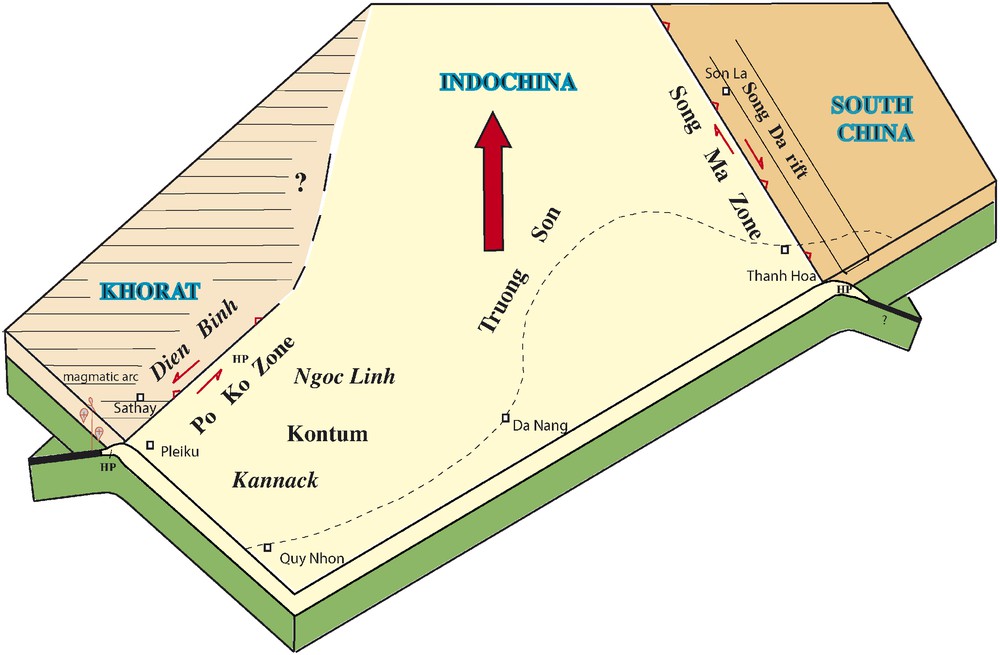
Hypothetical schematic plate-tectonic configuration in the Late Permian–Early Triassic Indosinian period showing the pair of subduction zones with opposite vergence along Song Ma and Po Ko, at the boundaries of Indochina.
Fig. 8. Schéma hypothétique du système de plaques à la fin du Permien et au début du Trias, montrant la double subduction indosinienne, à vergences opposées, du bloc Indochinois.
Acknowledgements
Fieldwork has been supported by CNRS (France). Claude Lepvrier is indebted to Laurent Jolivet and Philippe Huchon for a financial support from the Laboratory of Tectonics (UMR7072) of the Pierre-et-Marie-Curie University. We thank the Vietnamese authorities to have allowed and facilitated our displacements in the field. The reviews of Klaus Wemmer and Jacques Charvet have greatly allowed the improvement of this manuscript.