

1 Introduction
During the past decades, several studies have approached the Holocene sea-level variations along the French Atlantic Coast [14,16,19]. Focusing on the central Atlantic coast of France, onshore studies, based on both lithological and faunal assemblage analysis, have allowed the establishment of local sea-level curves during the Late Holocene [6,9,12,19]. Offshore studies have shown that both the bathymetry and the stratigraphy are controlled by the last sea-level drop [1,2,7,20,21]; nevertheless, accurate sea-level indicators have not been yet highlighted. Thanks to an unusual approach including seismic and sedimentary successions and mollusc death assemblages, this study aims at showing, for the first time in shallow-water environments of the central French Atlantic coast, Holocene sea-level indicators. The study area is located within the Marennes-Oléron Bay.
2 General settings
The Marennes-Oléron Bay is located on the Atlantic coast of France, immediately northward of the Gironde Estuary (Fig. 1a). This coast belongs to the passive continental margin of the Bay of Biscay, which was associated with moderate vertical crustal motions during the Holocene [14]. The Marennes-Oléron Bay is a wide semi-enclosed macrotidal environment connected to the Atlantic Ocean through the Pertuis d’Antioche to the north, and the Maumusson inlet to the south (Fig. 1b). Intertidal areas represent 60% of the bay and mainly consist of bare mudflats and Zostera noltii seagrass beds on the eastern and western sides [17]. Two small rivers flow into the Marennes-Oléron Bay: the Charente and the Seudre Rivers (Fig. 1b and c). Tides affecting the study area are semi-diurnal and range from less than 2 m (neap tides) to more that 6 m (spring tides). Swells are strongly attenuated by the narrow entrances of the bay, but wind waves can produce high turbidity in the water column due to wind-driven resuspension.

Location maps of the study area (NTF geodetic system, Lambert II e., coordinate in metres). (a) Map of France showing the study area. (b) Bathymetric map of the study area with bathymetric intervals of 2 m. (c) Simplified bathymetric map, showing VHR seismic tracks and location of the core VC48. M4b38 seismic profile is in bold. Boundaries of a former tidal channel (seismic unit U3 in Fig. 2) correspond to dashed lines.
Fig. 1. Localisation générale de la zone d’étude (système géodésique NTF, Lambert II e., coordonnées en mètres). (a) Carte de la France, montrant la zone d’étude. (b) Carte bathymétrique de la zone d’étude, avec des intervalles de contours bathymétriques de 2 m. (c) Carte bathymétrique simplifiée, montrant les routes sismique THR et la localisation de la carotte VC48. Le profil sismique M4b38 est en gras. Les limites du paléochenal tidal (unité sismique U3 dans la Fig. 2) sont en pointillés.
The flooding of the studied area during the last sea-level drop is characterized by a gradual rise to the present level, with a deceleration during the last 7500 yr B.P. [19] or 6000 yr B.P. [14]. Previous very high resolution seismic studies of both the north Marennes-Oléron Bay [4,8] and surrounding areas [3,7,20,21] have shown the control of recent sea-level changes on the detailed stratigraphy of drowned valley-fills. Those studies have evidenced that the northwestern Marennes-Oléron Bay sedimentary fill includes four units: the basal unit has been dated back to 6105 ± 35 yr B.P. and the uppermost one to 840 ± 40 yr B.P. [4,8]. On land, i.e. the Poitevin and Rochefort marshes, the imprint of the last sea-level drop has also been evidenced, and transition from marine to terrestrial habitats has been accurately described by faunal analyses [6,12].
3 Methodology
3.1 Seismic survey
Seismic data were collected during two cruises (April 2003, INSU Côte d’Aquitaine vessel and January–March 2005, Les Deux Mouettes vessel). Those very high resolution seismic surveys of the Marennes-Oléron Bay consisted of 135 profiles with a grid spacing <700 m (Fig. 1c). A Boomer source associated with a line-in-cone receiver (25-cm vertical resolution, [18]) was used to investigate this very shallow water study area. Positioning of seismic profiles was provided using a differential GPS navigational system. Processing of seismic data using Seismic Unix includes:
- • swell filtering;
- • frequency band pass filtering;
- • amplitude-attenuation correction by applying an exponential automatic gain control.
The selected seismic profile M4b38 was representative of the sedimentary infill of the eastern part of the Marennes-Oléron Bay (Fig. 1c).
3.2 Vibracore sampling and laboratory analysis
During MOBIDYC5 cruise (June 2006, INSU Côte de la Manche vessel), 56 vibracores were collected. The VC48 vibracore (425 cm long), collected along the seismic profile M4b38 (Fig. 1c), was selected with a view to ground-thrusting the seismic units of the eastern part of the Marennes-Oléron Bay. This core was transversally opened, described, photographed, X-radiographied (SCOPIX, [15]), and sampled for grain-size and mollusc death assemblage analyses. Sampling for grain-size analysis was selective, in that samples were collected only where X-ray images and grey-level curves showed noticeable changes. Grain size of the sediment samples was measured with a microgranulometer (Mastersizer S instrument, Malvern Instruments). Inman's classification was used to define the various grain-size fractions: clays and fine silts (<15 μm), medium silts (15–30 μm), coarse silts (30–63 μm) and very fine sands (>63 μm). Elevation data are given according to the NGF system (Nivellement Général de la France), the reference 0 m NGF being the mean tidal level at Marseille.
A P-wave velocity interval of 1580–1720 m s–1 was chosen for correlation between the core and the seismic profile, according to the relationship between P-wave velocity and the 30-μm mean grain size of the sampled sediment [13].
3.3 Mollusc death assemblages and 14C dating
The mollusc death-assemblage analyses were used to define the palaeoenvironment of the study area. The mollusc death assemblage was recovered from 26 bulk samples collected at 5-to-30-cm intervals when visible or revealed by X-ray images. Bulk samples were carefully water-sieved through a 500-μm mesh. Molluscs were sorted and counted under a binocular microscope, and identified at a species level where possible. Species names are in accordance with the ERMS nomenclature [10]. The radiochronology is based on three radiocarbon uncalibrated dating shells, carried out by AMS method in the Poznan Radiocarbon Laboratory, Poland. Samples were intact thin shells of the bivalves Abra alba (W. Wood, 1802) (Poz-20250) and Scrobicularia plana (da Costa, 1778) (Poz-20099). The probability that such fragile yet intact shells were transported or reworked is very low. When intact fragile shells could not be found in the samples, the most intact shell of another bivalve was chosen, i.e. Loripes lacteus (L., 1758) (Poz-20100).
4 Results
4.1 Seismic results
Seismic profile M4b38 recorded in the eastern part of the Marennes-Oléron Bay evidences two bounding surfaces and three main seismic units overlying the Mesozoic bedrock (U0) upper boundary EU0 (Fig. 2). From base to top, the bounding surfaces are labelled EU01 and EU1 and consist respectively in local and regional (EU1 in [4,7,8] and R4 in [20]) flat erosional unconformities. Surfaces EU01 and EU1 are both characterized by toplap terminations below and downlap terminations above.

VHR seismic profile M4b38 and its interpretation, showing the geometry of the sediment infilling of the eastern Marennes-Oléron Bay. Location of the core VC48 is indicated. Seismic unit U0 corresponds to the bedrock, and seismic units U1.1, U1.2, U3, U4.1, and U4.2 correspond to the soft sediment incised valley-fill.
Fig. 2. Profil sismique THR M4b38 et son interprétation, montrant la géométrie du remplissage sédimentaire de la partie orientale de la baie de Marennes-Oléron. La position de la carotte VC48 est indiquée. L’unité sismique U0 correspond au socle rocheux et les unités sismiques U1.1, U1.2, U3, U4.1 et U4.2 correspondent au remplissage sédimentaire de la vallée incisée.
From base to top, the seismic units are labelled U1, U3, and U4 (seismic unit U2, which was already described in previous studies as UT2 in [4,7] and Uaid2 in [7], does not appear in the eastern part of the Marennes-Oléron Bay). Seismic unit U1 is a valley-fill and includes two sub-units (U1.1 and U1.2) bounded by surface EU01. The upper boundary of both U1.2 and U3 is surface EU1. Seismic unit U4 was already characterized in previous studies and corresponds to UT4 in [4,8] and Uaid4sd in [7]. It is a sheet drape consisting of two seismic facies units (U4.1 and U4.2) conformably lying over each other and separated by a middle-to-high-amplitude sub-horizontal reflector. The detail stratigraphic succession is described as follows:
- • unit U1.1 consists of a valley-fill, onlapping upon the incised Mesozoic bedrock (U0). Its thickness varies from 2 to 5 m (Fig. 2). The seismic facies is characterized by low-amplitude reflectors. Internal geometry consists of a divergent valley-fill;
- • unit U1.2 consists of a valley-fill, lying over U1.1 and onlapping U0. Its thickness varies from 1.5 to 4.5 m. The seismic facies is characterized by low-to-middle-amplitude reflectors. The internal geometry consists of gently undulating and sub-parallel reflectors;
- • unit U3 consists of a concave upward shape cutting U1.1 and U1.2. Its maximum thickness is about 8 m. It corresponds to a channel fill whose boundaries are indicated in Fig. 1c. The seismic facies is characterized by high-frequency, middle-to-high-amplitude reflectors. The internal geometry is a complex channel-fill, including, from base to top, a divergent fill geometry, undulating reflectors and northward progradational reflectors;
- • unit U4.1 consists of a sheet drape, lying over U1.2 and U3. Its thickness varies from less than 1 m to about 1.5 m. The seismic facies is characterized by middle-to-high-amplitude reflectors. The internal geometry consists of sub-horizontal and sub-parallel reflectors;
- • unit U4.2 consists of a sheet drape, lying conformably over U4.1. Its thickness varies from less than 1 m to about 1.5 m. The seismic facies is characterized by low-to-middle-amplitude reflectors. The internal geometry consists of sub-horizontal and parallel reflectors.
4.2 Seismic units, sedimentology and mollusc death assemblages
Core VC48, cutting seismic units U4.2, U4.1 and U1.2, is composed of 62% of clays to fine silts (<15 μm), 24% of medium to coarse silts (15–63 μm) and 14% of very fine sands (63–125 μm). The core evidences a coarsening upward from −11.25 m NGF to −8.5 m NGF (Fig. 3) and a fining upward from −8.5 m NGF to −7 m NGF (seafloor). Grain-size populations are bimodal. The predominant mode varies from 50 to 100 μm and the secondary one varies from 5 to 7 μm. A total of 35 species are identified, and these include 17 bivalves, 17 gastropods and one scaphopod. Among them, 15 species are rare and represent less than 0.05% of total assemblage. The 21 most common species include nine subtidal species (two living on rocky and seven on muddy bottoms) and 12 intertidal species (five living on rocky shores and seven on mudflats). In general, the shells are well preserved.

Detailed description of core VC48. From left to right: elevation in metres (NGF), seismic units, X-ray image, grey-level curve, grain size, median grain size in micrometres, biofacies, biosamples, mollusc presence-absence matrix (R: rocky-shore species, S: soft-bottom species), 14C uncalibrated dates, sedimentary facies label and inferred palaeodepth. VC48 core location is shown in Fig. 1. Correlation between VC48 and M4b38 seismic profile is shown in Fig. 2.
Fig. 3. Description détaillée de la carotte VC48. De la gauche vers la droite : altitude en mètres (NGF), unités sismiques, image RX, courbe de niveau de gris, granulométrie, médiane granulométrique en micromètres, biofaciès, échantillons malacologiques, tableau de présence/absence des mollusques (R : espèce de substrat rocheux, S : espèce de substrat meuble), datation au 14C (non calibrée), faciès sédimentaires et paléoprofondeurs déduites. La position de la carotte VC48 est indiquée sur la Fig. 1. La corrélation entre la carotte VC48 et le profil sismique M4b38 est représentée sur la Fig. 2.
Grain-size analyses and description of mollusc death assemblages allow five sediment facies to be defined (Fig. 3):
- • from −11.25 to −10.4 m NGF, sedimentary facies 1 (FS1) is mainly composed of clays and fine silts (<15 μm). No physical structures (i.e. erosive surfaces, laminae of fine sediments) are clearly observed: if present, they have not been preserved and could have been masked by the intense bioturbation. FS1 only includes intertidal mudflat species. Scrobicularia plana is the dominant species. A few corroded shells of Hydrobia ulvae (Pennant, 1777) are also found. Dating of a Scrobicularia plana shell at −11.1 m NGF gives an age of 8030 ± 50 yr B.P;
- • from −10.4 to −9.10 m NGF, sedimentary facies 2 (FS2) is composed of clays and fine silts (<15 μm) coarsening upward to coarse silts (30–63 μm). No physical structures are recognizable on X-ray images. FS2 is dominated by three intertidal mudflat species: Loripes lacteus, Parvicardium exiguum (Gmelin, 1791) and Rissoa membranacea (Adams J., 1800). Rocky-shore intertidal species are also found, e.g. Gibbula cineraria (L., 1758), Tricolia pullus (L., 1758) and Haliotis tuberculata L., 1758. Dating of a Loripes lacteus shell at −9.45 m NGF gives an age of 7610 ± 40 yr B.P. Sedimentary facies FS1 and FS2 correspond to seismic unit U1.2;
- • from −9.10 to −8.6 m NGF, sedimentary facies 3 (FS3; Unit D [4]) is composed of very fine sands (63–125 μm) and corresponds to a shell bed. Its upper boundary corresponds to a sharp contact. FS3 is characterized by very shallow water (<10 m) soft-bottom subtidal species. The most common species are Abra alba, Spisula subtruncata (da Costa, 1778), Nucula nitidosa Winckworth (1930) and Parvicardium exiguum. Abundant shell remains of the epibenthic filter-feeder Anomia ephippium (L., 1758) are also distinguished. Sedimentary facies FS3 corresponds to the seismic erosional unconformity EU1;
- • from −8.6 to −7.85 m NGF, sedimentary facies 4 (FS4; Units E and F [4]; Uaid4sd [8]) is composed of medium silts (15–30 μm) to very fine sands (63–125 μm). Its upper boundary corresponds to an erosive surface. FS4 is characterized by very shallow water (<10 m) soft bottom subtidal species similar to those recorded in sedimentary facies FS3, except the epibenthic filter-feeder Chlamys varia (L., 1758). Dating of a Abra alba shell at −7.85 m NGF gives an age of 630 ± 30 yr B.P. Sedimentary facies FS4 corresponds to seismic unit U4.1;
- • from −7.85 to −7 m NGF (seafloor), sedimentary facies 5 (FS5; Unit G [4]; Uaid4sd [8]) is composed of fine silts and very fine sands alternations revealed by horizontal laminations. No mollusc skeletal remains are found, but sediment is highly bioturbated. Sedimentary facies FS5 corresponds to seismic unit U4.2.
5 Discussion
Evidence of relative sea-level rise and former sea levels deduced from mollusc assemblages are discussed first. Next, those new results are compared with previously published results from the studied area.
5.1 Evidences of former sea level
Up-core changes in mollusc assemblages characterize a period of marine transgression, but recurrence of Parvicardium exigum from FS1 to FS4 biofacies suggests that new marine shallow habitats remained sheltered at that time. The FS1 molluscan assemblage, dated back to 8030 ± 50 yr B.P. (−11.1 m NGF), is typical of an upper intertidal bare mudflat similar to those described nowadays in the eastern parts of the Marennes-Oléron Bay [17]. Since the dominant species Scrobicularia plana lives in habitats where salinity varies from 15 to 25 [6], it can be deduced that the Holocene bare mudflat was subject to local freshwater inputs. The FS2 mollusc death assemblage, dated back to 7610 ± 40 yr B.P. (−9.45 m NGF), is typical of a mid to low intertidal mudflat. The occurrence of the herbivorous rissoid Rissoa membranacea suggests the presence of Zostera noltii seagrass beds [5] that dominate intertidal areas on western parts of the Marennes-Oléron Bay nowadays [17]. Moreover, R. membranacea indicates a larger marine influence compared to FS1 environment, since it lives in habitats where salinity varies from 20 to 35 [11]. Rocky-shore species such as Gibbula cineraria, Tricolia pullus, and Haliotis tuberculata are epifaunal herbivores requiring vegetated rocky-bottoms. They were mainly found in FS2 mollusc death assemblage and indicate the closeness of intertidal rocky outcrops, which may have corresponded to the interfluves of the valley evidenced on the northern and southern extremities of the M4b38 seismic profile (Fig. 2). The FS3 and FS4 mollusc death assemblages, dated back to 630 ± 30 yr B.P. (−7.85 m NGF), are typical of a very shallow subtidal environment, which corresponds to the present mollusc communities living in subtidal sandy muds of the northern parts of the Marennes-Oléron Bay [17].
Mollusc species found in this study are also indicators of former sea level [6]. The FS1 to FS2 succession (seismic unit U1.2) indicates the flooding of a former intertidal mudflat emplaced during the Atlantic climatic period. The FS1 flooded intertidal bare mudflat was dominated by the stenobathic species Scrobicularia plana, which nowadays lives between −3.5 and +1.5 m NGF [6]. The radiocarbon dated specimen of S. plana from the FS1 biofacies can therefore be used as an indicator of a former sea level, which is computed to range from −16 to −6 m NGF (Fig. 4). The deepest value of −16 m NGF is close to previously published local sea-level value of about −17 m at 8000 yr B.P. [14,19].
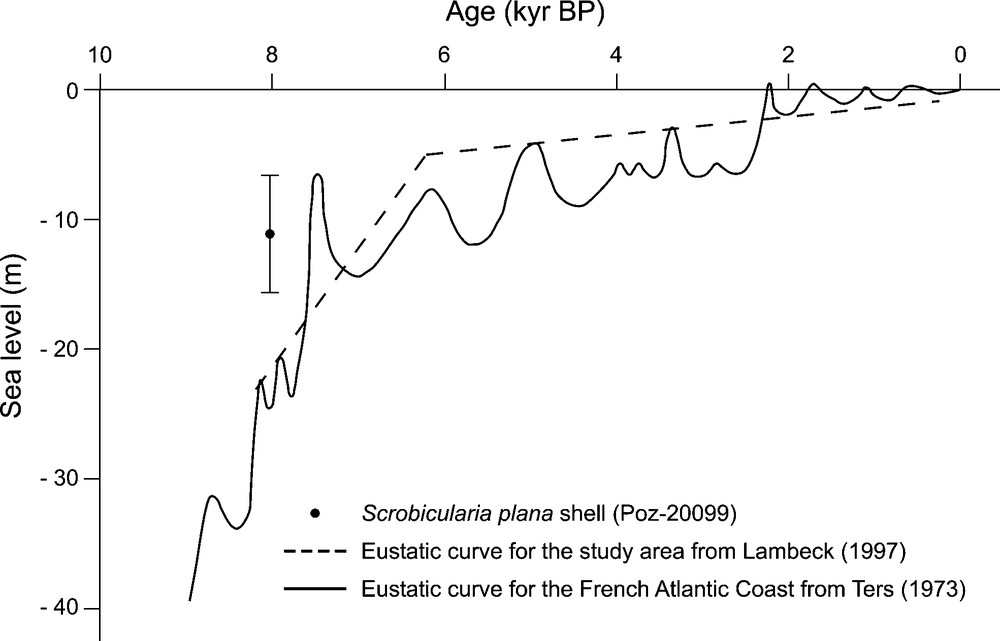
Sea-level curves for the French Atlantic coast over the last 10,000 years, modified from Ters [19] and Lambeck [14]. The black dot represents the relative elevation of Scrobicularia plana shell dating (Poz-20099). The error bar represents the relative uncertainties due to the present-day bathymetric distribution of Scrobicularia plana.
Fig. 4. Courbes de niveau marin pour les côtes atlantiques françaises au cours des derniers 10 000 ans, d’après Ters [19] et Lambeck [14]. Le point noir représente l’altitude relative de la coquille de Scrobicularia plana datée (Poz-20099). La barre d’erreur représente les incertitudes relatives dues aux variations de la distribution bathymétrique actuelle de Scrobicularia plana.
5.2 Evidences of transgressive and regressive successions
Very high resolution seismic stratigraphy, combined with coring results, including grain size analysis and description of mollusc death assemblages, evidences a basal valley-fill (U1.1 and U1.2 seismic units), its upper part dated back to 8030 ± 50 and 7610 ± 40 yr B.P., capped by a mud drape (U4.1 and U4.2 seismic units) dated back to 630 ± 30 yr B.P. This sedimentary succession shows similarities with already investigated valley-fills of the studied area. Indeed, sediment infill in both the submerged Charente and Lay-Sèvre valleys show basal transgressive successions dated back to 6930 ± 40, 6105 ± 35 and 5260 ± 30 yr B.P. and overlain by a mud drape dated to 1230 ± 30, 860 ± 25 yr B.P., and interpreted as the highstand system tract [7]. At the scale of the Marennes-Oléron Bay, the mud drape seems to be homogeneous in terms of both ages (to 630 ± 30 in this study, 850 ± 40 [4] and 860 ± 25 yr B.P. [7]) and grain size (clays to medium silts). Nevertheless, sediments lying below this mud drape are much younger in the western Marennes-Oléron Bay (2205 ± 30 yr B.P., 1.40 m below the mud drape, Uaid2 [7]) than in the eastern Marennes-Oléron Bay (8030 ± 50 yr B.P., 2.5 m below the mud drape and 7610 ± 40 yr B.P., 0.85 m below the mud drape, in this study). This difference between the western and eastern Marennes-Oléron Bay sediment-fill is interpreted as the result of the progressive seaward sediment progradation from the eastern to the western Marennes-Oléron Bay. This seaward progradation has also been evidenced in the surrounding coastal plains (Rochefort marsh [6] and Poitevin marsh [12]), where transgressive successions overlain by regressive mud locally named ‘Bri Bleu’ and dominated by Scrobicularia plana have been also described [22].
The eastern Marennes-Oléron Bay sediment infill seems to be characterised by a sedimentary hiatus between U1.2 and U4.1 seismic units. At the seismic scale, the transition between U1.2 and U4.1 corresponds to EU1 regional unconformity. On VC48, EU1 corresponds to a 0.45-m very fine sands bed including numerous subtidal species and may represent a dense shell bed. Given that U1.2 includes intertidal species and U4.1 includes subtidal species, the base of FS3 can be interpreted as a flooding surface between the transgressive (FS1 and FS2 sedimentary facies corresponding to U1.2 seismic unit) and highstand (FS4 and FS5 corresponding to U4.1 and U4.2 seismic units) system tracts.
6 Conclusion
Relevant complementary methods including geological and ecological approaches have shown a drowned mudflat located from −11.1 to −9.45 m NGF. This drowned mudflat dated back to 8030 ± 50 and 7610 ± 40 yr B.P. was mainly emplaced during the end of the phase of rapid Holocene sea-level rise. This new evidence of former sea level in the Marennes-Oléron bay is close to previously published local sea-level values during the Atlantic climatic period. This drowned mudflat is deposited in an incised valley filled by a typical transgressive succession capped by a highstand mud drape. Such valley-fill succession shows similarities with other valley-fills already described in the studied area.
Acknowledgements
The authors wish to thank the officers and crews of CNRS/INSU Côte d’Aquitaine, Côte de la Manche and Les Deux Mouettes vessels. This study was supported by CNRS–INSU (‘Institut national des sciences de l’Univers) and IFREMER. Special thanks are due to Dr Y. Gruet for constructive comments and help with macrofauna identification. We also thank the two anonymous reviewers for their help to improve the manuscript.