

1 Introduction
During the Lower Cretaceous, Tethys was subjected to the first compressive constraints. During this period, the intra-continental basins continued to receive sediments that recorded the tectonic movements of this time.
In the Tunisian northern Atlas, this period is marked by Triassic extrusions that developed angular unconformities between the Upper Albian deposits and the saliferous structures [8,15].
In central Tunisia, the sedimentary sequences of Lower Cretaceous age were largely studied [1,3,11,12,14]. All these authors announced the variations of facies and thickness in these series, which they connected to a distensive tectonic mode. M’Rabet [14] announced the emergence of the Kairouan Island during the Lower Cretaceous.
In 1990, Rabhi and Ben Ayed [16] and, in 2005, Rabhi and al. [17] evoked the existence of an Aptian compression; in 1995, Chekhma and Ben Ayed [6] and, in 1996, Chekhma [5] showed that in the Lower Cretaceous compressive tectonics were reigning. We describe in this paper the evidence of an early structuring that could be related to the closing of Tethys.
The studied sector (Fig. 1) belonged to the Tunisian central Atlas. It consists in the fitting of Atlasic folds (NE–SW direction). These solid masses are in the Lower Cretaceous heart, surmounted in discordance by the Upper Cretaceous series. Miocene and Quaternary compressive tectonics affected a sedimentary cover separated from the ante-alpine base by a decollement level consisting of plastic Triassic and compartmentalized this field in tabular zones occupied by the Gafsa vast plains in the southwest and Sidi Bouzid in northeast and in zones occupied by folded structures in the Northwest and the Southeast [5], whose limits coincide with the great accidents F1, F2, and F3 (Fig. 1). Jebel Meloussi belongs to this sector, but is moulded on a great fault (F3) that has an exceptional almost east–west direction.
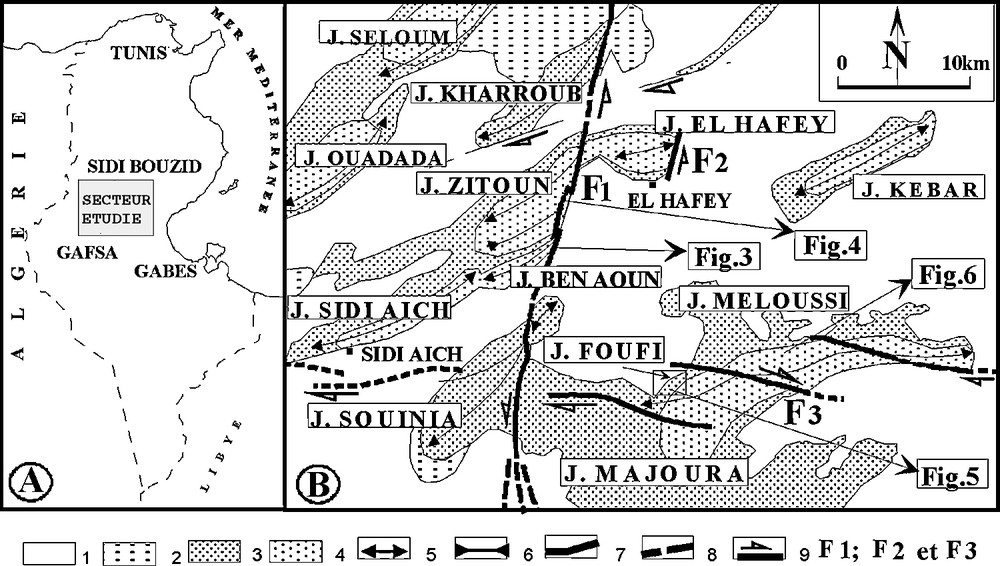
(A) Studied sector. (B). Studied structures: 1, Quaternary; 2, Neogene; 3, Upper Cretaceous; 4, Lower Cretaceous; 5, anticlinal axis; 6, synclinal axis; 7, visible fault; 8, Supposed fault; 9, strike-slip fault; F1, north–south Sidi Ali Ben Aoun fault; F2, north–south El Hafey fault; F3, east–west Meloussi fault system.
Fig. 1. (A) Secteur étudié. (B). Les structures étudiées : 1, Quaternaire ; 2, Néogène ; 3, Crétacé supérieur ; 4, Crétacé inférieur ; 5, axe anticlinal ; 6, axe synclinal ; 7, faille visible ; 8, faille supposée ; 9, décrochement ; F1, faille nord–sud de Sidi Ali Ben Aoun ; F2, faille nord–sud d’El Hafey ; F3, système de failles est–ouest de Meloussi.
2 The Lower Cretaceous of central Tunisia
The Lower Cretaceous (Fig. 2) was initially subdivided in lithological units [3]; recently, precise age details were brought [7,9,13].
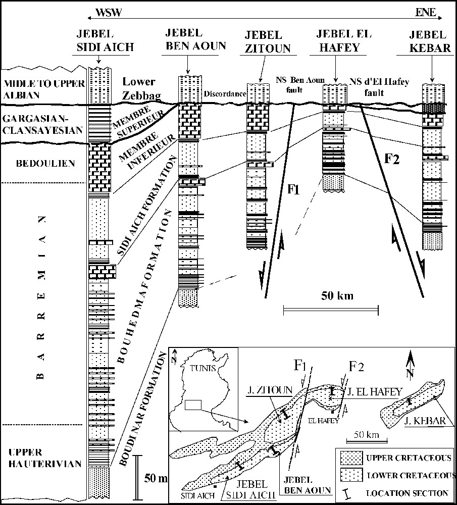
Correlation between the Cretaceous lithological units of the studied area.
Fig. 2. Corrélation entre les unités lithologiques crétacées de la région étudiée.
The Hauterivian is represented by the Boudinar Formation. It is primarily a sandy unit (ends, means and especially coarse) containing rare silty last on in its higher part.
The Upper Hauterivian–Barremian includes the lithological units of Bouhedma and Sidi Aïch:
- - the Bouhedma Formation is made up of fine limestones, locally oolite and bioclasts, of rolled dolomites, gypsum, sometimes variegated clays and fine sands;
- - the Sidi Aïch Formation is generally a sand entity, fine to very fine, white or grey beige. This entity contains at its base clays, silty clays and carbonated benches.
The Upper Barremian–Aptian covers all the Orbata Formation. This one is subdivided into two members or lower Orbata and higher Orbata [7,13]:
- - the lower limb of Orbata (Upper Barremian–Bedoulian) is represented by an argillocarbonate bar [4,5];
- - the upper limb of Orbata (Gargasian–Clansayesian) rests in discordance on the lower Orbata. It is formed by marl alternations, limestones, sands, and dolomites.
The Middle and the Upper Albian are represented by the lower limb of the Zebbag Formation. This one rests in discordance on one or the two members of the Orbata Formation. It is made up of clays, marls, carbonates, and lumachelle intercalations.
3 Tectono-sedimentary analysis
The analysis of the series of the Lower Cretaceous on the whole of the studied outcrops shows important variations of facies and thickness (Fig. 2). While passing from Jebel Sidi Aïch to Jebel El Hafey, the thicknesses decrease by three quarters, and the facies that mainly consisted of argillocarbonates in the J. Sidi Aïch become increasingly sandy in the J. El Hafey. In detail, these variations appear on both sides of the great accidents F1 and F2. These old faults started to play at least since the Lower Cretaceous. They played the mechanical part of the limit and delimited structures without periclinal closing, such as J. Sidi Ali Ben Aoun, J. Zitoun, and J. El Hafey (Fig. 1). The geological investigation detailed in this area concerned the indices of this early tectonics (folds, faults, and discordances) fossilized in the series of the Lower Cretaceous and more particularly in the lithological units that cover the interval Hauterivian–Upper Bedoulian (lithological units of Bouhedma, Sidi Aïch, and lower Orbata).
3.1 Synsedimentary folds, synsedimentary discordances and faults
In Jebel Sidi Ali Ben Aoun, the Bouhedma and Sidi Aïch Formations were folded before the deposition of the lower limb of the Orbata Formation. The Sidi Aïch Formation being sandy, it is not possible to see the synsedimentary folds, our observations and our measurements that were carried out at the level of the structures preserved in alternations of the Bouhedma Formation. In the Southeast of this jebel, this formation fossilizes folds. The stereographic representations made it possible to determine the axes of these folds, which are directed N33 with N46 and plunge 23 NE to 30 NE. These folds are covered in discordance by alternations of the same formation or by the lower limb of the Orbata Formation allotted to the Upper Barremian–Bedoulian (Fig. 3). By places, the benches of the lower limb of the Orbata Formation, without being deformed, truncate certain levels, which form early folds, making with them a very clear angular unconformity (Fig. 4B). The orientation of the axes of the folds (N20 to N35) lets us suppose that this crumpling results from a NW–SE directed compression close to N115 to N125.
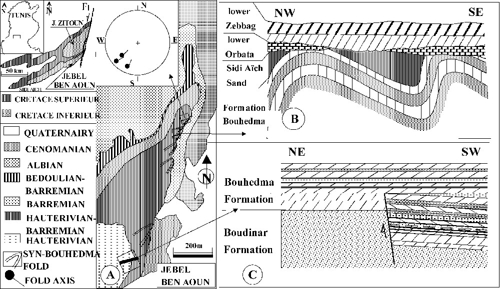
(A) Jebel Ben Aoun geological outlines and synsedimentary folds axis; (B) Bedoulian and Albian discordance on various levels of the Barremian; (C) synsedimentary fault in the base of the Bouhedma Formation.
Fig. 3. (A) Esquisse géologique de djebel Ben Aoun et axes des plis synsédimentaires ; (B) discordance du Bédoulien et de l’Albien sur différents niveaux du Barrémien ; (C) faille synsédimentaire affectant la base de la formation Bouhedma.
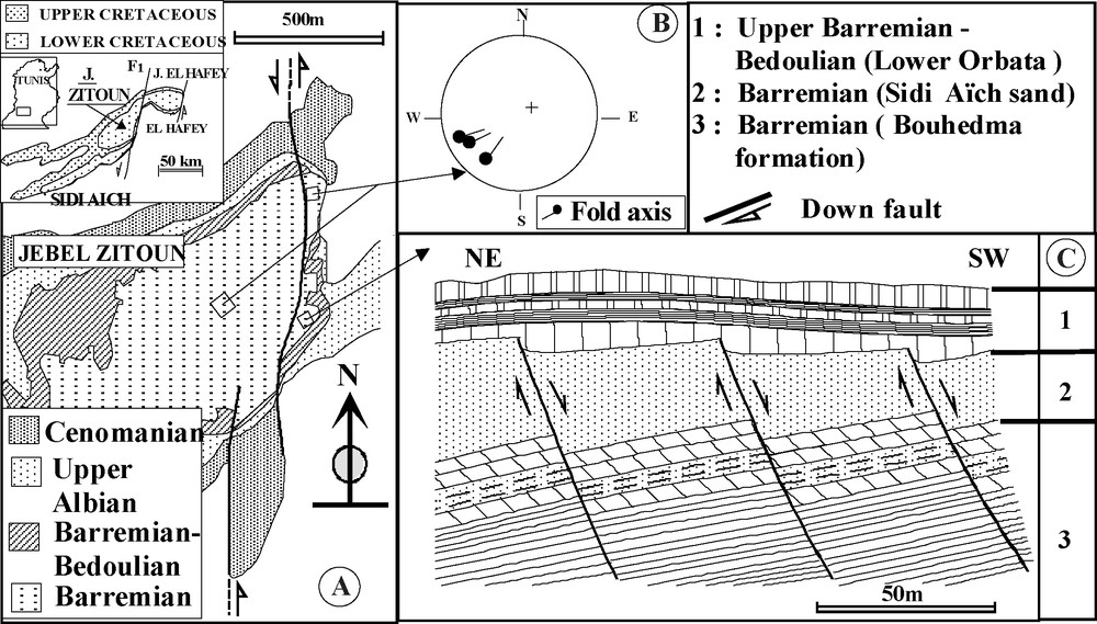
(A) Geological outlines of Jebel Zitoun; (B) synsedimentary folds axis; (C) synsedimentary faults affecting the Barremian (top of Bouhedma and Sidi Aïch sands).
Fig. 4. (A) Esquisse géologique du djebel Zitoun ; (B) axes des plis synsédimentaires ; (C) failles synsédimentaires affectant le Barrémien (sommet de Bouhedma et sables de Sidi Aïch).
At the extreme East of Jebel Zitoun, the Bouhedma Formation shows a fold covered in progressive discordance by the Sidi Aïch, lower Orbata and lower Zebbag Formations (Fig. 4A). The axis of this fold is directed N30 with a plunging of 20° towards the northeast and supposes also a compression NW–SE close to N130 (Fig. 4B). In the middle of this same jebel (Fig. 4A), one observes several folds in the Bouhedma Formation, above which come in angular unconformity alternations of the same formation, of Barremian age (Fig. 4C).
At the level of the northern side of Jebel Foufi, the Bouhedma Formation fossilized synsedimentary hectometric folds in its higher part. The axes of these folds are directed N45 with N50 and respectively plunge 14° to 21° towards the southwest (Fig. 5). These tectonic structures are sealed by benches of the same formation. At the level of this jebel, the geological cartography also shows that sands of Sidi Aïch disappear by places and are rectified lower than the vertical Orbata is angularly unmatched on various training levels of Bouhedma (Fig. 5).
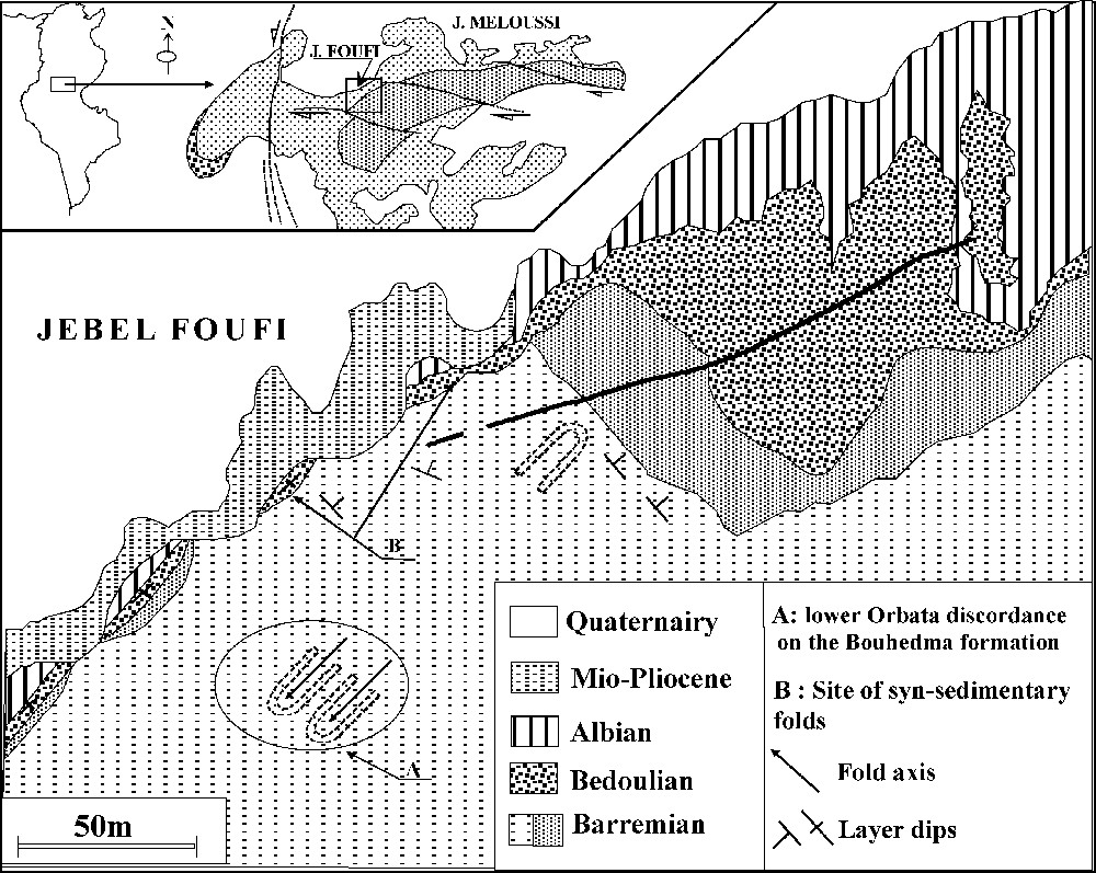
Geological map of Jebel Foufi; representation of the synsedimentary Barremian folds and discordance of lower Orbata on Bouhedma and Sidi Aïch Formations.
Fig. 5. Carte géologique du djebel Foufi ; représentation des plis synsédimentaires barrémiens et discordance de l’Orbata inférieur sur les formations Bouhedma et Sidi Aïch.
3.2 Synsedimentary faults
In Jebel Sidi Ali Ben Aoun, the Bouhedma Formation shows on its southeastern side a decametric synsedimentary normal fault (Fig. 3C). This fault is of N115 direction and dips 80° towards the south (after swing), affecting the base of the formation. It shifts the first bar of the formation of about 50 m. In the southern compartment, the basal bar of the Bouhedma Formation is surmounted by carbonate alternations, sands, and clays. Those have a total thickness of 62 m. These alternations are covered by dolomites of 2 m thickness that seal the fault and pass into the northern compartment to cover directly the bar that defines the base of the Bouhedma Formation. Above, with a 100-m thickness, the Bouhedma Formation contains a lenticular level of monogenic conglomerates of 1-m thickness. This level is spread out laterally over a hundred metres. It is affected by two synsedimentary normal faults of N120 directions and dipping 80S. These two faults shift this last level of 1 m, while defining compartments subsided towards the south and compartments rising towards the north. These accidents are prolonged in alternations of top; then they are sealed by carbonates. These faults testify to a distensive mode of NE–SW direction, as they can also result from a compression of NW–SE direction that reigned in the area in the Upper Hauterivian–Barremian. In the same levels, one notes the presence of several small synsedimentary normal faults of the same family as the latter.
On the eastern side of Jebel Zitoun, the summit bar of the Bouhedma Formation is truncated by three synsedimentary pluridecametric faults (Fig. 4B). These affect the dolomitic bar in three different places. These faults of 10–18 m of rejection towards the south are of N100 direction in N120 and dip of 80–85° towards the southwest (after swinging). Above the Bouhedma Formation, the sands of Sidi Aïch seem to be affected by these accidents, whereas the lower limb of the Orbata Formation covers the whole, without being truncated. Above carbonates, lower Orbata shows a light thickening on the level of the southern compartment of each fault. These various visible synsedimentary faults in the Bouhedma and Sidi Aïch Formations testify to a period of extension following a NE–SW direction.
At the Khanguet Zebbes level of Jebel Meloussi (Fig. 6), the top of the alternations of the Bouhedma Formation shows a large dolomitic bar of a score of metric thickness, which is spread out over more than 2 km. This one is limited to the east and the west by two normal faults of NW–SE direction . Toward the east and the west, the equivalent side of this bar is represented by dolomite alternations, sands and clays. Above, sands of the Sidi Aïch Formation that surmounts this bar and its equivalents show a constant thickness testifying to an early play of the two faults. These accidents affect currently the Cretaceous series, testifying to a late play.

Jebel Meloussi: location of the observation site; synsedimentary fault affecting the Barremian.
Fig. 6. Djebel Méloussi : localisation du site d’observation ; faille synsédimentaire affectant le Barrémien.
4 Conclusion
These tectonic data observed in the central Tunisian Atlas associated with those in other areas show that the sedimentation of the Lower Cretaceous was controlled by a compressive mode that is probably related to the closure of the Tethys. These new data show that the current configuration of the Tunisian Atlas results from the superposition of several kinds of tectonic structuring. Indeed, the folds of this Atlas started to be outlined during the Lower Cretaceous (Upper Hauterivian–Barremian in the Lower Aptian). This compressive mode, also mentioned in Algeria [2], is underlined by a NW–SE-directed compression, which persisted in the Aptian [17]. During this period, the NW–SE shortening is compensated by an extension of the NE–SW-directed lengthening of the folds and by the birth of normal faults parallel with the direction of compression. This tectonics parcelled out central Tunisia in high zones that are the seat of facies and thickness variations, of sedimentary gaps and/or angular unconformities and of low zones where the sedimentary sequences are thicker and complete. The direction of shortening during the Upper Hauterivian–Barremian and the Aptian, in other terms the direction of the principal constraint fits well with that generated by the sinistral displacement of Africa versus Europe during the Lower Cretaceous [10]. The superposition of at least two axes at the level of the structures shows that the zones where these Cretaceous folds are outlined remained always favourable to later crumpling (crumpling Atlasic) and that the disturbances in the directions of the faults and the axes of the syn-Cretaceous folds are due to reorientations induced by Atlasic and Quaternary tectonics and the remobilization of the old faults in strike-slip faults (dextral and sinistral).
Acknowledgement
A sincere gratitude to Mr Jacques Argelier who expressed his interest in my article and took the trouble of presenting it.