

1 Introduction
Karstic aquifers present large voids due to limestone dissolution by meteoric waters. The superficial river network is poorly developed or absent, and rainwater infiltrates directly. Ford and Williams [13] estimated that 25% of the global population are supplied largely or entirely by karst waters. Nevertheless, the distribution of voids in karstic aquifers is generally unknown [2], which is a serious obstacle for water policy, particularly in coral karstified islands, where freshwater is only available from the underground water lens [37]. Hence, detailed knowledge of their karstic system is required for the sustainable management of water resources and to assess its vulnerability to climatic and anthropogenic disturbances.
The response to rainy events has been considered as a valuable indicator of the karstic development of a limestone formation [9,25]. The method proposed by Mangin [26] is based on the analysis of the cross correlation between rainfall and the water level. It has been assessed by Padilla and Pulido-Bosh [32] and is presently widely accepted. A delay of a few hours between rain and the water level rise in caves is associated to an efficient drainage of surface waters by a series of well connected pipes, i.e. to a fully developed karstic network. Conversely, a delay amounting to weeks indicates a rather granular medium or unconnected karstic voids, that do not allow fast transfer between the surface and the phreatic zone. In the tropical island of Guam (West Pacific) Contractor and Jenson [8] and Jocson et al. [18] have shown that the response to rain was important in amplitude (1.5 m) and obtained in less than one day during the rainy season, while it was subdued when rain followed dry conditions.
Temperature may be also considered as a non-conservative tracer in karstic systems [30] and temperature records have been proved to be an efficient method to characterize flow in various karstic systems [10,15,35]. Rainwater brings its own temperature information which is smoothed during its travel toward the phreatic zone. The temperature signal is maximum if rainwater flows fast in wide channels and weak if it flows in narrow fissures.
The present paper is devoted to an analysis of the karstic system of the Lifou Island. The geology of the island and a comparison of karstic channels with known fracture orientations are discussed first. Then, freshwater temperature and water level records are presented and their relation with rainfall is analysed. A comparison is done with similar data obtained in the Baget karstic watershed (Ariège, France), which is recognized as a continental karst, with a high organisation level [25] and with the chalk of the Basin of Paris which is charaterized by a low organisation level. Finally, the hydraulic properties of the Lifou karst and their impact on drinking water management are discussed.
2 The Loyalty Islands and their freshwater lenses
The Loyalty Islands are a series of islands in the SW Pacific built by carbonate deposits and coral growth on subsiding Miocene seamounts [3] which are now uplifted on the elastic forebulge formed by the Australian lithosphere before its subduction at the Vanuatu Trench (Fig. 1a). The top of the bulge is located between Lifou and Maré reaching 100 m and 130 m altitude, respectively [11,12]. The SAGE program (2001–2005), funded by the “Province des Îles” of New Caledonia has been devoted to the study of geology and hydrology of the Loyalty Islands and focussed particularly on their sustainable development [1,23]. It was cooperated by the IRD and the University of New Caledonia (UNC). During the same period, the geological map of Lifou has been published by Maurizot and Lafoy [28]. Lifou and Maré present at their outer rim limestones derived from coral reefs that were bordering the former atoll, while the centre of the islands consists of partly dolomitized biomicrite typical of a lagoon sedimentary filling [7], with frequent traces of dissolution and biochemical erosion [6]. These two facies are clearly distinguished at the outcrop, the outer cliffs being characterized by a rugged landscape including indurated corals, while the innerland limestones are microfissured with a common chalky texture [28]. The coral limestones are proposed to lie on a carbonate platform [6], known as the Rhodolite platform in Maré, but which is not outcropping in Lifou [28]. The depth to the basement is unknown in Lifou and Maré, although localized basaltic outcrops are known in Maré, but one can hypothesize that this basement lies below the present sealevel, since it was never detected either in the well drilled for freshwater supply or along the border cliffs of both islands.
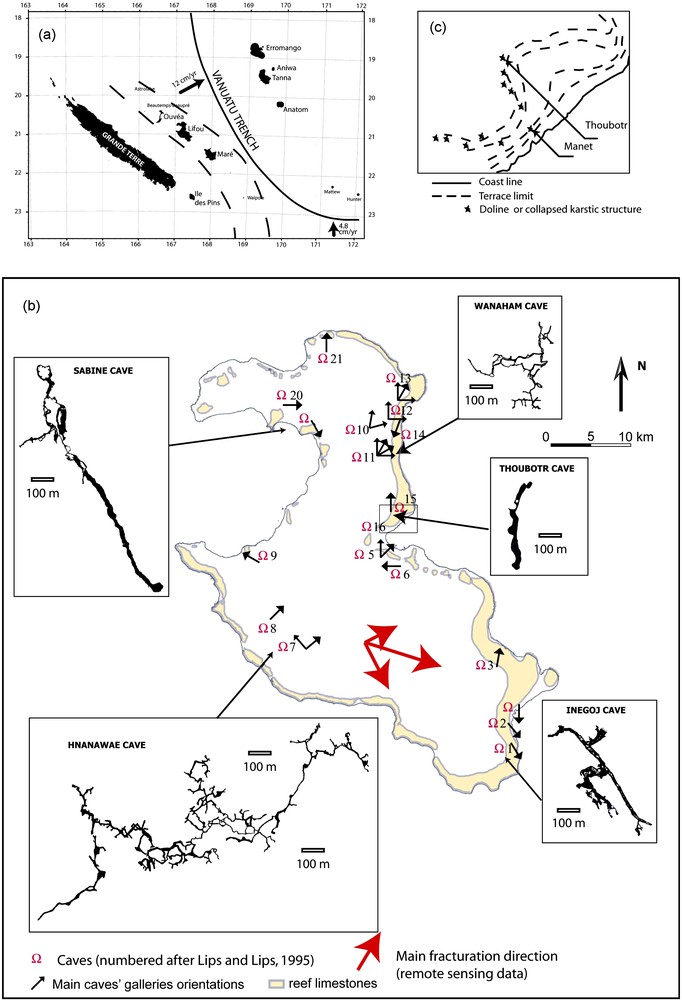
(a) Tectonic setting of the Loyalty Islands region. (b) Location of main karstic networks in Lifou, orientation of their galleries (black arrows), and maps of selected caves. The coral facies is in yellow (after Maurizot and Lafoy [28]). The red arrows denote the main fracture orientations found on satellite and aerial images (Table 1) and their relative importance so that the longest arrow represents nearly 85% of the cumulated fissure length. (c) Enlargement of the rectangle near cave number 15, i.e. Thoubotr.
(a) Situation tectonique de la région des îles Loyauté. (b) Position des principaux réseaux karstiques à Lifou, orientation de leurs galeries (flèches noires) et plan de certaines d’entre elles. Le faciès corallien est en jaune (d’après Maurizot et Lafoy[28]). Les flèches rouges représentent les trois familles de fissures déduites des photos satellites et aériennes (Table 1) ainsi que leur importance relative. La flèche la plus longue représente environ 85 % de la longueur cumulée de fracture. (c) Agrandissement de la zone rectangulaire autour de la grotte de Thoubotr (grotte numéro 15).
The climate of New Caledonia and of the Loyalty Islands is influenced by ENSO (El Niño-Southern Ocsillation) phenomenon and strong climatic variability results from the succession of dry El Niño and rainy La Niña events [33]. The mean annual rainfall is 1500 m, with a rainy season lasting from December to March, during which tropical storms may produce 300 mm of rainfall in a few days [29].
Freshwater is located inside an underground lens-shaped body which overlies seawater and can be described in a first approximation by the Ghyben-Hersberg law [1,20]. Freshwater flows from the centre of the island toward its borders where several springs can be found along beaches. As these springs are not used for drinking water, little is known on their variability.
Similar carbonate tropical karsted islands have been extensively studied in the West Atlantic-Carribean (Bermuda and Bahamas) and the Marianna regions which led to the concept of eogenetic karst, initially proposed by Vacher and Mylroie [37], which characterizes small islands of which the carbonate matrix has never been compacted nor cemented due to burial diagenesis. Owing to their limited size, their whole hydrological system is controlled by Quaternary eustatic sealevel changes. A series of caves commonly develop near the coastline during sea-level stillstands. Such caves are now visible at the periphery of the Loyalty Islands due to their uplift. These caves were attributed by Bögli [5] and Mylroie and Carew [31] to corrosion resulting from mixing of waters of different salinities at the freshwater lens tip. Although Plummer et al. [34] and recent studies summarized in Rezari et al. [36] have shown that dissolution was controlled by the dissolved CO2 and by the mixing rate, rather than by salinity, the term of mixing corrosion is kept here for dissolution arising at the different boundaries of the freshwater lens. Mixing corrosion may also operate at the intersection of different fissures families [14] and at the different boundaries of the freshwater lens [17].
3 Distribution and orientation of caves in Lifou
In most continental karst, the limestone matrix is almost impervious, and karstification is known to progress along discontinuities such as joints or faults. In small karsted islands, the carbonate material includes voids of various sizes, especially if it derives from coral reefs, as on the borders of Lifou. Moreover, the mixing corrosion mechanism implies that dissolution is located at the chemical gradient zones. Jenson et al. [17] have shown that this resulted in a looser control of cavity distribution and main orientation by existing discontinuities. Here we take advantage of a fair coverage of cave distribution and orientations (Lips and Lips [22] and our field studies) and of remote sensing studies of discontinuities distribution [16,28] to assess their mutual relationships in Lifou.
As part of the SAGE program, linear structures visible on aerial and satellite images have been mapped by Huaman [16,28]. At the outcrop, on the coral terraces of the border of Lifou, these linear structures correspond to low aperture cracks, with no noticeable displacement. Due to the dense vegetal cover inside the island, fractures are hardly observed except in quarries, where the lagoon type limestones present generally a non-cohesive facies which also prevents observation of discontinuities (Huaman and Cluzel personnal communications 2003–2005). Thus, the observed lineaments were considered as the most reliable set of discontinuities in Lifou. They are organized in three families (Table 1) that are linked to the geological context of the subduction and to the onset of a collision between the Loyalty Ridge and the Vanuatu Trench at the SE of Maré [4]. Fracture distribution present large dispersion but the orientation histogram is stable if Lifou is divided in 5 × 5 subzones [4], and the main orientation is also found on the present reef platform [16]. These discontinuities can be considered therefore as discontinuities linked to the present tectonics, and there is no previous fissure family on remote sensing data.
The three lineament families observed by remote sensing (after Bogdanov et al. [4])
Les trois familles de linéament observées par télédétection (d’après Bogdanov et al. [4] )
| Fracture density (m/km2 per degree) | Mean orientation (°) | Standard deviation (°) | |
| Family F1 | 2.9 | N 152.5 | 4 |
| Family F2 | 49.9 | N 107.5 | 16 |
| Family F3 | 10 | N 62.5 | 7 |
The major cave systems are located in the borders of the island, with some notable exceptions: the longest karstic networks, i.e. the Wanaham (WNH) and the Hnanawae (HNW) caves are located in the inner island (Fig. 1b). The cave entrance consists generally in a collapsed area, which gives access to one or several galleries gently dipping downward (upward in some instances), for which the main orientations are reported on Fig. 1b. The floor of these caves is always covered by fallen blocks of various size, which indicates that collapse is a significant process in cave formation. HNW and WNH consist in a series of linear galleries with orientation controlled by the present fissure distribution for HNW, and in a lesser extend for WNH. Caves located near or inside the ancient reef facies present a wide collapsed entrance giving access through a collapsed zone dipping at angle of 30° to 50° to subhorizontal galleries, for which orientations seem to be controlled by the present or ancient shoreline. This is best evidenced near Wé along the 70 m contour. This contour is marked by a series of collapsed structures which are probably traces of caves formed at the sea-level and which are now at 70 m due to the combined effects of sea-level changes and of the uplift of the island.
The main conclusion of this section is that the different caves of Lifou are not controlled, as a whole by the present fissure distribution. The two longest networks, belonging to the inner island (WNH and HNW) could be similar to continental maze-type cave networks controlled by pre-existing discontinuities, but for one of them, these discontinuities poorly match the three fissure families observed on the island. On the other hand, near the ancient corallian rim of Lifou, caves consist of elongated chambers with orientation parallel to the paleo- or present shoreline. Due to their proximity to coast, they seem to be flank margin caves in origin [31]. They cannot be considered as one of pure cave type presented by Jenson et al. [17] for small carbonate islands, although they might be considered as a combination of pit caves and flank margin caves. Although collapse processes may be significant in these cave growth and upward migration, their orientations cannot by explained solely by collapse, and might be controlled by flank margin voids developed during a previous sea-level stillstand.
4 The rain signal
4.1 The monitoring device
A water level network has been set up in Lifou by UNC, IRD, and the Water Resource Observatory of New Caledonia. It includes four sensors, two of them located in wells, two in caves. We discuss here data from Manet and Thoubotr caves, which are far from any pumping well. The two caves are located near Wé, the main city of the island (Fig. 1c) and both give access to the freshwater lens. Near these caves, outcropping limestones include numerous coral skeletons and present a chaotic topography derived form the ancient reef as well as typical epikarstic structures such as dissolution-enlarged fissures at least a few meters deep. Thoubotr belongs to the series of caves located near the paleo sea-level at 70 m. It presents a wide collapsed opening giving access to two galleries, gently dipping toward the north and more steeply southwards (Fig. 1b). Since the southern gallery only reaches freshwater, it was used for monitoring. The Manet cave is a circular 100 m wide collapsed area, developed in the outer coral belt of Lifou, limited by vertical cliffs, and giving access to freshwater at its base. It was observed that centimeter-sized eddies generated at the water surface were advected seaward at few cm/s velocity. This confirms the observations made by Koch [20], that markers placed at the water surface in the nearby Avio cave were advected seaward independently of the water level in the cave, and hence, independently of tide. The water level is measured in Thoubothr and Manet using Orphimedes™ devices (Ott intruments) with a millimeter precision and a 30 min time step. The two devices have been levelled. Water temperature is measured at Thoubothr using a Hobo microstation and a 12 bit sensor. Its precision, as given by Hobo is 0.1 °C, with an associated sensitivity of 0.03 °C. Since the precision is limited by the drift of the thermistor, it can be improved by calibrating the sensor with a reference thermometer. This has been done at the onset and the end of the campaign by comparison with a 0.01 °C precision device. Moreover, as suggested by Hobo 10 successive measurements have been averaged to increase the signal to noise ratio. This allowed us to estimate that the 0.03 °C accuracy was achieved during our records. The temperature sensor has been placed at 1.5 m depth after having checked that the freshwater temperature is constant in the uppermost 4 m.
4.2 Water level in Thoubothr and Manet
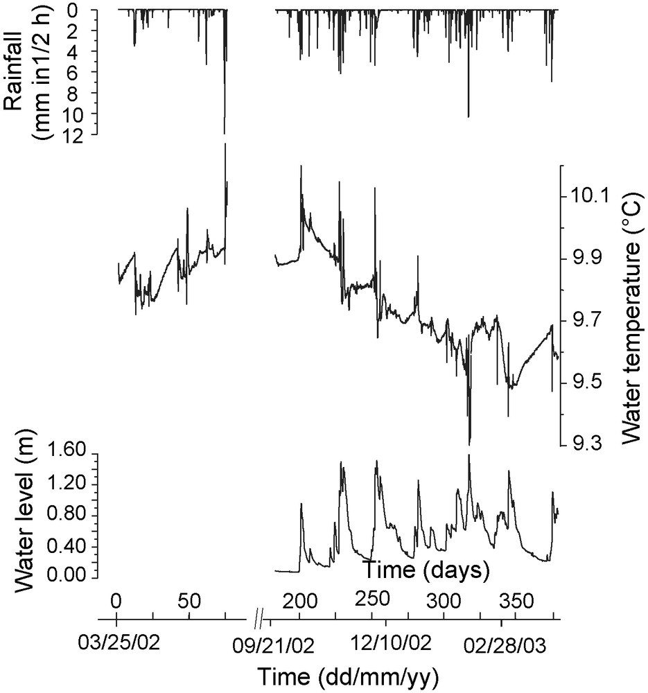
The water level in Thoubotr (orange curve on Fig. 2) is characterized by a 0.2 m amplitude tidal signal and by the succession of neap tides and spring tides shown by the curve envelope. Tidal components near 12 h and 24 h have been removed by low pass filtering (heavy orange curve on Fig. 2). However, since tide includes large period components, a tidal signal may still be included in this filtered curve. Moreover, as the freshwater lens lies on seawater, any long term change of the sea-level, such as those linked to ENSO oscillations [24] is transmitted to it. Hence, the freshwater level in Lifou, even after removal of its 12 h and 24 h components still includes an oceanic signal.
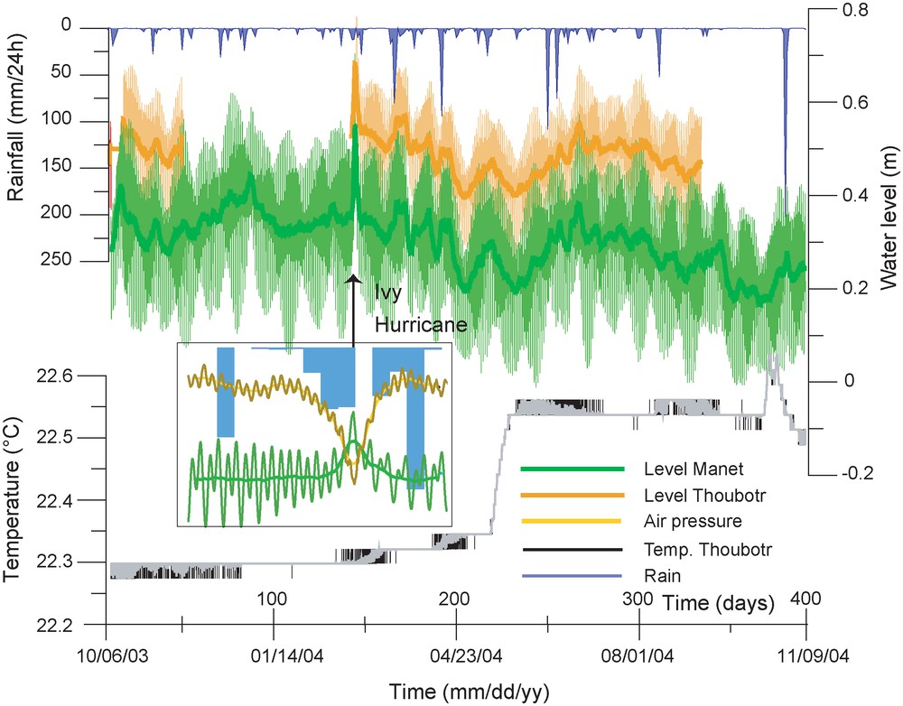
A one year record in the Thoubotr and Manet caves; top: rainfall at the station of Wanaham 15 km north of Wé (inverted scale); middle: water level in the Thoubotr (orange) and in the Manet cave (green). The bold curves are filtered from the 12 and 24 h components corresponding to tide; bottom: water temperature in Thoubotr: raw data (black curve) and 10 points (2 h 30) moving average (grey curve). Inlay: enlargement during the Ivy Hurricane including the daily rainfall (in blue), the air pressure (in brown) and the water level at Manet. The amplitude of the air pressure signal is 12 hPa. Meteorological data have been provided by Météo France.
Un an d’enregistrement à Thoubotr et Manet ; en haut : pluviométrie à la station de Wanaham, située à 10 km au nord de Wé (échelle inversée) ; au milieu: piézomètrie à Thoubotr (en orange) et à Manet (en vert). Les courbes en gras ont été filtrées des composantes à 12 et 24 heures qui correspondent à la marée. En bas : température de l’eau de Thoubotr : données brutes (en noir) et lissées par une moyenne sur 10 points (en gris). En incrustation : agrandissement pendant le passage du cyclone Ivy comprenant la pluie journalière (en bleu), la pression atmosphérique (en brun) et le niveau d’eau à Manet. L’amplitude totale du signal de pression atmosphérique est de 12 hPa. Les données météorologiques ont été fournies par Météo France.
The water level in Manet (green curve on Fig. 2) also includes a tidal component of a near 0.3 m amplitude, slightly larger than in Thoubotr, as a result of its proximity to the coast. However, when components at 12 and 24 h are filtered (heavy green curve), the resulting signal is very similar to that of Thoubotr. As the Manet record is continuous, it will be used for further quantitative analysis. At a first look, both signals seem to present a correlation with rainfall, each rainy event being associated with a water rise.
The largest peak amplitude in the signal is recorded at the end of February 2004 and corresponds to the Ivy Hurricane, which was associated with winds reaching 200 km/h. This hurricane was at its nearest point to Lifou on 27 February 2004 and induced a total rainfall of 66 mm, which is a rather low amount for a tropical depression. The water rise in Manet and Thoubotr has been dated with precision since we were present on Lifou on February 24 and 25, and therefore we were able to control the clocks of our devices. During the hurricance, the atmospheric pressure, recorded hourly at the Wanaham station, 15 km north of Wé, fell by nearly 12 hPa, and the freshwater rose simultaneously by nearly 0.3 m, and by 0.2 m if low pass filtering is applied (Fig. 2, inlay). Conversely, no relationship between freshwater level and rainfall appears. A pressure drop of 12 hPa induces a 0.12 m sea-level rise due to the inverse barometer effect. Moreover, heavy winds during hurricanes may induce a sea-level rise reaching 1 m, which is transmitted to the freshwater lens through a low pass filtering effect depending of the distance to the coast and of the permeability of the porous limestone. As no tide gauge exists near Lifou, this could not be checked, however. From the single Ivy event, it seems that the freshwater level rise is associated with the depression itself rather than with rainfall. This is now explored on our whole records using cross correlation analysis.
The cross-correlogram between water level and rainfall displayed in Fig. 3 shows a peak indicating that water raises systematically one day after rain. However, if the water level is corrected from the inverted barometer effect (Fig. 3), this peak is absent. This indicates that the short range correlation observed between rain and water level on Fig. 2 is only the effect of the low pressure associated with rainy events, as for the Ivy Hurricane. It seems, however, that there is a tendency for a lower water level 20 days before rain and a higher one 20 days after it, but, owing to the high noise level in the correlogram, this tendency has still to be confirmed when longer records will be available.
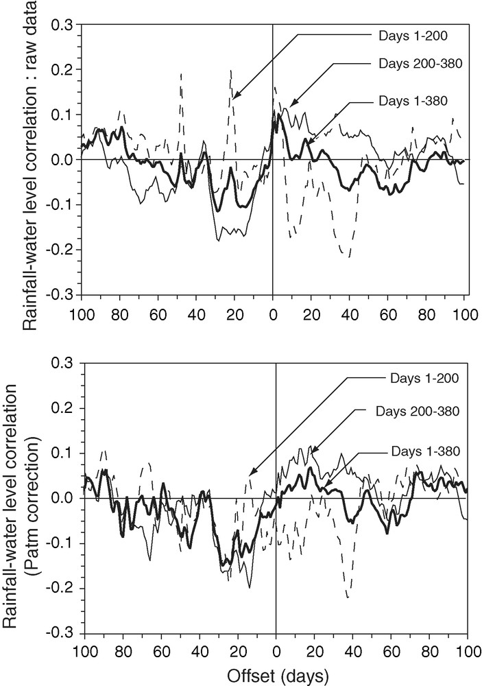
Cross correlogram between rainfall and water level. Top: raw data, bottom: after correction for the inverse barometer effect. The different curves are computed on different time periods, indicated in days since the beginning of the records of Fig. 2.
Corrélogramme croisé entre la pluie et la hauteur d’eau. En haut : données brutes, en bas : données corrigées de l’effet de baromètre inversé. Les différentes courbes sont calculées sur différentes périodes indiquées en nombre de jours depuis le début des chroniques (voirFig. 2).
So, the main conclusion is that infiltration of rain do not induce a noticeable water level rise either in Manet or in Thoubotr.
4.3 Water temperature in Thoubotr
The temperature data do not present any visible relationship with rain. The water temperature (Fig. 2) is almost steady, except for two events, the first one consisting of a gradual rise of 0.25 °C during May 2004, which could be related to no other event except the onset of the cool season, and the second one occurring at the end of October 2004, a few days before rain. The cross correlation between water temperature and rainfall is low and not robust. As it is impacted by the temperature event of May 2004, this event has been fitted by a moving average on a 25 days window and removed from temperature signal. Even with these filtered data the cross-correlogram is noisy and unstable (Fig. 4). It is mainly influenced by the single event occurring in October 2004 at the end of the record so that the correlogram computed with the whole record is very similar to that involving the last 180 days, only, and very different from the one involving the first 180 days. Therefore, we show also a correlogram computed with the first 350 days, for which this last event has been excluded. One notes that the water temperature seems lower before rain and higher during the 10 days following rain. However, this effect should still be confirmed with longer time series, which could possibly allow to increase the signal to noise ratio in the correlograms.
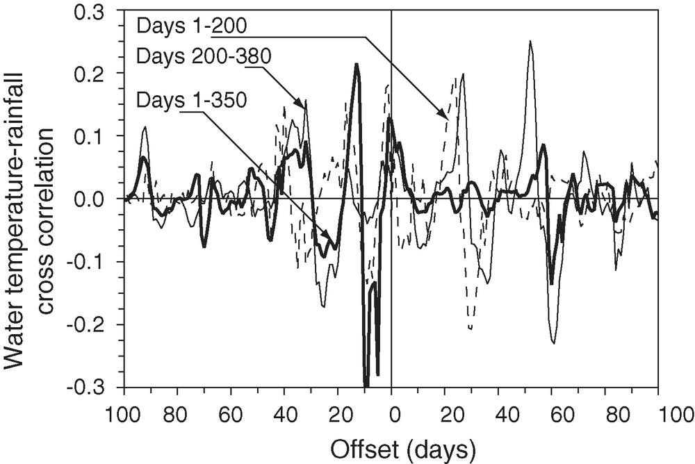
Cross correlogram between rainfall and water temperature. The different curves are computed on different time periods, as in Fig. 3.
Corrélation croisée entre la pluie et l’eau de la nappe. Les différentes courbes sont calculées pour différents intervalles de temps, comme enFig. 3.
As for the water level, it remains that the signal possibly produced by rain in the temperature is very weak, less or equal in amplitude than 0.03 °C, the precision of measurement.
4.4 Comparison with the Baget watershed (French Pyrenees)
Similar data have been recorded by Genthon et al. [15] in the submerged part of the La Peyrère cave in the Baget watershed, known as continental karstic system developed during a tectonic event inducing a fissure porosity able to drive dissolution [25]. The Baget watershed includes several swallow holes bringing rainwater directly to the phreatic zone during flood events. The rain signal is known to propagate toward springs in a few hours [25]. Water temperature and water level have been recorded there during one year (Fig. 5) with a precision and time step similar as in Lifou. In these records each rainy event is associated to a temperature signal amounting to a few tenth of degree and a water level rise of the order of magnitude of 1 m during the recorded period. Moreover, it has been observed that flood events during spring may reach 10–20 m in amplitude in the cave [25]. The cross-correlation between the water level and rainfall is stable and produces a single well defined peak at a 6 h delay. The cross correlation of rainfall with water temperature is not stable, summer storms producing generally a warm signal, while rain occurring at the end of winter produces snow melting and therefore a cold signal. It is also suspected that different infiltration modes may be involved, depending on the season and the amount of rain, and that a non-permanent river may be swallowed toward the base of the cave, 50 m under the water surface [15].
Rainfall (top, inverted scale), water temperature (middle) and water level (bottom) in the La Peyrère cave, Baget watershed, French Pyrenees (adapted from Genthon et al. [15]).
Pluviométrie (en haut, échelle inversée), température de l’eau (au milieu) et piézométrie (en bas) dans la grotte de La Peyrère, bassin du Baget, Pyrénées françaises (adapté de Genthon et al.[15]).
This example shows that inside a developed Pyrenean karstic system, both water temperature and water level reaction to rain are at least one order of magnitude larger than in Lifou. In the Baget karstic system, the amplitude of the temperature and water level signals are a consequence of a fast drainage of the surface able to bring efficiently water to the phreatic zone. In the following section, we discuss the consequences of the low amplitude of the rain signal in Lifou for the drainage pattern of this island.
5 Discussion and conclusion
Although the coral island of Lifou presents karstic structures on its whole surface, the level and temperature of its freshwater lens do not correlate with rainfall, at least until a few ten days delay. The limited length of our records does not allow assessment of correlation on a seasonal to pluriannual period. This absence of correlation covers also the rainy season, during which Jocson et al. [18] found in Guam, also a small karsted island, a strong response of the water table after a few hours, and for which the isotopic signature of rainwater is generally found in tropical carbonated island [19]. Their interpretation is that during the wet season rainwater is not intercepted by the vadose zone and soil since they are in a high saturation state.
The water temperature in the freshwater lens is steady except for one temperature gradual rise of 0.25 °C at the beginning of the cool season and for another event of 0.1 °C amplitude lasting for 20 days at the end of the dry season. No satisfactory interpretation can be given for these two events, which are not linked to a rainy event. The decrease of sea surface temperature from nearly 30 °C in summer to 20–22 °C in winter (July–September) might be a significant event controlling the dynamic equilibrium between the freshwater lens and seawater. Therefore it could be linked to the 0.25 °C increase of temperature. Contractor and Jenson [8] and Jocson et al. [18] indicate that in the case of Guam the transit time of rainwater across the vadose zone reached a few months during the dry season. This implies that our observed 0.25 °C temperature increase could be also an imprint of thermal gradients present in this vadose zone. Pluriannual temperature records inside the lagoon of Wé, the freshwater lens and the vadose zone are needed to assess these effects. Finally, the main information brought by our temperature data is the lack of any immediate response of the freshwater temperature to rain, which indicates that there is no fast drainage channel connecting the Thoubotr cave and the surface.
Poor connection between underground water and rainfall have also been reported in the chalk of the Basin of Paris, when the chalk layer is overlaid by an impervious layer which prevents karstification [21]. Mangin [27] has also observed that the drip rate in the Niaux Cave (French Pyrenees) was not correlated with rain. Again, this was explained by the presence of impervious sedimentary material clogging karstic voids in association with an impervious soil at the surface. In both examples the absence of any efficient underground drainage network explains the absence of response to rain.
In Lifou, most karstification structures are observed along the borders of the island, in the coral facies, even if some dolines or caves are also known in the inner part of the island. Since the limestone material originates there from biomicrite of the ancient lagoon and present generally at the outcrop a highly recrystallized non cohesive facies, it might be suspected that such type of rock is unable to sustain mechanically karstic voids. This observation must be related to the ubiquitous observation of collapsed blocks covering the cave floor. It is only the presence of an indurated facies at the some places of the inner island and on its borders which allows the development of perennial karstic structures. As these structures represent a low part of the island, their influence on the response to rain is low.
On the other hand, if rain infiltrates fast toward the freshwater lens, but is not concentrated inside a few caves, the water level rise will be only 2.5% of the thickness of infiltrated rain, taking into account a 1/40 relative density difference between freshwater and seawater [20]. Most part of the freshwater lens thickness change would be located at the base at the lens at the boundary with seawater. This could be hardly observed since wells generally do not reach this boundary which is in addition not sharp, as it involves mixing with seawater.
Hence the island of Lifou, although heterogeneous due to the karstification process, presents a poor connection of both its water table and water temperature with rain. The absence of water level signal associated to rain could be explained either by a slow drainage or by an efficient fast drainage of Lifou. However, fast drainage of rain would led to a pronounced temperature signal at Thoubotr. There is some probability that this fast drainage network is developed in some parts of the island, but then it is difficult to understand, why it is not developed also near Thoubotr, although epikarstic structures are widely observed at the outcrop near this cave. Moreover, no temporary ponds nor underground or superficial rivers allowing concentration of rainwater are known in Lifou. The different drainage mechanisms of Lifou could be further explored and assessed by monitoring the flow rate of submarine springs. These springs could be monitored with conductivity and/or temperature sensors since they involve less conductive and colder water than the oceanic water. As infiltration of rain is a key parameter for vegetation development, such measurements could help for the sustainable agricultural development of the Loyalty Islands. Quantitative numerical time dependant modelling including the vadose zone and accounting for the heterogeneity of the transport properties is suggested to integrate the various data in a consistent model for groundwater of Lifou.
Acknowledgements
The present study would not have been possible without the contribution of Michel Lepiller. His kindness and of his knowledge of the various karstic systems were a valuable support during fieldwork and scientific discussions. Météo France is thanked for providing meteorological data, and M. Bakalowicz for his advices. The two anonymous reviewers are thanked for their remarks who help to improve the paper. This work has been partly funded by the PNRH program of CNRS/INSU.