

1 Introduction
Climate reconstruction for the last 6000 years has been carried out recently [15] from lacustrine sediments at Lake Yoa at Ounianga Kebir (20°30′E, 19°N) within the ACACIA project [1]. Lake Yoa is one of the Ounianga lakes, located in NE Chad (Fig. 1) in the desert of the Erdi Plateau region between the Tibesti and Ennedi Massifs [4]. This region is a wind corridor for north-northeasterly trade winds materialized in Fig. 1 by elongated sandy structures visible at this regional scale. Lake Yoa is maintained in a hyper-arid environment (roughly 6 m/yr of potential evaporation and scarce average precipitation of less than 10 mm/yr) by the inflow of groundwater from the lower southwestern end of the Nubian Sandstone Aquifer System (NSAS). An exceptional continuous and accurately dated record [15] was obtained from lake sediments. The analysis of the finely laminated lake-sequence uses a multi-proxy indicator approach: sedimentary data, geochemical data, biological indicators (pollen, spores, aquatic biota). The results correspond with other field studies and climate modeling studies, indicating an overall trend of an aridification phase in the Sahara, from the end of the African Humid Period (roughly 9–7 kyr BP) to present (e.g. [5,7,15–17,18,24,26]). Some major phases in drying have been observed at Lake Yoa, including:
- • the disappearance of tropical and altitude pollen species by 4300 cal yr BP;
- • the evolution of the lake from a freshwater habitat to the present-day hyper-saline oasis (around 3900 cal yr BP);
- • the establishment of today's terrestrial desert ecosystem as the result of continuous vegetation succession (5600 to 2700 cal yr BP);
- • the evolution in regional wind regime with onsets of major dust mobilization at roughly 4300 cal yr BP and the establishment of modern, near continuous northeasterly winds by 2700 cal yr BP.
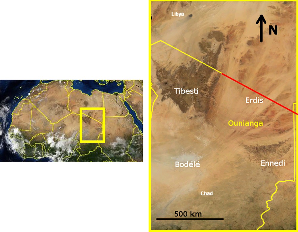
Landsat view of the Ounianga region.
Fig. 1. Vue Landsat de la région des lacs Ounianga.
The evolution of lake conditions is complex. In the case of Lake Yoa, it does not depend solely on climate, but involves some local hydrological and hydrogeological factors [15]. While reconstruction of lake conditions (e.g. salinity, lake levels) is relatively easy in recent years because it is sustained exclusively by the aquifer, looking back towards the Holocene period shows that the water budget involves several factors: precipitation and evapotranspiration, surface water inputs, groundwater inputs, surface water outputs and groundwater outputs. As a consequence, lake levels mirror regional climatic features modified by hydrological effects. This type of interplay was addressed quite early, in the 1970's, and Street [35] reviews earlier lake water balance classifications and applies them to five lakes in the Ethiopian and southeastern Plateau region in Africa, showing the interplay between these factors. While some other authors have oversimplified lake budgets, assuming lake levels to be pure indicators of the discrepancy between precipitation and evaporation (e.g. [14]), the importance of local hydrological and hydrogeological factors have been reported elsewhere [6,15,17].
Through the Holocene period, Lake Yoa was sustained by a regional aquifer, the NSAS [22]. It is situated roughly 200 km half way between the Tibesti volcanic massif (3 summits ranging over 3000 m asl including Emi Koussi, 3415 m asl, highest peak in the Sahara and 8000 km2 above 2000 m asl) to the west and to the Ennedi Mountains to the southeast (maximum height 1450 m asl). In addition to local rainfall, the lake Ounianga region has probably received water inputs from more distant sources where the total amount of rainfall was larger, due to altitudinal effects. These favorable local hydrological and hydrogeological conditions have potentially helped in maintaining higher lake levels, lower salinity and some relicts of gallery vegetation along some river courses or water bodies.
The first issue addressed here relates to the analysis of two major features from Kröpelin et al. [15]. Indeed, tropical species remained present from 6000 yr BP until 4700 yr BP, potentially meaning that at least some humid refuges existed. High altitude vegetation is observed in the sediment (Erica type) with a synchronal evolution. According to Kröpelin et al. [15], the amount of this taxon is high, so that some direct transport mechanisms must account for the transport of these pollens from the Tibesti (the only local candidate with sufficient altitude). Since it is unlikely that the dominant winds are responsible, assuming they are from the north-east, the possibility of transport by river between the Tibesti and Lake Yoa should be examined. This is the first issue addressed here. The second concerns itself with the reconstruction of Yoa Lake level in the more humid phase of the sequence. Around 6000 BP, the expected rainfall of 250 mm/yr [15] corresponds to open grass savannah conditions. Considering the local topographical conditions, the question concerns itself with the extension of 6000 yr BP Paleo-lake Yoa and whether or not its level reached the threshold level guaranteeing that its water was renewed.
The present study proposes a hydrological perspective to the Lake Yoa region. More precisely, the main emphasis is first to assess the surface conditions and flow network (paleo-hydrology) based on a Digital Elevation Model (DEM) obtained from shuttle radar techniques. Second, a preliminary water budget is computed for the maximum extent of the lake, corresponding to a relatively more humid mid-Holocene phase. In this, use is made of available information, primarily from the results of the sequence in Lake Yoa by Kröpelin et al. [15] and those from global climatic modeling for the studied zone. In the following analysis, the main regional features are first presented in section 2, the modeling of surface flow patterns including discussions is presented in section 3, and preliminary water budgets corresponding to a probable scenario are presented and discussed in section 4. These results are part of a more global and hydrological study of the region. The hydrogeological part will be presented in a later article.
2 Main regional features
Ounianga lakes are located in the Tibesti-Ennedi-Borkou region (northern Chad [Fig. 1]). A series of half a dozen lakes are present in a landscape of sandstone plateaus ending in cliffs [4]. The decrease in altitude along a north to south 200 km transect is roughly from 520 to 380 m asl. The geological sequence consists of a succession of sandstone layers separated by thin clay units corresponding to deposition in a lacustrine basin environment [4,19,31,32]. Lake Yoa (at Ounianga Kebir, 20.5N, 19E) is a saline lake located on one of these plateaus, close to the foot of a sandstone cliff. It is the largest lake of the system, with a surface area of approximately 4 km2 and a maximum depth of 25 m [31]. Precipitation is less than 10 mm/yr with extremely high levels of evaporation (estimated to be greater than 6 m/yr) due to the high temperatures (mean annual temperature close to 30 °C) as well as strong dominant northeast winds. A Landsat view in Fig. 2 shows the desert landscape punctuated with the series of Ounianga Kebir lakes, and partly covered by aeolian sand deposits that develop mostly below the cliffs and enter partially into the lakes. One of the cliffs is visible to the north of Lake Yoa. The elevation of the plateau north of Lake Yoa is roughly 510 m asl while the plateau containing Lake Yoa is roughly 400 m asl.
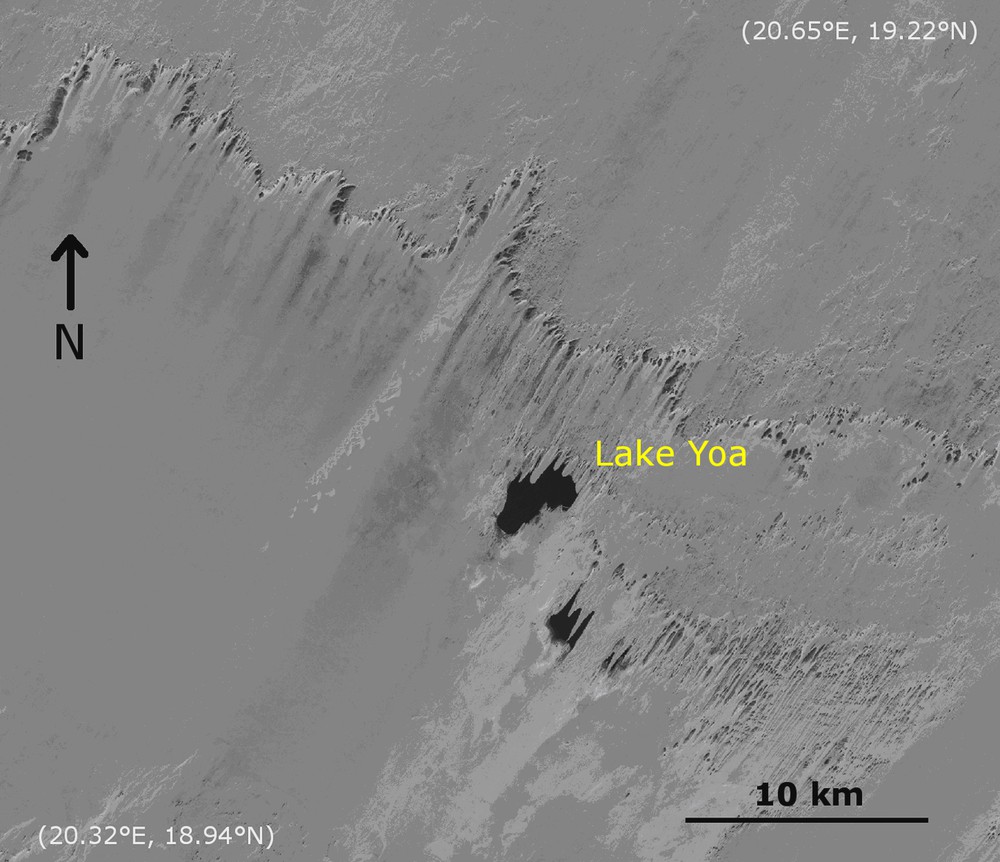
Local view of the Ounianga Kebir region (Landsat view).
Fig. 2. Vue locale de la région des lacs Ounianga Kebir (vue Landsat).
The Ounianga lakes are fed by underground water originating from the regional Nubian Sandstone Aquifer System (NSAS). Several studies focus on various parts of the NSAS for various water resource issues, i.e., the Sudanian [29] or Egyptian [28] studies. This aquifer covers roughly 2 million km2, ranging over Libya, Egypt, Sudan and Chad [9,11,19,31]. It consists of continental sandstones and intercalation of shales and clays of shallow marine and deltaic origin. To the south, east and west, the aquifer is bounded by basement outcrops. In the southwest, the sandstone layers outcrop at the rim of the Chad basin. It was last recharged during various humid episodes at the beginning of the Holocene period (African Humid Period [AHP]) [15,22]. This fossil fresh water globally discharges from the geological sandstone units into lower topographical locations. Consequently, the origin of this water is local, corresponding to recharge in the Early Holocene period (confirmed by water dating in other locations in the NSAS [Kufra and Faya] [19,31] and estimates of water velocity [11,19] corresponding to less than 1 m/yr). The regional groundwater flow trend from higher to lower zones resulting in a NE–SW piezometric head gradient in the central Erdi region has been inferred from heads measured in oasis and wells [19,31]. A flow divide is located roughly along the Chad-Libyan border (refer to the red line in Fig. 1) with decreasing piezometric levels to the north and the south. This aquifer most probably connects through other geologic formations with the Bodélé depression through the Faya-Largeau region [31] with lower piezometric heads. As shown below, analyzing the regional topography, surface water discharge also occurred in the Bodélé depression. Consequently, the Erdi unit corresponding to the lower part of the Nubian Sandstone Aquifer connects with the Mega-Lake Chad defined by Schneider [31].
The Tibesti, the closest massif, is relatively humid compared to its surroundings due to its mean high altitude (for example, a total area of 25 × 103 km2 is above 1500 m asl). Permanent soil humidity is evidenced by palm groves located in some valleys. Recently, the rainfall on the Tibesti is 12 mm/yr for Bardai station (North Tibesti), 50 mm/yr for Zouar (Southwest Tibesti) and 80 to 100 mm/yr for higher altitudes [31]. Annual and 10-year floods are reported. These generally happen in August, corresponding with monsoon southern regimes and can lead to floods extending over tens to hundreds of kilometers (centenial events). The Zoumri-Bardagué-Arayé river system for instance had, at its maximum, an extension of 350 km, exporting sediments to the north. However, AMMA-CATCH [2] reports about rainfall at Zouar accounting for secondary meteorological patterns. Indeed, over the 1948–1957 time-period, monsoon rains accounted for 78% of the rainfall events while 6% correspond to cold season rains and 16% occur in May. Jäkel [12] studied the paleo-evolution of the climate in the Tibesti from 16 kyr BP onwards, based on geomorphological terrace reconstructions and sediment studies, mainly located on the northern edge of the Tibesti, including the river system and the related playa region. Various humid phases are recorded for a maximal phase between 10 and 8 kyr BP corresponding to simultaneous reduction of Mediterranean humid air masses from north to south and an increase of tropical humid air masses from south to north. This made the Tibesti an intermediate position between Mediterranean and tropical monsoon influences. For the time range considered in this study, Jäkel [12] reconstructs two humid oscillations including a relatively warm and humid phase, probably between 6000 and 5000 cal yr BP. Then, at 4800 cal yr BP, a very arid episode is recorded including the development of dunes. Fluvial sedimentation restarted at roughly 4500 to 3700 cal yr BP. Around 700 cal yr BP, the aridity reached a level comparable to the present climate. Maley [20] reports climate reconstruction from outcrops of lacustrine deposits at Trou au Natron, a depression located in a volcanic crater, with a depth of nearly 1000 m with dried salt at its bottom. Studies show various lacustrine phases (around 15 Kyr BP). For the Holocene period, lacustrine phases are found during the periods 10 200–8700 cal yr BP and 8000–7400 cal yr BP. Pachur [23] studies paleo-drainage systems in the surroundings of the Tibesti Mountains. A review of dated lakes sediments and terraces shows that the Tibesti Mountains were surrounded by lakes in the Early Holocene while some of the paleo-drainage system were still active in Middle Holocene. Thus, clear signatures of precipitation are recorded in the Tibesti throughout the Holocene. Nevertheless, the Bardai region detailed by Jäkel [12] to the North of the massif is presented by Schneider [31] as being less favored for rain than the southern slope of the Tibesti, recording annual floods. No specific mention was found of the southeastern part of the massif which is relevant for the Erdi plateaus and the Ounianga lakes.
3 Reconstruction of the paleo-hydrology of the Ounianga region
In this study, reconstruction of paleo-hydrology is intended for 6000 yr BP conditions, the beginning and more humid part of the sequence analyzed by Kröpelin et al. [15]. Nevertheless, conditions appear already semi-arid, including rainfall estimates of 250 mm/yr, typical of an open grass savannah, with tropical and high altitude vegetation probably located along water courses. Due to altitudinal gradients, the level of rainfall over the Tibesti Mountains is probably higher, partially feeding these rivers. Most probably, surface water flow conditions in low lands already tend to be typical of arid environments. Such conditions correspond to spatially and temporally variable precipitations resulting in abrupt flood events [36]. Such systems are spatially and temporally highly variable and not easy to predict or reconstruct. Moreover, no geomorphological field study of the Holocene terraces corresponding to fluvial activity is reported in the literature for the Erdi region. This is probably due to eolian activity. This is precisely the other point that makes the reconstruction difficult: eolian erosion removed the paleo-soils and, to a limited extent, the sandstone landscape, while sand deposits cover and hide other parts of the landscape. Therefore, water network reconstruction is a challenging task, necessarily bearing some level of uncertainty.
The topographic dataset used to reconstruct the paleo-hydrology is the Shuttle Radar Topographic Mission data (SRTM) launched in February 2000. The SRTM3 package was considered, corresponding to three arc seconds, roughly 90 m. The SRTM presents minor drawbacks but interesting advantages, since the studied zone is devoid of vegetation, which classically leads to difficulties in the interpretation of altitudes. Moreover, a radar technique is likely to provide access to the topography below eolian sand deposits (limited to a metric scale) that is supposed to be the closest to the paleo-conditions (e.g. [28,29] for the Kufra region). In our study, access to the SRTM1 package (one arc seconds grid, roughly 30 m) has been provided locally where detailed information was required. It is worth addressing here the issue of SRTM topographical accuracy and including the feedback from authors using topographic data for hydrological purposes and assessing the limits of the approach. The accuracy of elevation for SRTM given in its specifications is 16 m (linear error at 90 percent confidence). The SRTM3 dataset used here is obtained averaging the nine data points from SRTM1 (one arc second), providing a better accuracy through white noise filtering. Moreover, accuracy assessments of this dataset against DEM or GPS measurements can be found in the literature, including their impact on hydrological modeling (e.g. [6,21]). Results show that for the studied sites (regional studies), the accuracy mainly depends on the land cover (impact of vegetation), slope orientation, and height of relief. Quantitative measurements of the accuracy range from 3 to nearly 10 m with some identified local features that lead to larger discrepancies, notably the steep slopes. In general, the accuracy is better than the 16 meters stated in the specifications. Unlike other studies, Rodriguez et al. [30] consider errors on a global basis. They provide a global assessment of the SRTM data against reliable GPS transects in various parts of the world. Results for Africa are included: the absolute elevation error (90 percent confidence) is 5.6 m; furthermore, absolute geolocation error is 11.9 m (in the horizontal plane). Nevertheless, the GPS transects, considered the most reliable by these authors for assessment, were not conducted in Chad. Finally, applied to the Ounianga region, an accuracy of some meters is considered (generally lower than 5 m) and should be expected throughout the domain. Major errors corresponding with cliffs (steep slopes) are not an issue because they are easily localized. Detailed reconstruction of paleohydrological channels on plateaus (nearly horizontal zones) is probably more problematic. This is detailed below.
As presented in section 1, the studied region covers a wide range of altitudes. Fig. 3 shows the SRTM elevation dataset (240 to 3340 m asl) for the larger zone (15E-25E; 15N-25N) i.e. roughly 1100 km × 1100 km. The Tibesti is located to the west with the larger depression of the region (the Bodélé depression with a large zone below 200 m asl) to its South. To the southwest, the other mountain massif is the Ennedi (max. alt. 1450 m asl). Between the Tibesti and Ennedi Mountains, the Erdi plateaus contain the Ounianga lakes with Lake Yoa at 379 m asl (the dot in Fig. 3). Their altitudes globally decrease from north to south (Fig. 3). Locally, on Lake Yoa plateau, the topography is close to flat with a depression where the lake is located. The frame in Fig. 3 delineates the limits of the zone, referred to below as the local model (Figs. 4 and 5).
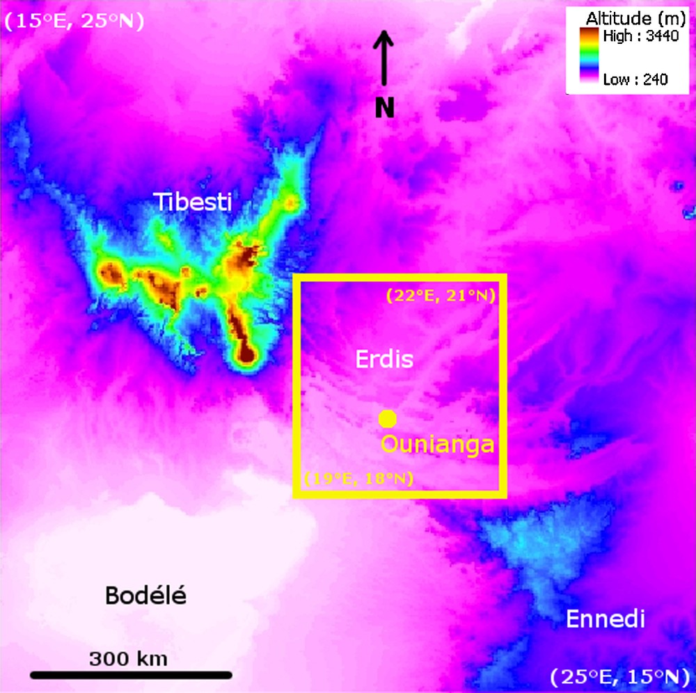
Altitudes of the region from the SRTM dataset (15E-25E; 15N-25N), the frame delineates the limits of the zone referred below as the local model (Figs. 4 and 5).
Fig. 3. Altitudes à l’échelle régionale à partir des données SRTM (15E-25E ; 15N-25N), le cadre correspond aux limites du modèle local (Fig. 4 et 5).

Altitudes and water network in the local model (19E-22E; 18N-21N).
Fig. 4. Altitudes et réseau hydrographique à l’échelle locale (19E-22E ; 18N-21N).
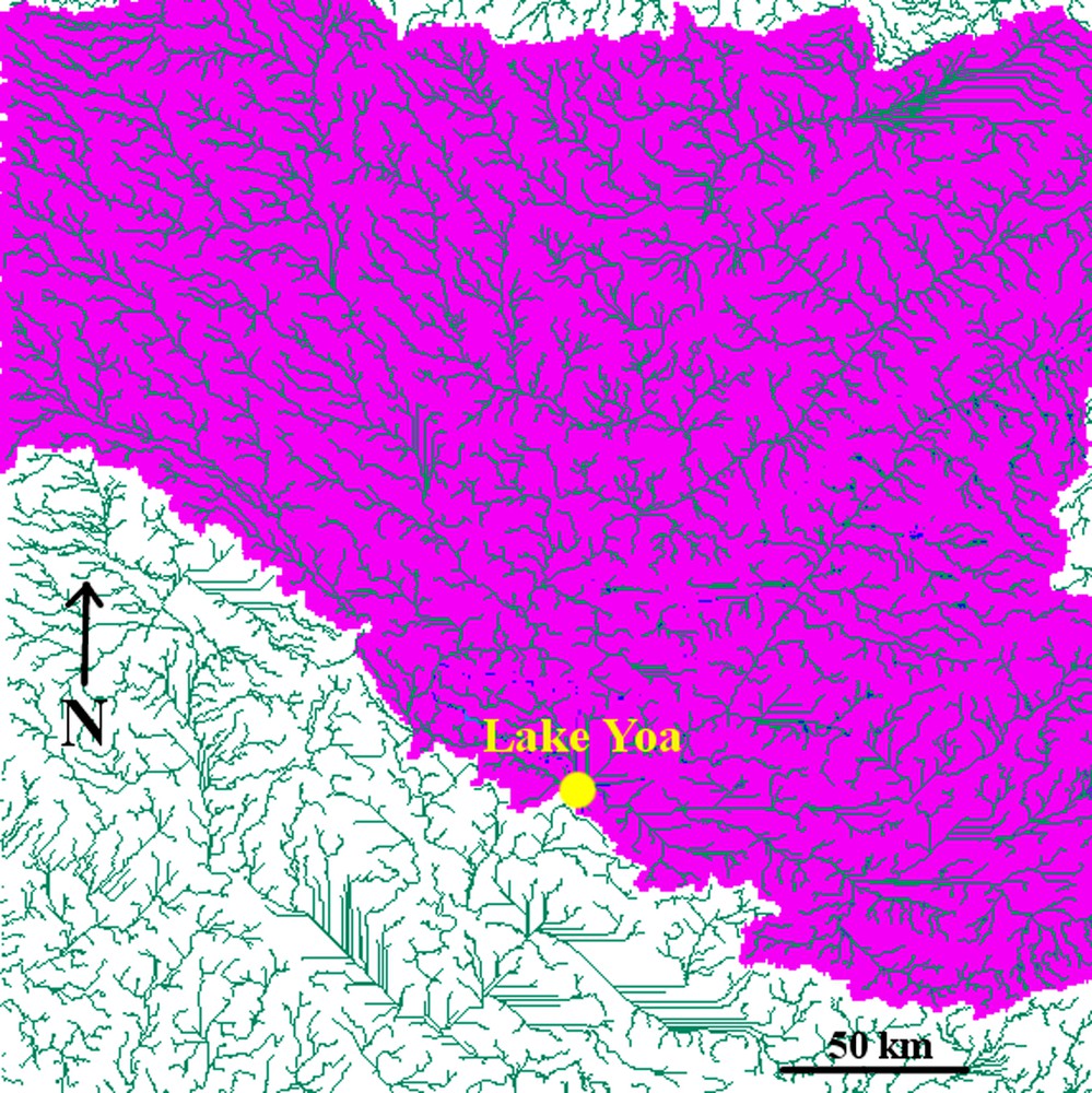
Catchment area of Lake Yoa in its maximal extension (19E-22E and 18N-21N zone).
Fig. 5. Bassin versant du lac Yoa pour son extension maximale (fenêtre 19E-22E et 18N-21N).
The surface hydrology has been reconstructed based on this topography with the ArcGIS software [3]. Streams corresponding to lines, drawn following the lower topographic positions, and catchment areas corresponding to Lake Yoa are final outputs of the computation. Intermediate steps include topographic and slope treatment, computation of flow directions from slope orientations, and flow accumulation zones. The Ounianga region was analysed studying numerous zones and extensions. The main results for the local model (the frame in Fig. 3) are reported below.
Results for stream lines are provided in Fig. 4 and for the associated water catchment areas in Fig. 5. Stream lines mainly follow very distinctive valleys for the northern, eastern and western part of the domain. At the plateaus, the situation is more difficult to interpret since stream lines are present on close to horizontal reliefs where the actual path depends upon local and weakly-contrasted topographical gradients. Due to the gentle slope to the north, stream lines are closer to the cliffs than the edges while leaving the plateau through more or less distinct valleys. The total water catchment area is large (Fig. 5), accounting for 67,300 km2 (from which 18,600 km2, i.e. 28% of the total, is relative to Tibesti Mountains).
In any case, results show that the lake is situated in a very favorable position to receive surface water from local rainfall (downstream from most of the Erdi plateau) while it also drains some water from the Tibesti massif to the North-West of the domain. The flow paths from the Erdi plateau distinctively follow valleys (Fig. 4) constituting stream networks progressing down-slope globally from north to south. The relation of Lake Yoa to the Tibesti massif corresponds to distinct valleys descending along the Tibesti slopes joining to the west the first plateau above the actual plateau where Lake Yoa is situated (Fig. 4). Further downstream, the stream lines follow low altitudinal gradients and more complex geometrical patterns. After careful study of the topography, considering the uncertainties associated with the SRTM dataset, these paths were considered to be most plausible. This is in agreement with pollen records, i.e. the surface water connection of Lake Yoa with the Tibesti providing high altitude taxa in the lake sediments back at 5000 yr BP (section 2). It should nevertheless be mentioned that one critical location is found along the path from the Tibesti to Lake Yoa. At location (20°2′E, 19°6′N), labeled A in Fig. 4, the stream lines leading to Lake Yoa and those descending to the south (not leading to Lake Yoa) lie within a distance of 400 m. Careful examination of the topography confirms that the flow lines drawn by ArcGis are in agreement with the topography. According to the literature [30], relative elevation precision should be good, even optimal in flat areas. But the altitudinal differences here are small, on the order of some meters, within the accuracy uncertainty of the SRTM. Moreover, the surface considered is probably not quite the paleo-surface due to the fact that the soil has been transported away by eolian erosion. More precisely, the situation on this plateau corresponds to a gentle slope oriented southeast, i.e., oriented to the east (1.5% to the lake) and a similar although smaller slope to the south (1.1%). The probability that a full south direction is selected by the flow is low but it would head toward a valley clearly visible between its cliffs. A source of improvement was expected from satellite images. But Landsat images could not clearly support or refute this result. They generally only provide access to the present-day surface mostly covered by sand dunes. More recently, PALSAR L-Band data from the Japanese ALOS satellite was obtained locally. It corresponds to a 50 m grid dataset and runs in L-Band reaching deeper into the sand cover. The picture (not provided here) shows distinct network patterns starting northwest of Location A (the next valley cut in the cliff to the west) and corresponding to an alluvial fan of the Okavango type (modern analogue). The situation for Location A does not provide similarly clear trends. It is located downhill from another alluvial fan, less pronounced and appearing to consist of two groups of units in two major directions: to the south and to the east. This confirms that both directions are actually possible and were probably jointly active in the past. For definitive conclusions, complementary geomorphological studies should be conducted.
Comparison with other results provides global confirmation of maps in this study though local discrepancies exist. For instance, the map by Pachur and Hoelzmann [25] was considered. It shows paleo-drainage systems and paleo-lakes but is conducted at a much larger scale, roughly the whole eastern Sahara (square of 1500 km side where the Ounianga region is located on the lower left part). Their results are presented as resulting from ground mission research and satellite image interpretations without further precisions. The Ounianga region is not detailed but the sketch provided differs in terms of the relationship between the Tibesti and Ounianga regions, since stream lines turn to the south earlier and do not reach Lake Yoa (even earlier than Location A mentioned previously). This is confirmed by Pachur [24] where the Ounianga lakes are described as independent from water supplied by discharge from the Tibesti Mountains. In our study, this is true for Ounianga Serir, 50 km east of Lake Yoa, but not for the latter. The same outlet is nevertheless found, the Bodélé depression. So, the general picture is identical but some smaller-scale features differ. Similarly, they find no connection between the Ennedi massif and the Ounianga lakes. Indeed, water from the north Ennedi is drained by the Mourdi depression and flows to the southwest.
4 Preliminary water budgets
Fig. 6 provides a local view of Lake Yoa (roughly 36 km side). The lake can be recognized in the central higher part of the picture (compare with LANDSAT picture, Fig. 3). Lower altitudes are presented by darker levels of grey. Closer analysis of the topography around Lake Yoa shows that higher lake levels are possible up to a topographical threshold at 419 m asl, i.e. 40 meters above present (compare with present level at 379 m asl, Fig. 6). The associated maximum lake surface is 320 km2 (compared with 4.3 km2 today). This situation is illustrated in Fig. 7, representing exactly the same region as in Fig. 6. The lake level difference with the present is 40 m and compares well with other lake level changes reported in the literature in the Saharan region (refer for instance to [8,25,33]).

Local view (topography and stream lines) at Lake Yoa (0.32° wide, roughly 40 km).
Fig. 6. Vue locale du lac Yoa (topographie et figures d’écoulement (largeur 0,32°, environ 40 km).

Threshold at 419 m asl, potential lake surface.
Fig. 7. Niveau seuil à 419 m asl, surface potentielle du lac.
A preliminary water budget is attempted here for the case of 6000 cal yr BP. This time period corresponds to the base of the sequence analyzed by Kröpelin et al. [15] with the most humid period of the measured sequence. The water conditions for the lake are dominated by river inflows as acknowledged by the presence of high altitude pollens in the sedimentary archive of Kröpelin et al. [15]. The question addressed here is whether or not the lake level has reached its maximum level at the threshold of 419 m asl. Nevertheless, some terms of the water budget are highly uncertain as discussed below. The approach is, first, to propose a preliminary and tentative water budget indicating the probability of a high lake level and second, to identify the terms of the budget that should be improved and to propose a strategy to obtain this improvement.
The variation in the lake volume is related to inputs from P (precipitations), RI (rivers), GWI (groundwater) and outputs corresponding to E (evaporation), RO (river), GWO (groundwater), for an equilibrated lake level (steady state conditions), inputs and outputs are equal: P + RI + GWI = E + RO + GWO. The starting point is the present lake budget. No surface flow is observed, thus RI and RO are zero. The evaporation rate is roughly 6 m/yr for a lake surface by 4.3 km [15] yielding a water uptake from the lake (GWI – GWO) equal to 0.818 m3/s.
According to Kröpelin et al. [15], at 6000 BP, the landscape corresponds to an open grass savannah including some tropical herb species and Sudanian trees probably located along wadis. The precipitation is estimated to be close to 250 mm/yr. This is slightly lower than the level of 400 mm/yr reconstructed by Liu et al. [18] at 6000 BP with a coupled ocean-atmosphere-terrestrial ecosystem GCM for the 18–23°N/11–34°E sector. In the present study, the evaporation rate over the lake is estimated to be roughly half the present rate (3 m/yr) accounting for the fact that strong northeast trade winds developed later, by 2700 BP [15]. The groundwater contribution to the budget is taken from the study by Heinl and Brinkmann [11]. They model the Nubian Sandstone Aquifer's pure discharge regime from humid initial conditions (8000 BP) to present arid conditions. Their results show that the discharge rate from the aquifer to the depressions only records minor variations. Accordingly, here it is assumed that (GWI – GWO) is twice the present-day value computed above. The resulting river inflow that balances this for the maximum lake surface corresponding to the threshold lake level conditions (320 km2) can be expressed into mm/yr by dividing the flow rate by the water catchment area S (67,300 km2). The required run-off is 12.3 mm/yr. The required run-off for the sole portion of the water catchment area relative to the Tibesti (18,600 km2, i.e. 28% of the total) would be 44.5 mm/yr, roughly four times larger.
The total river inflow results from a complex interaction of surface and sub-surface flows throughout the catchment area, generally depending on the levels of precipitation, evaporation, vegetation cover, soil and geological medium properties, topographical features, as well as the water mass repartition (soil moisture, water heads in the underground system) and correlatively precipitation history. Knowing that the present arid conditions do not allow for direct measurements of these features, one must rely upon reconstruction strategies from poorly constrained parameters. The river input rate (RI) can be written relative to the surface of the catchment area as follows: RI = a (P – E – T) S, where P is precipitation, E, evaporation, T, transpiration, S, the catchment area, a, the transmission coefficient of the flow rate along the river courses (accounting for transmission losses).
Two sources of information are available for E and T: climate modeling results or measurements carried out at other sites presenting analogous features. The Paleoclimate Modeling Intercomparison Project, Phase II benchmark (PMIP II [26]) provides a comparison of eight global climate models for several temporal snapshots (present, 6000 yr BP, 12 kyr BP). Considering yearly (precipitation – evaporation) budgets at mid-Holocene (6000 yr BP) for a spatial window of 3° around Lake Yoa, the median over all models is 346 mm/yr (a mean of 440 mm/yr) for (precipitation – evaporation). However, values obtained over all models range from – 1.88 to 1002.60 mm/yr meaning that the predictability is rather limited. The usefulness of such simulations is in fact limited by the grid size of the models (roughly 200 km) which is too rough compared to the scale of the Ounianga region and some limiting modeling options (very simple soil bucket model for instance). Recent simulations by Liu et al. [18] including vegetation change provide full transitory simulation results over the Holocene for a large 18–23°E and 11–34°N zone (section 1). Sepulchre et al. [34] uses a locally refined grid (roughly 50 km) over the lake Chad catchment and provides a snapshot at 6000 yr BP. The level of precipitation is here contrasted between mountainous and low-land areas, and the Erdi plateaus receive roughly 100 mm/yr [Sepulchre, personal communication]. Due to similar levels of evaporation, the difference between precipitation and evaporation rates is below the estimated precision limits and therefore not representative. The other source of information favored here corresponds to measurements campaigns carried out in analogous environments. Considering the 6000 yr BP period for Lake Yoa corresponding to semi-arid open grass savannah and a precipitation rate of 250 mm/yr, modern analogues can be found several hundreds of kilometers to the south, in the African Sahelian region. The HAPEX Sahel project (Hydrology-Atmosphere Pilot Experiment in the Sahel, 1990–1992) [10] and more recently the Analyse Multidisciplinaire de la Mousson Africaine – Couplage de l’Atmosphère Tropicale et du Cycle Hydrologique project (AMMA-CATCH) [2], study the soil-vegetation-atmosphere interface. They provide similar conditions and good constraining levels on the hydrological budget. At the Hombori site (15.3°N, 1.5°W, Mali), consisting of grass with sparse trees, the annual rainfall reported in 1992, 1993, 2000 are in the range 276–306 mm/yr for evapotranspiration rates varying between 85 and 96% of rainfall [13]. For 1999, recording large yearly rainfall (521 mm), the evaporation rate is by 43% of the total rain. In the Wankama catchment (13.4°N, 2.4°E, West Niger) [27], recipitation measured in the period from 1992 to 2006 are higher (300–600 mm/yr). The studied year 2006 provides 572 mm/yr of rainfall for 66% of cumulative evapotranspiration for a fallow site.
Based on previous analysis, a ratio of 90% for normal to dry years appears to be rather conservative. This means that roughly 25 mm/yr (10% of the 250 mm/yr) remain for run off and infiltration. Following the results of the modeling of the Nubian Sandstone Aquifer by Heinl and Brinkmann [11], relative to their initial semi-arid steady-state conditions, the water table appears to be probably rather close to the surface at 6000 BP. They show indeed that steady state conditions with maximum water levels are obtained for low values of recharge (1 mm/yr for the Erdis and a maximum of 15 to 20 mm/yr on the Tibesti). Consequently, the water table is probably high enough to allow net runoff and exfiltration larger than infiltration, and low transmission losses along the rivers. Tooth [36] reviews the situation of arid climate rivers throughout the world and shows the impact of overall transmission losses (infiltration of floodwaters, evaporation, ponding in terminal storages) on their flow rates. Results (including rivers systems with lengths ranging in the hundreds of kilometers) show that they vary between 40 and 90%. Considering a transmission coefficient of 50% as a conservative value, it leads to an effective river input of 12.5 mm/yr for the whole catchment area (67,300 km2). This value resulting from conservative assumptions compensates the losses computed formerly in the lake water budget for its maximal extension (12.3 mm/yr). Consequently, it is probable that the lake reached its maximum level at 6000 BP, being at that time an open system (exorheic surface system with a river outflow) renewing its waters. This is in agreement with the analysis by Kröpelin et al. [15]. This estimation is conservative from another important point of view. Rainfall estimates from Kröpelin et al. [15] probably describe the situation around Lake Yoa while rainfall over the Tibesti Mountains (28% of the water catchment area) providing distant recharge to the lake are probably larger.
This computation relies upon poorly constrained parameter values and conditions. Improvements are looked for along an ongoing transitory hydrogeological modeling of the southwestern part of the NSAS. Better control on the surface conditions and terms of the budget are expected from refined climatic modeling dedicated to this issue and multidisciplinary discussions on the Lake Yoa sedimentary archive. The altitudinal dependence of rainfall (Tibesti zone) should be studied or estimated.
5 Conclusions
This study presents a first attempt to include local hydrological features and to bridge them together with the proxy data and global climate modeling results, in an effort to arrive at a better understanding of the climate evolution of the Ounianga region. It clearly demonstrates the necessity to include the influence of small-scale features in climate reconstruction. Among these, hydrological and hydrogeological patterns that contribute to maintain humid conditions, at least locally, increasing the length of transition periods from relatively humid to arid conditions. Rivers or wadis also transport pollens. The study clearly confirms that Lake Yoa is situated at a very favorable location because its catchment area is large. Moreover, the connection of surface water with the Tibesti has been shown to be highly probable, sustaining the results from sedimentary records at 6000 yr BP when high altitude taxa are found. Furthermore, the study is demonstrative of the necessity to bring together local information from outcrop analyses, local modeling of water, as well as global climate modeling to try to quantify the climatic conditions or at least to discriminate between various scenarios in spite of the large remaining uncertainties. In this respect, the present study shows that quantitative reconstructions are still difficult to obtain based on the current data. This is due firstly to the large variability of the climate modeling results for the mid-Holocene period (PMIP II and others). Difficulties in discriminating between various quantitative humidity scenarios show that improvements are required in these models, possibly from more dedicated climate modeling exercises (e.g. focusing on the region). The second factor is the current level of hydrological modeling itself. Although other authors have recently had successful results using the SRTM dataset in some favorable regions and at a larger scale, in particular, the surface water stream reconstruction from this data confirms here the results of the sedimentary analysis in the Lake Yoa, but suffers from larger uncertainties in the Ounianga region due to its flatness in relation to the accuracy of the SRTM data. A complementary geomorphological study of the site, for instance, would be profitable to arrive at a more definitive answer. Groundwater from the NSAS provides another source of long term water discharge in the region. Hydrogeological modeling of the NSAS is ongoing and should help in constraining the inflow from the aquifer to surface water bodies and regionalize its impact.
Acknowledgements
The study was granted by the French ANR (Agence nationale de la Recherche) within the SAHELP (SAhara and SaHEL vulnerability: lessons from the Past) project. It benefited from the results obtained at Lake Yoa within the ACACIA [1] project. The authors gratefully acknowledge discussions with A.-M. Lézine, S. Kröpelin, D. Verschuren, P. Braconnot, W. Zheng, P. Sépulchre, remarks from the anonymous reviewers, and linguistic improvements from J. Calkins.