

1 Introduction
The Ja’alan (Fig. 1), the easternmost province of the Sultanate of Oman, is described by geographers as an arid desert [5].
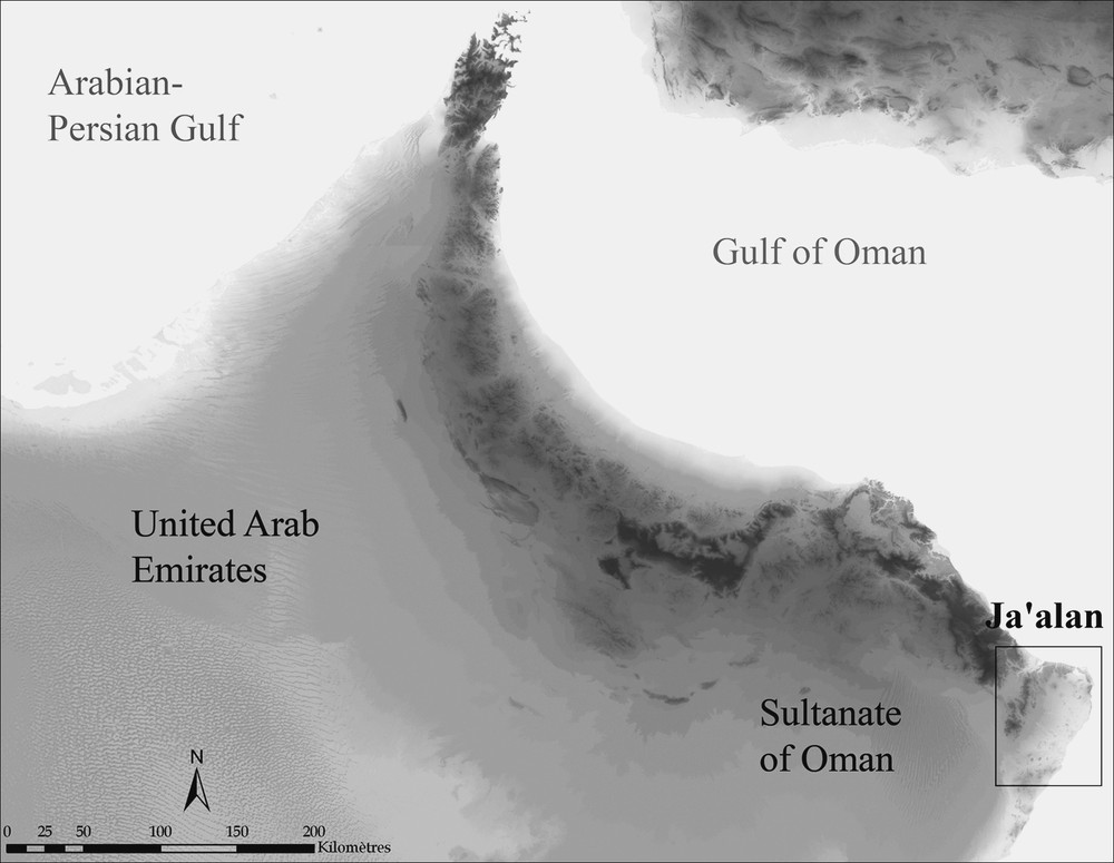
Location of the province of the Ja’alan (Oman).
Fig. 1. Localisation de la province du Ja’alan (Oman).
The term arid derives from the intrinsic geographical and climatic characteristics of the area. The denomination “desert” comes from the fact that this area was considered sparsely populated. Today, however, this area is not empty, and archaeology has demonstrated that it has been populated for a long time, especially from the beginning of the Early Bronze Age.
The present study considers this situation, from archaeological data obtained mainly for the Neolithic and the Early Bronze Age, as these periods are clearly defined, and as the area was surveyed, on and off, over more than 20 years as part of the Joint Hadd Project directed by Serge Cleuziou and Maurizio Tosi. These surveys have been intensified since 2002 under the direction of the author.
Through a GIS study including the 4000 archaeological structures found, it has been possible to evaluate the spatial distribution of the sites for each main period, and to observe the variation in the settlement patterns. It is now possible to outline the territorial dynamics over several millenniums. Some changes in the morphology of the region have also been detected and can be matched with variations in sea levels and climatic change.
The main goal of this short article is to show how we can reconstruct the geographical space of a vanished population. The study of the present situation is necessary in order to understand environmental and human dynamics of arid areas. We also have to reconstruct the geography and the environment of the areas in the past to define the exact relation between societies and their environments. In arid regions, the social dynamics are read through spatial distributional patterns.
2 The environmental context of the province of the Ja’alan: an arid region with various landscapes still currently populated
2.1 Climatic feature: an arid area
The whole Oman Peninsula is described as an arid region [5]. This is due to climate, biogeography and morphogenesis. The main signs of aridity are low and irregular precipitation concentrated in winter, strong drought and significant evaporation.
In the Ja’alan, the rainfall is less than 100 mm/year. The precipitation system is trimodal: there can be rain during the winter and/or the spring (between November and May); 9% of the rains occur in summer.
The area is situated in the convergence of the northern limits of the monsoon rains and the southern limits of the cyclonic rains. Both types occur, but in much less, and in irregular ways. Even the temperatures are high and the thermal amplitude is wide. Summer is hot, even along the coast.
2.2 Environmental features: an arid region, several varied landscapes with different uses
The Ja’alan consists of several different environments. There are various ecosystems in a quite restricted area: mountains, large dissected Quaternary terraces, wide wadi beds, fossil or still active lagoons, rocky and flat sandy coasts (Fig. 2). This distinctive area is defined by geographers, but the inhabitants differentiate and named only five different environments (Fig. 2): el-Bahr (the sea), el-khawr (lagoons and bays), es-Sahel (sandy areas), el-Jabal (rocky areas) and el-Wadi (river areas). The variety lies in the different activities performed in these areas [9].
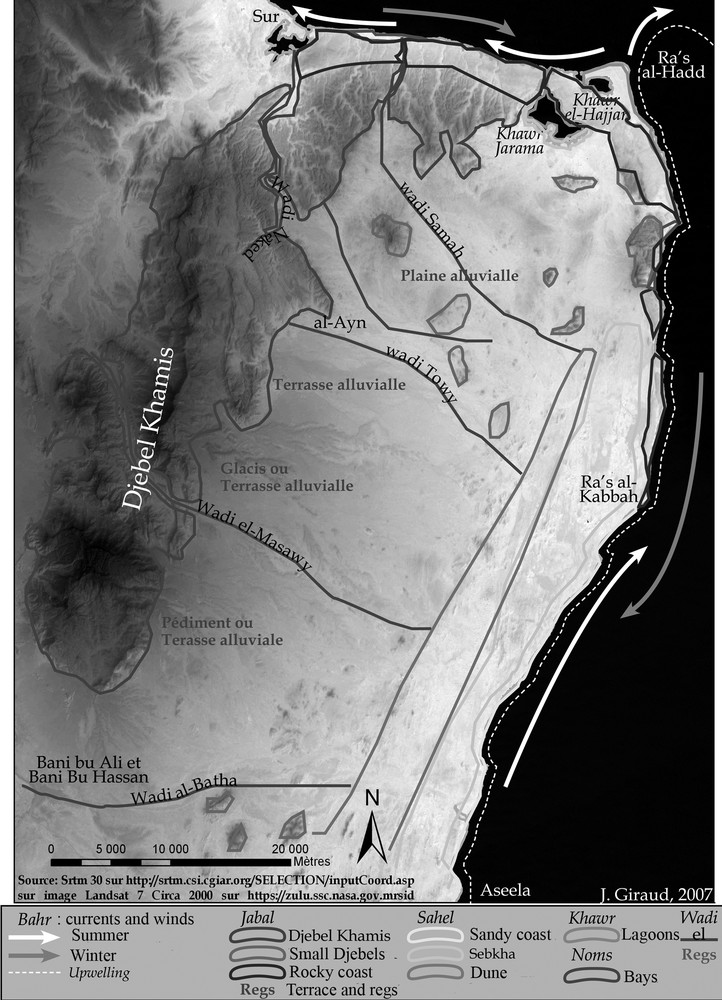
The different environments exploited by Bedouins. Legends: el-Bahr: currents and winds, white arrows: summer current, grey arrows: winter currents, white pointed line: upwelling fact // el-Jabal: Djebel Khamis, Small Djebel, Rocky Coast, Terrace and regs // es-Sahel: Sandy coast, Sebkhas, Dune area // el-Khawr: Lagons, Bays // el-wadi)
Fig. 2. Les différents milieux exploités par les bédouins (Légende : el-Bahr : courants et vents, flèches blanches : courant d’été, flèches grises : courants d’hiver, ligne pointillée blanche : zone de l’effet d’upwelling // el-Jabal : Djebel Khamis, petits Djebel, côte rocheuse, terrasses et regs // es-Sahel : côte sableuse, sebkhas, zone dunaire // el-Khawr : lagunes, baies // el-wadi).
El-Bahr, the sea, is the main resource. The main characteristic of marine traffic in this region of Ja’alan is that winds and currents change 180 degrees [2,6], following the summer monsoon SW winds, which appear in summer. In winter, winds and currents move in a general north-south direction and during summer they change for a south-north direction. During winter the current is very low. These processes have a direct impact on human activities. In summer, fishing is impossible: the winds and currents are too strong and the sea can be dangerous. On the contrary, during winter, the sea is navigable and halieutic resources are very important due to the upwelling phenomen linked to the monsoon (rise in cold deep waters that have the characteristic of being rich in phyto- and zooplankton).
El-Khawr combines lagoons and bays along the coast. In the Ja’alan this concept concerns the northern area that includes a number of coves and bays embedded in high rocky terraces and two coastal lagoons: Khawr Jarama and Khawr al-Hajjar. All of these bays are used for traditional fishing. Vegetation consists only of the mangroves that surround the lagoons; Avicennia marina relict is still visible on the lagoon Khawr Jarama.
Es-Sahel is defined by all the sandy areas. It can be sandy coasts, sebkhas and dune areas. In the Ja’alan, this environment is organized into three north-south bands. Long coastal strips develop in the east. This area was previously occupied by arrows of ancient lagoons, and retained a system of inland lagoons [1,6]. These lakes have disappeared, so the arrows have transformed into dune cordons. To the west of the dune system, one can note a parallel system of sebkhas in development. They were old lagoons that have slowly dried up after the silting of their channels [1]. After an important rain, a closed “lagoon” can be formed and lasts for several weeks or months. In those cases, some vegetation grows, making ephemeral grazing possible. Parallel to these sebkhas, a dune area stretches for several kilometers.
El-Jabal includes all stony and rocky areas. These are the coastal terraces north of Jebel Khamis in the west, alluvial terraces, terraces, pediments and maze of central and southern foothills, and also the Hawasina hills and inner small hills that are also located throughout the area. The vegetation consists mainly of Acacia sp. xerophytic and shrubs. The main activity is pastoralism. Some gardens of date palms near the wadis are also presently exploited.
El-wadi refers not only to the wadis themselves, but combines the wadi beds and their major and minor valleys and alluvial plains. In the Ja’alan, this environment is structured from east to west from five major wadis. Other wadis are shorter and only structure the nearest environment. The wadis of Ja’alan are endoreic. The plain is mainly a steppe, with a few Acacia sp., and wadi beds are characterized by a little more concentrated vegetation consisting mainly of Acacia sp. and Prosopis sp. often located in very sandy areas, which can be places for pasture.
2.3 The actual settlement pattern
Despite the fact that we are in a very arid area, the region is still quite populated. We can define several types of settlements associated with different activities: the big oasis on south (Bani Bu Ali, Bani Bu Hassan) fishermen villages on the coast (es-Sahel, el-Bahr), inland village, and sporadic village created to settle Bedouins in el-Jabal with small oasian gardens in el-Jabal and el-Wadi, and nomadic village of the Bedouin in el-Jabal and in el-Wadi where pastoralism is possible.
3 The historical context: 8000 years of the evolution of societies and their environment
3.1 A brief history of 8000 years of human settlement in Oman Peninsula
Although it was probably an important background, late Early Holocene remains are poorly known. The sites are characterized by concentrations of lithic pieces. The concentrations discovered attest to a rather intensive occupation near ancient lakes or ancient coasts. The economy was based on hunting, fishing and gathering.
The late sixth to fourth millennia BC are much better known [4,5], mainly through the study of coastal zones where dozens of settlements have been identified and several partly excavated or tested: Dama 11, Umm al-Qaiwain 2, Ra's al-Hamra 5, Suwayh 1, 2 and 11 and Ra's al-Kabbah. One inland site has been identified: al-Buhais 18. This “Neolithic” society does not really differ from the previous one. People were specialized in fishing or hunting marine mammals. However, animal domestication is present. The main difference with most of other Neolithic societies is the absence of agriculture. The pottery is imported from Mesopotamia (Obeid culture). All excavated settlements are composed of several circular structures as tents. Often associated with the dwellings, the graves are simple pits dug into the substrate. The tombs are mostly single but can also be collective (Ra's al-Hamra 5 and al-Buhais 18).
Most aspects of the society changed at the end of the fourth millennium BC [4] (beginning of the Early Bronze Age period). This has been observed through the complete change in funerary practices. Many tower-like collective burials were built upon the rocky ridges and are highly visible in the landscape [4,6]. Several thousand graves are known in Oman but only two settlements of this period have been found. Both are situated on the coast of the Ja’alan (HD-6, near Ra's al-Hadd and ALA-2) [5,6]. HD-6 is a complex and organized dwelling of mud-bricks buildings, and it is the more ancient village of the Early Bronze Age. Pottery and some evidence for agriculture have been discovered, suggesting the appearance of an oasian gardens system. However, only the association of date stones, palm-tree wood, cereals, and fruits can actually prove an existence of oasian gardens [14]. The date-palm tree constitutes the basis of the oasian culture, firstly because of its own characteristics and nutritional advantages, and secondly because its height and its foliage provide a habitat for cultures that need some humidity and shadow, such as cereals, legumes and fruit-trees [14]. This system can be settled even where water is very limited, with a good yield. During this period, this system is only well attested at Bāt, and it is developed mainly during the second part of the third millennium BC [14].
In the middle of the third millennium BC some burials with increasingly complex rituals appear [4]. These graves are no longer situated in the highest parts of landscape, but are mainly located closer to the settlements, often in the plain [6]. These settlements are better known and several have been excavated, Umm an-Nar, Ra's al-Jinz, Hili, Tell Abraq, for example. During this period the oasian system is very probable. The association of stores, grains and wood has been found in Hili, Tell Abraq and Ra's al-Jinz. After this period, settlements, graves and society change from the beginning of the Middle Bronze Age ca. 2000 BC (Wadi Suq Period).
The province of Ja’alan follows this general Oman Peninsula evolution, with coastal Neolithic sites, cairns and tower-like burials of the first part of Early Bronze Age, and larger burials and settlements of the second part of Early Bronze Age.
3.2 The Ja’alan, an arid or green desert?
Palaeoclimatic studies (analysis of speleothems, of isotopes; lake and marines cores) conducted over 20 years allow us to reconstruct the climate and the landscape of the Oman Peninsula and more specifically the region of Ja’alan [1–3,10,11,13,15]. The regional data and the Ja’alan data outlined here have been already developed by A.-M. Lézine and S. Cleuziou (this volume) [3,11]. So we restrict the presentation to the evolution of climate and biogeography in the Ja’alan.
The Middle and Late Holocene corresponds to a climatic optimum sometimes called the « période humide arabique » [13]. From the beginning, when humidity was not really high, the climate is becoming more and more arid until today. This climatic optimum did not have the same impact that it had in the Sahara, and it would be wrong to evoke a “green Arabia”. Because of the fluctuations of evaporation and precipitations, this area remains a semi-arid sector. The slow and progressive dryness is due to the southwards movement of the intertropical convergence area [11].
Regional studies about the evolution of the sea level indicate an important change. They show a 5 m-higher level than nowadays [1,2,11] in the Oman Gulf and the Indian Ocean. The geography of shoreline was necessarily disrupted. The coast was very different in the fourth and the third millennium BC. It was cut, and large lagoons grew up behind lagoonal arrow, and finally formed the sandy coastline. During the Neolithic period, the lagoons were well developed. But the ensuing drought triggered their regression and the formation of present-day coastal sebkhas. During the Bronze Age, lagoons were present but decreasing in size [1,11].
In parallel, palynological and anthracological studies [11,15] show that the environment was made of a steppic landscape of Acacia sp. and Rhizophora sp., with a little bit more humidity and rainfall than today. The pollen analyses show the appearance of Prosopis sp. at the end of the third millennium BC, which indicates that the zone was becoming drier [11].
4 The methodology to determine settlement patterns
The analysis of settlement patterns that are extinct nowadays demands a long multidisciplinary work. We need cross-data from several fields such as: archaeology, geography, climatology, sedimentology, archaeobotany, ethnography, remote sensing, geomatics, etc.
For this study we developed a specific research protocol [6]. This plan of article follows the different steps of this protocole. In the first step, we study actual landscape and settlement dynamics (see section 2). This study gives us an example of a pattern of dynamic societies living in an arid area. Then we have to study the history of societies (see sections 3.2 and 5.1) and the vanished landscape in order to understand the dynamics of the ancient settlements patterns in some region and their differences (see sections 5.2, 6 and 7). All those elements can only be reconstituted thanks to the cross-referencing of data obtained during surveys and excavations (see section 5.2). Finally, this cross-referencing is done throughout spatial analysis, thus enabling us to try to model the interaction that existed between society and nature in a desert environment 8000 years ago (see sections 6 and 7).
5 New data in palaeogeography and archaeological map of the Ja’alan
The data collected and study results have helped to establish a preliminary picture of Ja’alan: a semi-arid landscape which dried up, populated by a Neolithic nomadic society that seems to have settled down in third millennium BC.
Combining old and new data (surveys, recent excavations and researches by the Joint Hadd Project teams), it is now possible to present the palaeogeography of the coastal and inland regions, as well as a precise archaeological map of the whole area.
5.1 The palaeogeography of the Ja’alan: some important lagoons
The reconstruction of the coastal geography is necessary to analyze the settlement choices.
The regional rise of 5 m is locally confirmed by the micromorphological data from the sebkha of as-Suwayhs [1]. With GIS software it is possible to reconstruct a hypothetical shoreline by cross-referencing all data (Fig. 3). The large lagoons occupied the actual sebkhas [6].

Map of the reconstruction of lagoons around the beginning of the third millennium BC, with a 5 m-higher sea level than the current level.
Fig. 3. Carte de la restitution des lagunes autour du troisième millénaire avant J.-C., avec un niveau marin supérieur de 5 m par rapport au niveau marin actuel.
5.2 From the archaeological map to the spatial study of history
Since 1985, surveys and excavations discovered about 1000 structures in the Ja’alan. After intensive surveys conducted by the author between 2002 and 2007, more than 4000 archeological structures are now listed on an area of 3000 km2.
Surveys were undertaken throughout the entire area [8]. In the less accessible places, testing and transects have been made, especially into the sebkhras and the sand dunes, a part of the high mountains in the west and several wadis near the mountains.
The density of this archaeological map shows quite an important general settlement. It appears to have started at the very end of Paleolithic times and continues until today.
6 Discussion: evolution of settlements from the Neolithic to the Bronze Age
After having explored the ancient dynamics of the environment, the second phase concerns the study of the well-dated archaeological structures and their localisation. The thematic maps, all made using GIS, show obvious differences between the ways people settled during different time periods.
6.1 Neolithic settlement patterns
The Neolithic period is only represented by one hundred ill-defined structures; they are mainly concentrations of lithic artefacts.
The dating could not be precise due to the lack of good and typical artefacts (except for the excavated sites). Consequently, we choose here to show in the map only the excavated settlements (Fig. 4).
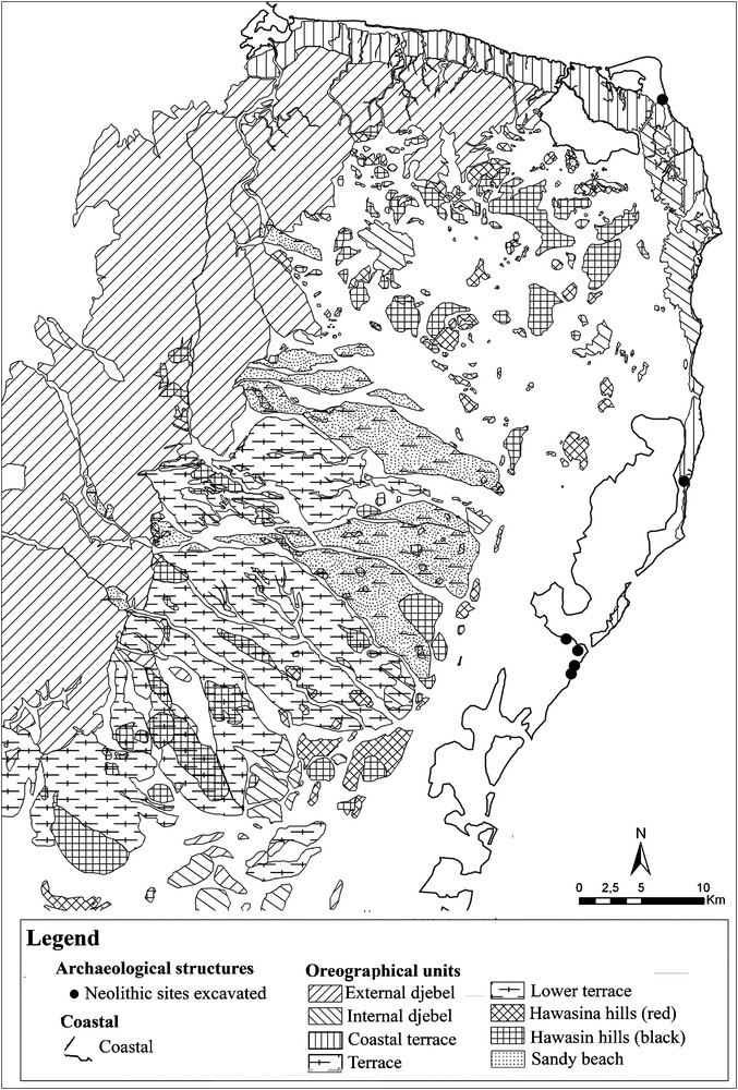
Map of the Neolithic sites. (Black circles: Neolithic sites excavated/Other legends are: Coast, External djebel, Internal djebel, Coastal terrace, Terrace, Lower terrace, Red Hawasina hills, Black Hawasina hills and Sandy Beach).
Fig. 4. Carte des sites néolithiques (Cercles noirs : sites néolithiques fouillés/Les autres légendes sont : Côte, Djebel extérieur, Djebel intérieur, Terrasse côtière, Terrasse, Basse terrasse, Collines d’Hawasina rouge, Collins d’Hawasina noire et Plage sableuse).
All are located around the ancient lagoons and on the coast. The exploitation of coastal resources and resources from mangrove swamps and lagoons was apparent, and one can observe a growing importance of deep-sea fishing.
6.2 The first part of the third millennium BC settlement patterns
During the early third millennium, the sites are more numerous and our map can be considered as almost exhaustive (Fig. 5).
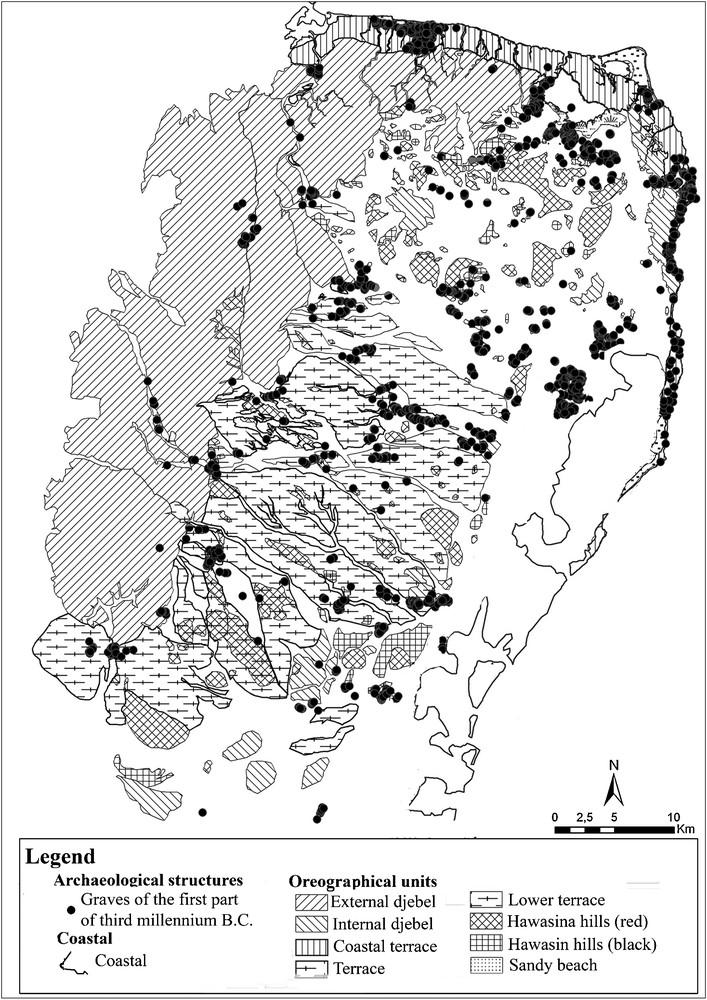
Map of the first half third millennium sites. (Black circles: Graves of the first part of third millennium BC/Other legends are: Coast, External djebel, Internal djebel, Coastal terrace, Terrace, Lower terrace, Red Hawasina hills, Black Hawasina hills and Sandy Beach).
Fig. 5. Carte des sites de la première moitié du troisième millénaire avant J.-C. (Cercles noirs : tombes de la première moitié du troisième millénaire avant J.-C./Les autres légendes sont Côte, Djebel extérieur, Djebel intérieur, Terrasse côtière, Terrasse, Basse terrasse, Colline d’Hawasina rouge, Collins d’Hawasina noire et Plage sableuse).
Three thousands structures, largely graves, are located in most areas. However, can graves be described as settlements? And how can we study settlement patterns using only graves? Our spatial work allows us to find the localisation of the habitat linked to these graves. The graves are rarely isolated: they rather form necropolises of varying size. With a spatial model, it is possible to determine that the settlements should be at the centre of the necropolis defined by these thousand tower graves [7,8]. For that matter, this model allowed us to find the second settlement known for this period, ALA-2 (Fig. 5).
Consequently, it is possible to study precise settlement patterns.
All of these settlements are situated in places where there are actual small gardens with date-palm, in el-Wadi and el-Jabal [6]. It is possible to create a cartographic model about the implantation of date-palm. We know that the date-palm tree constitutes the basis of the oasian culture [14]. The date-palm needs very particular geographic condition to grow: good exposition to sun, to be sheltered from the winds, the presence of fresh water, a light slope, and a sandy soil. The cartographic analysis allows the identification of areas where it is possible to implant date-palm, and so a small oasian garden. To test the model obtained, we verify if modern gardens can also be situated with this method. The location of the sites corresponds to the highest-potential small garden places [7,8]. We need to conduct excavations in order to test and confirm this hypothesis.
In summary, the space during this period was mainly composed of several necropolises (including large ones), each one surrounding a dwelling certainly associated with one or several small gardens. The sites can be located in the places where it was possible to implant an oasis (el-Jabal, es-Sahel, el-Khawr and el-Wadi).
6.3 The second part of the third millennium BC settlement patterns
From the second half of the third millennium BC, only one hundred graves have been discovered. They are situated in the plains, within the main necropolises previously constituted, especially on the piedmonts. That shows continuity in the occupation of the largest sites. The archaeological map (Fig. 6) shows that there are less important sites, but they would be more densely populated, even if their number is lower.
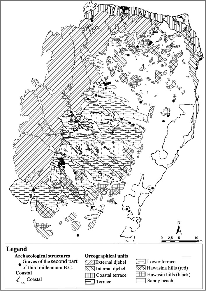
Map of the sites during the second half of the third millennium BC Black circles: Graves of the second part of third millennium BC/Other legends are: Coast, External djebel, Internal djebel, Coastal terrace, Terrace, Lower terrace, Red Hawasina hills, Black Hawasina hills and Sandy Beach).
Fig. 6. Carte des sites de la deuxième moitié du troisième millénaire avant J.-C. (Cercles noirs : tombes de la deuxième moitié du troisième millénaire avant J.-C./Les autres légendes sont : Côte, Djebel extérieur, Djebel intérieur, Terrasse côtière, Terrasse, Basse terrasse, Collines d’Hawasina rouge, Collins d’Hawasina noire et Plage sableuse).
These new type of burials, with increasingly complex rituals, abandoned the highest sectors of the landscape to be located closer to the settlements, probably filling new functions in social ideology. Earlier monuments appear preserved and continue their role as territorial markers [6].
The settlement is focused on a system that includes the dwelling, the necropolis and the oasis.
7 Conclusion: evolution of settlement patterns in accordance with social and economic change
The study of the links between settlements could only be made for the final two periods, as we do not have enough data for the Neolithic period. We used a gravity analysis. This permits us to evaluate the pull of the sites depending upon their mass and their position in space [6,12]. The reciprocal pull can also be determined. The mass has been calculated from the size of the necropolis linked to the settlement, i.e. the number of graves [6,7].
The unity of funeral, living space and oasis place is organised in a dense network of complex sites within which a regional hierarchy is clearly expressed [6,7]. So a sustained relationship existed between the coast, the lagoons and the piedmonts. These relations are more significant for the second half of the Early Bronze Age.
Indeed, during the first period, the sites around the lagoons guide the flow, whereas later it is the opposite: piedmont sites become important and lagoonal sites tend to disappear as the lagoons dry up.
If we reconsider the environments defined by local Bedouins, the change of places in the dynamic of settlement combines with changes in the use of environment and economic activities. During the first period of the Early Bronze Age, the occupied areas do not completely differ from those of Neolithic. Preferred ecosystems are el-Bahr and el-Khawr: aquatic environments. This means that the economy would have been partly oriented in fishing and shells gathering in marine/ lagoon area, but at the same time they occupy el-Jabal and el-Wadi showing a possible agricultural and pastoral occupation in association with this fishing economy. It should not be forgotten that for part of the year the area el-Bahr is impossible or very difficult to inhabit, and that inland traces could mean a winter occupation of those places. These inland sites may have been annual occupations. In the second period, the rocky areas become prevalent: el-Jabal and el-Wadi seem more attractive than coastal and lagoon sites, which are abandoned, with the important exception of RJ-2. This change in the spatial dynamics of the sites may have followed economic developments visible in the Oman Peninsula where oases are in full development. The development of the agricultural system, in parallel with the drainage of the lagoons, would be an explanation for the change of spatial settlement patterns.
The 8000 years of human history in the Ja’alan show a certain density of settlement. At first this occupation was linked to the resources from the sea. Then, with human actions on their environment, the settlements were linked to the small oases, which brought a diversification of resources as well as a tighter appropriation of space. This finally resulted in a rather dense occupation based on a more sedentary life in this arid environment.