

1 Introduction
The soft cover stratigraphy study of different shelves was a research objective during the last decade, in particular within the international program framework STRATAFORM (Nittrouer, 1999). The soft sedimentary cover of the Aquitaine shelf was only studied recently thanks to the improvement of new seismic data acquisition and processing (Cirac et al., 1997). Several seismic profiles have been acquired between 1998 and 2001 from the canyon of Cap Breton to the Gironde estuary. We used Vail's (Vail, 1976) and Galloway's and (Galloway, 1989) sequential stratigraphic models for the interpretation of the seismic units and sequences. According to these models, the cyclic fluctuations of the “accommodation space”, essentially related to the eustatism, generate sequences on different time scales (from first to fifth order). These sequences are bounded at the base and top by unconformities that mark major sea level falls. The study area (Fig. 1) corresponds to the seaward Aquitaine Basin prolongation (Boillot et al., 1984). The Aquitaine shelf displays a westward progradationnal strata pattern (Crémer, 1983). It belongs to the siliclastic sedimentary cover of the continental shelf where the actual hydrodynamic is dominated by storms and swells (Cirac et al., 2000). The interest for this area is explained because it is potentially a good paleo-environmental sedimentary record, as the sedimentary supplies from two great drainage basins (Garonne and Adour basins) was important until the last Pliocene. This high sedimentary supply led to a thick sedimentary body deposited between the Pliocene and the Quaternary (sedimentation rates ranging from 70 to 140 m/My) and the Upper Quaternary with a great increase of the sedimentation rates around the canyon of Cap Ferret (several tens cm/1000 years) (Crémer, 1983).
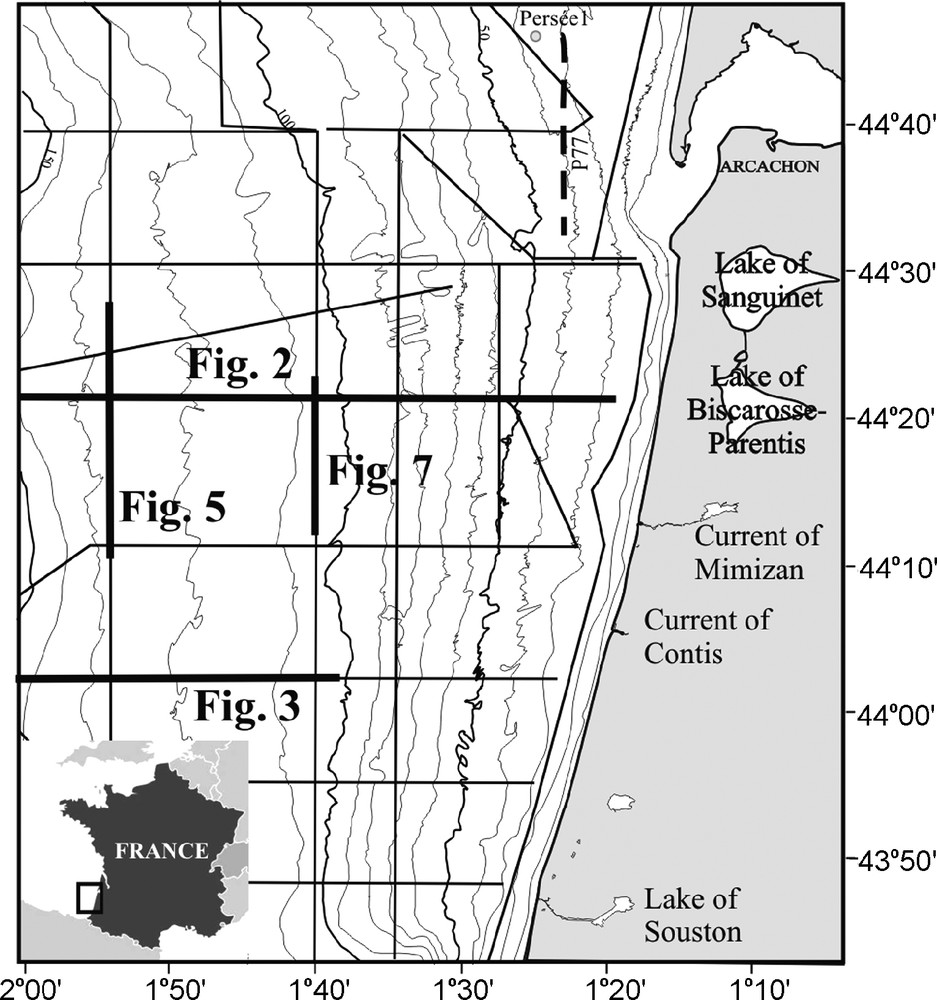
Location of the study area and the seismic profiles of the ITSAS1 sea survey. The seismic profiles shown in the paper are indicated in bold. The dotted line shows the seismic profile P77 and the Persée 1 is represented by a spot (Feniès and Lericoalais, 2005).
Localisation de la zone d’étude et des profils sismiques de la mission ITSAS1. Les profils montrés dans cet article sont indiqués en gras, le profil P77 par la ligne en pointillés et le forage Persée 1 par un point (Feniès et Lericoalais, 2005).
The aim of this work is to describe the stratigraphical organization of the South-Aquitaine soft cover shelf, of the last seismic sequences and their relationship with glacio-eustatic cycles. These seismic sequences could correspond to fourth or fifth order high frequency cycles (100 ky and 20 ky according to Mitchum and Van Wagoner, 1991).
2 Data
The seismic data were shot thanks to a “Sparker” source with a power of 650 j supply during the ITSAS 1 and 2 cruises (August 1998, June 2001) on the R/V “Le Suroît”. The centre frequency was 800 Hz allowing a vertical resolution of about 1 m. The shooting rate was one second and the vertical penetration was of about 400 two-way travel time milliseconds (twt ms). Dara were recorded thank to a single channel streamer. Real time processing was carried out thanks to the DELPH 2 software. Complete processing was achieved thanks to SITHERE software (IFREMER® in Lericolais et al., 1990).
3 Seismic results
The sedimentary cover U1 is composed of six major units limited by erosional surfaces. Each of them can be subdivided in two sub-units. These units and sub-units display a repetitive pattern.
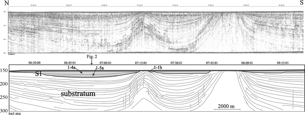
The erosional unconformity (S1) at the bottom of the sedimentary cover (U1) is observed on all the seismic profiles (Fig. 1). It is particularly clear on the inner and medium shelves. S1 strongly eroded the underlying sediment during its formation (Figs. 2 and 3). It is characterized by good continuity and high amplitude reflection. This unconformity is covered by deposits considered as soft or slightly dense (Cirac et al., 1997). Our seismic profiles on the continental shelf shows three zones of deposition (Fig. 2): the outer zone, between the shelf slope and 100–110 m water depth, the median zone between 100–110 m and 50–60 m water depth and the inner zone from these 50–60 m water depth to the coast.

East-west sparker profile located in the centre of the South-Aquitaine shelf (see Fig. 1 for the location). The soft cover deposits on the substratum on the erosive surface S1. Three zones are present: the outer zone characterized by a stacking of deposit units, the median zone where the U1 thickness is thin, and the inner zone.
Profil sparker est-ouest situé au centre de la plate-forme Sud-Aquitaine (voir Fig. 1 pour la position). La couverture meuble se dépose au-dessus du substratum sur la surface érosive (S1). Trois zones sont présentes : la zone externe caractérisée par un empilement des unités de dépôts, la zone médiane où U1 s’amincit, et la zone interne.
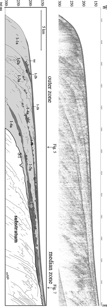
East-west sparker profile (location see Fig. 1) showing the erosion of the substratum S1. Six units, U1-6 to U1-1, composed by the sub-units “a” and “b” deposit on S1.
Profil sparker est-ouest (voir la Fig. 1 pour la position) montrant l’érosion du substratum durant la formation de S1. Six unités, U1-6 à U1-1, composées par les sous-unités “a” et “b” se déposent sur S1.
3.1 The outer zone
The sedimentary cover U1 is constituted by the stacking of six seismic units (U1–1 to U1–6) subdivided in 11 sub-units. From base to top, each seismic unit typically includes (Fig. 4):
- • a lower boundary (S) represented by an erosional unconformity marked by a medium amplitude reflection. It shows several well-marked channels and covers a strongly eroded deposit;
- • a lower sub-unit “a”, generally thick, consists of chaotic acoustic facies characterised by channel-shaped reflections and reflections having poor lateral continuity;
- • an internal unconformity (St), constituted by a high amplitude and good continuity plane reflection;
- • an upper sub-unit “b”. It is thinner than the sub-unit “a” probably because it has been strongly eroded by the formation of the surface (S). Its internal configuration is subparallel with downlaps or onlaps at the bottom and erosional truncatures at the top.
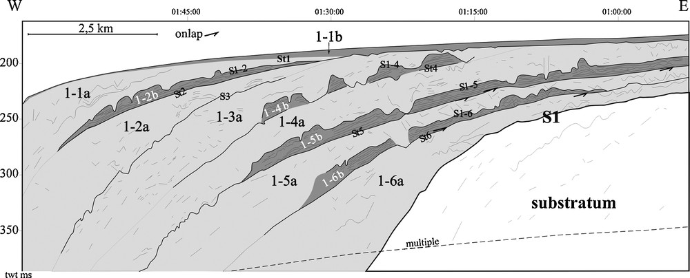
Detail of the Fig. 2, located on the outer shelf, showing the alternation of the two sub-units “a” and “b”.
Détail de la zone externe de la Fig. 2 montrant l’alternance des deux sous-unités “a” et “b”.
The six seismic units show strong similarities (Figs. 3, 4 and 5). All of them are composed by two sub-units except U1-3, which displays only one sub-unit (U1–3a). The unconformity between U1-2 and U1-1 (S1-2) is strongly erosive and levels the continental shelf. Oppositely to other sub-units U1-1b is characterized by a transparent to parallel facies upward. It goes on onshore with a draped facies from 1 m to a few meters thick.

North-south sparker profile showing three units (U1-6, U1-5 and U1-1). The surfaces (S) are strongly erosive and can show channels (S1, S1-6). The sub-units pinch out northward.
Profil sparker nord-sud montrant trois unités (U1-6, U1-5 et U1-1). Les surfaces (S) sont fortement érosives and peuvent montrer des chenaux (S1, S1-6). Les sous-unités se biseautent vers le nord.
3.2 The medium zone
This area is characterized by a small thickness (3 to 20 twt ms, around 2.5 to 18 m) of the soft cover (Fig. 6). Most of the sub-units of U1 pinch out between −150 and −110 m water depth (U1-1a, U1-2, U1-3, U1-4b, U1-5b, U1-6b; Fig. 2). Some of them persist in the medium zone but only the sub-units U1-4a and U1-1b are present in the inner shelf. In fact, all the sub-units “b” except U1-1b disappear before the median zone. Then U1-1b corresponds to a deposit of a few meters thick. In this area, uplifted sediments by diapirs are eroded (Fig. 7).
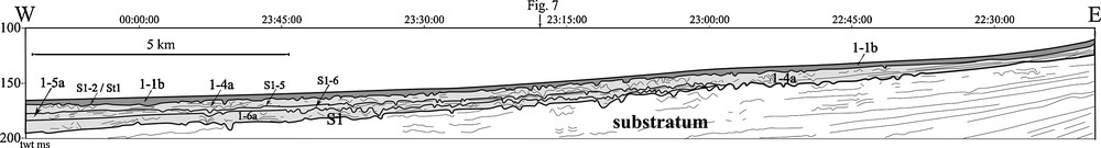
Detail of of the Fig. 2, located on the median shelf, showing four units (U1-6, U1-5, U1-4 and U1-1). Except for the unit U1-1, all the other ones are composed by the sub-unit “a”. Only U1-4a reaches the inner zone.
Détail de la zone médiane de la Fig. 2 montrant quatre unités (U1-6, U1-5, U1-4 et U1-1). Toutes les unités de dépôts sont seulement composées par la sous-unité “a” sauf pour U1-1. Seule U1-4a continue jusqu’à la zone interne.
Diapirs deforming strongly the substratum and the soft cover U1.
Diapirs déformant fortement le substratum et la couverture meuble U1.
3.3 The inner zone
Only two units can be locally observed in the inner shelf (U1-1 and U1-4, Fig. 8). U1-4a disappears eastwards under U1-1. The sub-unit U1-1b thickens onshore and constitutes a great part of the unit U1-1. Its thickness can reach more than 20 ms twt. This sub-unit is composed of high amplitude oblique reflections, which show downlaps and toplaps or erosive truncatures at the top. Its acoustic facies becomes more transparent and chaotic eastwards with reflections having poor lateral continuity. Internal reflections of U1-1b are less frequent and their amplitude are higher compared to those observed in the ones which compose the sub-unit “b” offshore. Channels located at the base of the unit U1-1 are filled by U1-1b characterized by a transparent facies.
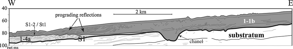
Detail of Fig. 2, located on the inner shelf, showing two units U1-4 and U1-1.
Détail de la zone interne de la Fig. 2 montrant deux unités U1-4 et U1-1.
The upper part of the sub-unit U1-1b shows a high continuity reflection from the outer to the inner shelves. This reflection is often merged with the sea bottom reflections and locally displays very small channels (a few meters deep).
4 Discussion
4.1 Age
The lack of long cores and datations leads to more or less hypothetical stratigraphical interpretation. In fact, only few wells have been drilled. Their results only allow evidencing the transition between Plio-Quaternary and Miocene deposits in the upper part of the cores corresponding to the seismic profiles shown in this study. U1 belongs to the Plio-Quaternary deposits. Despite the lack of detailed core results, the sequential stratigraphic pattern of the South-Aquitaine shelf can be interpreted by using the concepts of sequence stratigraphy (Vail, 1976; Vail and Mitchum, 1977; Vail et al., 1977; Posamentier et al., 1988a, 1988b; Vail et al., 1991) because it shows similarities with other modern shelves. In the Gulf of Cadix (Somoza et al., 1997; Hernandez-Molina et al., 2002 or in the Gulf of Lion (Tesson et al., 1990; Tesson et al., 1993; Rabineau et al., 2005; Jouet, 2007), an Upper Quaternary age is indicated for the soft cover base. Previous works on the Aquitaine shelf (Lericolais et al., 2001; Feniès and Lericolais, 2005) seem also to indicate a post-Pliocene age for the surface S1 and a Quaternary deposit of about 30 m (33 ms twt) at −40 m depth (Persée 1 drilling, Fig. 1) (Feniès and Lericolais, 2005). Seaward of the Arcachon Lagoon, the last phase of incision within the Pliocene basement of the Leyre valley occurred between 120,000 and 18,000 years BP. It was filled during the last sea level rise after 18,000 years BP (Feniès and Lericolais, 2005), like the Gironde valley (Lericolais et al., 2001). This would indicate that S1, likely corresponding to the RS1/R1 reflections of these authors, is younger than 120,000 years BP. U1-1b may correspond to US1/S2-S3 (Lericolais et al., 2001; Feniès and Lericolais, 2005), that is the last transgressive deposit system, and then be younger than 18,000 years BP on the inner shelf. This age is also coherent with (Arbouille, 1987) obtained in the North-Aquitaine shelf. The increasing accommodation space during the sea level rise could allow a better preservation of the deposit. The low thickness of this sub-unit on the median zone could be linked with the constant moving eastward of the coast and the wave erosion.
4.2 The sequence-type: process of formation in the outer zone
The subsidence on the South-Aquitaine shelf plays a role in the sediment preservation (Brunet, 1983; Brunet, 1994; Brunet, 1997; Brunet et Beslier, 1990), favouring thicker sediment deposits comparing to the North-Aquitaine shelf. In contrary, local uplift in the median zone due to diapirism can favor erosion. Sediment supply also plays a role in sediment preservation. It is variable along the Aquitaine shelf (Legigan, 1979) and generally evolves with the sea level changes (Caralp, 1971; Legigan, 1979; Laville et al., 1983). In the area of the outer shelf, the formation of the sequence-type is considered as essentially controlled by sea level changes.
Seismic units evidenced by this study show a sequential pattern and the formation of each sequence is interpreted as follow (Fig. 9):
- • the lower boundary of the sequence corresponds to a phase of erosion (phase 1, surface [S]). Such erosion can happen in a period of sea level fall. The sediment brought from the continent or eroded on the shelf is evacuated toward the slope base and the glacis, with the formation of the very irregular erosional unconformities on the outer shelf;
- • the second phase (sub-unit “a”) may record the period of sea level lowstand and early sea level rise. Due to the low sea level, the wave and tide erosions increase leading to an increase of the energy level on the sea bottom which is coherent with the chaotic acoustic facies and channel structures which filled the troughs due to the formation of the surface S. The sub-unit “a” is interpreted as a lowstand systems tract. The little channels (a few hundred of meters wide, a few meters deep) could correspond to fluvial channel filled by gravel and sand (chaotic acoustic facies of sub-unit “a”);
- • the third phase begins with the high amplitude planar surface truncation (St) on the chaotic acoustic facies. It could correspond to a transgressive or a ravinement surface during a sea level rise. It is interpreted as the transition between the deposition of the lowstand system tract and the deposition of relatively finer and more homogeneous deposits characterized by subparallel reflections (sub-unit “b” of the sequence). Giving (St) is a planar and regional erosional surface, it is interpreted as a wave ravinment surface. As this surface is observed in the inner zone (especially St1), we consider the surface (St) as a transgressive surface linked to a wave erosion;
- • the fourth phase corresponds to the deposition of the sub-unit “b” which progrades westwards. This internal configuration which ends up in “downlaps” offshore on the southern part of the Parentis Basin, could record an increase in sediment supply or a decrease in accommodation space (uplift linked with a regional diapirism?) while the onlaps on the northern part of the Basin of Parentis could testify to a single increasing of the accommodation space, probably during a transgression. The sub-unit “b” is deposited on the transgressive surface (St), and interpreted as belonging to the transgressive systems tract;
- • the next phase corresponds to a new erosive phase related to a sea level fall (phase 1, S) similar to the first phase. It is marked by incisions and sub-parallel facies erosion and it constitutes the upper limit of the sequence.

Four phase Processes of sequence-type formation on the outer South-Aquitaine shelf.
Processus de formation de la séquence type de la plate-forme externe Sud-Aquitaine en quatre étapes.
4.3 Sequence 1-1: a whole stratigraphic cycle
The sequence U1-1, located in the upper part of the soft cover, shows a complete sedimentary sequence. On the outer shelf, U1-1 is composed by U1-1a (interpreted as the lowstand systems tract) and U1-1b (interpreted as the transgressive systems tract). U1-1a pinches out at about 180 ms twt (135 m) where the erosional unconformity S1-2 merges with the transgressive surface St1. This compound surface corresponds to a regional erosion surface followed all along the continental shelf, between the present-day coast to around 135 m water depth where S1-2 deepens. This surface is covered from 135 m water depth to the coast (inner and median zones) by the transgressive systems tract U1-1b. At about 60 m water depth, this compound surface merges with the sequence boundary S1.
In the inner zone, the base of U1-1b (S1) shows channels similar to the Leyre valley, which are interpreted as formed by the fluvial erosion during the last sea level fall by (Feniès and Lericolais, 2005). The transgressive systems tract U1-1b begins with the filling of the channels, like in the Leyre valley (Feniès and Lericolais, 2005). Upwards U1-1b shows a quite thick chaotic acoustic facies (about 20 m thick) with small channels and a few sub-parallel and oblique reflections. This pattern could indicate another fluvial erosion and filling. As the profile of the Fig. 2 is located seaward of the Lake of Biscarosse-Parentis, this acoustic facies may correspond to a buried inlet related to the connection between this lake and the ocean. This explains that U1-1b thickens towards the coast and forms a sedimentary prism. Moreover, this sub-unit has oblique reflections westwards which show a progradation (Fig. 8). This could correspond to a tidal delta located at the mouth of the Lake of Biscarosse-Parentis. The prograding reflections inside this prism are often of stronger amplitude and could correspond to old sandy-gravely beaches (Fitzgerald et al., 1992), which may record a transgression.
The last wave ravinement surface could be the surface merged with the sea bottom reflections.
5 Conclusion
The sequential pattern evidenced by the high resolution seismic stratigraphy of the South-Aquitaine shelf can be interpreted as a record of recent sea level variations. Six sequences are identified within the soft sedimentary cover. They could have been deposited during the Late Quaternary (after 120,000 years BP), the last sequence was probably formed during the last fifth order eustatic cycle sea level changes. Each of these sequences begins with an erosional unconformity (S) formed during the sea level fall and is composed by two sub-units “a” and “b” separated by a transgressive surface (St). The lower sub-unit “a” corresponds to the lowstand systems tract. It shows a chaotic facies with little channels which may correspond to anastomosed channels filled with gravel and coarse sand. The top of this sub-unit is levelled by the transgressive surface (St) formed thanks to the wave ravinment. The sub-unit “b” is characterized by a sub-parallel facies, composed of aggrading to prograding reflections northward to southward which may indicate more homogeneous and relatively well-sorted deposits. Sub-unit “b” corresponds to the transgressive systems tract. In the inner zone, sub-unit “b” is essentially characterized by the last transgressive systems tract deposited after 18,000 years BP. The sub-unit “b” is truncated by the next sequence deposit. This sequence-type is repeated on the outer shelf with minor changes which are essentially linked with different sub-unit thickness. Only the sub-unit “a” is observed onshore, the sub-unit “b” pinching out quickly except the youngest sub-unit U1-1b. In fact, the major part of the sub-units “b” is eroded shoreward. The sedimentary prism on the inner shelf is composed by the last transgressive systems tract U1-1b and corresponds to the deposition of old sandy-gravelly beaches marking old shorelines formed during the last transgression.