

1 Introduction
The tectonically induced shortening of sedimentary basins triggers large decollement surfaces on which the operative deformation takes place. This detachment propagates within a ductile layer toward the external part of the orogen, even if the decollement could rise up locally into the stratigraphic sequence, thus propagating partly or entirely in upper resting ductile layers. Fault components, which may connect two decollements or a decollement horizon and the land surface plane, are named “ramps” (Dhalstrom, 1970; Elliott, 1976a, 1976b; Rich, 1939). The allochthonous displacement onto the decollement surface generates fold in the sedimentary cover, situated precisely above the ramps (ramp folds or fault-related folds). In case of ramps striking orthogonal to the direction of tectonic shortening, the developed folds trend orthogonally to the tectonic displacement. Indeed, this is the case of the classically described frontal ramp folds (Jamisson, 1987; Suppe, 1981, 1983; Suppe and Medwedeff, 1990). However, the ramps may also trend obliquely or even laterally, thus inducing a less common tectonic displacement and related folding, with fold axes striking obliquely or even parallel to the direction of tectonic rejection.
Lateral ramp edifice description is less common in literature than the frontal ramps (Cook and Thomas, 2009; Sanghoon and Mitra, 2006; Wilkerson and Medwedeff, 1991). This is due to the tendency of structural geologists to work on cross sections and also to the fact that probably many of the lateral ramp folds have been interpreted as frontal ramp folds generated during another tectonic event, or simply as drag folds along major transverse transcurrent faults.
To the previous question debating whether lateral ramp folds are formed above lateral ramp faults or due to more classical causes, we need to solve the problem related to the location of rock thinning through the ramp fold (Frizon de Lamotte et al., 1994, 1995) and the mechanism instigating the lateral ramp fault formation.
In northern Tunisia domain (Tellian and Numidian series), numerous folds trending almost orthogonally to the chain elongation, of which two are considered hereafter, constitute a great opportunity to demonstrate by mean of suitable criteria, that at least some of these structures are formed above lateral ramps and that they are not folds triggered by the other previously mentioned mechanisms. Basing upon the detailed lithostratigraphical and paleogeographical settings of the studied area, we provide a genetic mechanism for these lateral ramps, which regards them as nucleated above syndepositional direct faults, thus corroborating recent works on frontal ramps (Ballard et al., 1987; Creusot et al., 1992; Morley, 1988; Ould Bagga, 2003; Ould Bagga et al., 2006).
2 Regional setting
The northern Tunisia thrust-and-fold belt (Fig. 1) comprises stacking tectonic units (or nappes), involving the lowermost Tellian units and the overlying Numidian unit, the depositional sites of which were originally distant (Khomsi et al., 2009; Rouvier, 1977). More recently, it was shown that the Numidian nappe was defined as an “out of sequence thrust” with respect to the underlying imbricate Tellian units (Rouvier, 1977; Morley, 1988; Ould Bagga et al., 2006). This implicates a large tectonic transport of Numidian nappe. Conversely (Ould Bagga, 2003; Ould Bagga et al., 2006), the Tellian unit's displacement was shorter, even below 5 km. According to these author understanding, it is likely that the marked stratigraphic and sedimentologic disparities between the imbricated Tellian units are due to synspositional tectonics, which has been operative in Triassic-Early Miocene time interval. During this period, tectonic tilted-blocks, which formed the sites for sedimentation, were separated by normal NE-SW striking and transverse faults, in a checkerboard-like tectonic configuration.

Geological map of the NW Tunisia and detailed map location. A. Structural map of Tunisia, (Zargouni, 1985); a: Numidian nappe zone; b: Graben zone; c: Imbricate zone; d: Atlas front. B. Geological map of NW Tunisia (extracted and modified from the geological map of Tunisia, 1/500 000, ONM: National Office of Mining, 1985) and location of lateral ramp folds; a: Magmatic rocks; b: Triassic; c: Jurassic; d: Cretaceous; e: Palaeogene; f: Numidian (Oligo-Miocene flysch); g: Mio-Pliocene; h: Quaternary.
Carte géologique du Nord-Ouest de la Tunisie et localisation des cartes de détail. A. Carte structurale de la Tunisie, (Zargouni, 1985) ; a : zone de la nappe numidienne ; b : Fossés d’effondrement ; c : Zone des Écailles, d : Front Atlasique. B. Carte géologique du Nord-Ouest de la Tunisie (1/500 000, ONM : Office National des Mines), modifiée, et localisation des plis latéraux ; a : Roches magmatiques ; b : Trias ; c : Jurassique ; d : Crétacé ; e : Paléogène ; f : Séries numidiennes (flysch Oligo-Miocène) ; g : Mio-Pliocène ; h : Quaternaire.
The prominent Middle Miocene compression and subsequent inversion have led to frontal ramp nucleation on the NE-SW normal faults, that have systemically shifted the basal decollement level, which is favored by Triassic evaporites. This tectonic inversion and other similar were mainly approached from field cross sections running perpendicular to thrust elongation. This resulted in the general occluding of the transverse fold structural significance in the thrust-and fold belt edification. However, examples of NW-NS trending folds are abundant in the Tunisian thrust-and-fold belt, most of them set along northwest and northsouth striking faults (Fig. 1B).
The present work is based on field investigations carried out with the aim to characterize deformation originating in NW-SE and north-south transverse fold axis. These structures were considered, in the Northern Tunisian belt as well as in the Tunisian Atlas, as frontal fold lateral terminations, drug folds along NW-SE or north-south trending transcurrent faults or fold triggered by north-east to west-east directed compression event.
In the subsequent sections, we will point out that at least some of these folds have been induced by lateral fault related decollement risings, inherited from the Meso-Cenozoic checkerboard-like tectonic setting. For this aim, we will discuss two lateral ramp fold examples of different scales: one in the outermost Tellian unit and another in the Numidian flysch at this tectonic unit front.
3 Lithostratigraphic sections and tectonosedimentary setting
3.1 The Hairech unit
This unit lies at the bottom of the structural edifice, and exhibits vertical clay strata, sandstones and limestone turbidite beds, which are considered to be of Hauterivian-Barremian in age (Fig. 2), based on facies similarities with dated sedimentary series occurring at the J. Bessouagui (Ould Bagga et al., 2006). These Lower Cretaceous deposits are overlain by their own stratigraphic cover, by means of a thrust surface, delineated by Triassic evaporites. The cover includes Santonian-Maastrichtian limestones and marls to the bottom and thin Palaeogene and Lower Miocene shallow marine deposits to the top (Fig. 2).

Synthetic lithostratigraphic section of el Hairech unit (at Aïn el Bey area).
Colonne lithostratigraphique synthétique de l’unité Hairech (secteur d’Ain El Bey).
3.2 The Kasseb unit
This unit which over-thrusts the preceding Hairech unit, starts locally in Paleocene grey marls, but comprises essentially thick Globigerine-rich Ypresian limestones (Fig. 3). Locally in the Kef Rochga quarry to the west of Aïn El Bey, the Ypresian includes N-S striking lens-shaped limestones containing Nummulites, siliceous Sponges and other neritic fauna (Fig. 3 and Photo 1 in Fig. 7). These facies form sequences with graded breccias at the bottom, grading upwards into finer and Nummulitic-rich deposits. These may testify to a local tectonic instability, which caused the reworking of neritic sediments originally deposited on north-south paleohighs, towards the neighboring deep-seated basin.
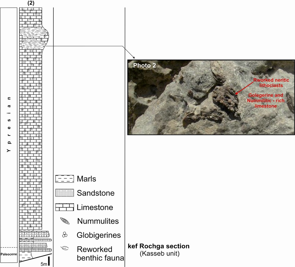
Synthetic lithostratigraphic section of Kasseb unit (at Kef Rochga). Photo 2: neritic lithoclasts scattered in the lens-shaped Nummulitic-rich limestones, belonging to the Ypresian Globigerine-rich rock-package. These facies are encountered in the steep fold forelimb, located in the west of the Photo 1 (Fig. 7).
Colonne lithostratigraphique synthétique de l’unité Kasseb (secteur de Kef Rochga). Photo 2 : faciès à faune néritique dispersée dans une lentille de calcaires à Nummulites, située dans la barre de l’Yprésien à Globigérines. Ces faciès sont localisés dans le flanc aval redressé du pli, situé dans la partie ouest de la Photo 1 (Fig. 7).
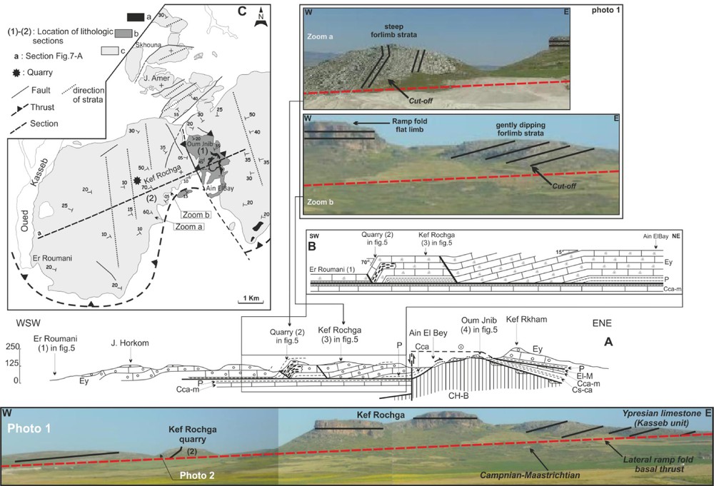
A. General WSW-ENE cross section of Ain El Bay area. B. Geological details of the Kef Rochga quarry. C. Geological map of the Ain El Bey area and section locations; a: Triassic; b: Hairech unit; c: Kasseb unit; CH-B: Hauterivian-Barremian; Cs-ca: Santonian-Campanian; Cca-m: Campanian-Maastrichtian; P: Palaeocene; Ey: Ypresian; El-M: Lutetian Miocene; Og-M: Oligocene-Miocene. Photo 1: N15 striking lateral ramp fold affecting the Ypresian limestone to the west of Aïn El Bey. Note the kink-fold geometry and the basal cutoffs of the Ypresian limestone beds, at their contact with the underlying Campanian-Maastrichtian deposits (Fig. 7A for comparison).
A. Coupe générale WSW-ENE du secteur d’Ain El Bey. B. Détail du secteur de la carrière de Kef Rochga. C. Carte géologique du domaine d’Ain El Bey et position des sections lithologiques ; a : Trias ; b : Unité Hairech ; c : Unité kasseb. CH-B : Hauterivien-Barrémien ; Cs-ca : Santonien-Campanien ; Cca-m : Campanien-Maastrichtien ; P : Paléocène ; Ey : Yprésien ; El-M : Lutétien-Miocène ; Og-M : Oligocène-Miocène. Photo 1 : Pli de rampe latérale orienté N15 affectant les calcaires de l’Yprésien à l’ouest d’Aïn El Bey. Noter la géométrie en kink et les troncatures (Cut-off), affectant les bancs calcaires de l’Yprésien, à son contact avec le Campanien-Maastrichtien sous-jacent. Zooms a et b in Fig. 7 de la Photo 1 et leurs emplacements sur la coupe géologique WSW-ENE de la Fig. 7-A.
Based upon the widespread normal faulting hosted in the Northern Tunisia Ypresian rocks (Ould Bagga et al., 2006), among which those outcropping in the study area, we consider that the NW-SE lithostratigraphic correlation between the Ain el Bey and the Kef Rochga sections (Fig. 4), evidences a NE-SW trending ridge and basin set delimitated by normal faults, that originated into south-west-ward tilted blocks, whose crests are marked by section thinning and stratigraphic gaps (Fig. 5).

Lithostratigraphical correlation of el Hairech and Kasseb sections.
Corrélation lithostratigraphique des séries des unités de l’Hairech et du Kasseb.
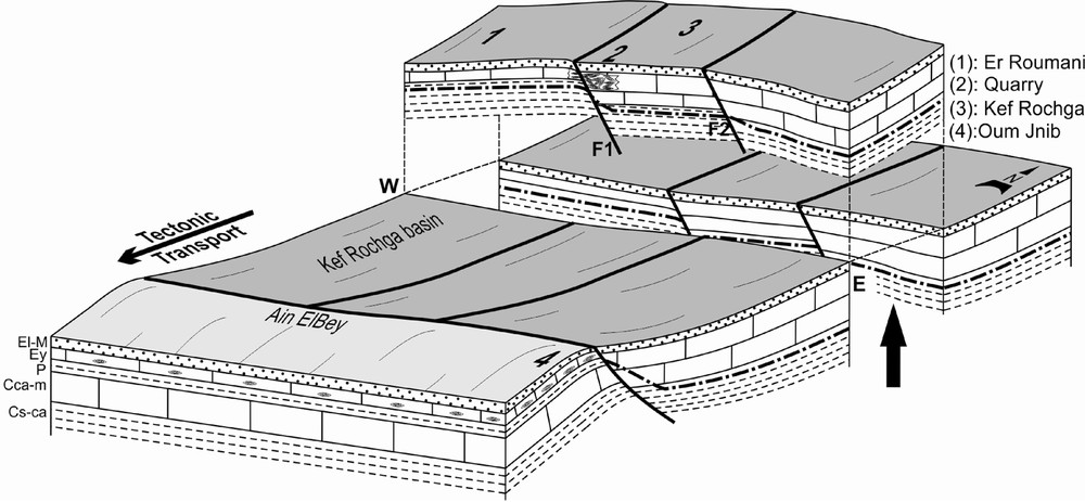
Preinversion synthetic block diagram showing the Aïn El Bey ridge (Hairech unit) and the Kef Rochga basin (Kasseb unit). A portion is raised in the drawing to allow observation of the cross-section (Fig. 7B). CH-B: Hauterivian-Barremian; Cs-ca: Santonian-Campanian; Cca-m: Campanian-Maastrichtian; P: Palaeocene; Ey: Ypresian; El-M: Lutetian Miocene; Og-M: Oligocene-Miocene.
Bloc diagramme synthétique anté-inversion montrant la ride d’Ain El Bey (unité Hairech) et le bassin de Kef Rochga (unité Kasseb). Une partie est soulevée dans le dessin pour permettre l’observation de la coupe (Fig. 7B) dans un état anté-inversion. CH-B : Hauterivien-Barrémien ; Cs-ca : Santonien-Campanien ; ca-m : Campanien-Maastrichtien ; P : Paléocène ; Ey : Yprésien ; El-M : Lutétien-Miocène ; Og-M : Oligocène-Miocène.
Although the NE-SW facies variations are less obvious than the NW-SE ones, especially for the Kasseb unit due to its basal tectonic ablation and the erosion induced decapitation, we can consider that the neritic fauna-rich limestone lens, could outline a genetically linked north-south trending tilted block crest and a parallel direct fault, which were latter transported during tectonic inversion (Fig. 5).
3.3 The Numidian unit
The Numidian unit is made up of a deep-sea clay-sandstone-turbidtic bearing sequence of an Oligo-Miocene age (El Maherssi, 1992; Riahi et al., 2009; Rouvier, 1977; Yaïch, 1997). The Numidian flysch was subdivided into three stratigraphic units (Rouvier, 1977); the lower unit corresponds to the thick (at least 1500 m) and clay-rich “Zouza” member, which is of Rupelian-Chattian in age (El Maherssi, 1992; Yaïch, 1997); to the middle, the “Kroumiries” sandstone unit (Oligocene-Aquitanian) and the top, “Babouch” sandstones unit (Burdigalian).
Biostratigraphic revisions were also brought to such synthetic section (El Maherssi, 1992; Yaïch, 1997), of which at least one has identified an Aquitanian deposit at the top of the “Zouza” unit clays (Boukhalfa et al., 2009; Riahi et al., 2009).
The section presented in Fig. 6 shows the previous stratigraphic units together with their SW-NE lithostratigraphic correlation. This figure demonstrates clearly that the Rupelian-Chattian thinning toward the south-west is accompanied by facies change, expressed by more abundant clay layers in the eastern part of the Numidian nappe (“Zouza” member), than in its western part. This facies variation seems to be neither simply related to a basal tectonic shopping of the “Zouza” member, nor to the rising of the decollement level in younger and sandstones-richer rocks (“Kroumiries” or “Babouch” members). Indeed, to the west of J. Bou Goutrane where the sandstone bars are abundant in the bottom of the Numidian flysch, a marl sample located just above the Numidian basal thrust provided biostratigraphic data attesting a Rupelian age. Accordingly, this sandstone dominated rock-system differs from the “Kroumiries” or “Babouch” units and thus, it corresponds to a lateral equivalent of the “Zouza” member. Such lateral facies variations have been described previously to the east, in the Numidian front of the Mogods (El Maherssi, 1992; Yaïch, 1997).
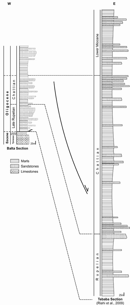
Lithostratigraphical correlation of the Numidian series at J. Tebaba (Riahi et al., 2009) and Balta areas.
Corrélation lithostratigraphique des séries numidiennes de J. Tebaba (Riahi et al., 2009) et de Balta.
This facies and thickness variation is attributed to the extensional tectonic setting proposed for the Numidian flysch depositional basin by Yaïch (1997) and Dlala (1995a, 1995b), which is also demonstrated for the Oligo-Miocene sandstones in the Tunisian Atlas (Chihi, 1995). We have recently observed a normal fault system in the Upper Eocene to Lower Oligocene deposit, belonging to an inner Tellian unit. These observations lead us to suggest a tectonosedimentary structure which supposes the presence in the Numidian basin, of a major transverse synsedimentary fault, currently transported within the nappe (Figs. 6 and 8).
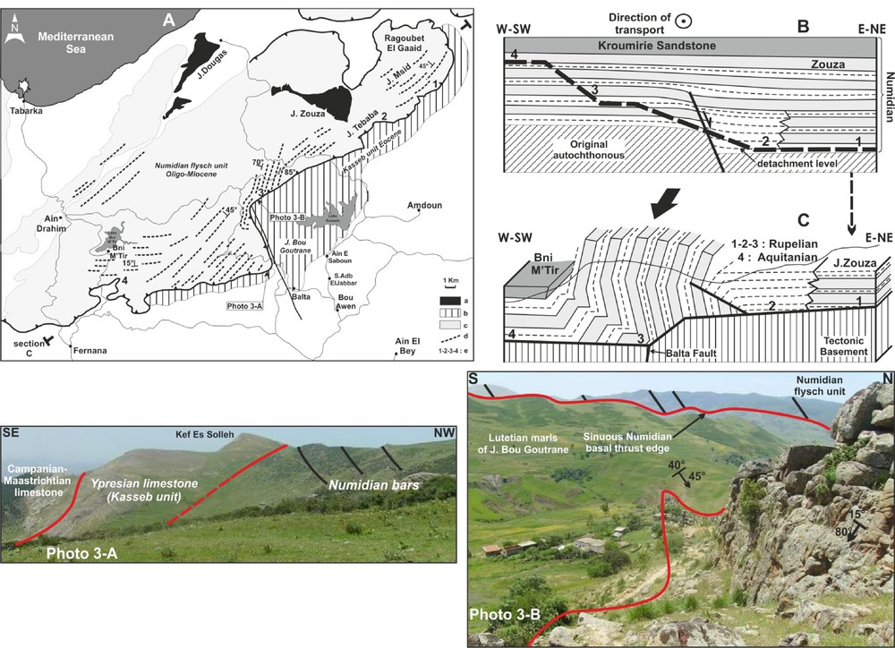
A. Simplified geological map of J. Zouza-Balta-Bni MTir area; a: Triassic; b: Cretaceous-Eocene sediment (corresponding to autochthonous substrata of Numidian); c: Numidian; d: Numidian sandstone bars near its basal contact; e: Sites providing biostratigraphic data. B. Reconstitution of the Numidian depositional basin and the future detachment location (1-2-3-4: Sites providing biostratigraphic data). C. Geometry of an E-W Numidian section of J. Zouza-Balta area. Photo 3: -A. NE-SW directed section of the Numidian nappe, showing steep dipping to inverted N15 trending Numidian beds and their truncation by the flysch basal thrust. The north-south oriented segment of the Numidian basal thrust edge, coincides sensibly with the Balta fault plane. B. N40 striking and less steep Numidian beds, truncated by the basal thrust. The substratum constituted by the Kasseb unit, belongs to the Balta fault footwall block.
A. Carte géologique simplifiée du secteur de J. Zouza-Balta-Bni M’Tir ; a : Trias ; b : Crétacé/Eocène (autochtone relatif du Numidien) ; c : Numidien ; d : Bancs gréseux du Numidien à proximité de son contact basal ; e : localisation des datations biostratigraphiques. B. Reconstitution du bassin numidien avec la position du futur décollement (1-2-3-4 : localisation des datations biostratigraphiques). C. Géométrie d’une section est-ouest du Numidien du secteur de J. Zouza-Balta-Bni M’Tir. Photo 3 : -A. Section NE-SW montrant des bancs numidiens N15, redressés à renversés et leur troncature basale par la surface de charriage. Le segment nord-sud de la trace de la surface de charriage, coïncide sensiblement avec le plan de la faille de Balta. B. La stratification du Numidien, à pendage plus faible, est tronquée par la surface de charriage. Le substratum, formé par l’unité du Kasseb, correspond au compartiment inférieur de la faille de Balta.
4 Geometry and structural relationships
4.1 The Ain el Bey area
The two lowermost under-Numidian units crop out in this area with an obvious horizontal tectonic relationship.
Along a WSW-ENE directed section to the west of Aïn El Bey, sensibly orthogonal to the direction of tectonic transport, we note the following (Fig. 7 and Photo 2 in Fig. 3):
- • the Ypresian bar is flexured or displays asymmetric folds (knock folds or kink folds), with steep short limbs (70°), thus enabling higher stratigraphic horizons to be locally preserved against erosion;
- • the thrust surface, apprehended by the local morphology, corresponds to a slightly (15°), northward dipping plane;
- • the Ypresian Globigerine-rich bars and associated lens-shaped Nummulitic-rich limestones, are located at a steep kink fold limb;
- • the Paleocene marls and the basal Ypresian layers are truncated at the bottom of the fold limb as observed in the cliff located between Kef Rochga and Aïn El Bey (Photo 1 in Fig. 7). As a result, the other geometrically similar fold limbs would also be associated to a Lower Ypresian bed truncation.
4.2 The Numidian flysch
The Numidian basal thrust edge presents a sinuous trend, due to an uplifted block within the nappe substratum (Fig. 8 and Photo 3-A in Fig. 8). This block, built up by the J. Bou Goutrane, is limited to the west by a major fault (Balta fault), which is not transmitted in the overlying Numidian thrust sheet. The Numidian unit is thus tectonically emplaced onto a structured substratum.
In a section striking SW-NE, perpendicular to the transport direction, the Numidian nappe displays variable relationships with its basal thrust (Fig. 8-A-C). To the northeast (J. Zouza, J. Msid) and southwest (Bni M’Tir), its stratification is in conformity with the thrust surface. In the wide middle area, the Numidian beds, locally steepened or yet inverted, constitute the western limb of a map scale asymmetric fold (knock fold), whose axes is oriented N15 (Photo 3-A-B, Fig. 8). These steepened beds are also crosscut by the basal thrust surface, which led to their rising up from the east to the west in the stratigraphic succession.
5 Discussion
The kinematics and geometry of lateral ramp folds have been studied theoretically by Wilkerson and Medwedeff (1991), Wilkerson et al. (2002) and a synthesis of the geometrical aspects related to lateral ramps, is presented in (Fig. 9). It appears (Fig. 9-B), that lateral folds form once the frontal ramp is crossed and hence, lateral ramp folds are observed only into the overhanging allochthonous sheets. The thrust is locally affected by basal truncations (cutoffs), because of the obliquity between the lateral ramps and the stratification planes.

Schematic block diagrams showing the geometries of lateral ramp and related folds. In B and C cases, the folds appear only after a frontal ramp is crossed. A. Block diagram of a footwall showing geometries and orientations of frontal, lateral and oblique ramps, in response to the tectonic transport direction; (modified from Wilkerson et al., 2002). B. Lateral ramp folds: these folds are inherited from the geometry of the allochthonous basal cutting (lateral ramps), which results in fold basal cutoffs. C. Draping fold on lateral ramps: a given allochthonous terrane overhangs and molds an autochthonous block which is pre-structured by lateral ramps.
Schéma des rampes latérales et des plis associés parallèles aux transports. Dans les deux cas B et C, les plis n’apparaissent qu’une fois une rampe frontale franchie. A. Nomenclature des différents types de rampes en fonction de leur orientation, par rapport à la direction de transport tectonique (modifié de Wilkerson et al., 2002). B. Plis de rampes latérales : ces plis sont hérités de la géométrie du découpage basal de l’allochtone (rampes latérales) et se traduisent par l’existence de troncature à leur base. C. Pli de drapage sur des rampes latérales : un allochtone quelconque vient se mouler sur un autochtone pré-structuré par des rampes latérales.
Fig. 9C shows that a structured block could be cut through by an upper flat without completely shopping or flattening the staircase configuration of the underlying substratum. The forward propagation of the thrust fault leads to a cover substitution mechanism and a subsequent draping of the substratum previously structured by lateral ramps, by a new rock pile originating from innermost area. The developed lateral folds display geometry, which is close to the one described in (Fig. 9B), yet they lack basal cutoffs.
Because of the difference between the lateral ramp fault location in these two folds (they are located within the thrust sheet in Fig. 9B and into the substratum for Fig. 9C), a general extension could be expected within the draping fold to fit the staircase floor (Fig. 9C), whereas the other (Fig. 9B), would behave according to the model elaborated by Frizon de Lamotte et al. (1994), Frizon de Lamotte et al. (1995).
The two tectonic edifices considered as case studies illustrate both the existence within the Northern Tunisian tectonic units of asymmetric folds or hinge kink flexures, which display axes oriented parallel to the direction of tectonic transport. All of these folds display basal cut-offs and steep forelimbs, which combined together, signify a lateral ramp associated folding, and accordingly, they exclude the other lateral fold types, such as lateral fold terminations (with or without basal cut-off) and drag folds along transcurrent faults (Wilkerson et al., 2002). The spatial relationships between frontal and lateral fold cut-offs permit among other tectonic data, to exclude frontal fold formation, following a later oblique tectonic shortening.
In addition, it is obvious that the location of these fold originating ramps is not haphazard. In both cases, we noticed that the ramps, detected by bed geometry and basal cut-offs, were marked by important facies variations and synsedimentary tectonic instability, registered in the series. This suggests that the lateral ramps took place near inherited faults, especially near normal syndepositional faults, as it is now well documented for frontal ramps, including in Tunisia (Ahmadi et al., 2006; Creusot et al., 1992; Ould Bagga, 2003; Ould Bagga et al., 2006).
In the case of the lateral ramp fold affecting the Numidian flysch, the tectonic configuration (Fig. 8), is complicated by the superposition of this Numidian nappe to a pre-structured substratum. This structural surface corresponds to tectonic blocks delineated by at least a NW-SE trending fault, which acted as a lateral ramp. In this area, the relationships between the Numidian and its corresponding autochthonous substratum, allies a combination between the kinematics pointed out in Fig. 9B and Fig. 9C: an allochthonous sheet which presents lateral ramp folds, is draped onto a faulted tectonic substratum and then, it is refolded by these lateral ramps.
6 Conclusion
Allochthonous units from northern Tunisia show lateral (this work), as well as frontal ramps (Ould Bagga et al., 2006), which took place directly on normal syndepositional fault planes. Inside the basins where these sedimentary units were deposited, SW-NE (parallel to the basin margin) and NW-SE (transverse) syndepositional faults have formed a dense fault network. The inherited transverse fault system is intense enough that, following the Middle Miocene basin inversion, the northern Tunisian belt presented almost no cylindrical features.
These two characteristics explain why this area favoured the formation of lateral ramps associated folding, whose tectonic mechanisms are not yet clearly perceived.