

1 Introduction
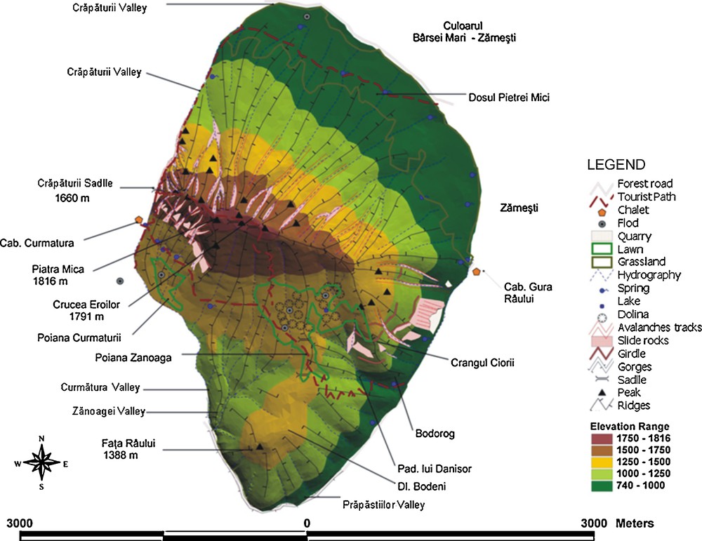
Piatra Mica is a well-structured, complex and outstanding massif lying in the northeastern part of the Piatra Craiului mountain range, which is situated in the extreme East of the southern Carpathians (the central part of the Romanian territory). Seen from the north, it is very impressive, showing distinct slopes on all sides, but with different features, which mirror the local conditions (Fig. 1). The massif runs from east to west, that is, perpendicular to the main ridge of the Piatra Craiului mountain range, which develops from northeast to southwest. From the point of view of the physical features, it represents a transition unit between the Piatra Craiului Mare massif, on the west, and the Rucar-Bran corridor and the Magura Mica, on the east. The borderlines to the neighboring units are sharp, in as much as they correspond to two main faults, whose alignments are highlighted by two streams, namely the Valea Crapaturii to the northwest and the Valea Prapastiilor to the east (Constantinescu and Piţigoi, 2003). The other boundaries are represented by the Barsa Mare-Zarnesti corridor to the north and northeast, the Crapatura saddle (1660 m) to the west, and the Valea Zanoagei and Padina lui Calinet brooks to the south (Constantinescu, 1994; Munteanu, 2008) (Fig. 1).

The geographical position of the Piatra Craiului mountain range within Romania and the southern Carpathians (left). The location of the Piatra Mica massif within the Piatra Craiului mountains (right) (Munteanu, 2008).
Position géographique de la chaîne de montagne de Piatra Craiului en Roumanie et dans les Carpathes méridionales (à gauche). Localisation du Massif Piatra Mica dans la chaîne de montagne de Piatra Craiului (à droite) (Munteanu, 2008).
Following different studies on mountainous rock slope destabilization (for example, Guglielmi et al., 2005) and attempts to model the avalanche flux by a growing function of the slope (Devauchelle et al., 2008, and references therein), the authors present here, in the Romanian Carpathians, studies concerning the snow avalanches which have appeared only recently, which is the reason why there are not enough historical and statistical data available at the moment. This is also the case for the Piatra Mare massif (2.1 km2), for which published information is scarce and of recent date. In fact, the avalanches have only been mentioned in the specialty studies dealing with the Romanian mountain realm as being an important and active landform-shaping factor, but until recently, they have not been analyzed thoroughly and systematically (Constantinescu, 2006; Moţoiu and Munteanu, 2006; Munteanu and Constantinescu, 2006). Clear evidence of the occurrence of such phenomena can be seen all over the place, but this is the first study that primarily analyzes the geomorphological factors, which are responsible for the dynamics of vulnerable areas, and not only the climatic ones, seen as a necessary condition for avalanche occurrence. Likewise, the biological and anthropogenic factors are also taken into account, not only from the perspective of their way of expression, but also from the standpoint of the impact, they suffer in the aftermath of such unwanted events. So far, the common knowledge has it that in the investigated area, no human loss has been reported, the only damage being the periodical destruction of the forest fund. However, this negative phenomenon has not been assessed completely yet.
This article makes a detailed analysis of the dynamics of avalanche-affected areas for each and every slope (with northerly, easterly, southerly and westerly aspect). The Piatra Mare massif is a complex subunit, offering good conditions for avalanche occurrence, especially due to the different slope aspects. As far as the climatic conditions are concerned, which are typical for a middle-altitude mountain unit, they definitely act in a different manner for each investigated slope aspect (Fig. 2). The results explain how the avalanches affect the landscape, but at the same time, they emphasize the dynamics of the avalanche-affected areas within this mountain unit with distinct geomorphological features. In the next place, we will expose in detail the used methodology, which is based on a good knowledge of specialised literature, but especially of the field by repeated campaigns, as well as by the use of some cartographic materials (different scales maps, aerophotograms, ortophotoplans). A series of maps in GIS (Arc View 3.2 program) were made, in the first stage analytical maps, then resulting in synthesis maps in order to develop the dynamic in time of the avalanches and of the forms generated by their action.

The Piatra Mica massif–Aspect-slope map.
Massif de Piatra Mica–Carte de l’aspect et des pentes.
2 Methodology
The investigation employed a series of research and analytical methods specific for the study of avalanches and current geomorphological processes. They helped the identification of the vulnerable areas, where proper conditions for avalanche occurrence exist. In our endeavor, we relied heavily on the measurements and observations undertaken in the field, but also on the analysis of the existing cartographic documents: topographic and tourist maps of various scales and editions, aerial photographs, orthophotoplans, satellite imagery and photos, DTM at 90 m resolution, topographic maps, scale: 1:50 000, landuse and landcover maps, weather stations for the climatic data, geological maps. All the available information was processed by using the GIS techniques, according to the literature (Ancey et al., 2003; Johnson and Smith, 2010; McClung, 2001, 2002; Munteanu, 2006, 2009; Pietri, 1993; Simenhois and Birkeland, 2010; Voiculescu, 2002, 2004; Voiculescu and Vuia, 2004). Particular attention was given to the processing of IKONOS 2004 satellite imagery, using the ArcView 3.2. software, which allowed the development of the maps presented in the paper.
The way the avalanches affect the landscape was particularly taken into account. From this point of view, the studies consisted in mappings in the field in various periods of the year and in investigations meant to highlight the avalanche-prone areas. At the same time, efforts were made to establish the dynamics of the avalanche chutes, gravitational processes, screes and torrential streams, but also to explain the avalanche effects on topography and forest vegetation.
To better understand the avalanche occurrence, all the components of the natural setting that are responsible for the vulnerability of the area to such disruptive events were analyzed: geomorphological features, exposition, slope, climatic parameters and hydrography. The results were further correlated with the local features controlling the distribution of vegetation, but also with the anthropogenic factors. Besides, we tried to establish how this array of conditions could influence the dynamics of the avalanche-affected areas.
A great part of the information used for this study was provided by the Administration of the Piatra Craiului National Park, the Mountain Rescue Service, the Forest Services in the area, the chalet keepers, the mountaineers, and the NGO members that carry on various activities in the investigated perimeter.
3 Results and discussions
In the following, we will make a thorough analysis of the final results by presenting the existing situation of the study area, the avalanche control factors, and the dynamics of the avalanche-affected areas, which have different rates of development depending on the slope aspect.
3.1 Avalanche natural triggers
The main controls that trigger the nival processes are the geological, morphological, climatic, biotic, and sometimes even the anthropogenic conditions. All these are closely connected to one another and, therefore, they strongly influence the avalanche occurrence. Avalanche magnitude can easily be ascertained from the traces left behind on slopes (Hervas, 2003; McClung, 2001).
3.1.1 The general morphology of the Piatra Mica massif
This, expressed by its pyramidal shape and the existence of a ridge exceeding 1700 m altitude, encourages avalanche occurrence. The main summits are Piatra Mica (1816 m) and Crucea Eroilor (1791 m), both of them representing important tourist attractions, even in wintertime, when avalanche vulnerability poses a threat to their lives. The steep slopes are scarred by many valleys, which often turn into avalanche chutes. Along the thalwegs and at their lower ends talus cones show up, the appearance of which is determined by the slope aspect (Figs. 2 and 3). The study area shows five major hypsometric steps (Fig. 4), as follows: the upper step (1750–1816 m) corresponding to the zone where snow accumulates and avalanches come into existence whenever the ridge cornices break up; the middle-upper zone (1500–1700 m), where avalanches may occur immediately after heavy snowfalls or where the snow coming from above slides down to the lower elevations; the middle-lower zone (1250–1500 m), which encourages snow transport and accumulation; the lower zone (1000–1250 m), which occasionally acts as a deposition area; and the step lying at the foot of the slopes (740–1000 m), which is outside the avalanche range (except for the avalanches that occur within the quarry lying on the eastern slope). The eroded materials, which are carried away and finally laid down by the avalanches, play an important part in the evolution of present-day morphology. Depending on the slope aspect and local typology, one can notice significant differentiations depending on the avalanche type (Munteanu, 2009) (Fig. 5).

The Piatra Mica massif–Slope map.
Massif de Piatra Mica-Carte des pentes.
The Piatra Mica massif–Morphological map showing the avalanche chutes.
Massif de Piatra Mica-Carte morphologique montrant les chutes d’avalanches.
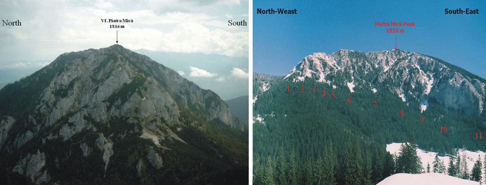
The Piatra Mica massif–The appearance of the western slope (left) and 11 of the 15 avalanche chutes on the southwestern slope (right).
Massif de Piatra Mica–Aspect de la pente ouest (à gauche) et 11 des 15 chutes d’avalanches sur la pente sud-ouest (à droite).
3.1.2 The geological substrate
This is typical for the entire mountain range. It is less rugged and, therefore, extremely favorable for snow sliding (Munteanu, 2009). In the upper area, the Kimmeridgian-Tithonic limestones prevail and, consequently, the slopes are steep, with grades exceeding 40°. Here, one can see many torrential streams, creeks and chimneys, which encourage avalanche formation (Figs. 3 and 4). In the lower area lying southwards, the landforms develop on Vraconian-Cenomanian conglomerates. At the base of the slopes underlain by limestones, they are sometimes covered by Quaternary deposits, mobile at the top and stabilized at the bottom. It is especially the case of the northern slope, where colluvial-proluvial deposits prevail, as it also happens on the northwestern side of the Piatra Mare massif (Constantinescu, 1994; Popescu, 1967). More often than not, these deposits are affected by avalanches, which either carve chutes or, on the contrary, pile up the materials detached from the upper parts. This largely explains the loose consolidation and the mobility of the scree fragments. As far as the slopes are concerned, they allow us to see the limestones structure, which is responsible for the valley and slope profiles. At the same time, however, the slopes represent a major control for avalanche occurrence and for the accumulation processes that influence the local morphology (Figs. 3 and 4). These features are also responsible for the differences existing among the slopes. Along the valleys, there are lithological and structural thresholds, which play an important part in avalanche triggering. Due to this specific geological substrate, most of the streams in the upper and middle parts of the Piatra Mica massif have a temporary flow regime, with nival and torrential character (Constantinescu, 1994). The waters resulting from snow melting and rainfalls flow swiftly on short distances before sinking into the ground, thus affecting periodically the local morphology. However, the hydrographic network continues to play the most important part in avalanche occurrence, in as much as it provides the necessary sliding paths (Munteanu, 2009).
3.1.3 Climatic conditions
By their distribution, quality and structure, climatic conditions are extremely important for the periodic movement of snow (Simenhois and Birkeland, 2010). In the case of the Piatra Mica massif, they turn into a major control for avalanche occurrence, due to the climatic parameters specific for the middle-height mountains and to the abundant winter snowfalls generated by the western and northwestern air masses. This amount of snow acts differently, depending on the local conditions, and especially on the exposition (Fig. 2). For instance, on the northern side of the massif, the snow lasts longer and, therefore, passes gradually through various phases, while on the southern slope, it disappears almost completely with the first rays of the sun. The wind is an element that encourages the formation of cornices along the sharp ridges and on the windward sides. In winter, at the base of the mountains, temperatures range between −2 and −4 °C, while at higher elevations, they drop even further to −6 °C at 1400 m and −8 °C at 1800 m. The freezing days generally occur from September till May, with a higher frequency and a longer duration on the northern slope. In winter, thermal inversions are common, especially in the north-northeastern part lying between the northern slope of the Piatra Mica massif and the Zarnesti depressionary inlet, belonging to the larger Brasov Depression. As a result, the snow lasts longer at the foot of the mountains. The annual amounts of precipitation reach 960 mm, of which 30 to 70 mm fall in wintertime. From January till March, the snow cover in the Curmatura area is about 80 cm thick. The snow blanket lasts on an average about 120 to 160 days per year, but there are significant differences between the slopes with various aspects. The longest interval is recorded on the northern side, while the southern and southwestern slopes have the fewest days with snow cover (Teodoreanu, 2006). All these findings prove beyond any doubt that the area is highly prone to avalanches.
3.1.4 The vegetation
The vegetation is important because it may encourage or hinder the avalanche occurrence. At the same time, it is an element that gives evidence of the events that have affected it. Thus, it preserves the traces of the avalanches that played havoc on significant areas. At the upper part, in the cryonival realm where avalanches originate (the starting zone), the vegetation is made up of alpine and subalpine formations. Below this area, lie the coniferous forests, then follow the mixed ones, while at the foot of the mountains the broadleaf forests prevail (Mihăilescu, 2001; Pop and Vezeanu, 2006). In the forest zone, the avalanche chutes develop along the valleys. On both sides of the thalwegs, one can see longitudinal strips devoid of vegetation, which testify the devastating effects of the avalanches (Figs. 6 and 7). Their overall impact on the forest vegetation is obvious, but the most significant effects are seen along these corridors and in the areas where the rock fragments carried by the snow accumulate. These effects have also been taken into account to define the areas where avalanche vulnerability is high (Munteanu, 2009).

The Piatra Mica massif–The northern slope (right) scarred by avalanche chutes.
Massif de Piatra Mica–Pente nord (à droite) marquée de chutes d’avalanches.

The features of a valley functioning as an avalanche chute lying on the northern slope of the Piatra Mica massif. The starting zone and the track (left). The track and the deposition zone lying in the mixed beech and coniferous forest (right).
Caractéristiques d’une vallée fonctionnant comme une chute d’avalanche sur la pente nord du massif de Piatra Mica. Zone de départ et tracé (à gauche). Tracé et zone de dépôt dans une forêt mixte de hêtres et de conifères.
3.1.5 Anthropogenic activities
Anthropogenic activities, such as tourism, grazing, wood harvesting and rock extraction are present, too, but each type of activity is encouraged or hindered both by the slope aspects and features, and by the slope morphology and accessibility. The most affected is the eastern slope, because of the existence of a quarry (at present disused) and a county road that connects Zarnesti and Magura settlements (Fig. 8). Here, almost all year round, frequent gravitational processes occur, which move the rock fragments to lower elevations. In summer, rock sliding and collapses prevail, whereas in winter, avalanches are the most common form of mass movement. The latter are extremely dangerous for tourism, as well as for the traffic along the above-mentioned county road (Munteanu, 2008).

The Piatra Mica massif–The southeastern and eastern slopes with the quarry exploitation (left) and detail of the limestone quarry (right).
Massif de Piatra Mica–Pentes sud-est et est, avec une exploitation de carrière (à gauche) et détail de la carrière de calcaire (à droite).
3.2 The dynamics of the avalanche
The dynamics of the vulnerable areas has been analyzed separately for each and every slope, in order to assess their present condition and to understand the way they behave. At the same time, the differences occurring among the various slopes have been identified.
3.2.1 The northern slope
This is more uniform than the others and due to its aspect and the relative isolation from the rest of the massif (Figs. 4 and 5), it is significantly called the Dosul Pietrei (The Back of the Rock). At the upper part, the slope is dissected by a series of valleys, glens and chimneys, some of them functioning as avalanche paths, which also affect the forest zone lying below, where the gradients decrease to 30–40°. At lower elevations, gradients drop to less than 20°. It is the case of the colluvial deposits area, which stretches as far as the Barsa floodplain, in which the river has cut several terraces, some of them leveled by man and cleared in order to encourage the extension of pastures (Figs. 6 and 7). On this slope, 12 avalanche chutes, 800 m long and 20 to 50 m across, were identified, whose deposits are found at 1150 m altitude. The valley lying in the central part of the massif, to the northeast of the Crucea Eroilor peak, is a typical example of a valley functioning as an avalanche chute. Its catchment area consists of several glens and chimneys, which end up in the S-shaped thalweg. At its origin, there is a small basin-like depression, which is crossed by three torrential streams that join together upstream a short gorges section (15 km long). Downstream of it, the valley morphology changes, because it turns into a large corridor, 50 to 80 m across, which runs as far as the foot of the calcareous slope (at about 1000 m altitude). The appearance of these valleys shows that the avalanches that are channelled along their thalwegs with well-defined functional characteristics may descend as low as the forest zone, as is indicated by the marks left on the vegetation cover (Figs. 6 and 7).
The northern slope is particularly affected by spring avalanches (Munteanu, 2009).
3.2.2 The eastern slope
The eastern slope exhibits calcareous outcrops dissected by chimneys, glens and torrential streams, which can channel the flowing snow, especially immediately after heavy snowfalls. The base of this slope is profoundly affected by anthropogenic activities, in as much as here are found two disused limestone quarries, with lengths of 300 and 100 m, respectively (Fig. 8). The limestone extraction disturbed the natural balance of the slope and triggered gravitational processes, such as rock and snow avalanches and collapses, which negatively impact the Zarnesti-Magura county road. During the wintertime, in the aftermath of short and heavy snowfalls, the road is obstructed by avalanches. At the same time, because the local people keep extracting the rocks from the disused quarries the pine plantation, meant to stabilize the slope, is systematically destroyed. Avalanches usually occur at the upper part of the ridge, and especially to the southeast and northeast, where two steep secondary edges exist, separated by valleys with thalwegs tilting more than 40° (Figs. 3 and 8). Likewise, one can see cross structural benches, of which the most significant is the Crangul Ciorii (Munteanu, 2008). Generally, the avalanches are small, but after heavy snowfalls, they rush down the glens cut in the scree deposits, cross the woods and finally reach the trunk valley and the county road (Munteanu, 2009).
3.2.3 The southern slope
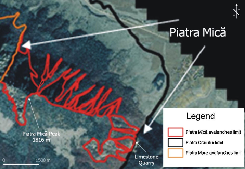
The southern slope is divided into two distinct parts by a secondary sharp ridge stemming from the Piatra Mica summit. The eastern section is larger and forested nearly to the ridge-top, the avalanche vulnerability being consequently lower. On the other hand, the western part (Figs. 5 and 8) is favorable for avalanche occurrence. In general, this slope is rather similar to the eastern side of the Piatra Mare massif, but on a smaller scale (Moţoiu and Munteanu, 2006). The presence of calcareous cliffs arranged in amphitheater form and dissected by glens, chimneys and small valleys creates the best morphological conditions for avalanche occurrence. In the upper half, where gradients exceed 60° (Fig. 3), the most impressive is the eastern slope, suggestively called Peretele Galbenoasa (The Yellowish Wall), which stems from the main summit (Cristea, 1984). At the base of the limestones, there are talus cones that penetrate the forest. Throughout the entire area, 15 avalanche chutes (Fig. 5) of various sizes (between 50 and 250 long, and 20 to 150 m across) were identified, which show many torrential streams in their starting zone. On their way, the chutes cross the lithological thresholds and at their lower ends, the flowing snow piles up the carried materials on top of the mobile screes. Thus, the areas made up of conglomerates scarred by glens are the most affected by avalanches (Munteanu, 2009). Such phenomena occur along well-defined paths, but also on the entire calcareous slope surface. Due to the southeastern aspect, snow melts rapidly and avalanches are small or middle-sized. Big avalanches occur only after heavy snowfalls. They can reach as far as the tourist track connecting the Curmatura chalet and the Crapatura saddle, more exactly in a section located immediately before the saddle. In-between the scree deposits and at their base, the coniferous forests act as a barrier against the flowing snow. Consequently, the forest zone marks the lower end of the morphological effectiveness of snow avalanches. The southern slope gradually dips to the south, as far as the Crapatura valley. Along it, one can see several structural steps, made up of limestones in the upper part and conglomerates to the base, which drastically reduce the avalanche vulnerability (Constantinescu, 2009).
3.2.4 The western slope
The western slope shows talus cones at the base, more conspicuous in the vicinity of the Crapatura saddle (1660 m), where gradients usually reach 30° (Figs. 3, 5 and 8). From this large saddle, a sharp ridge stems to the east, which is nothing else than the main interfluve of the Piatra Mica massif. In its turn, this splits to the south and north into secondary interfluves dissected by glens. Thus, to the southwest, immediately below the crest line, lies a cliff developed on limestones, with gradients exceeding 50°, which marks the avalanche-starting zone. Here, the avalanches are relatively short, especially because of the slope aspect, which encourages an earlier snow melting (Figs. 3 and 5). To the northwest, however, there are several crags (Acul Crapaturii, Manusa Crapaturii) separated by glens and chimneys, which end up in the Crapatura valley (Constantinescu, 1994). This valley that separates the Piatra Craiului Mare and the Piatra Mica massifs has several tributaries originating in the starting zone, which carry the rock fragments detached by the avalanches piling them up occasionally on the bottom of the trunk valley in the form of alluvial fans.
All the slopes discussed so far have avalanche-prone areas the dynamics of which is controlled by the local conditions. The findings of this study have resulted in the development of the Avalanche Hazard Map for the Piatra Mica massif (Fig. 9), which may be further employed for identifying and solving the problems raised by the avalanches. At the same time, all this information may be taken into account by the local authorities in their endeavor to improve and better manage the mountain realm. From this point of view, we recommend that no intervention be made, because the preservation of the initial natural conditions is a must and is the only way to prevent the degradation of the natural environment and to ensure its sustainable development.
The Piatra Mica massif–Avalanche Hazard Map.
Massif de Piatra Mica–Carte des risques d’avalanches.
4 Conclusions
Although the area and elevations are relatively low, the Piatra Mica massif shows morphological and morphodynamic features extremely favorable for avalanche occurrence. In other words, avalanches are the most widespread contemporary geomorphological processes in the area. Their size, features and effectiveness depend on aspect, gradient, morphology, precipitation, solar radiation, and forest vegetation and, to a lesser extent, on human activities. The avalanches act differently, especially because of the slope aspect, but also because of the specific features of the triggering factors. The cyclical occurrence and the variable effectiveness of the avalanches are also responsible for the increasing of scree dynamics and the alteration of vegetal cover. All these facts show a high potential for avalanche occurrence, a phenomenon having a strong impact on the general dynamics of the components of the natural environment. In our opinion, the avalanches and their associated effects should be further monitored and investigated, but without interfering with the natural processes, as long as they do not pose an immediate threat on human beings and society.
The present article is a starting one for the analysis of the avalanches from the Romanian Carpathian space. It is for the first time when the local conditions which determine the dynamic of areas with avalanches from a mountainous subunit are analysed. Therefore, it may be a first important step to delimitate the areas vulnerable to avalanches, the basis of some dendro-geomorphological studies, for chronological evaluation of avalanches, GIS analyses of the corridors and of the vulnerability of mountainous space to these processes, which will contribute for certain to the development and knowledge of these problems, which are important in the mountainous space.
Acknowledgements
This work was supported by the strategic grant POSDRU/89/1.5/S/58852, Project Program for postdoctoral researchers in science education, co-financed by the European Social Fund within the “Sectoral Operational Program Human Resources’ Development 2007–2013”, and the project: “Evaluation and Monitoring of Avalanche Risk in the Context of Mountain Environment Organising and Planning. Case Study–Fagaras and Piatra Craiului Mountains”, financed by CNSIS, category IDEI. We wish to express our appreciation to all those who supported us in the documentary and field investigations: the Administration of the Piatra Craiului National Park, the Rescue Service in Zarnesti, the Curmatura chalet keepers and the members of the Liliecii Brasov NGO. The authors’ contributions are equal.