

1 Introduction
As pointed out by many authors (Lecomte, 1988; Schwartz, 1996; Vogt and Vincent, 1966), the profiles of surficial formation in western Central Africa (Gabon, Congo) display a very constant organization including three superposed units (Fig. 1):
- • the variably altered local basement (saprolite to fresh rock);
- • an intermediate coarse-grained layer known as the ‘Stone Line’, made of more or less reworked lithic elements (including human artefacts);
- • an upper sandy to clayey homogeneous horizon of yellow to red colour known as the ‘Cover Horizon’.

Schematic sketch showing the spatial organization of surficial formations over the Gabonese territory. Modifications from the representation proposed by Vogt and Vincent (1966) include: (i) the incision of the whole profile in the valley bottoms along the rivers; (ii) the common absence of weathering (saprolitization) of the basement below the surficial formations; (iii) the occurrence of isolated boulders of fresh basement rock within the Cover Horizon.
Représentation schématique de l’organisation spatiale des formations superficielles sur le territoire gabonais. Relativement au schéma proposé par Vogt et Vincent (1966), les principales modifications portent sur : (i) l’incision des profils de formations superficielles dans les fonds de vallées le long des rivières actuelles ; (ii) l’absence commune d’altération (saprolitisation) du substrat rocheux sous les formations superficielles ; (iii) la présence de blocs isolés de roches fraîches issues du substrat rocheux au sein de l’Horizon de couverture.
The thickness of each of the upper two layers is generally around 1 to 2 m but reaches 10 m or more in the coastal basins of Congo and Gabon, where the yellow sandy layer appears to be spread over Mesozoic sedimentary rocks or Pliocene to Pleistocene sands (Thiéblemont, 2013; Thiéblemont et al., 2009).
Outside western Africa, profiles that show the superposition of a lower coarse-grained unit and upper sandy clayey cover appear as an almost constant feature of inter-tropical regions (Alexandre and Soyer, 1989; Vogt and Vincent, 1966) and their formations have fed an intensive scientific debate for more than 50 years. Crucial in this debate is the precise knowledge of the interval of time necessary for the formation of the profiles.
The frequent occurrence of archaeological artefacts in these profiles provides a first approach to this problem. In western Central Africa, the lithic industry recovered in the Stone Line is of Old to Middle Stone Age (Locko, 1991), thus suggesting a rather young age (i.e. ≤ 40,000 BP) for the upper part of the profiles (Schwartz, 1996). However, the interpretation of this time constraint is strongly dependent on the model adopted for the formation of the profiles, and strongly different models do exist which lead to strongly different interpretations. Amongst many others, a fundamental difference between models concerns the role of biogenic activity. Assuming a major role to this activity leads to the conclusion that the present organization of the profiles has nothing to do with stratigraphy thus precluding the use of the superposition law to constrain the relative age of the two superposed (therefore not successive) units (Johnson, 2002).
Quantitative constraints on the age of the profiles may be derived from 14C dating, especially when such a method is applied to charcoal fragments these latter being present at all levels of the profiles. The 14C age obtained may be considered as the oldest possible age provided that the charcoal fragments were included in the profile during its formation.
In the follow-up of the Colloquium held in Paris 1–2 march 2012 on the Upper Holocene environmental crisis in African forests (Elenga et al., 1992; Maley and Brenac, 1998; Schwartz, 1992; Vincens et al., 1998), the purpose of this paper is to present new 14C geochronological data obtained on the surficial formations of Gabon which suggest a close relationship between these formations and the environmental crisis.
These data were obtained in the frame of a geological mapping project of Gabon sponsored by E.U. (Sysmin Funds) and the Gabonese Ministry of Mines. From a sedimentologically-based interpretation of the surficial formations, Rigollet and Thiéblemont (2009), Thiéblemont et al. (2009) and Thiéblemont (2009, 2013) came to the conclusion that some kind of climatic collapse would have affected Gabon during recent Quaternary times (Rigollet and Thiéblemont, 2009). Thus, the 14C data present in this paper are used to build a scenario connecting the geological events with climatic and environmental changes.
2 Methodology and sample collection
2.1 Field investigations
The geochronological data presented in this paper were obtained from charcoal fragments sampled in the Stone Line and Cover Horizon during the course of the geological mapping project (2005–2009). The area concerned by this project covered about two thirds of the whole Gabonese country, mainly in its central and eastern parts where the geological basement is composed of Precambrian terrains of Mesoarchean to Neoproterozoic age (Thiéblemont, 2009; Thiéblemont et al., 2009). Field studies were performed during seven campaigns (2005–2009), which covered the short (January–March) and long (June–October) dry seasons. We thus spent about 1.5 years in the field, accumulating a very large number of observations and photographs, some of these latter being available at the address: http://medihal.archives-ouvertes.fr/(common title ‘Holocene geology of central Africa’).
During the mapping project, the 1–3 m-thick layer of fine-grained material of yellow to red colour was almost everywhere observed, in close agreement to the common definition of the Cover Horizon as a homogeneous horizon blanketing the landscape. However, field observations lead us to bring some significant modifications to the classical model (e.g. Vogt and Vincent, 1966) (Fig. 1). Along the rivers, we noted that the whole profile, i.e. the Stone Line and Cover Horizon, appeared frequently incised (Fig. 2) suggesting that at some time, even the present-day valley bottoms were covered by surficial formations. Collapse of the soft cover material by gravitational sliding along the flanks of denuded hills (Fig. 3) provides another evidence of the present-day erosion of the Cover Horizon. In some places, we observed large boulders (e.g. up to 1.5 m in size) of fresh rock (especially quartzitic sandstones) isolated within the Cover Horizon.
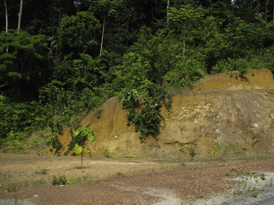
View showing the incision of the Cover Horizon on the valley flank of a small river (on the left). The yellow layer covers all the landscape around but is incised along the riverbed. Along such river beds the largest Stone Line blocks are left on the spot after washing of the medium- to fine fraction. Mitzic region, Gabon. Color available on the web.
Vue montrant l’incision de l’Horizon de couverture sur le flanc de vallée d’une petite rivière (sur la gauche). La couche jaune nappe tout le paysage alentour, mais elle est incisée le long du lit de la rivière. Sur de tels lits, on observe couramment les blocs les plus volumineux de la Stone Line, laissés sur place après érosion des fractions fines. Région de Mitzic, Gabon.
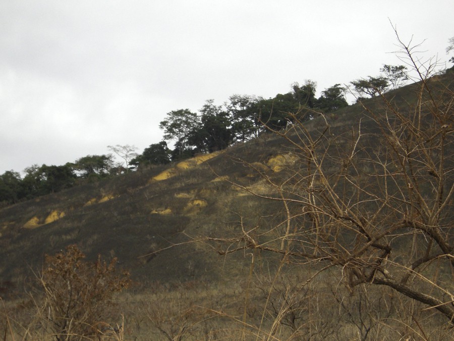
View of a savanna hill showing evidences of the present-day erosion of the Cover Horizon by gravity sliding. Nyanga Basin, Gabon. Color available on the web.
Vue montrant un flanc de colline affecté par des glissements en masse dans une zone de savane. Bassin de la Nyanga, Gabon.
Below the Cover Horizon a Stone Line of variable composition and facies was observed. The sedimentological study revealed a large range of depositional features consistent with a sedimentary reworking (Rigollet and Thiéblemont, 2009). Examples of ‘superposed’ or ‘stratified’ stone-lines were never observed, which could suggest that emplacement had proceeded by successive episodes. This let us to suggest that Stone Line reworking should have been associated with a unique geological event in particular climatic conditions (Rigollet and Thiéblemont, 2009). Artefacts were observed in many places (Thiéblemont et al., 2009) but not subject to a detailed study. The thickness of the Stone Line varied from place to place, being locally restricted to isolated blocks overlying the basement rock. The rate of weathering of this basement varied strongly from place to place, and in some outcrops, a fresh basement was observed below the surficial formations (Fig. 1). In some places, no Stone Line was present and a massive basement was observed directly below the Cover Horizon (Fig. 1). From such outcrops, we found that the large boulders observed in the Cover Horizon resulted from the lateral reworking of rocks derived from the dislocation of the roof of the basement rock.
In different places, we observed alternating Stone Line and Cover Horizon layers in the intermediate part of profiles (see also Schwartz and Lanfranchi, 1993 and refs. therein), on the other hand, we never found clearly distinct superposed stone-lines as described in DRC (Rünge, 2001).
2.2 Sampling
Sampling of the Cover Horizon was first aimed to give a representative picture of the sedimentological and geochemical variability of this unit (considering it as a deposit) at a regional scale. Samples were collected in six regions with contrasted basement geology, spread over the whole Gabonese territory (Fig. 4). In some outcrops, we collected up to five superposed samples more or less regularly spaced from the bottom to the top of the profile. Granulometric, geochemical and isotopic (Thiéblemont et al., in prep.) data were obtained on a collection of about 30 samples, which let us to conclude to the aeolian origin of the Cover Horizon (Thiéblemont et al., 2009; Thiéblemont, 2013). The occurrence of charcoal fragments in a significant number of places gave us the opportunity to perform 14C analyses.
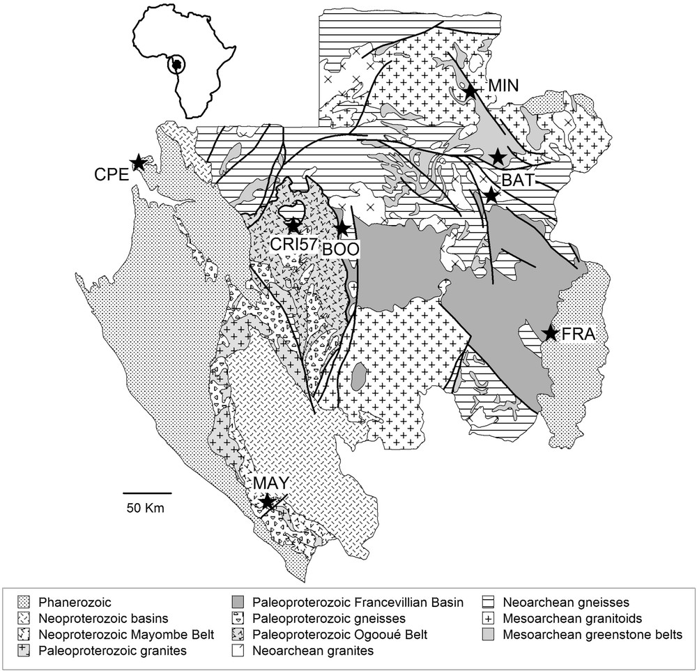
Simplified geological map of Gabon showing the location of the sites selected for sampling of the Cover Horizon. Modified from Thiéblemont (2013).
Carte géologique simplifiée du Gabon, avec report des sites ayant fait l’objet d’un échantillonnage détaillé de l’Horizon de couverture. Modifié d’après Thiéblemont (2013).
On one outcrop (CRI57), we found large charcoal fragments isolated in the Cover Horizon (Fig. 5) about 1 m below the surface. The other occurrences of charcoal fragments were observed in two widely separated areas:
- • close to the Atlantic coast in the Cap Esterias region (CPE site on Fig. 4);
- • on the ridge and flank of the Minkéké Mounts in the northeastern part of Gabon (MIN site on Fig. 4).

View showing dispersed charcoal fragments within the Cover Horizon about 1 m below the surface. CRI57 site, Mitzic region, Gabon. Color available on the web.
Vue montrant des fragments de charbon de bois d’assez grande taille, dispersés dans l’Horizon de couverture, à environ 1 m sous la surface. Site CRI57, Région de Mitzic, Gabon.
A synthetic log of one of the profile in the Cap Esterias region is reported on Fig. 6.
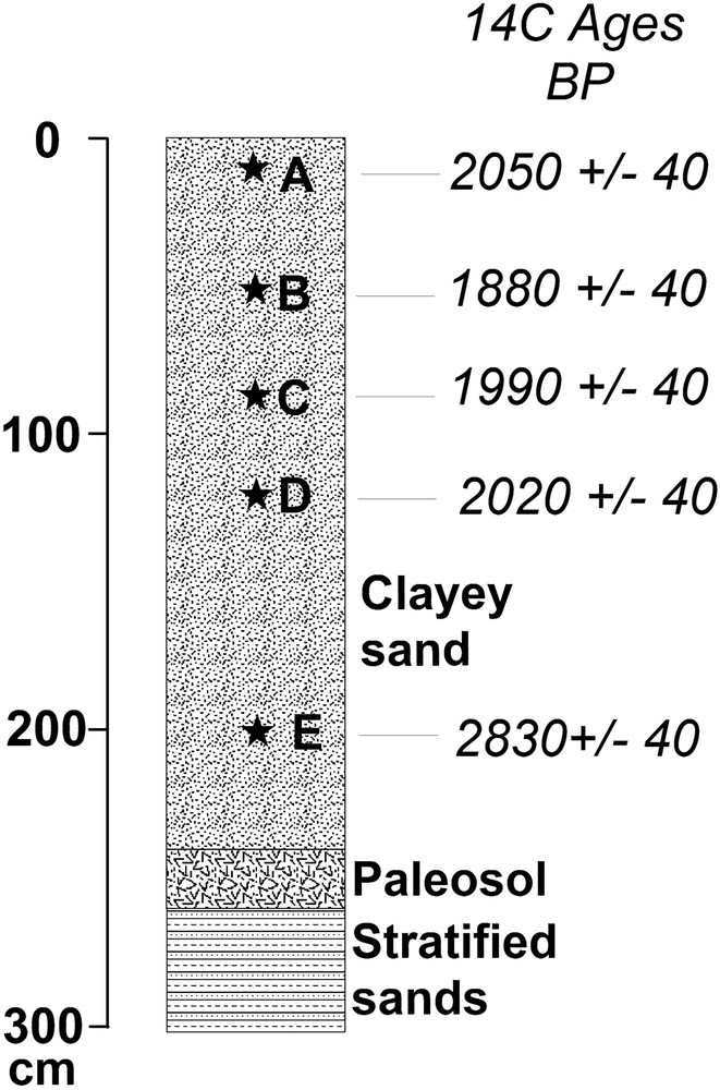
Schematic log at the CPE0001 site showing the location of the five superposed samples selected for analyses. The Cover Horizon on this outcrop site is very homogeneous (Thiéblemont, 2013) except in the uppermost part (CPE0001A sample) where humic matters give the clayey material a brown color. Note the decreasing of ages at decreasing depth from sample E to sample B. The relatively old age at the top of the section (A) may reflect lateral reworking of charcoal fragments brought to the surface by biological (e.g., termites) or anthropic (e.g., excavation) processes.
Log schématique du site CPE0001 montrant la position des cinq échantillons superposés prélevés pour analyse. L’Horizon de couverture est très homogène (Thiéblemont, 2013), sauf dans la partie supérieure (échantillon CPE0001A) où des matières humiques confèrent au matériel argileux une teinte brune. On notera la décroissance des âges de bas en haut entre les échantillons E et B. L’âge relativement ancien au sommet (A) pourrait traduire le remaniement latéral de charbons ramenés à la surface par des processus biologiques (termites) ou anthropiques (excavation).
The CPE0001 site is located in a very flat zone and shows a homogeneous layer of yellow sandy material covering stratified sands of probable Plio-Pleistocene age (Cirques Series). An oxidized zone at the top of these sands is interpreted as a palaeosol and no Stone Line is observed. Five samples were collected from the bottom to the top of the profile (Fig. 6). They show a rather homogeneous granulometric (Table 1) and geochemical composition being essentially composed of fine-grained quartz sands (∼ 56–66%), with silts (∼ 11–23%), clays (∼ 16–20%) and minor coarse sands (∼ 4–6%). All these samples contain charcoal fragments in the 1 to 5 mm granulometric range.
Résultats des analyses granulométriques sur sept échantillons ayant fait l’objet de datations 14C.
| Granulometric range | MIN 0040 | MIN 0041 | CPE0001E Bottom |
CPE0001D | CPE0001C | CPE0001B | CPE0001A Top |
| Clay (≤ 4 pm) | 84.30 | 92.59 | 16.26 | 20.41 | 22.45 | 18.99 | 15.86 |
| Sitt (4–63 um) | 9.89 | 4.87 | 11.30 | 15.27 | 14.35 | 16.18 | 22.82 |
| Fine sand (63–200 um) | 2.86 | 0.71 | 66.28 | 59.70 | 58.81 | 60.20 | 56.51 |
| Coarse sand (0.2–2 mm) | 2.95 | 1.83 | 6.16 | 4.61 | 4.38 | 4.63 | 4.80 |
One of the samples (MIN0041) from the Minkébé area was collected close to the ridgeline of the mountain (altitude 520 m) by digging the ground. A discontinuous horizon of small charcoal fragments within a homogeneous yellow clayey material was observed about 15 cm below the surface. On the eastern flank of the mountain (altitude 640 m), charcoal fragments were revealed about 1 m below the surface owing to the presence of a collapsed tree (sample MIN0040). The Cover Horizon in these two places shows a homogeneous granulometric and geochemical composition, being essentially composed of clays (∼ 84–93%) with silts (∼ 5–10%) and minor fine and coarse sands (< 3%).
The contrasted nature (despite similar aspect and stratigraphical position) of the Cover Horizon at the two places has been attributed to two factors (Thiéblemont, 2013):
- • the reworking of local sand derived from the underlying Cirques Series in the Cap Esterias region;
- • the increasing proportion of fine-grained particles with the altitude.
Sampling of the Stone Line for dating purpose was carried out in only one site in eastern Gabon (Franceville region, Fig. 4) where charcoals occur as fine fragments intimately mingled with the sandy matrix. Human artefacts are especially frequent in this region and were actually observed (silex splinters and an entire quartz tool) at the site.
3 Results
The 14C dating were performed in a total of 11 charcoal fragments and duplicated at one site (MIN0040). They were analyzed in the Beta Analytical Inc. Laboratory (Miami, USA) according to the AMS-standard procedure, including acid/alkali/acid pre-treatment. The results are listed in Table 2, expressed as conventional 14C ages in years BP and recalibrated calendar ages. Because many of the 14C dates available in the literature referred to in the present study are not recalibrated, all the data exposed below are expressed as conventional ages.
Analyses 14C de fragments de charbons de bois échantillonnés dans l’Horizon de couverture et la Stone Line. Au site MAK1001, les fragments ont été observés en surface, associés à des scories de fer.
| Sample | δ13C vs. PDB ‰ (± 0.1) | Activity 14C pCM | Conventional 14C age in years BP (± 1σ) | Recalibrated calendar age (2 sigma, 95%) | Depth (cm) |
| Cover Horizon | |||||
| Cap Esterias | |||||
| CPE0001A | −26.4 | 77.5 ± 0.4 | 2050 ± 40 | 170 BC–30 AD | 10 |
| CPE0001B | −27.7 | 79.2 ± 0.4 | 1880 ± 40 | 50–230 AD | 50 |
| CPE0001C | −25 | 78.1 ± 0.4 | 1990 ± 40 | 60 BC–80 AD | 85 |
| CPE0001D | −25.7 | 77.8 ± 0.4 | 2020 ± 40 | 150–140 BC 110 BC–60 AD |
120 |
| CPE0001E | −25.1 | 70.3 ± 0.4 | 2830 ± 40 | 1120 BC–900 BC | 200 |
| Minkébé Mts | |||||
| MIN0040 | −26.9 | 75 ± 0.4 | 2200 ± 40 | 380–170 BC | 100 |
| MIN0040 | −25.3 | 76.8 ± 0.4 | 2120 ± 40 | 380–290 BC | 100 |
| MIN0041A | −29.4 | 98.1 ± 0.5 | 160 ± 40 | 1660–1960 AD | 15 |
| Lopé region | |||||
| CRI57 | −26.5 | 90.7 ± 0.5 | 790 ± 40 | 1170–1280 AD | 100 |
| MAK1001 | −25.4 | 92.6 ± 0.4 | 610 ± 40 | 1290–1420 AD | 0 |
| Stone Line | |||||
| FRA-CH1 | −26.7 | 51.8 ± 0.4 | 5290 ± 40 | 4230–4030 BC | |
| FRA-CH2 | −26.9 | 10.8 ± 0.4 | 17,800 ± 40 | 19,420–18,720 BC | |
| FRA-CH3 | −26.6 | 6.1 ± 0.4 | 22,490 ± 40 | Out of calibration |
The most interesting results were obtained at the Cap Esterias site. An upward decrease of 14C activity is observed from ∼−200 to ∼−50 cm depth, leading to four successive decreasing conventional ages: 2830 ± 30 BP (∼−200 cm), 2020 ± 40 BP (∼−120 cm), 1990 ± 40 BP (∼−85 cm) and 1880 ± 40 BP (∼−50 cm) (Fig. 6). At the upper part of the profile, a value of 2050 ± 40 BP is obtained from charcoal fragments sampled in the humic horizon.
Two contrasted but stratigraphically consistent measurements are obtained in the Minkébé region:
- • 2200 ± 40 BP and 2120 ± 40 BP (MIN0040) on the flank of the mountain at an approximate depth of −100 cm;
- • 160 ± 40 BP on the ridge crest and very close to the surface (∼−15 cm) (MIN0041).
At the CRI57 site, a value of 790 ± 40 BP is calculated from a large split charcoal fragment recovered some 100 cm below the surface.
Three different samples were selected amongst the fine charcoal fragments recovered in the Stone Line in the Franceville region. The highly variable 14C activity attested for varied ages with values ranging from 22,490 ± 40 BP, 17,800 ± 40 BP and 5290 ± 40 BP (Table 2). This latter is the most significant and corresponds to a calendar age of 4230–4030 BC (i.e. 6140 ± 100 cal BP), which we consider as the oldest possible age for the Stone Line emplacement (reworking event) at this site.
4 Discussion
4.1 Stratigraphic significance of the charcoal fragments
Crucial in the discussion of the significance of the 14C data is the interpretation of the Cover Horizon. Three propositions have to be considered:
- • a purely sedimentary origin;
- • a purely pedogenetic/biogenic origin;
- • a mixed origin involving the pedogenetic/biogenic reworking of a former sedimentary layer.
According to the first proposition, and whatever the depositional process is (e.g. aeolian or colluvial), the charcoal fragments can be interpreted as elements integrated in the fine-grained material in the course of its deposit and may thus indicate the oldest possible age for this deposit. This implies that the charcoals present at surface at a certain time were transported at the place where they are observed today and later buried owing to sediment accumulation.
According to the second proposition, charcoal fragments are integrated in the ‘soil’ owing to biogenic activity. For instance, a charcoal fragment initially present at surface may be integrated in a termite mound and later transported in any place of this mound.
According to the third proposition, charcoal fragments initially present at any level in the sediment may be transported downward or upward by varied biological or environmental processes such as growth of tree's roots, underground fauna activity or soil desiccation. In the second and third situations, a charcoal fragment may be younger that the material that surrounds it.
In the different sites we have studied, upward or downward migration of the charcoal fragments appears to us as very improbable. Indeed, the cover materials below the humic layer in all these sites shows a constant colour and grain size, with no indication of any biological or physical (e.g. illuviation) perturbation. This naked eye homogeneity is confirmed by granulometric and geochemical analyses (Thiéblemont, 2013, see also Table 1).
At the CPE0001 site (Fig. 6), the decrease of 14C activity from the bottom to the top of the profile, except the sub-surface sample CPE0001A (Fig. 6) may alternatively be interpreted as the consequence of the vertical accretion of the fine-grained material or downward migration of fragments within this material. The fragments were recovered from the coarser granulometric fraction (≥ 1 mm) being five to 20 times larger than the fine sand, which constitutes about 60% of the enclosing material. Downward migration of such large and light fragments by intense washing of the profile would lead to the accumulation of the finest particles in its lower part. The concentration of clay and silt is in fact higher in the upper than in the lower part of the profile (Table 1). The same arguments hold for the CRI57 site, where the 5 cm large dated charcoal fragment was sampled about 1 m below the surface (Fig. 5).
At the MIN0040 and MIN0041 sites an autochthonous nature of the charcoal fragments may be postulated from distinct arguments:
- • comparable 14C activity obtained from different fragments from the same outcrop (MIN0040);
- • occurrence of charcoals fragments as a discontinuous layer (MIN0041).
As far as the Stone Line is concerned, the hardness of the matrix at the Franceville site makes very improbable a migration of the charcoal fragments after the Stone Line emplacement.
From the above arguments, we consider that the 14C data obtained from the charcoal fragments sampled in the different sites in Gabon are stratigraphically significant, setting lower limits for the emplacement of the enclosing materials.
4.2 Timing
4.2.1 Cover Horizon
The new 14C data presented in this study indicate a very recent age for the Cover Horizon (< 3000 BP). Other data obtained from varied sites in Gabon and other countries in western Central Africa are available in the literature. Some of those data are from archaeological sites and will be considered separately, others are form charcoal fragments, seeds or total organic matter sampled at different levels in the Cover Horizon.
Recently, Morin-Rivat et al. (2012) presented 37 new 14C dates from different sites in northern Congo and southeastern Cameroon. These dates were obtained from charcoal fragments and seeds recovered from 30 150–200 cm deep pits excavated under different vegetation covers. Out of the 37 14C dates, 36 range from 2300 to 250 cal BP, and one is significantly older (15,200 cal BP).
In Gabon (Makokou region), Bayle des Hermens (de) (1990) reported 14C conventional ages of 3250 ± 80 BP and 2760 ± 60 BP for two charcoal beds revealed by digging pits in the forest soil. Peyrot et al. (2003) mentioned a 14C data of 3065 ± 50 BP for tree remnants sampled 80 cm below the surface on the Yindo Mnts.
In DRC (Haute Luilu region), Roche (1989) reported two 14C conventional ages for samples (charcoals?) obtained at depths of −220 cm (2120 BP) and −200 cm (1940 BP) in the clayey sandy cover.
In Congo (Mayombe region), Schwartz et al. (1990) obtained three 14C data (total organic matter) from soil samples located at −50–70 cm (720 ± 60 BP), −100–140 cm (1180 ± 60 BP) and −140–170 cm (1470 ± 60 BP) below the surface. The latter data is considered by the authors as the youngest possible age for the emplacement of the soil material.
All those data are perfectly consistent with those we have obtained in Gabon as the great majority of them (just one exception) preclude that the soft part of the regolith (i.e. the Cover Horizon) could be older that c. 3000 BP.
To complement the data from soils, we have compiled 133 14C conventional ages from archaeological sites from Gabon, Cameroon and Congo. These data are reported as a histogram (Fig. 7). As a whole, they range from c. 40,000 to 400 BP with a very pronounced maximum around 2000 BP and high frequency from 2600 to 1400 BP.
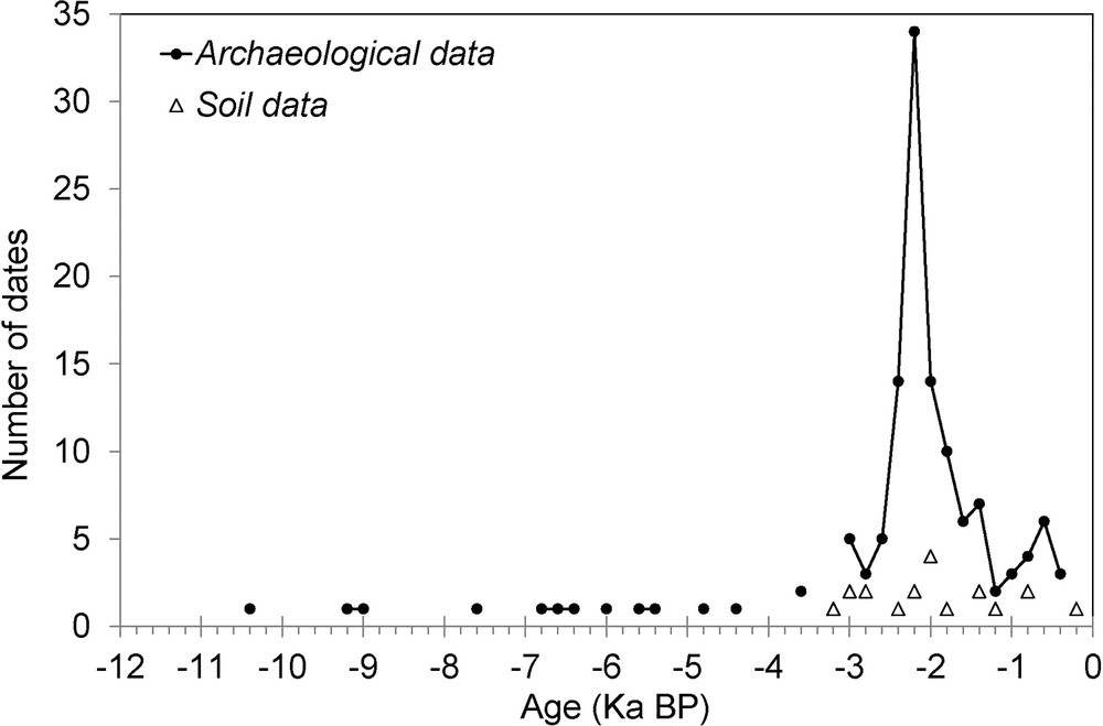
Comparison between the 14C ages obtained from archaeological sites and those obtained from soils (charcoal fragments or total organic matter), compiled from the literature (Gabon, Cameroun, Congo). References: Clist (1990, 1997), Holl (1991), Locko (1990), Maret de (1990), Jézégou and Clist (1991), Pinçon (1990), Lanfranchi (1991), Oslisly and Dechamps (1994), Oslisly et al. (2006), Oslisly and Assoko Ndong (2006), Peyrot et al. (2003), Schwartz et al. (1990).
Comparaison entre les âges 14C obtenus sur des sites archéologiques et sur des sols (fragments de charbon ou matière organique totale) issus de la littérature (Gabon, Cameroun, Congo). Références : Clist (1990, 1997), Holl (1991), Locko (1990), Maret de (1990), Jézégou et Clist (1991), Pinçon (1990), Lanfranchi (1991), Oslisly et Dechamps (1994), Oslisly et al. (2006), Oslisly et Assoko Ndong (2006), Peyrot et al. (2003), Schwartz et al. (1990).
The oldest ages will be considered with special attention, as they are likely to indicate an emplacement of the Cover Horizon before c. 3000 BP.
Amongst the reported conventional ages, two are located in the 4000–3000 BP interval. One of them (3625 ± 125 BP) is from the site of Obobogo (South Cameroon, Clist, 1990; Holl, 1991). Here, charcoal fragments are associated with varied debris filling a pit. 14C data from other fragments of the same site range from 3070 ± 95 BP to 2635 ± 150 BP (Clist, 1990; Holl, 1991). The youngest one can be considered as the oldest possible age for the digging of the pit but the data bring no constraint on the age of the dug soil.
A conventional age of 3560 ± 75 BP is reported from the site of Mount Brazza, in the central part of Gabon (Clist, 1990; Oslisly, 1986). The data was obtained from charcoal fragments buried in a pit close to a settlement. It could represent the oldest possible age for the digging of the pit and therefore a possible age for the settlement assuming that the pit was fed with charcoals resulting from this human activity (Clist, 2005). However, Clist (1990) considers this date as very dubious because of a possible contamination.
Oldest conventional ages range from c. 40,000 to 4500 BP (Fig. 7). They are rather dispersed and the descriptions of some of them are insufficient to allow stratigraphic correlations. The most interesting ones are from Gabonese sites located in two areas:
- • the Okala and Angondjé villages, about 15 km south of Cap Esterias, where a lateritic Stone Line is observed below the soft horizon (Clist, 1997, 2006);
- • the Lopé and Okano regions, in the central part of the country, where Stone Line is not always present below the soil horizon (Peyrot et al., 2003).
In the Okala site, a conventional age of 5580 ± 60 BP is obtained on charcoal fragments associated with artefacts of Late Stone Age observed 40 cm below the surface (Clist, 1997). The enclosing material clearly corresponds to the Cover Horizon (clayey sandy to sandy clayey orange material). In the same area, 14C data ranging from 2460 ± 60 BP to 2070 ± 40 BP and 560 ± 50 BP and 440 ± 50 BP are obtained from charcoal fragments associated with varied artefacts recovered from different pits (Clist, 1997). The values around 2500–2000 BP are consistent with those we have obtained in the neighbouring Cap Esterias area (Fig. 6). Our results (see recalibrated ages in Table 2) indicate that the oldest possible age for the Cover Horizon in this area ranges from 3020 ± 110 to 1870 ± 70 cal BP from the bottom to the top of the profile. It appears therefore surprising that the age of the Cover Horizon would be more than 5000 years at Okala and less than c. 3000 years at Cap Esterias.
Close to Okala at the Angondjé site, Clist (2006) obtained a 14C data of 10,030 ± 60 BP for a bed of large charcoal fragments (c. 1 cm3) associated with some artefacts recovered at −90 cm depth. The laying of charcoals as a bed suggests that this material could be autochthonous thus giving a precise constraint on the emplacement of the surrounding soft material. Nevertheless, this would imply that the Cover Horizon would have begun about 7000 years earlier at Angondjé than at Cap Esterias.
In the central part of Gabon, relatively old ages are mentioned in three sites.
In the Lopé 2 site (Peyrot et al., 2003), the data obtained on charcoal fragments observed at three different levels are stratigraphically consistent: 10,320 ± 110 BP at −100 cm, 9170 ± 100 BP at −60 cm, 6760 ± 120 BP at −30 cm. The charcoal fragments are associated with artefacts and considered as autochthonous despite the interpretation of the enclosing material as a hillslope sediment (Oslisly et al., 1996; Peyrot et al., 2003). For us, these 14C data have to be considered as lower limits but not as true ages for the deposit.
In the same region, Oslisly et al. (2006) performed three successive 14C measurements at three different levels in a 4 m-thick fine-grained homogeneous layer above a duricrust: −260/280 cm (∼ 40,000 BP), −130 cm (13,500 BP) and −30 cm (∼ 3000 BP). Because the younger charcoal fragments are associated with potteries, the corresponding site could be considered as autochthonous. In such case this would indicate that the Cover Horizon at 30 cm depth was deposited around 3000 BP.
Along the Okano River, Oslisly and Assoko Ndong (2006) obtained two successive measurements from charcoal fragments included in a homogeneous layer above a stone line: 9080 BP at −100–120 cm, 6650 BP at −70 cm. The layer displays the sandy clayey composition typical of the Cover Horizon. Dispersed quartz splinters observed at all levels in this material are interpreted as artefacts. This implies that the reworking of remnants of human activity would have occurred all along the time of deposition of the soft material. Because of this reworking, the 14C data cannot be considered as indicative of the emplacement age of the Cover Horizon. Nevertheless, these results indicate that the Cover Horizon was deposited after 9080 BP at −100–120 cm depth and 6650 BP at −70 cm depth.
From the above data, we note that the 14C data available for the Cover Horizon may be subdivided into two groups:
- • a dominant group ranging from c. 3200 BP to the Present with a maximum around 2000 BP. This group includes occurrences where analyzed elements (mainly charcoal fragments) are associated with artifacts as well as sites unrelated to human remnants;
- • a subordinated group ranging from c. 40,000 to 3600 BP, including mainly allochthonous occurrences of charcoals fragments often associated with some artefacts.
Amongst these old occurrences, only two could be considered as indicative for the emplacement for the Cover Horizon, one at 5580 BP (Okala) and the other at 10,300 BP (Angondjé). At Present, these two isolated data are the only suggesting an age older than c. 3000 BP for the Cover Horizon. Therefore, we consider an emplacement of the Cover Horizon after 3200 BP as the most probable hypothesis.
4.2.2 Stone Line and below
The 14C data obtained from the Stone Line in the Franceville region are consistent with the above conclusion; the younger conventional age of 5290 ± 40 BP (6140 ± 100 cal BP) obtained from the Stone Line is older than the 3200 BP (lower limit) postulated for the Cover Horizon.
Other data obtained from profiles of surficial formations in Central Africa appear consistent with the emplacement of stone lines in a recent period. From the palynological and geochronological study of two profiles in DRC, Roche (1989) concludes that Stone Line emplacement in these areas could have occurred around 6500 BP in one case and after 6000 BP in the other. Elsewhere in DRC, Rünge (2001) argues for the existence of a Stone-Line event between c. 4000 and 1500 BP. In Equatorial Guinea, Mercader et al. (2002) conclude to the emplacement of a stone line between before c. 4000 and 3000 BP, from combined archaeological (occurrence of a lithic industry of Middle Stone Age) and geochronological (14C dates) arguments. However, the effective interval for their 14C data is of 30,300 ± 1300 BP to 1620 ± 1300 BP with no clear relationship between 14C activity and depth in the profiles.
Schwartz (1996) envisaged that the Stone Line could have been a palaeo-pavement that knew several phases of human occupation between 70,000 and 40,000 BP. The mixing of elements of different natures and ages within the Stone Line indicates a lateral transport and vertical reorganization, thus suggesting reworking of the surface by sedimentary processes (Rigollet and Thiéblemont, 2009). Occurrence of Old to Middle Stone Age artefacts in the Stone Line indicates that this surface recorded a certain interval of human activity before being eroded. Indeed, we consider that the youngest dates obtained for elements in the Stone Line indicate the oldest possible age for the reworking event and the maximum of c. 4000–3000 BP is not inconsistent with the common interbedding of Stone Line and fine-grained layers at the base of the Cover Horizon (Schwartz, 1996; Rigollet and Thiéblemont, 2009).
In the coastal basins of western Gabon and western Congo, the Stone Line and the Cover Horizon appear to lie on sandy dune formations of supposed Plio-Pleistocene age (Cirques Series) (Thiéblemont et al., 2009). 14C data from two archaeological sites located within these sands are reported by Clist (1990). Close to the Libreville city, the data on charcoal fragments extracted from lenses associated with dispersed artefacts (Late Stone Age) range from 7500 ± 90 to 4400 ± 70 BP. To the west of Libreville, in the Rivière Denis area, charcoal fragments have been recovered at varying levels in Neolithic archaeological beds (Clist, 2005). Conventional 14C ages on these fragments range from 7120 ± 80 BP at −90–95 cm depth, 6090 ± 65 BP at −75–85 cm and 4810 ± 80 BP at −50–55 cm.
Stratigraphically, the sands of the Cirques Series are located below the Holocene surficial formations:
- • in the coastal basin of Congo the clayey sands of the Cover Horizon form a continuous layer blanketing the sandy dunes (Thiéblemont, 2013);
- • below this layer, the Stone Line forms a 50 cm- to 1 m-thick unit mainly composed of quartz pebbles and duricrust fragments overlying the coarse-grained sands.
Conventional ages obtained from charcoal fragments in the Cirques Series are older than 3200 BP and therefore consistent with the observed superposition. Moreover, the minimum value of 4400 ± 70 BP may be considered as a lower limit for the Stone Line emplacement, a result consistent with the timing reported for this event in DRC and Equatorial Guinea.
4.3 Possible relationship between environmental crisis, sedimentary regimes and Bantu expansion
The strong contrast of geological characteristics between the Stone Line and the Cover Horizon attests for strongly different sedimentological contexts, suggesting a very fast (i.e. ≤ 3000 years) transition of regional environmental conditions during the Upper Holocene. The Stone Line ‘event’ (c. 4000–3000 BP) was a time of intense hydrological flux leading to considerable lateral movements and erosion (Rigollet and Thiéblemont, 2009). Above the Stone Line, the presence of the Cover Horizon indicates that erosion had virtually ceased 3000 years ago, allowing the rapid accretion of a 1 to 3 m-thick uniform layer of fine-grained material. One of the major geological constraints pertaining to the aeolian emplacement of such a layer (i.e. a loess) over large areas is the existence of a denuded surface likely to constitute a floor over which the particles will accumulate (e.g., Pye, 1995). Clearly, this could not have taken place in a landscape dominated by equatorial rainforest therefore suggesting that forests were not present at c. 3000–2000 BP.
The quasi-continuous character of the Stone Line implies that the forces responsible for the lateral displacements were active all over the landscape. The low duration of the reworking event implies that slope movements were rather fast. It is therefore highly improbable that forest may have been present at that time. The interpretation of the Stone Line as an erosional pavement put forward by Schwartz (1996) also implies that the landscape was washed and therefore denuded before the Cover Horizon was emplaced. Thus, converging arguments lead us to conclude that most (if not all) of the surface of Gabon and western Congo was free of forest from c. 4000 to 2000 BP.
In western Congo (Niari depression), a recent aridification event is indicated by the almost complete drying of the Sinnda Lake ∼ 4000 years ago (Vincens et al., 1998). The drying of the climate is frequently considered as the major cause of the environmental crisis, which caused the almost complete disappearance of the Equatorial rainforest around 3000–2500 BP. On land, this crisis is revealed by the abrupt disappearance of forest pollens (Elenga et al., 1992; Maley and Brenac, 1998; Schwartz, 1992; Vincens et al., 1998) and offshore it is attested by a sudden increase of different chemical parameters (K/Al, Hf isotopes) correlative of chemical weathering (Bayon et al., 2012). From the geological data, both of these phenomena can be interpreted as the consequence of the same cause: the intense erosional dynamic, which prevented rooting of the forest during the Stone-Line event. The emplacement of the Cover Horizon just followed this event.
Considering its mean thickness of 2–3 m and an age of ≤ 3000 years, the deposit of the Cover Horizon may be estimated to have proceeded at a minimum average rate of ∼ 1 m/ka. In the Cape Esterias region, the consistent 14C data (2020 ± 40 BP, 1990 ± 40 BP and 1880 ± 40 BP, Table 1) obtained from a 70 cm high section (Fig. 6) would indicate an accumulation rate of ∼ 3–5 m/ka during a period of about 200 years. At the CRI57 site (Table 2), the c. 800 years old charcoal fragments located about 1 m below the surface indicate a minimum accumulation rate of about 1 m/ka during ≤ 800 years. These values are comparable to the highest ones reported for Quaternary loess deposits in northern Europe (Frechen et al., 2003). The data from the CRI57 site further indicate that the deposition of the Cover Horizon was still active in historical times. At the Minkébé ridge crest, the presence of a layer of c. 200–150 years old charcoal fragments ∼ 15 cm below the surface suggests that the ‘primary’ forest in this area began to reconstitute in recent times. Such a conclusion might be considered as rather surprising but is actually consistent with the conclusions drawn by Schwartz et al. (1996) and Delègue et al. (2001) that the progressive expansion of forests over savannas which began about 2000 years ago is still active today.
Deposition of such a layer of fine-grained particles by aeolian processes is not consistent with the very high rate of precipitations required for the Stone-Line event. So, it may be supposed that after this event, the humidity strongly attenuated. Moreover, this very fast deposition of loose materials enabled the reconstitution of a new soil after the total destruction caused by the Stone-Line event.
As suggested by the archaeological data (Fig. 7), this reconstitution was concomitant with a major period of human expansion, the so-called Bantu expansion. Neumann et al. (2011) recently suggested that the Bantu expansion could have accompanied a major climatic change toward a more pronounced seasonality allowing agriculture. It is worth noting that the presence of a soil is another sine qua non condition for a land to be cultivated.
A schematic scenario is pictured on Fig. 8, which summarizes the main stages of the geological evolution of western Central Africa since c. 4000 years and their possible connection with climate and environment. Before 4000 BP, the region is supposed to have been covered by forests owing to a long period of marked humidity, which started around c. 10,000 BP (Elenga et al., 1992; Maley and Brenac, 1998). A sudden event of aridification around 4000 BP causes a partial denudation of the surface. The soil below this surface is a mix of fine-grained and coarse-grained materials, including residual blocks derived from the basement (e.g. granite boulders) or duricrust fragments derived from previous weathering profiles. As suggested by Schwartz (1996), intense rains between c. 4000 and 3000 BP cause the destruction of these soils and the spreading of blocks as debris flows over the landscape before being collected in torrential fluxes along the river drainages. The rains suddenly slow around c. 3000 BP, leaving a denuded surface made of a chaotic assemblage of blocks. Northeast to north-directed winds blow over this surface carrying particles produced by the aeolian deflation of a desert region located somewhere to the south. Accumulation of this aeolian material at a high rate (> 1 m/ka), allows vegetation to regain the landscape and human beings to cultivate. Human occupation is probably at its maximum around c. 2000 BP, but renewal of wet conditions around c. 1500 BP causes a new expansion of the equatorial rainforest.
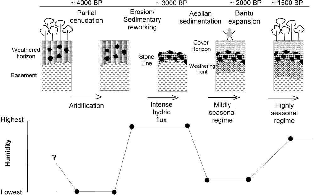
Schematic scenario summarizing the main stages of the geological evolution of western Central Africa since c. 4000 years and their possible connection with climate and environment.
Scénario schématique de l’évolution géologique de l’Ouest de l’Afrique centrale depuis c. 4000 ans et sa relation possible avec le climat et l’environnement.
5 Conclusion
The 14C data presented and compiled in this paper lead us to conclude that the profiles of surficial formations in Gabon were emplaced in a short interval of times, i.e. between c. 4000 BP and 3000 BP for the Stone Line and ≤ 3000 BP for the Cover Horizon. This interval is coincident with that reported for the last major environmental crisis in Central Africa. It is thus suggested that the environmental crisis and intense geological events which occurred between c. 4000–2000 BP were the consequence of the same dry climatic period responsible for an almost complete destruction of the equatorial rainforest. Such an environment provides an adequate frame for the intense aeolian sedimentation thought to have occurred at this time (Cover Horizon). Conversely, some aspects of the Stone Line remain enigmatic and especially the origin of the intense lateral forces which allowed coarse-grained materials of different origins to be mixed together in a very short period.
Acknowledgments
Geological mapping in Gabon was sponsored by E.U. (Sysmin funds) and the Gabonese Ministry of Mines. The BRGM Scientific Direction provided financial support for geochronological analyses. The team of the ‘Sysmin’ project is greatly acknowledged for the invaluable years we spent together in the Gabonese forest. Thanks to C. Castaing, D. Haccard, E. Egal, H. Théveniaut, A.M. Lézine for their support, C. Truffert for her help, B. Clist, J. Maley and R. Oslisly for informations on their own works and two anonymous reviewers for their comments and suggestions on a first version of this paper.