

1 Introduction
Coastal dunes are connected with sea level vicinity, and storminess, as a function of sedimentary supply (Einsele, 1993; Maüz et al., 2013; Orford et al., 2000). In that way, anthropic perturbations, such as agro-pastoral practices, may favour sand remobilisation on a regional scale (Pye and Tsoar, 2013). Most studies link the Aeolian coastal deposits to regressive phase (Maüz et al., 2013; Pye and Tsoar, 2013), and some to a rising SL (Pye and Tsoar, 2013; Regnauld et al., 1996; Szkornik et al., 2008). A link between historical dune building and periods of limited marine regression (ca. 50 cm) has been suggested (Lamb, 1995; Orford et al., 2000). Dune formation in a context of rising RSL results from the reworking or overstepping of the coastal foredune or storm ridge.
The history of the Holocene Relative Sea Level (RSL) on the northwestern European Shelf is a continuous rise followed by decelerating steps (Goslin, 2014; Shennan and Horton, 2002). An increased storminess is responsible for numerous episodes of sand drift and dune building along the western European coast, especially during the coolest part (AD 1570–1900) of the Little Ice Age (LIA, 1350–1880; Bärring and Fortuniak, 2009; Clarke and Rendell, 2009; Lamb, 1995). The degree of preservation of dunes is largely constrained by the speed of the RSL rise and the wave energy regime, expressed here in terms of storm activity (Pye and Tsoar, 2013). The availability of sediment for dune building is controlled by sediment accumulation in the nearshore environment (< 10 m deep; Einsele, 1993). Firstly, this requires low-energy waves that allow an accumulation of sand on the beach profile and permit its drift in the form of a foredune (Short and Hesp, 1982). Secondly, it requires prevailing onshore winds to blow this sand inland. The source of available sands can be variable and include the reworking by RSL rise of past periglacial deposits, saprolites, or old marine deposits with some importation to the shore by river (Kelley et al., 2005). Additionally, large shelves, such as the shallow English Channel and North Sea, are generally excellent sediment suppliers, compared to the narrow American platform surrounding the dune coastal ridges studied in the present paper.
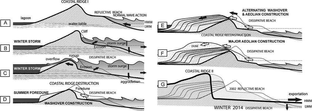
From a general point of view, in summer, dissipative beaches present a wide foreshore, a low gradient, and fine sands that are less resistant to wind flow, and are more conducive for Aeolian sand transport than the steeper reflective beaches (Hesp, 1999). Reflective beaches are much less favourable for Aeolian transport (Hesp, 1999). The dune building process mostly results from the impact of recurrent storm periods that lower the beach profile, especially at the HWM (Hallégouët, 1981; Ruz and Meur-Ferec, 2004). The beach profile becomes dissipative, as it was the case in Brittany in springs of 2010, 2013 and 2014: a thick foredune was formed in summer 2010 at Guisseny (Fig. 1a; Suanez et al., 2012) following a spring storm. Extreme storm events are responsible for erosion processes and over the course of a single extreme event, thick sediment deposition from the upper shoreface to the lower foreshore can occur (Fruergaard et al., 2013; Houser et al., 2008). They can also provoke erosive processes on the coast by offshore exportation of sand (Goff et al., 2004). This seems to be the case for western Brittany, after the long period of extreme waves in February 2014 (Fig. 2). Vegetation is also a major factor controlling the formation and morphology of coastal dunes (Hesp, 1999; Pye and Tsoar, 2013). Plant cover is responsible for roughness and reduction in the wind velocity, which increases the trapping of sands (Hesp et al., 2009). Climate and anthropogenic activities may thus influence dune formation.
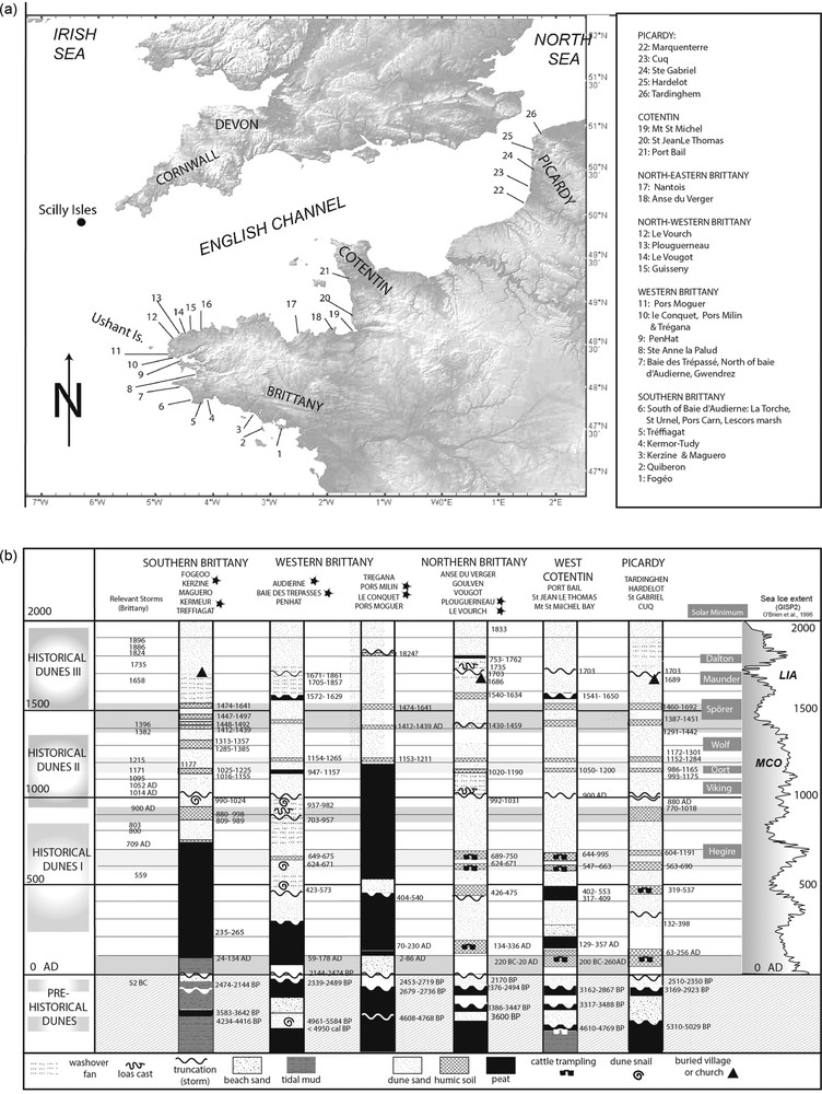
Location (a) and stratigraphy (b) of the dunes of Brittany, Normandy, and Picardy. For the data, see the text.
Sketch of the barrier evolution in a limited sand supply environment, with both rising sea level and storminess from 2400 BP to present.
Brittany is one of the most exposed coasts in France, characterized by a limited sand supply on a very flat polygenetic rocky platform, especially along the western and northern coasts. The coastal accumulations usually form ridges, topped with a thin dune, isolating partly (lagoon) or totally (marsh) depressions or valleys. Today, the RSL keeps rising (Cazenave and Remy, 2011) and coastal retreat occurred at a rate of about 1 m/year in the bay of Audierne (1966 to 1988; Faye et al., 2007). Extreme storms mostly develop when the North Atlantic Oscillation (NAO) mode is negative on the decennial scale, although the NAO can be interrupted by shorter positive events, especially during a high Atlantic Multidecadal Oscillation mode (AMO; Van Vliet-Lanoë et al., 2014b). Since 2007, the storms’ frequency rose, reactivating the coastal retreat, with no marked drift of sands. The aim of this paper is to synthetize the conditions, timing, and meaning of dune formation in Brittany.
2 Geological and geomorphological setting
From a geodynamical point of view, Brittany's peninsula is related to the post-rift subsidence of the Atlantic margin (Ziegler, 1992). The recent Holocene RSL curve established for Brittany (Goslin, 2014) indicates an estimated subsidence rate of ca. –0.3 mm/year for the last 2000 years. Reconstructed regional sea levels (RSL) show progressively a slow-down of the rise, with clear inflexion points around 7000 cal BP (calibrated years before present), 6000 cal BP, 4500 cal BP and around the 3–2000 cal BP period, without any distinct oscillation or stepwise character (Goslin, 2014). The tidal platform is mostly rocky, usually wide (one to several kilometres), and deepens very regularly to –30 m offshore. Regional tidal regimes are mostly macrotidal. The offshore sedimentary cover is thin and limited, dominated by rock outcrops. Generally, terrigenous sediment supply by rivers is limited. Southern Brittany, especially to the east, is an exception due to important rivers and old marine formations that provide a larger sand supply. Soil erosion is the main provider for coastal sands via the rivers (Fan et al., 2004; Guillén et al., 2006). Slash and burn practices produced a limited forest clearance from ca. 4000 cal BP (Early Bronze Age; Marguerie, 1992) exposing to interglacial rainfall a relictual periglacial topography (Van Vliet-Lanoë and Guillocheau, 1995). True agriculture developed regionally during the Iron Age, and the other main forest clearance epochs occurred in Merovingian times (6th–8th centuries) and between the 15th and 17th centuries. Damming of the rivers and estuaries developed from the11h century onwards, limiting sediment supply to the coast.
3 Methodology
This work is mostly based on coastal section surveys (Fig. 1a and b) completed by vibrocores and drilling transects at Audierne Bay, Kermor-Tudy (Bénodet Bay), Grand Loch de Guidel and Kerzine (Lorient), Le Conquet, Pors Milin (Brest), Le Vourch and Guisseny (Ploudalmézau). Stratigraphic descriptions with AMS-14C dates have been undertaken on these sections (Goslin, 2014; Van Vliet-Lanoë et al., 2014a) and completed in March 2014. The stratigraphical data of Meurisse-Fort (2009) were used for Normandy and Picardy. In this study, ten new AMS-14C dates (Poznan Radiocarbon Lab., Poland) have been obtained (Table 1), exclusively in connection with the dune building phase, with a calibration using CALIB 7.0. Software (Stuiver et al., 2005) and radiocarbon calibration (IntCal13; Reimer et al., 2013). Considering the regional scarcity in 14C datable material, we used all available information existing in the literature. In this paper, we discuss 81 pertinent age determinations of dunes and coastal ridges from Brittany, Normandy, and Picardy, directly compiled in Fig. 1b.
New dating from dunes bodies, Brittany. For location, see Fig. 1.
| Place | Dated material | Lab no. | Conventional age (BP) | Calibrated (BP) | Calibrated | |
| Historical dunes III | Porz Moguer | Buried peaty soil | Poz-25199 | 90 ± 30 | Modern | (AD 1808–1928) 1830?? |
| Pors Milin (Brest) | Buried peaty soil (stabilisation) | Poz-25198 | 335 ± 30 | 309–476 | AD 1474–1641 | |
| Vougot 2-1 | Diatom's mud at dune base | Poz-56621 | 440 ± 30 BP | 491–519 | AD 1431–1459 | |
| Kerzine 3-1 | Humic soil in dunes (stabilisation) | Poz-56620 | 390 ± 25 | 458–502 | AD 1448–1492 | |
| Conquet 1 | Stabilization (dunes on schorre) | Poz-48762 | 500± 35 | 511–538 | AD 1412–1439 | |
| Kerzine 3-2 | Peat below sand | Poz-56629 | 590 ± 30 | 593–637 | AD 1313–1357 | |
| Historical dunes II | Vougot 2-2 | Organic mud | Poz-56622 | 1010 ± 30 BP | 919–958 | AD 992–1031 |
| Historical dunes I | Vourch 2-2 | Dune base | Poz-56625 | 1240 ± 30 | 1200–1261 | AD 689–750 |
| Pre-historical dunes | Vougot 2-3 | Black peat below tidal mud | Poz-56623 | 2440 ± 35 | 2376–2494 | 545–427 BC |
| Vougot 2-4 | Peat (pre-dune) | Poz-56624 | 3195 ± 35 | 3386–3447 | BC 1498–1437 | |
| Kerzine 1-3 | Organic brackish mud (pre-dune) | Poz-56797 | 3880 ± 30 | 4234–4416 | BC 2467–2285 |
Palaeo-storm events were identified through sedimentary fabrics (Buynevich et al., 2004). Palaeo-storminess traces have already been discussed and events were extracted from the Holocene prism stratigraphy (Van Vliet-Lanoë et al., 2014b). The RSL curve for Brittany (Goslin, 2014; Goslin et al., 2013) was calibrated with the local tidal range, using a multi-proxy analysis based on the combined of geochemical, micromorphological, and isotopic indicators.
4 Sea level and storminess morphological impact
The effects of storms on Holocene sedimentary sequences are particularly important since the mid-Holocene period, when the regional RSL reached a position close to the modern one. The sedimentary record of RSL rise and particularly the High Stands (HS) were perturbed by the increased strength of storm surges, mostly after Roman times (Meurisse-Fort, 2009). Large-scale (pluri-decimetric to metric) pseudo-oscillations observed in SL reconstructions (e.g., Morzadec-Kerfroun, 1974) are the expression of disturbances of the sedimentary record induced by storms (Goslin et al., 2013; Van Vliet-Lanoë et al., 2014a). Extreme storms or several-day gales could be responsible for major morphological changes in the former ridge and back-ridge zones. From our observations, pseudo “HS” seem to be perched notches in sands or depositional terraces, situated at 1–10 m above the High Water Mark (HWM), mostly, which may form as a result of dispersive swash action (McKenna et al., 2012) and commonly forming in lagoon-perched washover fans. Low standing storm ridges result from run-up erosion of the crest, favouring breaching (Fig. 2). Storm-cut platforms develop in soft material down the ridge at the level of the average Low Water Mark (LWM; Retallack and Roering, 2012) It allows us to interpret “low surface” as an erosion surface formed as the result of sediment export by storm (Fig. 2). Recurrent severe storms may accentuate the erosion. After the storm, the restoration of the normal beach profile and of the coastal ridge by swell and wind may take some time, following the sediment supply of the beach.
5 Dunes building phases: data
Aeolian deposits are rarely resting directly on rock but commonly found on beach deposits, or resting on cultivated soils or peats. Stabilisation periods are often marked by humic soil or peat formation and these are often interrupted by thin Aeolian sand sheets, or, more rarely, by thin colluvial loamy deposits (in the vicinity of cliffs). Convolute deformations can be observed in several sites. In washover fans, they are often associated with load casts (Lindström, 1979), although in some places, they result from cattle. It is debated whether the swash or animal treading hurts oversaturated sands (Allen, 1982). Today, in Ireland, cattle commonly visit the dunes and shores. In Picardy, the coast was pastured by the marsh little ox (Meurisse-Fort, 2009). For the Merovingian dunes of northern Brittany, sheep and goats are probably responsible for the small-sized trampling deformations.
5.1 The pre-historical dunes 3050 à 2300 cal BP
The base of Penhat dune (Crozon, Fig. 1a,b) attests to the oldest sand drift (ca. 5280 cal BP; Meurisse-Fort, 2009). At Audierne (Gwendrez; Fig. 1a), the onset of dune accretion was later than 5000 cal BP (< 4950 cal BP; Haslett et al., 2000). In the Kermor marshes (Fig. 1a), a “brackish” sandy peat resting on a fresh water peat yields an age of ca. 5122 cal BP at +0.7 m NGF, perhaps attesting to the breach of coastal ridges by storms with limited Aeolian sand drift. At the Anse du Verger (NE Brittany), a date of 3600 cal BP was obtained for the onset of dune building (Regnauld et al., 1996).
After the construction of the first coastal ridge, peat began to accumulate in back-ridge depressions during the Halstatt period, as in the Bay of Audierne (ca. 2450 cal BP; Carter et al., 1993) and also at Santec on the northern coast of Brittany (ca. 2420 cal BP, Morzadec, 1974). The first well-recorded building of the dunes occurred between 2450–2350 cal BP at the Bay of Audierne (Van Vliet-Lanoë et al., 2014a). Here, a true storm ridge was topped with a dune dated to 2339–2487 cal BP (Van Vliet-Lanoë et al., 2014b) as also at the Anse du Verger (NE Brittany) ca. 2170 cal BP (Regnauld et al., 1996).
5.2 The historical dunes
5.2.1 First generation, 350 AD–800 AD
Sand dunes invaded the Saint-Urnel cemetery (Bay of Audierne) in late Roman times (3rd century; Giot and Monnier, 1977) (Fig. 2). Breaching of the coastal ridge and flooding reappear locally at Bay of Audierne (Lescor's marsh and Troenoen lagoon) after 320 AD, in association with Aeolian drift. A brief stabilization is recorded here between 620 and 680 AD, as also in southwestern and northern Brittany (Table 1, Fig. 1b).
5.2.2 Second generation, 800 AD–1200 AD
A second dune invasion was well documented between ca. 800 AD and ca. 1000 AD at Saint-Urnel (Giot and Monnier, 1977), mainly during the second half of the 11th century. This burial place was re-abandoned in the late 12th century (Giot and Monnier, 1977) with a renewed dune invasion. This period was marked by giant storms, well recorded around 900 AD in southern Brittany (Van Vliet-Lanoë et al., 2014b). A limited stabilisation was observed from 1000 to 1200 AD, which was recorded in the form of humic soils or peaty layers in the region, although it was frequently interrupted by giant storms in the form of washover fans during the 11th century (Van Vliet-Lanoë et al., 2014b). Around Brittany, the ridges were often truncated and/or buried by sand drift or splay (Table 1; Fogéo: Visset and Bernard, 2006; Treffiagat, la Torche and Pors Milin: Van Vliet-Lanoë et al., 2014a; Baie des Trépassés: Carter et al., 1993; Plouguerneau, Morzadec-Kerfourn, 1974).
5.2.3 Third generation, from 1350 AD
From ca. 1350 AD to ca. 1500 AD, a first period of sand drift was recorded, ending with brief stabilisations marked by humic soils from ca. 1400 to ca. 1550 AD (see Fig. 1a), which were better developed than during the MCO.
In the Bay of Goulven, Guisseny and Plouguerneau (Fig. 1a), dunes continued to migrate during the 17–18th centuries. Such dune migration also occurred at Audierne and other places, particularly in southeastern Brittany (Guilcher and Hallégouët, 1991) and in Normandy and Picardy (Meurisse-Fort, 2009). Several churches and villages in these regions, as well as in Brittany and Picardy, were buried by sands in the late 17th century in association with major gales. After a period of relative quiescence, storms and sand drift again destroyed church and villages in the region, with sand drifts up to 5 km inland. Major storm events occurred in 1795, 1808 and 1824.
6 Discussion
6.1 Stratigraphy
The onset of sand drift leading to the development of Pre-historical dunes in Brittany occurred very locally after 5000 cal BP. Sand drift with dune building appeared closer to 2750 cal BP, as a result of enhanced storminess driven by a major cooling event associated with the Homeric solar low (Van Vliet-Lanoë et al., 2014b). Since ca. 2750 cal BP, dunes developed in Brittany, as on most of the European coasts (Meurisse-Fort, 2009; Wilson et al., 2004). In the Bay of Audierne, a second phase of sand drift seems to develop after the onset of the La Tène Iron Age (ca. 2425 cal BP), reworking the former deposits and splaying the sand locally inland (Giot and Monnier, 1977). This occurred in response to a brief climate degradation that corresponded to the Greek solar low (centred at 2300 cal BP).
The onset of dune building occurred in a similar time span after 4000 cal BP in Picardy (Meurisse-Fort, 2009), Aquitaine (Clarke and Rendell, 2009), Northumberland (Orford et al., 2000) and Denmark (Clemmensen et al., 2009), after 3500 cal BP in Belgium (Anthony et al., 2010) and the Netherlands (Jelgersma and Van Regteren Altena, 1969). We may consider the onset of dune building to be clearly connected with the slowing down in the SL rise from ca. 4500 cal BP (e.g. Goslin, 2014). From that time, the HWM reached the present-day LWM, allowing an easier accumulation of sediment in the upper beaches. It indicated the onset of the Holocene high stand. The sediment supply lowered mechanically due to slower SL rise and more limited coastal erosion, mostly driven by storm activity, especially during cold events (Van Vliet-Lanoë et al., 2014b), but temporarily rose by soil erosion resulting from Bronze Age forest clearance.
Historical dunes tell another story: the dunes are preserved at the northern and western coast at the Roman times, but do not yet exist as coastal ridge in the south. A first splay of sands from 350 to 600 and from 700 to 800 AD is recorded in Brittany. The onset of the historical dunes I is well developed at a wider regional scale, in southwestern Cotentin (Fig. 1; Meurisse-Fort, 2009) or in the Scillies’ Islands (250–330 AD; Barnerjee et al., 2001). Some storms were recorded around 540–600 AD and 680–720 AD in Brittany (Van Vliet-Lanoë et al., 2014b), separated by a brief stabilization (640–760 AD; Patterson et al., 2010), which was well recorded in the entire region (Fig. 1b). The start of these Merovingian dunes seems rather synchronic at the scale of western Europe (Fig. 1b), related with cold and stormy weather from 200 AD (McCormick et al., 2012; Patterson et al., 2010). Sand drift was recorded from ca. 260–300 AD, probably when the morphology of the beaches had been sufficiently lowered to become dissipative and the sensible vegetation had been destroyed by agro-pastoral activities developed by Merovingian times (Fig. 1b). A major point is the occurrence of frequent cattle trampling that coincided with the development of forest clearance and agro-pastoralism in Brittany, Cotentin and Picardy, which promoted instabilities in the sand cover: these destabilised dunes thus drifted further inland, with the largest splay of the whole dune generation. Villages were found in nearshore positions during the 7th century. It seems possible that, from that time, the sedimentary budget seriously lowered, partly due to regional anthropogenic practices and mostly inland sand drift. The climate also cooled from 536–540 AD in response to a volcanic eruption (Gao et al., 2008) and to a first solar minimum between 615 and 755 AD (Usoskin et al., 2007), fitting the Hegira period (Fig. 1b). The cooling from ca. 700 to 800 AD is related to a second solar low, the Viking minimum. Here, dunes continue to grow transversely, attesting to a progressive aggradation and regular westerly winds only. The record in storminess attests to recurrent storms events, but no giant one. This generation of sand drift is not clear in southern Brittany, where the coastal budget and wind directions are normally more favourable, and the coastal ridge seems still vegetated. The Quiberon peninsula was still covered by forest in the 11th century.
The onset of the historical dunes II (Brittany: 800–1250 AD) occurred synchronously all over Europe (Jelgersma et al., 1995; Meurisse-Fort, 2009). The period from 950 to 1350 AD is often considered to be the European Medieval mild period (Hughes and Diaz, 1994). Rainy conditions existed all over Europe (Marusek, 2010), promoting sand supply by rivers. Villages migrated inland as well in Brittany, Picardy, and the Netherlands (construction during the 7th century); this migration was also connected with the Viking invasions. Centennial hurricanes were recorded in Brittany, in the southern British Isles and also along the coast of western Cotentin (Fig. 1a; Van Vliet-Lanoë et al., 2014b). Hurricanes are recorded in northern France (890 AD, Meurisse-Fort, 2009), in Belgium, with the formation of the Zwin in 1134 AD, and in the Netherlands, easing the formation of the Zuiderzee (large storms in 838 AD, 1170 AD and 1240 AD, Buisman, 1965). These events were connected with the Oort solar minimum (1010–1050 AD; Usoskin et al., 2007). A very negative NAO, which was even recorded on Greenland (Kobashi et al., 2013), was responsible for very high sea surface temperatures in the NW Atlantic, which resulted from a warm intertropical ocean, a positive AMO (Van Vliet-Lanoë et al., 2014b). Here, the inland sand drift inland was more limited, due to heavy precipitation, filling mostly lagoons. Storm ridges, which were eroded to their back (Fig. 2), are found along the current coastline. The morphological transformation was a major one along the whole coasts of Brittany. In Picardy, the shift from transverse dunes to parabolic ones is explained by a reduction in sand supply from the beach, a more extensive vegetation cover (high water-table) and potentially harsher winds (Meurisse-Fort, 2009). A quiet period for sand drift seemed to exist from 1250 to 1340 AD (Fig. 1b) (Van Vliet-Lanoë et al., 2014b), which corresponds mostly to the Medieval Climate Optimum (MCO). The climate during this period was mild and the NAO mostly positive (Trouet et al., 2009), which resulted from a rise of the AMO in response to strong solar activity (1100–1250 AD; Usoskin et al., 2007).
The onset of the historical dunes III (Brittany: 1350 AD to present) coincides with the onset of the LIA in Europe; it shows the initiation and build-up of the recent dunes (1350–1750 AD), with a development, maximized during the LIA. Most of the LIA was dominated by giant storms and an unstable negative decennial NAO (Trouet et al., 2009), despite few positive AMO events. High frequencies of SW winds were recorded in Britain (London) from 1340 to 1420 and from 1470 to 1550 AD (Lamb and Frydendahl, 2005), corresponding to mild weather with regular, W’ly gales, attesting to the prevailing positive winter NAO and fair weather optimal for building real dunes. A first period of dune building occurred from 1350 to 1550 AD (Fig. 1b), a period of relative storm quiescence, especially from 1350–1530 AD in the northern and central Atlantic (prevailing positive decennial NAO with low AMO modes), which corresponded to peculiar weather (Van Vliet-Lanoë et al., 2014b) and AMOC patterns (Trouet et al., 2012). A first stormy period of the LIA occurred from ca. 1460 to ca. 1630, which was responsible for more important dune activity, which corresponded to the Spörer solar minimum (1460–1550 AD) and a prevailing negative winter NAO. From 1600 AD, Sea surface temperatures north of Iceland dropped (Bendle and Rosell-Mele, 2007), attesting to a low AMO mode. The prevailing winter NAO mode was negative and boosted by the Maunder Minimum (1645–1715 AD; Trouet et al., 2009; Usoskin et al., 2007). In the Scillies, an important sand drift has been dated AD 1560–1680 (Barnerjee et al., 2001). This is the second period for giant storms, this time with a meridian wind pattern (Van Vliet-Lanoë et al., 2014b) driven by unstable jet streams and brief positive NAO anomalies. Sand drift was major, burying churches and villages along the English Channel. The long Great Storm of 4–8 December 1703 crossed the English Channel and Brittany (Lamb and Frydendahl, 2005). Similarly, the Christmas 1717 four-day storm affected most of Europe north of the Gulf of Biscay, while the 19–20 January 1735 and 16 February 1736 events affected Brittany, Cotentin, and the Scillies, (OSL dating: 1700–1780, Barnerjee et al., 2001). Superimposed storm surge layers (Lindström, 1979) exposed on the Keremma spit (Bay of Goulven) have been dated with OSL to 1752–1776 and 1723–1751 AD (van Heteren, 2011), and attest to a major sand offshore exportation in 1703 AD (no dune field), which destroyed the former spit.
A third sand drift event can only be dated with archives and old maps. It took place mostly at the end of the 18th/early 19th centuries, in relation to the Dalton Minimum (1790–1820). Again churches were buried on Batz Island (northern Brittany) and Skagen (Jutland). Mains storm events occurred regionally in 1795, 1808, and 1824 AD, with dominant W’ly winds. Dunes developed longitudinally at Sainte-Anne-la-Palud and at Kerzine (Fig. 1a). In between these events, high frequencies of SW winds were recorded in Britain (London) from ca. 1730, ca. 1860 and 1900–1930 (Lamb and Frydendahl, 2005), signalling positive NAO periods fitting the relative landscape stabilizations.
6.2 Dynamical context: dune disappearance in the near future
When the stormy period ends, the beach is rapidly supplied with sands migrating gently from the subtidal accumulation (Fig. 2). The erosion notch is rapidly buried by dune collapse during the after-storm restoration of the beach. Additionally, when the climate warms up, water seepage further eases the fixation of drift sand. Firstly, a foredune is formed mostly in spring. Then, from late spring to late summer (water-table lowering), drift sand is mobilized, climbing on the foredune and beginning the construction of the true dune. When the autumn's equinoctial storms occur, important drift may occur but also wave run-up may initiate interstratified dune/washover facies, as observed at Audierne, Guisseny, and Goulven (Fig. 2). When this succession of events occurs within the same year, vegetation growth cannot impede the process.
Wind direction also has an important impact on dune formation. During positive NAO modes, regional winds are mostly Westerlies (Pirazolli et al., 2004). During negative NAO modes, the prevailing winds are meridian (Hénaff, 2008), driven by the important oscillations of the jet stream. This is the main reason for some regional differences in dune formation, as related to the coastal orientation.
When a period of low storm activity occurs for several years with a positive NAO and a high AMO mode, vegetation recolonization occurs rapidly after the storm due to wetter, but not necessarily warmer conditions, leading to a more stable coastline. In this case, ecological perturbation by tourism or by free pasture destabilizes the dune field, even if storminess is not particularly high. This is very clear the post-1945 mobility of the dunes at the Bay of Audierne, which were also strongly perturbed by sand exploitation and tourism (Hallégouët, 1981). For the 17th century, free pasture, vegetation clearance for agriculture on sand, and seaweed yield strongly perturbed the dunes in Brittany; this occurred in combination with reclamation of the upper tidal marsh areas in back-ridge positions. This situation was accentuated since the Second World War by quarrying of the dune, and onshore and offshore sands exploitation, leading to a very negative budget (Guilcher and Hallégouët, 1991).
Dunes have recycled the same stock of sediment, which was already limited in Brittany for geological reasons, with the slowing down since 3000 years of the transgression, although this has been somewhat re-accelerated by the recent warming. The dissipative status of beaches underlying dune ridges, as in the Bays of Audierne, of Goulven and at Guisseny, signals a continuing long-shore depletion of ridge sediment by erosion (Short and Hesp, 1982). Inland sand drift was important during the historical dune formations, but seems limited to local inland recycling since the LIA (dry storms). Giant LIA storms have resulted in the second major retreat of the coastline, despite some supply of sediments by forest clearance in Merovingian times. Damming rivers for water or tide mills activities limited the sand supply in western Brittany from the 11th century onwards. LIA dunes are less calcareous at the Bay of Audierne or are richer in organics, as in Picardy, attesting to the reworking of the stabilized bodies. The existence of “dead” dunes perched on cliffs (Fig. 1a) also attests to a depleted sedimentary stock. A less negative budget along the coast of southern Brittany explains the latter preservation of coastal dunes (mostly formed after the 11th century), which are now endangered by both onshore (dune quarrying) and offshore sand exploitation.
As very important storms are associated with tall waves, up to 15 m high on the platform, sands are not only exported to the shallow nearshore (< 10 m of depth), but are also reworked to a depth exceeding – 30 m, leading to progressive sediment exportation by shelf currents to the platform edge (Fan et al., 2004; Goff et al., 2004; Guillén et al., 2006), a process particularly efficient with dry storm (Guillén et al., 2006). This suggests that there is, in many places and especially in Brittany, no large sediment volume available on the beach for a future period of dune building, as was already stressed for UK by Orford et al. (2000).
6.3 Global climate control
During cold events on Europe, typically associated with negative NAO modes and solar lows, precipitation is usually reduced (Hurrell, 1995), whilst Aeolian aggradation may result from moderate but frequent gales, thereby favouring the development of coastal dunes without or on former storm ridges. The extent of sea ice explains a more accentuated cooling of the western Atlantic Ocean, as occurred during the LIA (Miller et al., 2012) in association with a negative, decennial NAO mode (Trouet et al., 2009). Moreover, a sea ice-triggered cooling is consistent with a limited regression of a thermosteric nature (≤ 0.5 m; Lamb, 1995). More frequent solar minima from Roman times (Usoskin et al., 2007) resulted in a more frequent negative NAO mode, sea ice extent and storminess. Additionally, dunes are strongly influenced by anthropic practices that artificially favour dune mobility, especially from the late Roman times. These practices induce sediment-supplying soil erosion with a rhexistasy dynamic of the coastal zone. We may thus suspect that within a context of rising SL, the occurrence of dunes is a man-made temporary and endangered anomaly of the Late Holocene HS. This conclusion is similar but more obvious than in a high sand supply environment as in Denmark (Clemmensen et al., 2009).
7 Conclusions
Dune development in Brittany only occurred during the latter part of the Holocene stratigraphic record as a result of abnormal sand supply. Even though dunes appeared sporadically at ca. 4000 cal BP (although not earlier), the first real dune occurrences, as were recorded by drilling, occurred from 3–2750 cal BP, in close connection with the slowing down of the Holocene transgression mostly from 3000 cal BP and agriculture development. As a result, dune fields were limited along most Brittany coasts, and later in southern Brittany where the sand supply was higher. The favourable building conditions for dunes are recurrent gales associated with dominant negative NAO mode. Most parts of the so-called dune ridges are storm ridges along the southern coast of Brittany that are only topped by dunes, and formed mostly from 900–1200 AD and during later periods of major storms driven by brief positive NAO event in a decennial NAO negative mode. Along the northern coast, dunes have a similar timing as in Picardy and Normandy, although erosion by major storms at the transition between the 16th and 17th centuries was responsible for the main storm ridge at the present coastline. Prior to the 20th century, dunes were represented regionally by thin sheets of sands, burying coastal relief and reworking mostly the top and the back of the coastal ridge. Many local dune fields have already disappeared. We think that within a context of rising SL, the occurrence of dunes is a man-made temporary anomaly of the Late Holocene, soon to be erased by both naturally and man-driven sediment starvation. This will result in the progressive disappearance of dunes with, consequently, higher risks for coastal submersion at these locales.
Acknowledgments
This work was funded by the French Research Program (ANR) COCORISCO (2010-CEPL-001-01). We also thank Barbara Maüz for judicious improvements in language expression of our ideas. We thank also Christophe Morhange for its constructive comments.