

1 Introduction
The Variscan belt is a broad complex mountain system that extends over more than 8000 km from the Caucasus to the Appalachian and Ouachita mountains due to the convergence between Gondwana and Laurussia (i.e. Laurentia, Baltica, Avalonia and Armorica) during Carboniferous times (Matte, 2001; Stampfli et al., 2002). The Variscan orogeny is characterized by a polyphase tectonics that resulted in the formation of the supercontinent Pangaea and left a relict Palaeotethys to the east (McCann et al., 2006). The collapse of the thickened Variscan orogenic crust ended in late orogenic crustal extension followed by a period of crustal instability and re-equilibration throughout western and central Europe (Ménard and Molnar, 1988). During Stephanian–Permian times, transtensional activity led to the formation of more than 70 rift basins simultaneously with a widespread magmatic event involving the extrusion of thick volcanic successions (McCann et al., 2006).
The Pyrenean Axial Zone is a fragment of the European Variscan belt reworked and incorporated into the inner part of the Pyrenees from Cretaceous to Miocene times, during the Alpine Orogeny (Mattauer, 1968; Matte, 1991). The Axial Zone shows a complex Variscan tectonothermal evolution resulting from an overall compressional tectonics dominated by dextral transpression (e.g., Carreras and Druguet, 2014; Gleizes et al., 1998). The fading of this compressional stress field promoted the onset of a new stage of extensional tectonics leading to the development of many Stephanian–Permian basins that are mainly scattered along the southern border of the Axial Zone, with a trend parallel to the east–west elongation of the belt (Fig. 1A and B). According to Bixel and Lucas (1983), these basins are the expression of local extension related to pull-apart structures and were filled with continental sediments and coeval volcanic and shallow intrusive rocks.

(A) Geological map of the Pyrenean Axial Zone showing the location of the main Stephanian–Permian basins. Redrawn from Barnolas and Chiron (1996). (B) Geological map of the Anayet Basin in the Pyrenean Axial Zone (modified from Rodríguez-Méndez et al., 2014). The dashed red line (see the Pdf version) marks the thermal metamorphic aureole of the Western Cauterets pluton. The location of the cross-section of Fig. 3B is indicated in the western part of the Anayet Basin.
The aim of this study is to constrain the pull-apart evolution of the Anayet Basin during the post-Variscan evolution of the central part of the Pyrenees (Fig. 1A and B). The Anayet Basin constitutes an excellent study area as it records a complete sedimentary sequence from Stephanian to Upper Permian times (Fig. 2) and is one of the places in the Pyrenees where the Upper Permian volcanic rocks are well exposed (Figs. 3A and 4A, Lago et al., 2004), some of them with accurate emplacement ages. Moreover, it is located over Variscan deformed rocks intruded by Late Variscan plutons, which helps to constrain the tectonic evolution of the magmatism in the central part of the Pyrenees.
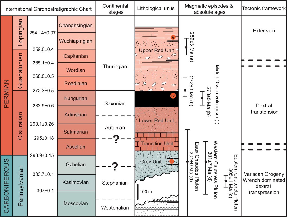
Correlation between the International Chronostratigraphic Chart (Cohen et al., 2013 (updated)), the continental stages and the proposed ages for the sedimentary filling of the Anayet Basin (Bixel et al., 1985; Lago et al., 2004; Ríos et al., 1987; Ternet et al., 2004). The three magmatic episodes interbedded within the Anayet sedimentary succession (I, IV, V) are represented in their stratigraphic position. The available radiometric ages for the granite intrusions and magmatic episodes are placed regarding their position in the international stratigraphic chart and not in the stratigraphic column: (a) Rodríguez-Méndez et al. (2014), (b) Briqueu and Innocent (1993), (c) Denèle et al. (2014), (d) Ternet et al. (2004). The Variscan tectonic framework is based on Carreras and Druguet (2014).
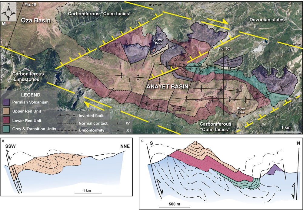
(A) Geological map of the Anayet Basin showing the location of the margin and the intrabasinal faults of the pull-apart system. The Grey and Transition units are represented together. (B) Cross section along the western termination of the Anayet Basin showing the Alpine positive inversion structure (See Figs. 1B and 3A for the location). (C) Cross section in the eastern part of the basin showing the main structural features (See Fig. 3A for the location).
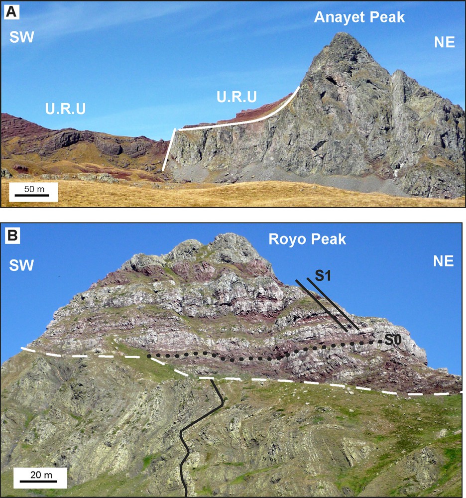
(A) Anayet magmatic episode partially covered by the Upper Red Unit (U.R.U). (B) Lower Red Unit rocks unconformable covering carboniferous “Culm facies” rocks in the eastern part of the basin.
2 Background geology
The Anayet Stephanian–Permian basin is located in the southern border of the Pyrenean Axial Zone. This basin is connected towards the west with the Oza Basin, and both together constitute the so-called Aragon–Bearn basin (Fig. 1A). The Anayet Basin extends over 12 km in a NW–SE direction between the Tena and Aragon valleys (Fig. 3A; 0°23′23″ W; 0°29′45″ W), reaching a maximum width of 3 km. In the study area, a low-grade metasedimentary sequence of limestones, sandstones and slates of Devonian to Carboniferous age composes the Axial Zone (Figs. 1B, 3A and 4B). The most representative Variscan structures consist of kilometric-scale, west-vergent recumbent folds with axial-plane cleavage, oriented mainly N340° E in its current position (Rodríguez-Méndez et al., 2013). Nevertheless, there is a great dispersion in the fold and cleavage trending due to the overprinting of south-vergent Alpine folds. Fold interference patterns due to the superimposition of Alpine and Variscan Orogenies are also recognized. The Cauterets–Panticosa batholith and the Eaux-Chaudes pluton crop out to the east and to the northeast of the Anayet Basin, respectively (Fig. 1A). These plutons record a late tectonic emplacement during the Variscan orogeny (Fig. 2): 301 ± 7 Ma U–Pb SHRIMP age for the Western Cauterets pluton (Ternet et al., 2004), 305.8 ± 1.2 Ma U–Pb LA–ICP–MS age for the eastern Cauterets pluton (Denèle et al., 2014) and 301.2 ± 8.7 Ma for the Eaux-Chaudes pluton (Ternet et al., 2004).
During Stephanian–Permian times, calc-alkaline to alkaline volcanic rocks were emplaced coeval with the opening of intracontinental basins in the Pyrenees. Five volcanic events are recognized in the Pyrenees (Bixel, 1987), but only three of them are represented in the Anayet Basin (Episodes I, IV and V, Fig. 2; Bixel and Lucas, 1983; Ternet et al., 2004).
3 Sedimentary record
The sedimentary record of the Anayet Basin has been considerably studied (Clin et al., 1970; Mirouse, 1959; Ríos et al., 1987; Ternet et al., 2004; Valero Garcés, 1994; Valero Garcés and Gisbert Aguilar, 1992). The predominance of breccias, conglomerates and red sandstones supports a continental, locally derived, origin of the sediments (Bixel and Lucas, 1983). The age of the formations remains imprecise, mainly because of the frequent lack of fossils with biostratigraphic utility in detrital deposits and the scarcity of absolute age data for the Permian rocks of the Pyrenees. All these, together with the diachronic nature of the sedimentary deposits in continental environments render difficult the correlation with other Permian basins and even the correlation of the different units within the basin. In southwestern Europe, the continental subdivision for the Permian deposits is commonly used, but the lack of absolute age constraints hampers its accurate correlation with the updated international chronostratigraphic chart (Cohen et al., 2013). Because of that, the correlation between some of the stages (i.e. Stephanian) is a pending issue, for which several solutions have been proposed (e.g., Montañez and Poulsen, 2013; Wagner and Álvarez-Vázquez, 2010). Based on the works of Haq and Van Eysinga (1988) and Falconnet (2014), we propose an alternative solution that integrates the available absolute ages and the main lithological groups of the Anayet Basin (Fig. 2).
Due to the great facies variability during Stephanian–Permian times and to avoid an excessive subdivision, we distinguished four main lithological groups, following the depositional units defined by Gisbert (1984) in the Pyrenees, which can be correlated all along the Axial Zone, and three volcanic episodes interbedded (Figs. 2 and 3A):
- • the Grey Unit (50–120 m, Fig. 5A) is a volcano-sedimentary complex, with a diachronic base and a lateritic roof that is formed by volcanic flows (Episode I) interlayered in shales, coal and brecciated conglomerates. The base of this unit is composed by plant-bearing limestones of Upper Stephanian to Autunian age (Bixel et al., 1985; Ríos et al., 1987) that constitute the oldest post-Variscan sedimentological record in the area. The Grey Unit includes the Campo de Troya and Punta de la Garganta formations (Clin et al., 1970). The first volcanic episode is better developed in the Midi d’Ossau area, 6 km to the north of the study area (Fig. 1A), where it consists of peraluminous ignimbrites of rhyolitic to dacitic composition at the base, and calc-alkaline basalts, andesites and dacites above. U–Pb ages of 278 ± 5 Ma and 272 ± 3 Ma have been reported for the basal peraluminous rhyolites and for the overlying dacites, respectively (Fig. 2, Briqueu and Innocent, 1993);
- • the Transition Unit is composed by alternating layers of shale, sandstone and oolitic limestone of grey colours, with a maximum thickness of 50 m towards the eastern end of the basin. This unit includes the base of the Somport formation (Mirouse, 1959) and the transition from Campo de Troya to Somport formations (Clin et al., 1970). The boundary between the Autunian and the Stephanian has been placed within this formation (Ríos et al., 1987);
- • the Lower Red Unit consists of 250-m-thick well-stratified red sandstones, occasionally conglomerates (Fig. 5B), with cross bedding (Fig. 5C) that corresponds to the Somport formation (Clin et al., 1970; Mirouse, 1959). The Anayet magmatic episode (IV, Fig. 4A) is found in the upper part of the Lower Red Unit. It includes lava flows (Fig. 5D), dykes and laccoliths of andesitic composition (Ternet et al., 2004), with the largest volume of these rocks concentrated along the northern and northeastern border of the basin (Fig. 1B). There is not absolute age data available for the Anayet volcanic episode, although Saxonian to Thuringian ages are postulated from the stratigraphic data of the country rocks (Lago et al., 2004; Ternet et al., 2004);
- • the Upper Red Unit is made up by three megasequences of red conglomerates, sandstones and minor shales that progressively thin upwards. In many cases, red shales with grey to yellowish calcareous nodules crop out. This unit includes the Baralet and Mercantón formations (Mirouse, 1959). The last magmatic episode (V) is emplaced within the Upper Red Unit and consists of alkaline basalts.
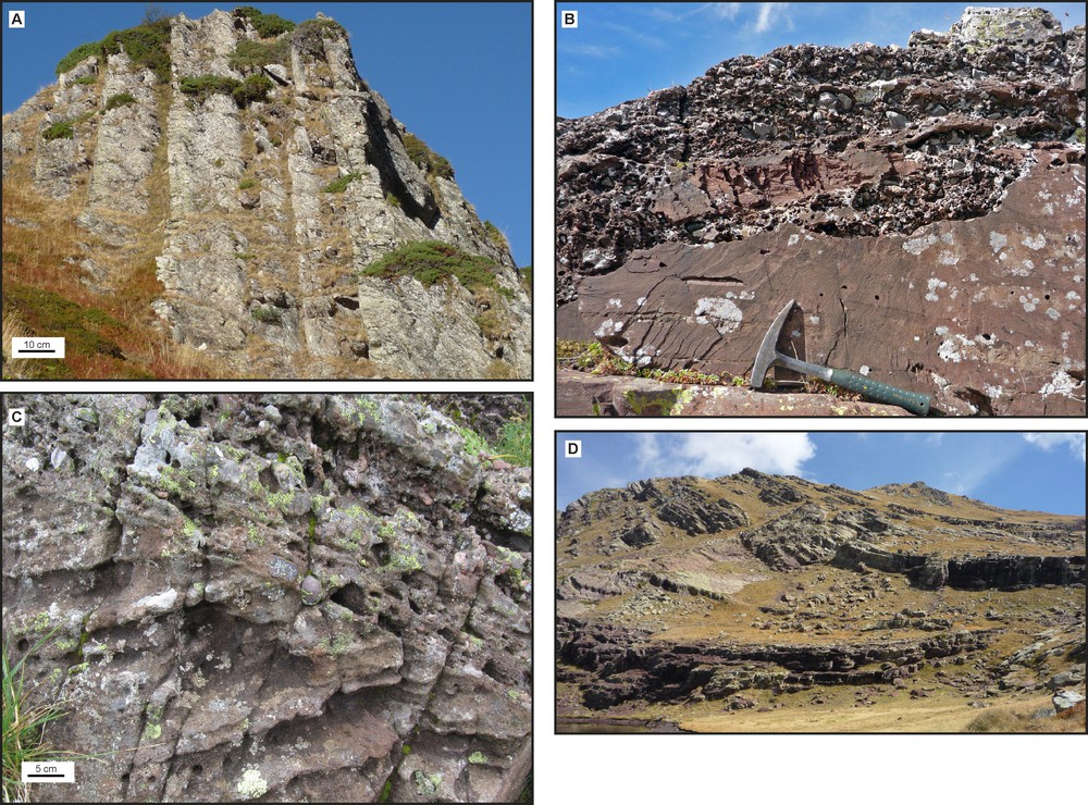
(A) Conglomerates of the Grey Unit. (B) Transition from sandstones to conglomerates (Lower Red Unit). (C) Cross bedding in the Lower Red Unit. (D) Low dipping limb of an angular fold in the Lower Red Unit with interlayered sills.
Moreover, dykes and sills linked to the Permian volcanism crop out in the Palaeozoic basement of the Anayet Basin (Fig. 1B). A 259.2 ± 3.2 Ma U–Pb SHRIMP age has been reported for a diabase dyke linked to the last magmatic episode (V, Fig. 2, Rodríguez-Méndez et al., 2014).
4 Structural features
A detailed cartography of the Anayet Basin shows increasingly younger rocks towards the west of the basin (Fig. 3A). Whereas the Upper Red Unit spreads continuously from the eastern corner of the Anayet Basin to the adjacent Oza Basin to the west, the remaining formations are restricted to the Anayet Basin. The Lower Red Unit shows a marked thickness reduction in the western side of its southern branch, in such a way that this formation finally disappears sandwiched between the overlapping Upper Red Unit and the underlying Carboniferous basement close to the neck between the Anayet and the Oza basins (Fig. 3A). It is worth noting that the cut-off point is along the southwestern prolongation of the NE–SW fault that marks the western termination of the northern branch of the Lower Red Unit (Fig. 3A). Finally, the Grey and Transition units, which are confined to the eastern half of the Anayet Basin, should have the geometry of a wedge narrowing southwards as they do not reach the southern branch of the basin (Fig. 3A). The alignment and concentration of the volcanic rocks interlayered with the Permian sediments along the northern border of the Anayet Basin suggest that the ascent of the magma took place through the WNW–ESE fractures that mark the northern basin margin. Previous maps of the region represent the southern contact of the Anayet Basin as a detachment fault with a top-to-the-south motion (Ríos et al., 1987). However, field observations show that the western part of such contact is a fault that dips steeply, ∼60°, to the northeast. Although the fault juxtaposes younger (the Permian Upper Red Unit) over older rocks (the Carboniferous limestones, Fig. 3), the asymmetry of the S–C tectonites that mark off the fault reflects a reverse, top-to-the-south, shear sense (Fig. 3B). Such structural features are consistent with a process of inversion tectonics; the fault evolved as the southern normal border of the Anayet Basin in Permian times and was reactivated as a reverse fault during the Alpine compression (Rodríguez-Méndez et al., 2014). To the west of the Aragón River (Fig. 1B), the border fault runs through Carboniferous materials due to the deep carving produced by erosion of ancient glaciers. From the Aragón River to the east, the contact between Carboniferous and Permian rocks is a gently folded unconformity with a mean dip of only 20° NNE (Fig. 4B). The topographic deepening of the unconformity increases westward, about 850 m in 12 km along the axis of the basin. The deepening of the unconformity is affected by sudden changes that probably reflect the existence of local depocenters and paleohighs with a transverse NE–SW arrangement.
South vergent chevron folds deform the Stephanian–Permian rocks of the Anayet Basin. They exhibit long limbs dipping 20–30° to the north and vertical to reversed short limbs (Fig. 6A and B). Fold axes are subhorizontal and display trends scattered from N90° E to N120° E. The axial traces of the major folds are represented in the maps (Figs. 1B and 3A). These folds have an average wavelength of 400 m, show many minor folds (Fig. 3A) and a widespread axial planar cleavage (S1) that dips 40° to 60° N. The dip variation is mainly due to refraction processes because of the competence contrast between the materials (Fig. 6C). Under the microscope, the cleavage is characterized by the preferred orientation of quartz and opaque minerals and reinforced by pressure solution processes (Fig. 6D). The overall structure of the Anayet Basin is summarized in a NNE–SSW cross-section, which is perpendicular to the fold axes and extends from the northern to the southern border of the basin (Fig. 3C). Two structural features deserve attention: (1) There are three major folds, two large anticlines and a syncline in between, and (2) all the folds in the region display the same southward vergence. The location of the anticlines along the current northern and southern edges of the basin is consistent with the activation of buttressing effects against the border-normal faults of the basin during the Pyrenean compression. Consequently, the two main anticlines help to constrain the approximate location of the largely eroded border-normal faults of the basin (Fig. 3C). The attitude of the axial surface in folds associated with the border faults of tectonically inverted basins frequently mimic the dip sense of the faults (Williams et al., 1989). The extrapolation of this common fact to the northern anticline of the Anayet Basin would imply that the corresponding border-fault is subvertical or steeply dipping to the north (Fig. 3C).
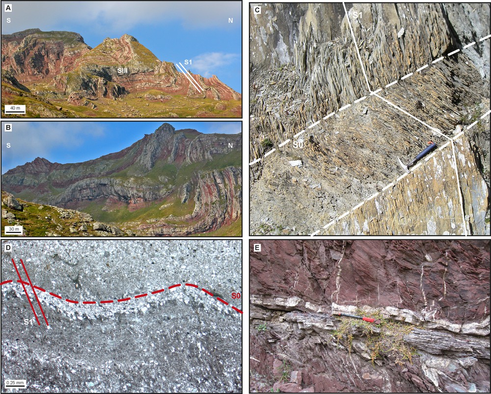
(A) Chevron folds with axial plane cleavage deforming the Upper Red Unit and a sill. (B) South vergent chevron folds with axial plane cleavage in the eastern part of the basin. (C) Refraction of the axial plane cleavage due to competence differences in the Transition Unit. (D) Photomicrograph showing the cleavage in a sandstone. (E) Fault plane with calcite veins in a sandstone of the Upper Red Unit.
No main thrusts are detected in the Permian rocks; however, small-scale décollements, usually at a low angle or parallel to the beds, are identified along the gently dipping limbs of the folds (Fig. 6E). These minor décollements are highlighted by the concentration of white calcite veins in the red-coloured rocks. Moreover, three main systems of late normal faults are present, with N10° E, N50° E and N330° E strikes (Fig. 3A).
5 Discussion
The Permian sedimentary and volcanic deposits of the Anayet region, in the central part of the Pyrenees, experienced a process of inversion tectonics during the Alpine compression. However, structural and stratigraphic data enable a pull-apart setting to be identified for the basin opening. Three main fault systems are recognized in the Anayet Basin: N10° E, N50° E and WNW–ESE (Fig. 3A). Although the N10° E faults are the best developed, they do not fit in a dextral transtensional evolution model. In the Middle–Upper Permian, an evolution from dextral to sinistral transtension was proposed in order to explain the NNE fault orientation pattern (Bixel and Lucas, 1983, 1987). We discard the relation of the N10° E fault system with the formation of the Anayet Basin because they are also present 3 km to the south, in the Upper Cretaceous to Eocene rocks of the South Pyrenean Zone (Fig. 1B) and consequently they have to be related to later stages of the Alpine Orogeny.
The Anayet Basin shows a lozenge-shaped geometry with a WNW–ESE elongation that might be seen as an inherited structural feature from the former margin faults of the basin. This interpretation is consistent with the partial preservation of the margin fault that still keeps this orientation in the southern side of the basin (Fig. 3A and B). As the northern margin fault is deficiently exposed, we tentatively indicate its location and strike on the basis of the WNW–ESE alignment of the volcanic rocks (Fig. 3A and C) and assuming a permitted ascent of the magma through the fault. Field and analogical studies suggest that pull-apart basins develop between two parallel major vertical strike-slip segments that are connected by (and contain intra-basin) transverse faults congruent with the orientation of extensional fractures linked to the strike-slip (Dooley and Schreurs, 2012; Wu et al., 2009). In contrast, in the Anayet Basin the transverse normal faults (N50° E) are arranged at right angles to the expected extensional fractures (Fig. 3A), suggesting that the intra-basin faults were Variscan fractures (fold-related diagonal fractures) reactivated during the Permian dextral strike-slip faulting.
Fig. 7 shows the sequence of fault reactivations in the development of the Anayet Basin. The wedge shape of the Grey and Lower Red units would reflect a basin floor with roll-over anticlines and, consequently, a listric geometry for the transverse faults. Three main N50° E transverse faults are recognized that determine the existence of several paleo-highs and depocenters (Fig. 3A). The western paleo-high constitutes the border between Anayet and Oza basins and, considering that only the Upper Red Unit crops out in the Oza Basin, it also limited the deposition of the sedimentary units towards the west. The central fault is sealed by the Lower Red Unit and the western one by the younger Upper Red Unit (Figs. 3A and 7). The presence of progressively younger units towards the west implies that the eastern transverse fault is the sole extensional fault. Furthermore, the westward migration of the successively younger depocenters (Fig. 7: east–west cross-section) supports the dextral sense of the edge wrench faults. It is worth noting that the Grey Unit shows an increasing thickness towards the north (Fig. 7; cross section), as this feature would imply that the opening of the Anayet Basin started under transtensional conditions.
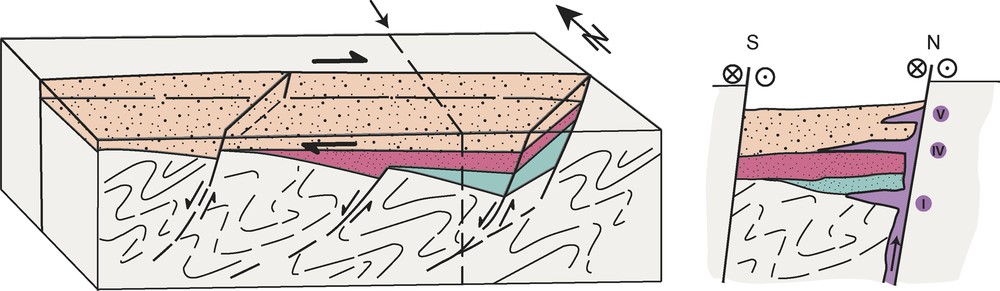
Pull-apart model proposed for the development of the Stephanian–Permian Anayet Basin. The north–south cross-section shows the role of the northern margin fault of the basin as the feeding channel for the construction of the volcanic edifices. See Fig. 3A for the legend.
The end of the Variscan orogeny in the western part of the Axial Zone was marked by granite intrusions and wrench-dominated transpression (Carreras and Druguet, 2014). The emplacement of the Cauterets–Panticosa batholith and the Eaux Chaudes granite 8 km to the east and the northeast of the Anayet Basin, respectively (Fig. 1B), took place under dextral transpressional conditions (Gleizes et al., 1998) between 301 and 305 Ma (Denèle et al., 2014; Ternet et al., 2004). The beginning of the transtensional conditions generally proposed for the opening of the Pyrenean Permian basins took place between 295 and 303 Ma in the Anayet Basin, according to the fossil record (Fig. 2). This time span is too small to accommodate such a change in the tectonic regime. In fact, the Grey Unit is probably younger, as evidenced by the emplacement of the first volcanic event between 272 and 278 Ma in the Midi d’Ossau (Briqueu and Innocent, 1993), the only reliable age constraint for the onset of the basin opening. The evolution from calc-alkaline (I) to alkaline (IV and V, Fig. 2) compositions of the Anayet volcanism has been related to a variation from transtensional to extensional conditions during the Upper Permian (Galé, 2005; Lago et al., 2004). The lack of absolute ages for the IV and V volcanic episodes makes it difficult to establish the time span when the change in the tectonic conditions occurred. Nevertheless, the presence of 259 Ma alkaline basalts in the Devonian slates of the basement (Rodríguez-Méndez et al., 2014) probably marks the beginning of the extensional regime. Taking into account that the first volcanic episode is related to the first stages of the formation of the Anayet Basin and it is dated from 272 to 278 Ma, the dextral transtensional conditions lasted during around 20 Ma.
One of the main questions regarding the stratigraphic evolution of the Anayet Basin is the deficient correlation between the biostratigraphic data and the available absolute ages (summarized in Fig. 2). The first post-Variscan deposits in the area are the limestones of the Grey Unit that contain Stephanian–Lower Autunian plants (Bixel et al., 1985; Ríos et al., 1987); taking into account the uncertainty of the continental subdivision, a Stephanian–Autunian age could be equivalent to Kasimovian to Asselian stages subsequent to the Sakmarian one (Fig. 2). Nevertheless, samples representative of the two cycles of the volcanic episode I interbedded within the Grey Unit in the Midi d’Ossau area yield ages between 272 and 278 Ma (Briqueu and Innocent, 1993) that rather suggest a connection with Kungurian–Roadinian stages and imply a minimum difference of 17 Ma between the biostratigraphic- and isotopic-derived ages (Fig. 2). Revisiting the fossil record of the Grey Unit could probably solve this age variation and provide a more accurate limit for the post-Variscan deposits.
6 Conclusions
The Anayet Basin (Huesca, Spain) is located in the central part of the Pyrenean Axial Zone. This basin consists of four main Stephanian–Permian sedimentary units of continental origin: the Grey, Intermediate, Lower Red and Upper Red units, from bottom to top. This paper shows significant less thickened units with regard to previous works. The westward spreading of these units is larger the younger they are and its deposition was coeval with the emplacement of Permian calc-alkaline to alkaline volcanic rocks, ranging from 272–278 to 259 Ma (Briqueu and Innocent, 1993; Rodríguez-Méndez et al., 2014). The evolution from calc-alkaline to alkaline of the volcanic rocks interbedded in the basin attests to a geodynamic evolution from transtension to extension that probably began around 259 Ma. This extensional regime continued in the Triassic and was responsible for the emplacement of the ophites in the Pyrenees.
The current structure of the basin reflects a positive inversion tectonics resulting from the overall north–south shortening during the Alpine compression. The opening of the basin took place in a pull-apart setting associated with the dextral motion of two WNW–ESE-trending strike-slip faults that were connected by transverse N50° E-trending faults. These faults are interpreted as pre-Stephanian fractures reactivated during the late- to post-orogenic extension of the Variscan Pyrenees. The wedge shape of the Grey/Intermediate and Lower Red units evidences several paleo-highs and depocenters that support the reactivation of the transverse fractures as listric normal faults and help to locate the sole normal fault of the pull-apart system in the eastern side of the basin.
In the light of the radiometric dating of the volcanic rocks interbedded with the sedimentary units, the age of the continental deposits of the Anayet Basin needs to be revisited and determined more accurately. In the meantime, we present an updated attempt of correlation among the main tectonic, magmatic and stratigraphic events that would have happened in the Anayet continental domain during Stephanian–Permian times. Further works will be conducted in other Stephanian–Permian basins of the Pyrenees to test the reliability of this working hypothesis.
Acknowledgments
This work has been supported by grants CGL2010-14869BTE and CGL2011-23755 (Science and Innovation Ministry [MICINN], Spain). L.R.M. acknowledges the Post-doctoral fellowship of the Basque Country Government (POS 2014 2 56). We are grateful to M. de Saint Blanquat for editorial tasks and to J. Malavielle and Y. Denèle for providing constructive reviews that have improved the manuscript.