

1 Introduction
On 21 January 1840, a few officers and crew members of Dumont d’Urville's expedition towards the south magnetic pole landed on the coast of “Terre Adélie” at the “Rocher du Débarquement”. They took rock samples that can be considered as the first ever collected on the Antarctica continent. Three of these samples were deposited at the “Muséum national d’histoire naturelle” (MNHN) in Paris, but, strangely enough, have never been studied. Natural history museums at Le Mans and Toulouse (France) also keep rock specimens reportedly sampled at the same place and in the same circumstances.
We report here the results of a petrological and geochemical study of the three historical samples kept in Paris. We compare them to those from Le Mans and Toulouse, and to two samples taken in 1993 and 2004 at the “Rocher du Débarquement”, in order to confirm or refute the alleged location of the 1840 landing place. One of the historical samples is modelled as a “P–T pseudosection”, with the aim of deducing its metamorphic P–T evolution. Finally, we discuss some consequences of this study on the Proterozoic history of the “Terre Adélie” craton, as well as on the icecap evolution in the landing area.
2 Historical background
The first confirmed sighting of the Antarctic continent dates back to the year 1820 (Headland, 1989): On 27 January 1820, Fabian Gottlieb Thaddeus von Bellingshausen on the Russian ship Vostok sighted a land now called Princess Martha Coast; on 30 January 1820, Edward Bransfield sighted the Antarctic Peninsula, which Nathaniel B. Palmer also observed in November 1820. The American sealer John Davis landed near Hughes Bay (Antarctic Peninsula) on 7 February 1821 (Bertrand, 1972; Headland, 1989). During the same years, other American sealers brought back from the South Shetland Islands rock specimens, which were unfortunately destroyed by fire in 1866, to the Lyceum of Natural History, New York City (Bertrand, 1972). Apparently, it was not until Dumont d’Urville's expedition reached Adélie Land, on 21 January 1840, that rock samples were taken from the continent – actually, from an islet at a little distance from the coast.
Jules Dumont d’Urville [1790–1842] sailed from Toulon on 7 September 1837, aboard the Astrolabe accompanied by the Zélée commanded by Charles Hector Jacquinot [1796–1879]. The main purpose of the expedition was to reach the south magnetic pole (Costa, 1958; Couturaud, 1986). By the end of November, the ships had reached the Strait of Magellan where the officers performed naturalist and geographic investigations. After Christmas 1837, Dumont d’Urville sailed towards the Weddell Sea, where the ships remained dangerously trapped for several days in the ice and failed to equal the most southerly latitude (74°34′ S) achieved in 1823 by James Weddell. After reaching the South Orkney and South Shetland Islands, the expedition attained the western coast of the Antarctic Peninsula, where they discovered Joinville Island and sighted a coast, already described by Bransfield and Palmer, which they named “Terre Louis-Philippe”. During the following months, the ships surveyed the Pacific Ocean. On 12 December 1839, they reached Hobart Town (Tasmania), from where Dumont d’Urville and Jacquinot planned to sail towards the magnetic pole. They left Hobart on 1 January 1840 and sighted the Antarctic continent on 20 January. On 21 January 1840, a few sailors of the Astrolabe followed by men of the Zélée disembarked on a small island of a rocky archipelago, at “400–600 metres” off the inaccessible ice-capped coast and ca. 4 km beyond the polar Antarctic Circle. This landing, apparently the first on the Antarctic continent outside the peninsula, and the rock sampling have been recounted by Dumont d’Urville (1840), Le Guillou (1842) and Dubouzet (in Dumont d’Urville, 1846–1853, t. 8, p. 148–153); several drawings by Aimé Coupvent-Desbois also depict the scene (e.g., inset drawing in Fig. 1). Here is a translation of the report by Joseph Dubouzet, the second officer of the Zélée:
“It was nearly nine o’clock [in the afternoon] when, to our delight, we landed on the western part of the westernmost and highest islet. The shallop of the Astrolabe had arrived a moment before us.” After a short ceremony, the men emptied a bottle of Bordeaux wine and started some scientific observations: “The rock was nude and did not even show the slightest trace of lichens. […] Each of us took the hammer and began to hurt the rock, but the latter, of a granitic nature, was so hard that we could only detach small pieces. Fortunately, following the crest of the island, the sailors discovered large fragments of rock detached by frosts, and they boarded them in our canoes. In examining them closely, I recognized a perfect resemblance between these rocks and small fragments of gneiss that we had found in the stomach of a penguin the day before.”
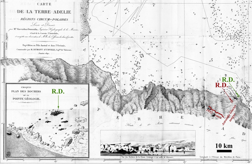
Terre Adélie map by Vincendon-Dumoulin. Extracted from Dumont d’Urville (1840; ©BNF); green circle and R.D.: “Rocher du Débarquement” as reported in 1840; red circle, R.D. and red line: “Rocher du Débarquement” and coastline as reported in 1952 (Perroud, 1955); dotted line: route followed by the Astrolabe.
The sailors also boarded a few Adélie penguins that Hombron and Jacquinot (1841, p. 320) later on described as Catarrhactes Adeliae. The hydrographer Clément Adrien Vincendon-Dumoulin [1811–1858] drew the map of the coast (Fig. 1; published in Dumont d’Urville, 1840). Dumont d’Urville gave the islet and the coast beyond the names “Rocher du Débarquement” and “Pointe Géologie”, respectively, whereas the whole land was called “Terre Adélie”, in honour of Dumont's wife Adèle. In the following days, the expedition followed the coast westward to determine the approximate position of the South magnetic pole, which, being on the continent, was actually unreachable. They sighted the American ship Porpoise commanded by Charles Wilkes, who surveyed the same coast but did not manage to land on what is now called Wilkes Land. On 17 February, Dumont d’Urville's expedition reached Hobart, and the journey ended in Toulon on 6 November 1840.
On 8 May 1842, Dumont d’Urville, his wife Adèle and his son died in the flames of the first French railway disaster, at Meudon, near Paris. The scientific results of the mission were then published by officers of the expedition, with the help of a few scientists (see Couturaud, 1986). Three rock samples of the “Rocher du Débarquement” were officially deposited in 1841 at the MNHN in Paris (Table 1), one by Élie Le Guillou, chief surgeon of the Zélée, and two others by Jacques Bernard Hombron, chief surgeon of the Astrolabe, although the latter has not set foot in Antarctica, since he stayed at Hobart during the journey towards the continent. Jules Grange (1848–1854) published the geological results of the expedition; he mentions Hombron's samples (vol. 2, pp. 214–215), but omitted the contribution of Le Guillou who, after having conflicted with many members of the expedition (see Le Guillou, 1850), became marginalized (Couturaud, 1986). When the use of the polarizing microscope developed a few decades later, no one thought of studying the first rocks ever taken from the Antarctic continent, and these specimens remained forgotten for 175 years.
Rock specimens mentioned in this study.
| Label | Repository | Donation | Annotation | Description | |
| 8F636 | MNHN Paris | 1841 | E. Le Guillou | “gneiss à gros grains gris rougeâtre” | Crd + Kfs + Bt migmatitic gneiss |
| 8G177 | MNHN Paris | 1841 | B. Hombron | “gneiss à gros grains, rougeâtre, feldspath rouge et mica brun” | Crd + Kfs + Bt migmatitic gneiss |
| 8G178 | MNHN Paris | 1841 | B. Hombron | “gneiss leptinoïde, à grains fins, presque compact, gris verdâtre avec mica bronze” | mesocratic amphibolite |
| RPM93-49B | Saint-Etienne | 1993 | R. P. Menot | Sampled at Rocher du débarquement | Crd + Kfs + Bt migmatitic gneiss |
| GD04-74 | Saint-Etienne | 2004 | G. Duclaux | Sampled at Rocher du débarquement; m-sized enclaves within gneiss | mesocratic amphibolite |
| 2008-2-934 | MHN Le Mans | 1934 | J. Le Page | “Granit pris à l’île Adelida dernière découverte de Dumont d’Urville” | Quartz diorite (Berthois, 1935) |
| MIN2013 0 1–5 | MHN Toulouse | 1878? | G. Roquemaurel | “roches détachées de la Terre Adélie découverte en janvier 1840 […]” | 5 samples, mostly of volcanic rocks |
A few other samples, reportedly taken on Adélie Land during the expedition, emerged from the collections of the natural history museums at Le Mans and Toulouse (France). Le Mans museum stores a rock specimen (ref. 2008.2.934) reportedly sampled in “Terre Adélie” in 1840 and donated to the museum in 1934 by J. Le Page (Berthois, 1935). An old label displays the following markings: “Granit pris à l’île Adelida, dernière découverte de Dumont d’Urville”, while another hand added “Terre Adélie. Antarctique”. Gaston de Roquemaurel, the second officer of the Astrolabe (Couturaud, 1986; Raynaud and Raynaud, 2001), collected five rock samples now stored at the Toulouse museum (ref. MIN 2013 0 1–5). An old tag alleges them to be “roches détachées de la Terre Adélie…”. They also show old labels with numbers (27, 42, 47) suggesting that they have belonged to a larger rock collection, whose catalogue is unfortunately lost. Finally, Dumont d’Urville's collections were deposited at the Natural history museum of Caen after his death and almost completely destroyed in June 1944 during the battle of Normandy. They may have included rock samples, but Bigot (1935) did not mention any, while he described the geological collections of this museum.
In January 1912, the ship Aurora of the Australasian Antarctic Expedition sailed along the same coast (Mawson, 1942); the coastline of “Pointe Géologie” drawn by Mawson (1942, pl. 17) apparently reproduces Vincendon-Dumoulin's map. Later, polar expeditions led by Paul-Émile Victor in 1950–1952 located what is supposed to be the “Rocher du Débarquement” (Costa, 1958; Perroud, 1955), and showed that “Pointe Géologie” was actually an archipelago close to the mainland. Aubert de La Rüe and Tchernia (1951) and Heurtebize (1952a, 1952b) initiated petrological and geological works in the neighbouring of “Pointe Géologie” and further east at “Port-Martin”, respectively.
The geological survey of the area was indeed facilitated when the French Antarctic station “Dumont d’Urville” opened in 1956 at about 6 km from the purported landing point of 1840. A number of geological studies have shown that the “Rocher du Débarquement”, the “Pointe Géologie” archipelago and the adjacent coast belong to a Palaeoproterozoic formation (1.7 Ga), made of dominant Crd-bearing migmatitic gneiss and anatexite, with subordinate mafic enclaves and dykes (e.g., Bascou et al., 2013; Bellair, 1961a, 1961b; Gapais et al., 2008; Monnier, 1995; Monnier et al., 1996; Pelletier, 2001; Pelletier et al., 2005). The formation of “Pointe Géologie” is associated further east with Neoarchaean terranes, forming together the “Terre Adélie” craton (e.g., Duclaux, 2007; Duclaux et al., 2008; Ménot et al., 2005, 2007; Pelletier et al., 2002).
In 2006, the “Rocher du Débarquement” has been rated among the Historic Sites and Monuments in Antarctica (HSM-81).
3 Petrological and geochemical study
We present here a petrological and geochemical study of the three historical samples stored at the MNHN, a macroscopic description of those preserved in Le Mans and Toulouse museums, and a petrological study of two specimens sampled more recently at the supposed landing place (Table 1), in order to confirm the location of the latter. The analytical procedures are presented in Appendix SM1. Mineral abbreviations are from Whitney and Evans (2010).
3.1 Historical samples from the expedition
Cordierite-bearing migmatitic gneiss. Two of the three MNHN samples have a very similar macroscopic aspect. These are Le Guillou's sample (8F636), labelled “gneiss à gros grains gris rougeâtre” (coarse-grained grey-reddish gneiss), and one of Hombron's samples (8G177: Fig. 2a) described as “gneiss à gros grains, rougeâtre, feldspath rouge et mica brun” (coarse-grained gneiss, reddish, with red feldspar and brown mica). They are coarse-grained and foliated gneiss, with abundant cm-sized crystals of pink K-feldspar, which give the rock a pinkish leucocratic aspect. Quartz, cordierite and biotite are also visible with the naked eye. The preferred concentration of biotite and quartz + feldspars in alternate layers indicates an incipient migmatisation, although a planar deformation is still clearly visible, with individual crystals flattened parallel to the foliation. No conspicuous lineation is visible. Le Guillou's sample (8F636) is slightly richer in biotite and less coarse-grained than Hombron's sample (8G177).
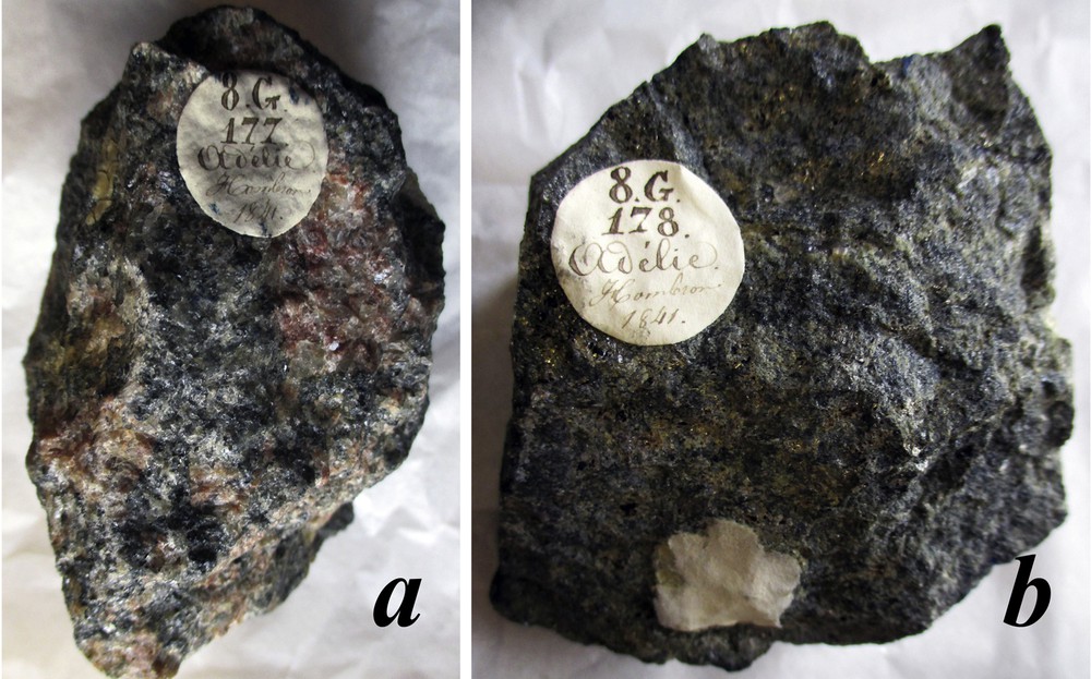
Photographs of some pieces of the historical samples. Each sample consists of a dozen similar pieces; the diameter of the tags is 1.8 cm: a: “8G177 Adélie Hombron, 1841”; b: “8G178 Adélie Hombron, 1841”.
Under the optical and scanning electron microscopes, the two samples are almost undistinguishable. Biotite appears subhedral; anhedral quartz crystals display slight undulose extinction, and cordierite is largely unaltered. K-feldspar in the form of coarse microcline crystals is more abundant than plagioclase, and exhibits perthitic exsolution lamellae (Fig. 3a), but no Carlsbad twin. Crystals are commonly replaced by quartz + albite intergrowths (i.e., myrmekite) at their rims. Sillimanite, apatite, zircon and magnetite are minor phases (Fig. 3a). Under the scanning electron microscope (SEM), magnetite crystals show 10-μm-sized inclusions of spinel and an irregular corona of muscovite, mainly at the contact with quartz.

The samples at the scanning electron microscope. a: Crd migmatitic gneiss 8G177 (from Hombron); back-scattered electron (BSE) image; see microcline (kfs) with perthitic lamellae (p). b: Mesocratic amphibolite 8G178 (from Hombron); BSE. c: detail of Ms + Pmp pseudomorph in 8G178 (see frame in b); map of minerals after classification of element maps.
The mineral compositions were obtained at the electron microprobe (Table 2; see Appendix SM1 for the analytical conditions). Microcline composition (sample 8F636: Or88Ab11An00Ce01; 8G177: Or91Ab08An00Ce01) as well as that of plagioclase (8F636: Or01Ab60An39; 8G177: Or01Ab65An34) are very similar in both samples (Table 2; Fig. 4). Cordierite also shows similar XMg ratios in the two samples (8F636: XMg = Mg/(Mg + Fe + Mn) = 0.71; 8G177: XMg = 0.70; Table 2), as well as biotite (8F636: XMg = 0.60; 8G177: XMg = 0.65). Biotite shows Tschermak substitution (8F636: Phl29Ann34Mn-Ann4East28Prw4; 8G177: Phl35Ann30Mn–Ann3East26Prw6) and a noticeable F-content (8F636: XF = F/(F + Cl + OH) = 0.124 ± 0.027; 8G177: XF = 0.098 ± 0.025; Table 2).
Composition of the minerals in the migmatitic gneiss.
| Plagioclase | Microcline | Biotite | Cordierite | ||||||||||
| 8F636 | 8G177 | RPM93-49B | 8F636 | 8G177 | RPM93-49B | 8F636 | 8G177 | RPM93-49B | 8F636 | 8G177 | RPM93-49B | ||
| nb | 7 | 21 | 11 | 4 | 4 | 1 | 12 | 18 | 18 | 6 | 33 | 44 | |
| Si | 2.572 | 2.627 | 2.576 | 2.978 | 2.978 | 2.982 | Si | 5.423 | 5.467 | 5.433 | 4.979 | 4.959 | 4.981 |
| Al | 1.425 | 1.377 | 1.418 | 1.028 | 1.033 | 1.022 | AlIV | 2.577 | 2.533 | 2.567 | 1.021 | 1.041 | 1.019 |
| Fe3+ | 0.004 | 0.001 | 0.002 | 0.002 | 0.001 | 0.002 | AlVI | 0.667 | 0.690 | 0.656 | 3.002 | 2.980 | 2.978 |
| Ti | 0.001 | 0.001 | 0.001 | 0.000 | 0.001 | 0.000 | Ti | 0.328 | 0.210 | 0.248 | 0.001 | 0.001 | 0.001 |
| Mn | 0.001 | 0.001 | 0.001 | 0.001 | 0.001 | 0.001 | Fe2+ | 1.825 | 1.630 | 1.674 | 0.494 | 0.531 | 0.484 |
| Mg | 0.000 | 0.000 | 0.000 | 0.001 | 0.001 | 0.000 | Mn | 0.049 | 0.055 | 0.048 | 0.074 | 0.079 | 0.079 |
| Ca | 0.400 | 0.345 | 0.404 | 0.002 | 0.001 | 0.000 | Mg | 2.822 | 3.205 | 3.145 | 1.424 | 1.424 | 1.465 |
| Na | 0.610 | 0.654 | 0.614 | 0.106 | 0.082 | 0.179 | Ca | 0.002 | 0.001 | 0.005 | 0.002 | 0.001 | 0.002 |
| K | 0.009 | 0.008 | 0.007 | 0.871 | 0.887 | 0.817 | Na | 0.038 | 0.043 | 0.045 | 0.021 | 0.028 | 0.019 |
| Ba | 0.000 | 0.000 | 0.000 | 0.007 | 0.006 | 0.000 | K | 1.830 | 1.796 | 1.818 | 0.001 | 0.001 | 0.001 |
| ∑cat | 5.022 | 5.014 | 5.023 | 4.989 | 4.985 | 5.003 | ∑cat | 15.561 | 15.631 | 15.638 | 11.020 | 11.044 | 11.030 |
| XAn | 0.393 | 0.342 | 0.394 | 0.002 | 0.001 | 0.000 | F | 0.496 | 0.390 | 0.321 | – | – | – |
| XAb | 0.599 | 0.650 | 0.599 | 0.108 | 0.084 | 0.180 | OHa | 3.504 | 3.610 | 3.679 | – | – | – |
| XOr | 0.008 | 0.008 | 0.006 | 0.884 | 0.909 | 0.820 | |||||||
| XCe | 0.000 | 0.000 | 0.000 | 0.007 | 0.006 | 0.000 | XMg | 0.601 | 0.655 | 0.646 | 0.715 | 0.700 | 0.722 |
a Estimated by stoichiometry.

Feldspar compositions. Plagioclase and microcline from the Crd-bearing migmatitic gneiss; historical (8-F-836; 8-G-177) and modern (RMP93-49B) samples.
Bulk-rock compositions are presented in Table 3 (major elements) and 5 (trace elements; Appendix SM2; see Appendix SM1 for the method). They were used to calculate the abundance of the minerals in both samples (in vol.%; see Godard, 2009, and Appendix SM1 for the method). The results show that the rocks are cordierite-bearing gneiss, which contain, by decreasing order of abundance (in vol.% of 8G177 and 8F636, respectively): Qtz (35.3, 30.2); Crd (23.0, 23.1); microcline (15.6, 24.7); Pl (19.3, 12.3); Bt (3.3, 5.9); Mag (2.7, 3.3); Ilm (0.6, 0.5); Sill (0.2, 0.0); Ap (0.1, 0.0).
Bulk-rock compositions.
| wt.% | SiO2 | Al2O3 | Fe2O3a | MnO | MgO | CaO | Na2O | K2O | TiO2 | P2O5 | LOI | Total |
| Detect. limit | 0.01 | 0.01 | 0.01 | 0.001 | 0.01 | 0.01 | 0.01 | 0.01 | 0.001 | 0.01 | 0.01 | |
| 8G177 (H) | 66.12 | 15.59 | 8.31 | 0.231 | 2.54 | 1.32 | 1.58 | 2.55 | 0.577 | 0.10 | 0.84 | 99.75 |
| 8F636 (LG) | 62.92 | 15.76 | 9.67 | 0.224 | 2.81 | 0.88 | 1.18 | 4.01 | 0.670 | 0.08 | 0.89 | 99.11 |
| 8G178 (H) | 56.39 | 15.88 | 8.81 | 0.344 | 5.90 | 4.62 | 0.56 | 3.47 | 0.443 | 0.15 | 3.58 | 100.10 |
a Total Fe; Crd migmatites (8G177, 8F636) and mesocratic amphibolite (8G178), from Hombron (H) and Le Guillou (LG).
The chemistry of the major elements is compatible with either a granitic or pelitic protolith for both samples, as shown by various binary diagrams (Fig. 7 in Appendix SM2). The two samples also show an almost identical REE pattern (Fig. 5a), with similar total REE contents (227–274), high LREE fractionation (La/Sm = 4.6–4.8), negative Eu anomaly (Eu/Eu* = 0.5) and moderate HREE fractionation (Gd/Lu = 2.5–2.8). The REE (Fig. 5a) and trace-element (Fig. 5b) patterns for 8G177 and 8F636 are also very similar to those of the Post-Archaean Average Australian Shale (PAAS), a geochemical standard proposed by Taylor and McLennan (1985) from metapelitic rocks of the Australian part of the same craton.

REE and trace element patterns. a: REE; b: trace-elements. Historical samples of Crd migmatitic gneiss (8G177, 8F636), and mesocratic amphibolite (8G178), compared with the Post-Archaean Average Australian Shale (PAAS) standard of Taylor and McLennan (1985).
Mesocratic amphibolites: The third MNHN specimen (8G178: Fig. 2b), donated by Hombron, is macroscopically very different from the above gneiss samples. Described as “gneiss leptinoïde à grains fins presque compacte, gris verdâtre avec micas bronzé” by Grange (1848-1854), it is a fine-grained, almost equigranular, greenish and mesocratic rock, where only a few mm-sized biotite flakes are distinguishable with the naked eye.
Under the optical and electron microscopes, the rock appears made up of quartz crystals, mm-sized biotite flakes with included prehnite lamellae, clinoamphibole and numerous microcrystalline aggregates of muscovite + pumpellyite ± calcite ± albite ± quartz (Fig. 3c). Cummingtonite, with its distinctive twinning, magnetite, titanite, apatite and epidote are minor phases; calcite fills some late veinlets up to 10 μm in thickness.
The composition of the mafic minerals, obtained at the electron microprobe (Table 4), shows a higher XMg ratio than those in the cordierite gneiss (biotite: XMg = 0.84; clinoamphibole: XMg = 0.74; cummingtonite: XMg = 0.70; Table 4). Biotite is a phlogopite (Phl73Ann16Mn-Ann1East0Prw11) rich in F (XF = F/(F + Cl + OH) = 0.28); muscovite is close to the end-member, with little phengite substitution (Ms81Pg5Mrg3[Mg,Fe,Mn]-Cel11), and clinoamphibole is magnesio-hornblende, following the classification of Hawthorne et al. (2012). The average of 140 analyses from the muscovite + pumpellyite + albite + quartz aggregate of Fig. 3b gives a composition (Si2.25Al1.81Ti0.00Fe0.07Mn0.01Mg0.16Ca0.24Na0.05K0.46O8) roughly compatible with that of some feldspar (Si2+xAl2−xCa1−x(Na, K)xO8), except for the alkalis, which were possibly lost during the pseudomorphing process.
Composition of the minerals in the mesocratic amphibolites.
| Biotite | Mg-hornblende | Cum. | Muscovite | Pumpellyite | |||||
| 8G178 | GD04-74 | 8G178 | GD04-74 | 8G178 | 8G178 | GD04-74 | 8G178 | GD04-74 | |
| nb | 9 | 12 | 5 | 16 | 33 | 62 | 20 | 11 | 5 |
| Si | 5.774 | 5.761 | 6.864 | 6.735 | 7.812 | 6.188 | 6.267 | 3.045 | 2.992 |
| AlIV | 2.226 | 2.239 | 1.136 | 1.265 | 0.188 | 1.812 | 1.733 | – | – |
| AlVI | 0.162 | 0.120 | 0.458 | 0.378 | 0.056 | 3.825 | 3.718 | 2.572 | 2.220 |
| Ti | 0.214 | 0.155 | 0.091 | 0.084 | 0.007 | 0.001 | 0.001 | 0.001 | 0.007 |
| Fe2+ | 0.897 | 0.900 | 1.253 | 1.331 | 1.826 | 0.102 | 0.102 | 0.208 | 0.294 |
| Fe3+a | – | – | 0.000 | 0.000 | 0.069 | – | – | – | – |
| Mn | 0.014 | 0.032 | 0.072 | 0.104 | 0.185 | 0.027 | 0.025 | 0.028 | 0.020 |
| Mg | 4.706 | 4.881 | 3.500 | 3.413 | 4.739 | 0.088 | 0.215 | 0.227 | 0.528 |
| Ca | 0.012 | 0.007 | 1.673 | 1.821 | 0.117 | 0.024 | 0.034 | 1.888 | 1.930 |
| Na | 0.098 | 0.061 | 0.332 | 0.368 | 0.044 | 0.051 | 0.036 | 0.015 | 0.005 |
| K | 1.530 | 1.559 | 0.070 | 0.090 | 0.004 | 1.800 | 1.786 | 0.015 | 0.005 |
| ∑cat. | 15.632 | 15.715 | 15.449 | 15.589 | 15.047 | 13.918 | 13.917 | 8.000 | 8.000 |
| O | 20.000 | 20.000 | 22.000 | 22.000 | 22.000 | 20.000 | 20.000 | 11.632 | 11.206 |
| F | 1.121 | 1.416 | – | – | – | 0.019 | 0.019 | – | – |
| OHa | 2.879 | 2.584 | 2.000 | 2.000 | 2.000 | 3.981 | 3.981 | 1.368 | 1.794 |
| XMg | 0.838 | 0.840 | 0.736 | 0.719 | 0.702 | 0.406 | 0.629 | 0.490 | 0.627 |
a Estimated by stoichiometry; Fe3+ in amphibole is the minimal value that gives a correct cation distribution in the sites.
The bulk-rock composition of sample 8G178 is distinct from that of the cordierite gneiss (Table 3; Table 5 in Appendix SM2). The same is true for the calculated abundance of the minerals (in vol.% of 8G178): 28.1 Cam; 26.9 Qtz; 32.2 Ms + 5.2 Pmp + 0.6 Ab (i.e., ca. 38% of Ms-bearing pseudomorphs); 2.6 Bt; 2.6 Mag; 1.8 Cum; 0.0 Ap. The major-element chemistry is intermediate between basic and pelitic compositions (see Appendix SM2). With respect to the cordierite-bearing gneiss, sample 8G178 shows a lower REE total content (103.9), lower LREE and HREE fractionations (La/Sm = 2.75; Gd/Lu = 1.92) and a less marked Eu anomaly (Eu/Eu* = 0.7) (Fig. 5a).
Other samples: The sample stored at Le Mans museum (2008.2.934: see Section 2, Table 1) consists of a mesocratic medium-grained granular rock. Berthois (1935) studied a thin section of this rock and described it as made up of oligoclase (An34, determined by Michel-Levy's Carlsbad-albite method), hornblende with relics of uralitised pyroxene, minor biotite and quartz. It is thus a quartz diorite, very different from the above samples. Equally dissimilar are the five samples stored at Toulouse museum (MIN 2013 0 1-5; https://commons.wikimedia.org/wiki/File: Roquemaurel_Roches_Terre_Adélie_MHNT_MIN_2013_0_1-5.jpg). Three of these (1, 2, 5) are apparently volcanic rocks, showing feldspar and mafic phenocrysts in an aphanitic or microcrystalline greyish matrix. Two samples (3, 4) display subhedral mafic crystals in a fine-grained felsic matrix. None of these samples contain the cm-sized reddish crystals of K-feldspar that are so abundant at the “Rocher du Débarquement.”
3.2 Modern samples from the “Rocher du Débarquement”
Two samples from the “Rocher du Débarquement”, stored in the Antarctic collections of the Jean-Monnet University (Saint-Étienne, France), were chosen for a comparative study with the above historical samples.
Cordierite-bearing migmatitic gneiss: The first sample (RPM93-49B) was collected on the “Rocher du Débarquement” by R.-P. Ménot, in 1993 and is representative of the main rock present on the islet. It is a migmatitic coarse-grained gneiss with cm-sized reddish K-feldspar crystals. The other minerals, namely biotite, cordierite, quartz, plagioclase, magnetite, apatite and sillimanite, are clearly visible under the optical microscope. The macroscopic aspect of this sample, and its petrological features observed under the optical and electron microscopes are very similar to the above 8F636 and 8G177 historical sample. Perthitic exsolution lamellae, myrmekite and even the small muscovite coronas between quartz and magnetite are also present. The mineral compositions are very similar too (see RPM93-49B vs. 8F636 and 8G177 in Table 2).
Mesocratic amphibolites: The second sample (GD04-74) was collected on the “Rocher” by Guillaume Duclaux in 2004; it is representative of metre-sized enclaves of fine-grained mesocratic amphibolite boudinaged within the migmatitic gneiss. The petrological features of this sample are identical to those of Hombron's 8G178 sample: the rock is almost equigranular, with quartz, clinoamphibole, numerous microcrystalline muscovite-bearing aggregates and a few biotite flakes with included prehnite lamellae, although, relative to 8G178, cummingtonite is apparently absent and pumpellyite is less abundant in the muscovite aggregates. Mineral compositions are also similar (see GD04-74 vs. 8G178 in Table 4).
4 Discussion
4.1 Confirmation of the landing point
Based on its position, size and configuration, the “Rocher du Débarquement” has been identified with the northernmost islet of “Pointe Géologie” Archipelago (e.g., Perroud, 1955). According to Vincendon-Dumoulin's map (Fig. 1; Dumont d’Urville, 1840), the coordinates of the landing site are 66°34′29″ S, 137°50′25″ E relative to the Paris Meridian, and thus 140°10′39″ E of Greenwich (green circle in Fig. 1), whereas the actual latitude and longitude of the islet apex are 66°36′18.82″ S and 140°4′17.04″ E (Perroud, 1955; red circle in Fig. 1). The errors in latitude (3.4 km), longitude (4.7 km) and total distance (5.8 km) appear acceptable, if one considers the inaccuracies of the navigation at the time and the difficulties in using a compass in a region close to the southern magnetic pole.
Hombron's and Le Guillou's historical specimens stored at the MNHN in Paris are very similar to the cordierite-bearing gneiss (8G177, 8F636) and mesocratic amphibolite (8G178) recently sampled on the “Rocher du Débarquement” (see Section 3.2). This indeed confirms that the “Rocher” is the real place of the 1840 landing, which, at worst, could have occurred on a neighbouring islet of the same archipelago, made up of the same rocks.
On the other hand, the rocks preserved at Le Mans and Toulouse and reportedly sampled in “Terre Adélie” (see Sections 2 and 3.1, Table 1) are completely dissimilar to the rocks from the “Rocher du Débarquement”. Since Dumont d’Urville did not land on other sites of the Adélie Land coast, they clearly come from other places. The quartz diorite from “île Adelida” (Le Mans: 2008.2.934) could have been sampled in the Magellan Strait at the “Adelaida” Archipelago, where Grange (1848–1854, vol. 1, p. 199), while publishing the geological results of the mission, mentioned diorite dykes. As for the five samples stored at the Toulouse Museum (MIN 2013 0 1–5), their old labels with a numbering up to 47 suggest that they have belonged to a larger collection, which may have included rocks from Adélie Land. However, the five remaining specimens, volcanic for the most part, are totally different from the study rocks (Section 3.1); they possibly come from Patagonia, the Magellan Straight, Pacific Ocean, Indonesia or South Shetland, visited by the expedition. Samples 8F636, 8G177 and 8G178 of the MNHN in Paris are thus the only surviving pieces of the first rocks ever taken on the Antarctic Continent.
4.2 Icecap shrinking since 1840
Vincendon-Dumoulin carried out his topographical survey from the ship's desk, over 250 km between longitudes 136°E and 142°E. On the resulting map, of which our Fig. 1 is extracted, the icecap edge lies northwards relative to the present coastline. The apparent gap between them is of 7.3 km on average, with a maximum of 22 km at Port-Martin (see fig. 2 in Perroud, 1955). In January 1840, Charles Wilkes surveyed a much larger portion of the same coast, between 100°E and 150°E, and his map, although less accurate, also shows a coastline shifted northward of the present coast by a few kilometres (Knox and Adélie coasts) up to ca. 100 km (Sabrina, Banzare and Clarie coasts) (see fig. 7 in Bertrand, 1972).
Indeed, most of these discrepancies resulted from underestimating the distance to the coast (see Dumont d’Urville, 1846–1853, vol. 1, ch. 8) and from mistaking ice shield for land. However, the relative position of the “Rocher du Débarquement”, reported at 1.7 km from the ice-capped land in 1840 (Fig. 1), 11.4 km in 1952 (Perroud, 1955) and 11.4 km today (Google map), suggests that, in this area, the icecap retracted southwards of ca. 9 km between 1840 and 1952, at the end of the Little Ice Age. The comparison of the coastlines reported in 1840 and 1952 (see red line in Fig. 1; Perroud, 1955) corroborates this evolution.
4.3 Insight into the geology of Terre Adélie
The “Rocher du Débarquement” consists of Crd-bearing migmatitic gneiss, whose composition in major, trace and rare-earth elements is very close to that of the PAAS standard (Fig. 5), indicating a pelitic protolith. It is however slightly depleted in HREE relative to the PAAS standard (Fig. 5a), which we attribute here to the presence in the same formation of HREE-enriched restitic garnet-bearing paragneiss. The Crd migmatitic gneiss encloses boudins of a fine-grained, mesocratic and almost equigranular rock, whose chemistry is intermediate between basic and pelitic compositions, and probably representative of a volcano-clastic or calc-silicate origin. It was boudinaged and folded close to the metamorphic peak. Several micro-structures (prehnite lamellae in partially chloritised biotite, Ms + Pmp + Ab pseudomorphs after feldspar, calcite veinlets…) indicate static alteration during retrogression under prehnite–pumpellyite-facies conditions.
A theoretical P–T diagram (or “pseudosection”) was modelled for the composition of sample 8G177 (Fig. 6), using the Thermocalc software of Powell and Holland (1988) with an upgraded version of the thermodynamic data set of Holland and Powell (1990, 1998). The modelled molar composition is: (SiO2)72.04(Al2O3)10.01(CaO)1.39(MgO)4.17(FeO)7.03(K2O)1.77(Na2O)1.67(TiO2)0.47O1.60, with aH2O = 1.0 (i.e. saturation in water), O being deduced from the modal abundance of magnetite (see Appendix SM3 for further details). The result shows that the main paragenesis (Qtz + Crd + Pl + Ksp + Mag + Bt + Ilm + Sil) is stable in a narrow P–T field extending from ca. 2.5 kbar & 620 °C to 3.2 kbar & 670 °C (Fig. 6a). The boundary of this field towards higher values of P is well constrained by the Crd-in curve, whereas the Sil-out curve that bounds the same field at lower P (Fig. 6b) is not so relevant, since it is not clear whether the minor sillimanite observed in the sample was relict or still stable at the metamorphic peak. Migmatisation indicates that the solidus curve was overstepped and the rock reached the field Melt + Qtz + Crd + Pl + Ksp + Mag + Bt + Ilm ± Sil, close to 3.2 kbar and 665 °C (green field in Fig. 6a and b). For these P–T conditions, the model provides mineral abundances, which, converted from mol.% to vol.%, are close to those calculated for the real 8G177 rock (see Section 3.1): Qtz, 35.8 vs. 35.3 vol.%; Crd, 21.5 vs. 23.0; Pl, 17.2 vs. 19.3; Ksp, 13.8 vs. 15.6; Bt, 7.2 vs. 3.3; Mag, 2.0 vs. 2.7; Ilm, 1.5 vs. 0.6; Sil, 0.9 vs. 0.2. The peak P–T conditions obtained for similar cordierite migmatites by Pelletier et al. (2005) at “Pointe Géologie” (4–6 kbar, 700 ± 50 °C for ) are slightly higher than those obtained here (ca. 3.2 kbar, 665 °C for ). This disparity can be partly explained by different hypotheses on water activity (0.9 vs. 1.0), since the solidus curve shifts towards lower T when increases.
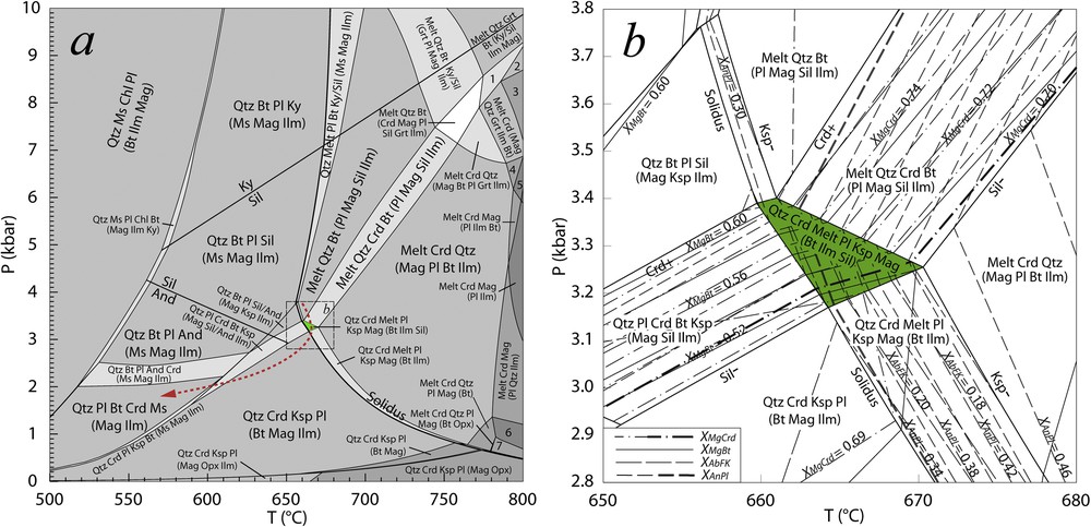
P–T pseudosection for the historical sample 8G177. a: general model; b: enlargement and isopleths near the peak conditions (see the frame in a). Red dashed line: proposed P–T path near the peak and during retrogression (see text); green field: stability field for the main paragenesis (see text). For each assemblage, minerals are listed in decreasing order of modal abundance; the minerals in brackets are less than 5 vol.%; 1: Melt Grt Crd (Qtz Ilm Mag Bt Sil); 2: Melt Crd Grt (Qtz Ilm Mag Sil); 3: Melt Crd (Mag Grt Qtz Ilm); 4: Melt Crd (Mag Ilm Bt Qtz); 5: Melt Crd Mag (Ilm Bt); 6: Melt Crd Qtz Mag Pl; 7: Melt Crd Qtz Mag Pl (Opx).
The isopleths for cordierite (XMg = 0.70) and plagioclase (XAn = 0.34) cross in this narrow P–T field (green area in Fig. 6b), confirming that these minerals equilibrated close to the peak of metamorphism. This is not the case, however, for biotite and microcline, whose real compositions (XMg = 0.65, XAb = 0.08, respectively) do not match exactly those provided by the model (XMg = 0.51–0.60, XAb = 0.21–0.18: Fig. 6b). This seems due to the effect of retrogression, during which biotite was partly chloritised and microcline exsolved albite-rich perthitic lamellae. The difference in composition between the modelled K-feldspar at the peak (XAb ≈ 0.2) and the real perthitic microcline (XAb = 0.08) can well be explained by the exsolution of albite lamellae (ca. 10 vol.%) in the latter (Fig. 3a). Apart from these observations, the retrograde P–T path is poorly documented. We suggest a clockwise path that allows cordierite to remain stable for as long as possible (red dotted line in Fig. 6a), reducing the prospect of alteration of this mineral, which is well preserved in the rock. According to the model, the evolution from the peak towards the muscovite-bearing field at 570 °C and 1.9 kbar produces a diminution in the spinel content of magnetite (XAl from 0.046 down to 0.025); at contact with quartz, i.e. in excess of SiO2, such release of Al could generate the muscovite coronas observed around magnetite (see Section 3.1).
This study indicates low-P amphibolite-facies conditions at the metamorphic peak for this region of the “Terre Adélie” craton, corresponding to an abnormally high geothermal gradient (ca. 60 °C/km), even greater than that evidenced by Pelletier et al. (2005). No trace of a high-P overprint has been recorded here, contrary to what is suspected 120 km further east, at the edge of the “Terre Adélie” craton (see review in Godard and Palmeri, 2013).
5 Conclusions
(a) The first rocks sampled on the Antarctic continent by Dumont d’Urville's expedition in January 1840 are cordierite-bearing migmatitic gneiss and mesocratic amphibolite. They are very similar to the rocks observed at the “Rocher du Débarquement” (Adélie Land), confirming that this was the actual place where the expedition landed.
(b) The other rock specimens reportedly sampled in “Terre Adélie” during the same expedition and preserved at Le Mans and Toulouse do not come from Antarctica, but from other places where the crew disembarked.
(c) The migmatitic paragneiss reached peak P–T conditions (ca. 670 °C and 3.2 kbar, deduced by modelling a P–T pseudosection) that indicate an abnormal high-T gradient (ca. 60 °C/km) during the metamorphic event that affected the “Terre Adélie” craton 1.7 Ga ago.
(d) The positions of the icecap edge in 1840, 1952 and today suggest that the icecap has shrunk by 9 km in this area, at the end of the Little Ice Age.
Acknowledgments
Gabriel Carlier and Caroline Noyes are warmly thanked for having facilitated our investigation on the MNHN collections. Didier Morel did the same for the Le Mans sample. We thank the “Institut polaire français Paul-Émile-Victor” for access facilities to the “Rocher du Débarquement”. We sincerely thank George Gibson, Jacques Touret, Jean and Juliette Mergoil for their comments, which were of great help in revising the manuscript. The research benefited from the financial support by the Italian “Progetto Nazionale di Ricerca in Antartide” (PdR 13/B2.07-Palmeri).