Plan
Comptes Rendus

Special issue Comptes-Rendus Geoscience: The Mayotte seismo-volcanic crisis of 2018–2021 in the eastern Comoros archipelago (Mozambique channel)
Comptes Rendus. Géoscience, Volume 354 (2022) no. S2, pp. 1-6.
Métadonnées
Reçu le :
Accepté le :
Publié le :
DOI : 10.5802/crgeos.196
Jérôme van der Woerd 1 ; Vincent Famin 2, 3 ; Eric Humler 4

1 Institut Terre et Environnement de Strasbourg, CNRS UMR 7063, Université de Strasbourg, 67000 Strasbourg, France
2 Université de Paris, Institut de physique du globe de Paris, CNRS, UMR 7154, F-75005 Paris, France
3 Université de La Réunion, Laboratoire GéoSciences Réunion, F-97744 Saint-Denis, France
4 Laboratoire de Planétologie et Géodynamique, CNRS UMR 6112, Université de Nantes, 44322 Nantes, France
Licence : CC-BY 4.0
Droits d'auteur : Les auteurs conservent leurs droits
@article{CRGEOS_2022__354_S2_1_0,
     author = {J\'er\^ome van der Woerd and Vincent Famin and Eric Humler},
     title = {Special issue {\protect\emph{Comptes-Rendus} {Geoscience}:} {The} {Mayotte} seismo-volcanic crisis of 2018{\textendash}2021 in the eastern {Comoros} archipelago {(Mozambique} channel)},
     journal = {Comptes Rendus. G\'eoscience},
     pages = {1--6},
     publisher = {Acad\'emie des sciences, Paris},
     volume = {354},
     number = {S2},
     year = {2022},
     doi = {10.5802/crgeos.196},
     language = {en},
}
TY  - JOUR
AU  - Jérôme van der Woerd
AU  - Vincent Famin
AU  - Eric Humler
TI  - Special issue Comptes-Rendus Geoscience: The Mayotte seismo-volcanic crisis of 2018–2021 in the eastern Comoros archipelago (Mozambique channel)
JO  - Comptes Rendus. Géoscience
PY  - 2022
SP  - 1
EP  - 6
VL  - 354
IS  - S2
PB  - Académie des sciences, Paris
DO  - 10.5802/crgeos.196
LA  - en
ID  - CRGEOS_2022__354_S2_1_0
ER  - 
%0 Journal Article
%A Jérôme van der Woerd
%A Vincent Famin
%A Eric Humler
%T Special issue Comptes-Rendus Geoscience: The Mayotte seismo-volcanic crisis of 2018–2021 in the eastern Comoros archipelago (Mozambique channel)
%J Comptes Rendus. Géoscience
%D 2022
%P 1-6
%V 354
%N S2
%I Académie des sciences, Paris
%R 10.5802/crgeos.196
%G en
%F CRGEOS_2022__354_S2_1_0
Jérôme van der Woerd; Vincent Famin; Eric Humler. Special issue Comptes-Rendus Geoscience: The Mayotte seismo-volcanic crisis of 2018–2021 in the eastern Comoros archipelago (Mozambique channel). Comptes Rendus. Géoscience, Volume 354 (2022) no. S2, pp. 1-6. doi : 10.5802/crgeos.196. https://comptes-rendus.academie-sciences.fr/geoscience/articles/10.5802/crgeos.196/

Version originale du texte intégral (Proposez une traduction )

The challenges posed by unexpected and poorly known natural hazard are manifold: scientific, technical and societal. Until 2018, Mayotte was classified as a zone of moderate seismicity and low probability of volcanism among French territories. The onset of the seismic crisis offshore Mayotte in May 2018, which appeared to be volcanic in the course of its discovery, has triggered an unprecedented mobilization of the French scientific, administrative and political communities (Figure 1). Understanding the event, building a message, communicating to the population: all had to be constructed and invented, with the additional difficulty that nothing was visible given that the eruption happened offshore on the several kilometers deep oceanic floor.

Figure 1.

Summary of major events, decisions and actions triggered by the seismo-volcanic events starting 10 May 2018 in Mayotte.

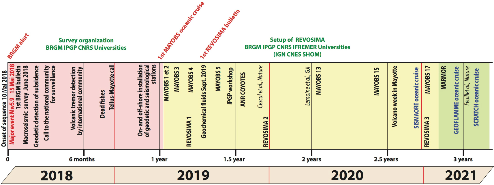
Even though it is not possible to cite all the actions of the French scientific and institutional communities in response to the seismo-volcanic crisis of Mayotte, some milestones appear in the chronology of crisis management. After the first earthquake swarms of 10 May 2018, the local bureau of the BRGM in Mayotte in charge of seismic risk was mobilized and issued an alert. The large chock of magnitude Mw5.9 occurred on 15 May 2018, 5 days after continuous and increasing seismicity that worried the population in a time of social unrest and tension, with the difficulty for the authorities to transmit an audible message on an unexpected and worrisome event. A macroseismic survey was launched in June 2018. As the seismicity remained important, the seismological community outlined projects for on- and off-shore deployment of seismic stations based on preliminary locations with an inadequate network. In July 2018, the French geodetic survey (IGN) noticed an unexplained change in ground motions recorded by the GNSS stations. The scientific community interpreted these ground motion changes as due to the deflation of magmatic chamber in the crust or in the mantle, with or without seafloor eruption [Lemoine et al. 2020]. Later in November 2018, a strong and long single-frequency, very low frequency seismic signal is observed several thousand kilometers from Mayotte on global seismic networks. Such a “tremor” is usually associated with magmatic circulation or reservoir draining [Cesca et al. 2020].

Governmental and scientific institutions convened and organized their effort towards understanding the seismo-volcanic event in November 2018, leading to the creation of the “Réseau de surveillance Volcanique et Sismologique de Mayotte”—REVOSIMA (Volcanic and Seismological Monitoring Network of Mayotte), with the requirement to develop scientific knowledge, identify and transmit alerts, disseminate regular information. CNRS-INSU opened a call for survey projects at the beginning of 2019. This rapidly mobilized funding allowed the deployment of ocean bottom seismometers, and the first MAYOBS-1 cruise that led to the discovery of a new submarine volcano [Feuillet 2019, Feuillet et al. 2021], later called “Fani Maoré”. Since then, recurrent campaigns have been organized to monitor the evolution of the Fani Maoré volcano (up to MAYOBS-27 at the time of writing). In addition, three oceanographic cruises have been conducted to better understand the geologic and geodynamic setting of this volcanic eruption in 2021 (Figure 2), “SISMAORE” and “GEOFLAMME” with the R/V Pourquoi Pas?, and “SCRATCH” using the R/V Marion Dufresnes II. These surveys deployed a huge panel of marine geophysical techniques and resulted in the collection of 16 sediment cores and 18 dredges over the northern Mozambique channel, which will give work to scientists for several decades.

Figure 2.

Summary of research efforts since the 2018 Mayotte seismic and volcanic crisis. Elements shown include seismic/GNSS stations installed in the Comoros archipelago, the number of which has doubled since 2018. Also shown are the oceanographic cruises and their main operations (geophysical surveys, sediment coring and or seafloor dredging): SISMAORE (December 2020–February 2021), GEOFLAMME (April–May 2021), SCRATCH (July 2021), and MAYOBS-1 to -23 (March 2019–July 2022).

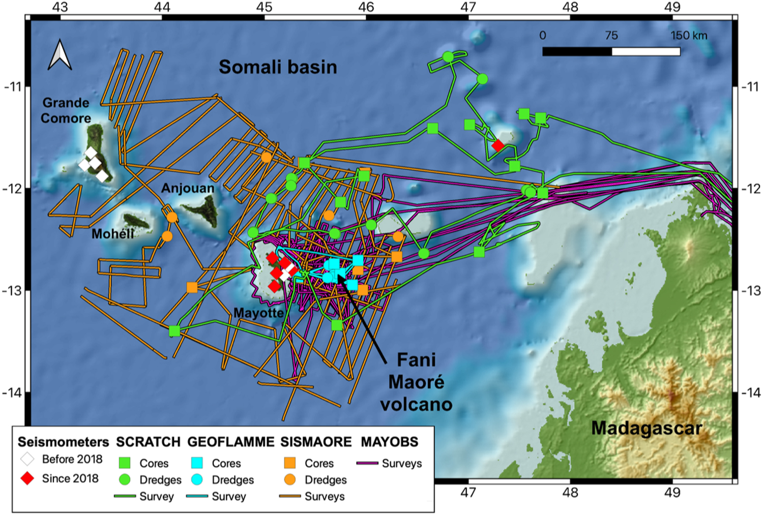
To sustain this unprecedented scientific effort, the French National Research Agency (Agence Nationale de la Recherche—ANR) granted pluri-annual funding to three ambitious projects involving international and multidisciplinary scientific teams: “COYOTES” aiming at understanding the geodynamics of the northern Mozambique channel, “SUBSILAKE” with the objective of monitoring geochemical changes in a crater lake of Mayotte in response to the submarine eruption, and “MARMOR” aiming at building a multi-technique geophysical network of submarine eruption monitoring in the area. The newly discovered geo-hazard in the northern Mozambique channel also motivated the Comorian and French authorities to reinforce their international collaboration through the “HATARI” Interreg project funded by the European Union and coordinated by the Réunion Regional Council.

Four years after the onset of the crisis, while it is apparently coming to a rest, efforts to understand what is happening and to put in place an efficient monitoring network are still ongoing, at the national and international level. For the French community, scientific and risk managers, the implementation of an underwater volcano monitoring network is not only a challenge but may set an example (Marmor project https://www.marmor-project.org/). The recent Mayotte seismo-volcanic crisis has triggered already a large set of scientific studies as can be seen from the many scientific articles and communications over the last 4 years. In this special issue, our aim is to gather a wide spectrum of scientific works around the event, without being exhaustive, in order to give an overall understanding of the crisis. It is composed of 19 articles, including details of the seismic and volcanic sequence, the various risks associated to its occurrence, its societal impact, but also first local and regional understanding of the geological, volcanic and geodynamic context of Mayotte and the Comoros archipelago.

The first part of this thematic issue is a compilation of the latest advances about the geological and geodynamic context of the Mozambique channel. Most of these advances are direct outcomes from the ANR COYOTES project (https://anr.fr/Projet-ANR-19-CE31-0018), from oceanic cruises such as SISMAORE (doi:10.17600/18001331), and from the now regular MAYOBS surveys (doi:10.18142/291). In Thinon et al. [2022] for instance, extension of the submarine volcanism in the northern Mozambique channel is evidenced, and the regional geodynamics is investigated by means of marine geophysics. This first part also questions the nature of the lithosphere beneath the Comoros archipelago, by probing its thermal state from literature and newly published heat flow measurements [Rolandone et al. 2022] and its structure from teleseismic receiver functions [Dofal et al. 2022]. Seismic reflection across the new volcano East of Mayotte provides unprecedented insights about the chronology and architecture of volcanic seamount construction in this zone [Masquelet et al. 2022]. Ocean bottom volcanic geomorphology is also investigated from high-resolution bathymetry and towed camera on the eastern submarine slope of Mayotte [Puzenat et al. 2022].

In a second part of the thematic issue, a set of studies on seismicity, geodesy, petrology, and gas emissions focuses on the development of the Mayotte seismo-volcanic sequence and its evolution. Despite an inadequate network before 2019, the first year of seismicity of the Mayotte sequence has been carefully analyzed and is now presented in a new catalogue of seismicity [Mercury et al. 2022]. A teleseismic source study of the largest events at the onset of the sequence reveals their link to magmatic fracturing and transport [Morales-Yáñez et al. 2022]. With the seafloor and onland seismic monitoring in place since 2019, the large amount of data is investigated using automatic detection techniques [Retailleau et al. 2022]. Although disseminated on few oceanic islands, large ground deformations (20–25 cm) are monitored via geodesy, which are explained by magma transfer at depth in the volcanic edifice [Peltier et al. 2022]. Eruptive material collected on the seafloor thanks to oceanographic campaigns helps constraining eruptive scenarios [Berthod et al. 2022]. The conditions required for the genesis and eruption of phonolitic lavas such as those found in this new volcano are explored [Andújar et al. 2022]. Monitoring lavas flows with an hydroacoustic network seems a promising development for the study of the eruptive sequence [Bazin et al. 2022]. Onland gases emissions on Petite Terre offer a window on magmatic processes occurring at depth during volcanic unrest [Liuzzo et al. 2022]. The co-eruptive evolution of these emissions also impacts the water chemistry of maars as shown by geochemical monitoring and modeling of the Dziani Dzaha Lake on Petite Terre in Mayotte [Cadeau et al. 2022].

In a third part, the possible consequences and impacts of the eruption and its possible evolution are explored in term of hazard and risk assessment. Knowledge of the geological nature of the surface rocks and deposits constrain possible site effects during seismic shaking [Roullé et al. 2022]. Being prepared and preventing damages in case of seismic shaking can be explored for crisis management [Taillefer et al. 2022]. The unstable submarine slopes of Mayotte could be prone to landslides themselves triggering tsunamis [Poulain et al. 2022].

The last part addresses how one communicates in the midst of a crisis with so many unknowns. A study based on news accounts reveals the various facets of the narrative from the various communities involved [Devès et al. 2022]. Another study explores the perception of the crisis and how it is revealed in the languages [Mori 2022].

This issue is a step toward the better understanding of the multiple sides of a volcanic eruption. It gathers together a wide spectrum of scientific approaches and studies, which testify of the strong involvement of the scientific community for assessing natural hazard and risk to the populations. In addition, the organization of an operational multi-partner monitoring system in emergency and in a little known geological area may serve as a model for other regions subject to equivalent hazards and risks.

Conflicts of interest

Authors have no conflict of interest to declare.

Acknowledgements

The authors are grateful towards François Chabaux for his suggestion to publish a special issue on the Mayotte seismo-volcanic crisis and for his constant support during the preparation of the issue. They also thank Adenise Lopes and the Comptes Rendus Geoscience team for their help in the editorial processing.


Bibliographie

[Andújar et al., 2022] J. Andújar; B. Scaillet; M. Moreira; I. Di Carlo; A. Le Friant; M. Bickert; F. Paquet; S. J. Jorry; N. Feuillet Experimental evidence for the shallow production of phonolitic compositions at Mayotte, C. R. Géosci., Volume 354 (2022) no. S2, pp. 225-256 | DOI

[Bazin et al., 2022] S. Bazin; J.-Y. Royer; F. Dubost; F. Paquet; B. Loubrieu; A. Lavayssière; C. Deplus; N. Feuillet; É. Jacques; E. Rinnert; I. Thinon; É. Lebas; D. Pierre; L. Retailleau; J.-M. Saurel; A. Sukhovich; R. Bonnet Initial results from a hydroacoustic network to monitor submarine lava flows near Mayotte Island, C. R. Géosci., Volume 354 (2022) no. S2, pp. 257-273 | DOI

[Berthod et al., 2022] C. Berthod; J.-C. Komorowski; L. Gurioli; E. Médard; P. Bachèlery; P. Besson; P. Verdurme; O. Chevrel; A. Di Muro; A. Peltier; J.-L. Devidal; S. Nowak; I. Thinon; P. Burckel; S. Hidalgo; C. Deplus; B. Loubrieu; D. Pierre; S. Bermell; M. Pitel-Roudaut; Y. Réaud; S. Fouchard; M. Bickert; A. Le Friant; F. Paquet; N. Feuillet; S. L. Jorry; Y. Fouquet; E. Rinnert; C. Cathalot; E. Lebas Temporal magmatic evolution of the Fani Maoré submarine eruption 50 km east of Mayotte revealed by in situ sampling and petrological monitoring, C. R. Géosci., Volume 354 (2022) no. S2, pp. 195-223 | DOI

[Cadeau et al., 2022] P. Cadeau; D. Jézéquel; A. Groleau; A. Di Muro; M. Ader Impact of the seismo-volcanic crisis offshore Mayotte on the Dziani Dzaha Lake, C. R. Géosci., Volume 354 (2022) no. S2, pp. 299-316 | DOI

[Cesca et al., 2020] S. Cesca; J. Letort; H. N. T. Razafindrakoto; S. Heimann; E. Rivalta; M. P. Isken; M. Nikkhoo; L. Passarelli; G. M. Petersen; F. Cotton; T. Dahm Drainage of a deep magma reservoir near Mayotte inferred from seismicity and deformation, Nat. Geosci., Volume 13 (2020), pp. 87-93 | DOI

[Devès et al., 2022] M. H. Devès; S. Moirand; L. Le Vagueresse; G. Robert Mayotte’s seismo-volcanic “crisis” in news accounts (2018–2021), C. R. Géosci., Volume 354 (2022) no. S2, pp. 391-415 | DOI

[Dofal et al., 2022] A. Dofal; L. Michon; F. R. Fontaine; E. Rindraharisaona; G. Barruol; H. Tkalčić Imaging the lithospheric structure and plumbing system below the Mayotte volcanic zone, C. R. Géosci., Volume 354 (2022) no. S2, pp. 47-64 | DOI

[Feuillet et al., 2021] N. Feuillet; S. Jorry; W. C. Crawford; C. Deplus; I. Thinon; E. Jacques; J. M. Saurel; A. Lemoine; F. Paquet; C. Satriano; C. Aiken; O. Foix; P. Kowalski; A. Laurent; E. Rinnert; C. Cathalot; J.-P. Donval; V. Guyader; A. Gaillot; C. Scalabrin; M. Moreira; A. Peltier; F. Beauducel; R. Grandin; V. Ballu; R. Daniel; P. Pelleau; J. Gomez; S. Besançon; L. Geli; P. Bernard; P. Bachelery; Y. Fouquet; D. Bertil; A. Lemarchand; J. Van der Woerd Birth of a large volcanic edifice offshore Mayotte via lithosphere-scale dyke intrusion, Nat. Geosci., Volume 14 (2021), pp. 787-795 | DOI

[Feuillet, 2019] N. Feuillet MAYOBS1 cruise, 2019 (RV Marion Dufresne), https://doi.org/10.17600/18001217

[Lemoine et al., 2020] A. Lemoine; P. Briole; D. Bertil; A. Roullé; M. Foumelis; I. Thinon; D. Raucoules; M. de Michele; P. Valty; R. Hoste Colomer The 2018–2019 seismo-volcanic crisis east of Mayotte, Comoros islands: seismicity and ground deformation markers of an exceptional submarine eruption, Geophys. J. Int., Volume 223 (2020), pp. 22-44 | DOI

[Liuzzo et al., 2022] M. Liuzzo; A. Di Muro; A. Luca Rizzo; F. Grassa; M. Coltorti; M. Ader The composition of gas emissions at Petite Terre (Mayotte, Comoros): inference on magmatic fingerprints, C. R. Géosci., Volume 354 (2022) no. S2, pp. 275-316 | DOI

[Masquelet et al., 2022] C. Masquelet; S. Leroy; M. Delescluse; N. Chamot-Rooke; I. Thinon; A. Lemoine; D. Franke; L. Watremez; P. Werner; F. Paquet; C. Berthod; V. Cabiativa Pico; D. Sauter The East-Mayotte new volcano in the Comoros Archipelago: structure and timing of magmatic phases inferred from seismic reflection data, C. R. Géosci., Volume 354 (2022) no. S2, pp. 65-79 | DOI

[Mercury et al., 2022] N. Mercury; A. Lemoine; C. Doubre; D. Bertil; J. Van Der Woerd; R. Hoste-Colomer; J. Battaglia Onset of a submarine eruption east of Mayotte, Comoros archipelago: the first ten months seismicity of the seismo-volcanic sequence (2018–2019), C. R. Géosci., Volume 354 (2022) no. S2, pp. 105-136 | DOI

[Morales-Yáñez et al., 2022] C. Morales-Yáñez; Z. Duputel; L. Rivera Exploring the link between large earthquakes and magma transport at the onset of the Mayotte volcano-seismic crisis, C. R. Géosci., Volume 354 (2022) no. S2, pp. 137-152 | DOI

[Mori, 2022] M. Mori Storytelling, language, and the earthquake swarm of May 2018: insights into Shimaore and Kibushi from narrative analysis, C. R. Géosci., Volume 354 (2022) no. S2, pp. 417-437 | DOI

[Peltier et al., 2022] A. Peltier; S. Saur; V. Ballu; F. Beauducel; P. Briole; K. Chanard; D. Dausse; J.-B. De Chabalier; R. Grandin; P. Rouffiac; Y.-T. Tranchant; M. Bès de Berc; S. Besançon; P. Boissier; C. Broucke; C. Brunet; K. Canjamalé; E. Carme; P. Catherine; A. Colombain; W. Crawford; R. Daniel; G. Dectot; N. Desfete; C. Doubre; T. Dumouch; C. Griot; M. Grunberg; H. Jund; P. Kowalski; F. Lauret; J. Lebreton; F. Pesqueira; F. Tronel; P. Valty; J. van der Woerd Ground deformation monitoring of the eruption offshore Mayotte, C. R. Géosci., Volume 354 (2022) no. S2, pp. 171-193 | DOI

[Poulain et al., 2022] P. Poulain; A. Le Friant; R. Pedreros; A. Mangeney; A. G. Filippini; G. Grandjean; A. Lemoine; E. D. Fernández-Nieto; M. J. Castro Díaz; M. Peruzzetto Numerical simulation of submarine landslides and generated tsunamis: application to the on-going Mayotte seismo-volcanic crisis, C. R. Géosci., Volume 354 (2022) no. S2, pp. 361-390 | DOI

[Puzenat et al., 2022] V. Puzenat; N. Feuillet; J.-C. Komorowski; J. Escartín; C. Deplus; P. Bachèlery; C. Berthod; L. Gurioli; C. Scalabrin; C. Cathalot; E. Rinnert; B. Loubrieu; D. Pierre; M. Pitel-Roudaut; N. Tanguy; Y. Fouquet; S. J. Jorry; E. Lebas; F. Paquet; I. Thinon Volcano-tectonic structures of Mayotte’s upper submarine slope: insights from high-resolution bathymetry and in-situ imagery from a deep-towed camera, C. R. Géosci., Volume 354 (2022) no. S2, pp. 81-104 | DOI

[Retailleau et al., 2022] L. Retailleau; J.-M. Saurel; M. Laporte; A. Lavayssière; V. Ferrazzini; W. Zhu; G. C. Beroza; C. Satriano; J.-C. Komorowski Automatic detection for a comprehensive view of Mayotte seismicity, C. R. Géosci., Volume 354 (2022) no. S2, pp. 153-170 | DOI

[Rolandone et al., 2022] F. Rolandone; J. Poort; C. Masquelet; S. Leroy; I. Thinon; A. Lemoine; F. Paquet Heat flow measurements in the Northern Mozambique Channel, C. R. Géosci., Volume 354 (2022) no. S2, pp. 35-46 | DOI

[Roullé et al., 2022] A. Roullé; M. Baillet; D. Bertil; C. Cornou Site effects observations and mapping on the weathered volcanic formations of Mayotte Island, C. R. Géosci., Volume 354 (2022) no. S2, pp. 317-341 | DOI

[Taillefer et al., 2022] N. Taillefer; D. Bertil; C. Negulescu; A. Roullé; C. Iasio; S. Auclair; R. Quique Seismic damage scenarios for Mayotte: a tool for disaster management, C. R. Géosci., Volume 354 (2022) no. S2, pp. 343-359 | DOI

[Thinon et al., 2022] I. Thinon; A. Lemoine; S. Leroy; F. Paquet; C. Berthod; S. Zaragosi; V. Famin; N. Feuillet; P. Boymond; C. Masquelet; N. Mercury; A. Rusquet; C. Scalabrin; J. Van der Woerd; J. Bernard; J. Bignon; V. Clouard; C. Doubre; E. Jacques; S. J. Jorry; F. Rolandone; N. Chamot-Rooke; M. Delescluse; D. Franke; L. Watremez; P. Bachèlery; L. Michon; D. Sauter; S. Bujan; A. Canva; E. Dassie; V. Roche; S. Ali; A. Hamid Sitti Allaouia; C. Deplus; S. Rad; L. Sadeski Volcanism and tectonics unveiled in the Comoros Archipelago between Africa and Madagascar, C. R. Géosci., Volume 354 (2022) no. S2, pp. 7-34 | DOI


Commentaires - Politique


Ces articles pourraient vous intéresser

Volcanism and tectonics unveiled in the Comoros Archipelago between Africa and Madagascar

Isabelle Thinon; Anne Lemoine; Sylvie Leroy; ...

C. R. Géos (2022)


Volcano-tectonic structures of Mayotte’s upper submarine slope: insights from high-resolution bathymetry and in-situ imagery from a deep-towed camera

Valentine Puzenat; Nathalie Feuillet; Jean-Christophe Komorowski; ...

C. R. Géos (2022)


Onset of a submarine eruption east of Mayotte, Comoros archipelago: the first ten months seismicity of the seismo-volcanic sequence (2018–2019)

Nicolas Mercury; Anne Lemoine; Cécile Doubre; ...

C. R. Géos (2022)