

 CC-BY 4.0
1. Introduction
Studies of the Triassic stratigraphy across the Arabian Plate have a long history. Early work was by staff belonging to international oil companies but remained proprietary. The first formal, widely available definitions of Triassic lithostratigraphy were published between the late 1950s and the 1970s in the series Lexique Stratigraphique International, including volumes on Saudi Arabia, Qatar, Iraq, Iran, Lebanon, Syria and Jordan, Yemen and adjacent areas of southern Oman. The United States Geological Survey published a series of Professional Papers on the Geology of the Arabian Peninsula, with volumes on Saudi Arabia, south-western Iraq and Yemen, also in the 1960s. Together these volumes from the Lexique Stratigraphique International and the USGS Professional Papers provide the original definitions of the Jilh and Minjur Formations and their equivalents.
Most of the Arabian Plate suffers from poor biostratigraphic age control during the Triassic. It is only in a few sections near the margins of the Arabian Plate or outcrops such as those described in Part I, that have yielded good faunal or floral evidence. This emphasises the importance of new biostratigraphic data from the Central Saudi Arabian outcrops, for better understanding of the regional picture. Work by the BRGM [Le Nindre et al. 1990a] had identified thin marine units within dominantly siliciclastic, continental to paralic Sudair, Jilh and Minjur formations. These marine incursions are obvious candidates for Maximum Flooding Surfaces (MFS) addressed in Part II. Extensive documentation of their sedimentology, fauna, flora and stratigraphic architecture is provided in Part I.
The Triassic Jilh Formation and the Minjur Sandstone of Saudi Arabia crop out in a 50 km-wide belt between latitudes 28°N and 21°N, along the eastern margin of the Arabian Shield (Figure 1). Together with the Permian–Early Triassic Khuff Formation and the Early Triassic Sudair Shale, these formations form an unconformable cover over the Pre-Permian rocks, and are in turn unconformably overlain by Jurassic and younger formations [Figure 2, Vaslet et al. 1983]. During the USGS-supported mapping of Saudi Arabia in the 1960s [Powers et al. 1966; Powers 1968], initial analysis of the lithology of the Jilh and Minjur formations led to their interpretation as alternating marine or and paralic-continental units. Powers [1968] suggested a “Late Permian (?Kungurian–Kazanian)” age for the Khuff Formation, a “Permian–Triassic (Tatarian–Buntsandstein)” age for the Sudair Shale, a “Buntsandstein–Muschelkalk” age for the Jilh Formation, and a “Keuper to Liassic” age for the Minjur Sandstone. The available data also suggested that the intra-formational boundaries were isochronous [Powers 1968]. Subsequently, Le Nindre et al. [1987, 1990a] gave a revised description of the lithostratigraphy, biostratigraphy and sedimentology of the Permian–Triassic at outcrop, based on the results of the cover rock geological mapping program at 1:250,000 scale by the Directorate Mineral Resources of Saudi Arabia (DMMR) and France’s Geological Survey (BRGM). More recent publications give a detailed description and interpretation of the underlying Khuff Formation [e.g., Vachard et al. 2005; Vaslet et al. 2005] and overlying Minjur Sandstone [Issautier et al. 2012a, b, 2019]. The objective of Part I is not to re-analyse and re-interpret the lithostratigraphy and the sedimentology already comprehensively documented by Le Nindre et al. [1987]. This information has also been published in the Explanatory Notes to the Geological Map Quadrangles (Figure 1), and in Le Nindre et al. [1990a, b], from which the results are briefly synthesized and summarised herein. Part I is specifically oriented to identification and biostratigraphic age calibration of the main T–R events in view of establishing an MFS-based sequence stratigraphy, reconstructing the depositional and structural evolution, and making regional correlations in Part II.
Simplified geological map of the Arabian Peninsula showing the quadrangles in which the Jilh Formation crops out. These quadrangles in Central Saudi Arabia were mapped by the DMMR (now Saudi Geological Survey) and France’s BRGM [Hawasina nappes in Oman not shown, Qatar Arch from Stewart et al. 2016].
Lithostratigraphic column of the Ar Rayn quadrangle (23°–24°N, 45–46°30′E), slightly updated from Vaslet et al. [1983].
The present paper describes the sedimentary evolution within the Jilh Formation, using precise biostratigraphic calibration, and the internal organization of the T–R depositional sequences. The biostratigraphic analysis, essentially based on conodonts collected from outcrops of the Jilh Formation and from the base of the Minjur Sandstone, and on ammonoids, makes it possible to define the age of the units at different latitudes, to establish the chronostratigraphic boundaries, and to demonstrate that successive Middle to Late Triassic transgressions had a strong northerly component. Part of the biostratigraphic data comes from samples collected in the 1980s and was synthesized in Le Nindre et al. [1990a]. New key results come from samples collected in 1991–1992 within the Qibah Quadrangle and were not studied previously. Conodont taxonomy has been updated. In addition, a revision of ammonoids from previous identifications, and a new specimen collected in 2016 has reinforced the conodont-based calibration. Inclusion of new data on Minjur Sandstone stratigraphy [Issautier et al. 2019] also provides a correlation tool within the Jilh–Minjur systems, in the subsurface and at the platform scale, regardless of lithologic variations.
Results, discussions, and conclusions are presented in two parts: Part I, the present paper, is dedicated to lithostratigraphy, paleoenvironments, ages, and subsequent stratigraphic geometry; a subsequent paper, Part II, will discuss sequence stratigraphy, structural evolution, subsurface correlations, and Triassic paleogeography.
2. Previous definitions
2.1. Jilh Formation
Initially defined by Bramkamp [1945, in Powers et al. 1966] as the “Jilh limestone member”, this unit was raised to the rank of formation (the Jilh Formation) by Steineke and Bramkamp [1952]. The type section was taken at Jilh al ’Ishar from 24°03′48′′N, 45°46′00′′E to 24°11′06′′N, 45°51′30′′E. In the type region (Wadi Ar Rayn Quadrangle, Figure 1), the formation, with a total thickness of 326 m, is generally consists of cross-bedded sandstone with clayey interbeds, incorporating several limestone and dolomite bands. However, the formation displays marked lateral variations across its outcrop area, essentially comprising continental sandstone in the southeast, and predominantly marine carbonate sediments in the northwest.
In the type region, Bramkamp and Steineke [in Arkell 1952] distinguished two units based on lithological analysis of the formation. From base to top, the “Lower Jilh” (142 m) comprises 81 m of quartzose sandstone alternating with clay, 25 m of gypsiferous clay, and 36 m of limestone containing interbeds of marl and fine-grained sandstone. From base to top, the “Upper Jilh” (184 m) displays 118 m of quartzose sandstone, the lower part of which contains interbeds of fine-grained sandstone with two thin beds of limestone at the midpoint, overlain by 66 m of sandstone and clay incorporating several beds of sandy limestone, in turn overlain by a bed of hard oolitic sandstone.
A fauna comprising the bivalve Myophoria sp. and fragments of ammonoid nuclei is recorded 45–55 m from the top of the formation [Powers 1968]. According to Arkell [1952], these cephalopods typify the Mid-Triassic, although Siberling [personal communication to Powers 1968] held the view that most of the specimens can be assigned to a Late Triassic genus. Based on data from the study of spores and pollen grains in formations intersected by drill holes, Powers [1968] nonetheless assigned an Early and Middle-Triassic age (Buntsandstein–Muschelkalk) to the Jilh Formation.
Sedimentologic data were subsequently provided by Sharief [1977, 1981], who described nine sedimentary facies in the Jilh Formation, including fluviatile, supratidal, coastal, and shallow-marine sediments deposited in cyclic units (“cyclothems”); the overall succession comprises interfingering regressive and transgressive intervals [Sharief 1981]. Sharief [1977] also mentioned the development of carbonate facies north of 25°30′N and of abundant evaporitic facies in the upper part of the formation around 26°30′N. Vaslet et al. [1983], Manivit et al. [1985a] and Vaslet et al. [1985a] assigned the Jilh Formation to the Anisian–Norian, ages principally based on conodonts and ammonoid faunas; mapping and sedimentologic analyses by these authors led to the definition of three units (lower, J1; middle, J2; and upper, J3), each corresponding to a sedimentary cycle. Manivit et al. [1985a] described a reference section at Khashm Dolqan near the original type section (24°13′N, 45°37′E to 24°12′N, 46°05′E). Northward and southward lateral variations along the outcrop were described by Le Nindre et al. [1990a].
2.2. Minjur Sandstone
Originally named the Upper Es Sirr Sandstone by Bramkamp [1950, in Powers et al. 1966], and subsequently recorded and defined as the Minjur Sandstone by Steineke and Bramkamp [1952] and Steinecke [in Arkell 1952], this formation was described by Powers [1968] as essentially composed of continental sandstones incorporating conglomerate lenses and clay intercalations.
The formation is 315 m thick in the type locality, “Khashm al Mānjur” (=Khashm al Khalta, 23°35′24′′N, 46°10′36′′E), but varies in thickness from 185 to 362 m. It contains plant debris and silicified wood remains. Powers [1968] assigned a Late Triassic age (Carnian, Middle Keuper) to the lower part of the formation from correlation with dated subsurface sequences, based on palynologic data. The upper part was said to contain unspecified Lower Jurassic microflora. Vaslet et al. [1985a] assumed a ?Norian to Rhaetian age based on previous work (Late Triassic) and on interpreted ages of the underlying Jilh Formation (Anisian–Norian). As mentioned above, this formation was further described in outcrop by Le Nindre et al. [1987, 1990a] and Issautier et al. [2012a, b]. Le Nindre et al. [1990a] confirmed a Norian age based on the conodont Epigondolella abneptis (Huckriede), recovered from carbonates near the base of the formation (26°50′N and northward).
In 2019, Issautier et al. [2019] proposed an updated stratigraphy for the Minjur Sandstone in outcrop and shallow subsurface. In the subsurface, palynology has established a fourfold biostratigraphic subdivision (partly illustrated here in Figure 12) extending from latest Carnian–early Norian to latest Rhaetian–Pliensbachian (Triassic–Early Jurassic). Subsequent to a period of subaerial exposure in the west, transgression in the early middle Norian was marked by marginal marine environments, with peak marine influence in the Middle Norian. Its signification in terms of MFS is discussed in Part II. This was followed by the development of a gently inclined alluvial or coastal plain. Palynology has also demonstrated an intra-Rhaetian hiatus which separates the Lower Minjur Formation from the Upper Minjur Formation. A variety of depositional environments are represented, including alluvial fans proximally, grading to fluvial, then to coastal plain and shallow marine environments distally. Regional evidence (chronostratigraphic chart in Part II) indicates that this hiatus appears comparable in importance to the Toarcian to Aalenian unconformity separating Sharland et al.’s [2001] Tectonic Mega-Sequences (TMS) AP6 and AP7.
An important aspect of the present study is the definition of the base of the Minjur Sandstone in outcrop, and the nature of the contact with the underlying Jilh Formation. The overall definition of the base of the Minjur Sandstone adopted in the different measured sections from the BRGM/DMMR mapping program is the following: generally, the base of the Minjur Sandstone in most of the sections was taken from beds of black, ferruginous, microconglomeratic sandstone with plant remains, debris of silicified wood, and sometimes the accumulation of silicified tree trunks. Lag deposits with quartz grains up to 2 cm in diameter and trough cross-stratification may also characterize this horizon. Thus, the basal Minjur beds contrast sharply with the underlying marginal marine deposits of the Jilh Formation although mixed facies of dolomite pebbles, reworked in thinly bedded sandstone, often marks the transition in the uppermost beds of the Jilh Formation.
3. Lithostratigraphy of the Jilh Formation
In the 1980s, the mapping program at 1:250,000 by the DMMR and BRGM surveyed the outcrops of the Jilh Formation over 880 km from latitude 21°07′N at Khashm Mishlah up to 28°10′N near Shamat al Akbad in nine quadrangles (Figure 1) from south to north: Sulayyimah [Vaslet et al. 1985b], Al Mulayh [Manivit et al. 1985b], Wadi Ar Rayn [Vaslet et al. 1983], Ad Darma’ [Manivit et al. 1985a], Al Faydah [Vaslet et al. 1985a], Buraydah [Manivit et al. 1986], Qibah (Robelin et al., surveyed in 1992–1993 and published in 1994]), Baqa’ [Vaslet et al. 1987], and Turubah [Lebret et al. 1999]. Lithostratigraphy, biostratigraphy and sedimentology of the formation were first published in the explanatory notes of the maps and then synthetized by Le Nindre et al. [1987, 1990a, b] from field and laboratory studies.
The three lithostratigraphic units (J1, J2, J3, or lower, middle, upper unit, respectively) originate from a sedimentological and sequential approach to overcome lithological variability, although fine-grained sediments dominate in J1, sandstone in J2, and carbonate in J3 [Le Nindre et al. 1987, 1990a, p. 198; Vaslet et al. 1983]. The three units are particularly well demonstrated in the vicinity of the of the Khashm Dolqan reference section (24°13′21′′N, 45°37′34′′E, Figure 3) and by the Khabra Halwah section—23°59′N—(see Section 4.2.4, Figure 8).
Reference section of the Jilh Formation at Khashm Dolqan, modified from 1:500 description of December 1981 by Y. M. Le Nindre, C. Cavelier, D. Vaslet, J. M. Brosse and J. Manivit.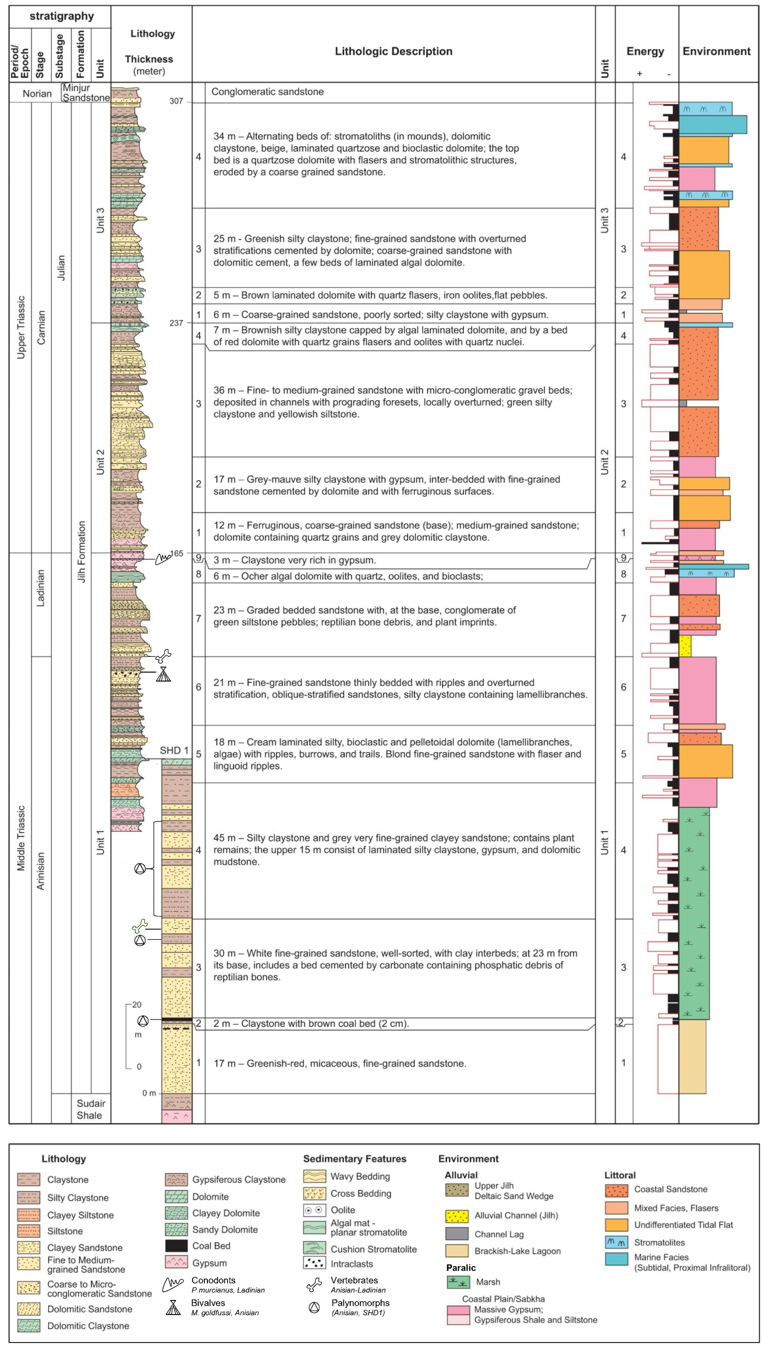
Depositional environment of the Jilh Formation along the N–S strike of the outcrops [modified after Le Nindre et al. 1987, 1990a]. Base of Khashm al Khalta section updated from Issautier et al. [2012a]. Previous biostratigraphic control shown in the sections is updated from the present work at Mudarraj-Didah (Qibah quadrangle). Mudarraj-Didah, Ibn al Fuhayd, Ar Rubay’iyah: new sections. See Figure 1 for location of quadrangles.
Typically, the Jilh Formation between latitudes 23°N and 25°N consists of three transgressive sequences of clay-siltstone, sandstone, and carbonate, in which the sandstone occupies a variable position depending on the type of sedimentary bodies it represents, and where the carbonates, marking the most offshore marine settings, cap each sequence. The latter thus are essential markers for correlations. A cuesta morphology is commonly associated with these cycles, facilitating lateral mapping between the sections.
- On the geological maps, between 1979 (first map surveyed) and 1999 (last map published), this three-fold nomenclature was variably applied depending principally on outcrop conditions. North of Lat. 25°30′N, three sequences were also recognized, but in fact four are stacked, the fourth (i.e., youngest) eroding the third. This stratigraphic geometry was interpreted as a transgressive erosional wedge by Le Nindre et al. [1987, 1990a]. Already, Vaslet et al. [1985a] within the Al Faydah quadrangle, and Manivit et al. [1986] within the Buraydah quadrangle (i.e., north of 25°N) had mentioned Late Carnian and Norian in respect of Unit J3 and Manivit [1987 in Le Nindre et al. 1987, Livre 2] had demonstrated an apparent south–north diachroneity of the lithostratigraphy, but, looking more carefully, uncertainties over ages and geometries remained. From these uncertainties was born the need for a revised stratigraphy using new biostratigraphic results coupled with modern Sequence Stratigraphy principles.
Historically, and where the three-fold subdivision was not fully applicable, “Lower Unit” and “Upper Unit” were used. The “Lower Unit”, represented on the maps with a clay or sandstone pattern, simply corresponds to the J1 Unit, dominantly clastic and unconsolidated, whose basal contact with the underlying Sudair Shale is commonly obscured beneath recent sediments (Figure 2).
3.1. Reference section
The reference section at Khashm Dolqan, (24°13′21′′N, 45°37′34′′E to 24°12′N, 46°05′E, Figure 1) near the original type section, has a total thickness of 307 m. The outcropping portion is supplemented by 79 m of section from the cored SHD-1 well (23°13′40′′N, 45°37′30′′E), drilled from the first dolomitic cuesta of the formation, representing the lower portion hidden under the Nafud Desert sands (Figures 3 and 4).
3.1.1. Lower boundary
In the SHD-1 well, the transition from the Sudair Shale below, to the Jilh Formation above, is gradational and marked by an upward increase of sandstone content, from red-brick claystone with gypsum, characteristic of the Sudair Shale, to greenish-red clayey sandstone and to white fine-grained micaceous sandstone. The base of the Jilh Formation is placed at the base of the first horizon of greenish-red, micaceous, fine-grained sandstone.
3.1.2. Upper boundary
The contact between the Jilh Formation and overlying Minjur Sandstone is placed on an erosional surface between a dolomitic mudstone with quartz-sand flasers, representing the last bed of the Jilh Formation, and a ferruginous sandstone with reworked clasts of dolomite, the first bed of the Minjur Sandstone.
3.1.3. Lithostratigraphic units and paleoenvironments
The formation in the reference section is subdivided into three units, named J1 (165 m), J2 (72 m) and J3 (70 m), from bottom to top. The section is described in detail in Figure 3. The column “Environments” depicts a seaward evolution of the sedimentation with time and two major flooding events, one at the top of Unit J1, and one at the top of Unit J3, in accord with our sequential units definitions. Ladinian and Julian (Lower Carnian) ages respectively are based on fossils content of this and of adjacent sections (see Section 5, and Supplementary Section A, Plate A.3).
3.2. Lithostratigraphy northward and southward from the reference section
3.2.1. Measured sections
The lithostratigraphic sections measured in the Jilh–Minjur systems from Lat. 22°11′N to Lat. 28°05′N, are shown at a reduced scale in Supplementary Section A with 5 plates and tables which provide locations of the key fossils and their age interpretation. They mention the original lithologic subdivisions of Le Nindre et al. [1990a], units and subunits.
Three sections measured after 1990, of which the lithostratigraphy was tentatively based on the adjacent Buraydah quadrangle, complement the description:
- The Jabal Mudarraj–Didah reference section for the Qibah Quadrangle (27°10′N) measured by BRGM in December 1991 (Supplementary Section B, Plate B.1).
- Two sections within the Buraydah Quadrangle: Ar Rubay’iyah (26°23′N)—Supplementary Section B, Plate B.2—and Ibn al Fuhayd (26°42′N—not published herein but used in Figure 4) measured in March 2016 by the SGS in a dedicated survey.
All these sections are represented on the north–south (N–S) transect of the facies and paleoenvironments (Figure 4).
3.2.2. Mapped units
The variations northwards and southwards of the reference section were described section by section by Vaslet in Le Nindre et al. [1987, 1990a] on the basis of the three units, J1, J2 and J3, despite discontinuous outcrop in places. Note that the Units J1 to J3 of the reference section were originally defined southward within the Wadi A Rayn quadrangle [Vaslet et al. 1983] at Khabrah Halwah (23°58′N, 44°49′E) as three informal lithologic assemblages named lower, middle and upper Jilh (see the Section 4.2.4 dedicated to this particular case with Figure 8). These three units and their subunits, are still in use in the individual descriptions of the lithostratigraphic sections, which are included herein (Supplementary Section A), especially for purpose of sample and key fossil’s location with the related biostratigraphic results.
Laterally, in the field, Units J1 to J3 were correlated on facies and on lithomorphology by using the presence of cuestas with soft material at the foot and hard benches of dolomite or sandstone, on their top (Figure 5). This method is reliable at quadrangle scale provided a laterally constant lithology is present. However, the new biostratigraphic studies have assigned ages to these lithological units which have proved facies diachroneity [Bruno Vrielynck, Edward T. Tozer, and Jacques Manivit in Le Nindre et al. 1987, 1990a] and the presence of disconformities. Complex and changing lithologies make the use of this lithomorphology uncertain over long distances.
Aerial views of the first cuestas of the Jilh Formation, near the location of the lithostratigraphic section “Safra ar Ruwaykibah”, Al Faydah Quadrangle. (Photos by Jacques Manivit.)
Therefore, at the outcrop scale, the three lithostratigraphic units are not differentiated and the formation is indistinctly mapped as TrJ (Triassic, Jilh) or TrJl (“lower Jilh”) and TrJu (“upper Jilh”) e.g., Vaslet et al. [1983]. Additional patterns are used where notable sandstone bodies or shales occur.
The Figure 4, shows the facies distribution along a N–S transect. Updated from previous work, it now indicates the location of the three new sections and the age calibrations obtained by biostratigraphy. This new approach, based on analysis of T–R depositional units and on biostratigraphy will be used for building a new Sequence and chronostratigraphy in the subsequent Part II paper.
3.3. Upper contact with the Minjur Sandstone
The upper contact with the Minjur Sandstone was recognized in most of the sections. It is defined in outcrop by lag deposits resting on a paleosol and by evidence of subaerial exposure, notably with plants and tree remains.
At Khashm Munayyifiyah (22°11′N, Al Mulayh Quadrangle), the base of the Minjur Sandstone is a channelised sandstone with mud pebbles and an erosional contact on the underlying paleosol. At Khashm Mawan (22°50N′, Al Mulayh Quadrangle), the base Minjur is a conglomeratic lag of rounded quartz, 2 cm in diameter, above a ferruginous surface, overlain by trough cross-bedded sandstone.
At Khashm al Khalta (23°38′N, Ar Rayn Quadrangle), the base Minjur, as recognized by Issautier et al. [2012a], is an incised high-energy paleo-river valley filled with black ferruginous, coarse-grained sandstone with planar (upper flow regime quartz lags) and trough cross-stratification. It contains debris of silicified tree branches, and plant imprints. Two tributaries of this type were observed within a 10 km radius. At Khabra Halwah (23°58′N, Ar Rayn Quadrangle), above a brecciated bed of dolomite in fine-grained sandstone, the basal Minjur is a conglomeratic coarse-grained sandstone overlain by a fine-grained sandstone with black hematite.
At al Gullah (24°19′N, Ad Darma’ Quadrangle), above the Kashm Dolqan section of the Jilh Formation, the basal Minjur is characterized by soil with gravel and poorly sorted coarse-grained sandstone with plant debris; it rests on supratidal fine-grained deposits with a reworked bed of dolomite in sandstone, and a ferruginous surface; below in the Khashm Dolqan section, transitional flasers of sandstone are present in the dolomite bearing bed.
In the south of the Al Faydah Quadrangle (25°08′N), the basal Minjur is a conglomeratic sandstone with ferruginous cement resting on a red-violet algal dolomite. At Safra ar Ruwaykibah (25°32′N, Al Faydah Quadrangle) the basal Minjur is a conglomeratic sandstone with iron cement containing plants or wood, and channeling in paleosols. At Safra al Mustawi (25°40′N, Al Faydah Quadrangle), the basal Minjur is a trough cross-bedded, coarse-grained sandstone with silicified wood debris and gypsiferous paleosol, resting on a pink-red sandy dolomite.
At Safra ar Ruwaydah (∼26°05′N–26°25′N, Buraydah Quadrangle) it is a micro-conglomeratic brown ferruginous sandstone resting on dolomitic sandstone and laminated sandy dolomite. At Khashm al Garrah—Al Barud (26°50′, Buraydah Quadrangle) it is a micro-conglomeratic sandstone with quartz gravel resting on a laminated dolomite and followed by quartzitic thinly bedded sandstone containing a remarkable accumulation of silicified tree trunks.
These descriptions show an apparent homogeneity with wood accumulation and lag deposits. Some uncertainty appears north of 26°N; basal channels with coarse-grained quartz in trough cross-stratification become rare and localized and are replaced at the boundary by sandy-dolomitic deposits. Wood debris are found in coastal-plain sabkhas as well. Therefore, distinction between the Jilh and Minjur formations is not so clear in some places. Nevertheless, at the map scale, the boundary is clearly marked by a low cuesta and a reddish colour of the sandstone reflecting exposure.
4. Facies and paleoenvironments
Paleoenvironments interpretation from facies refers to ancient and modern examples commonly illustrated in the literature [e.g., Ginsburg 1975; Scholle and Spearing 1982; Scholle et al. 1983], to oceanographic definitions and personal field work on modern littoral sediments, specifically on Arcachon Bay tidal systems [e.g., Le Nindre 1971; Le Nindre and Dutartre 1993; Le Nindre et al. 2000, 2004, 2006] as well as the Aquitaine Coast dynamics—Bay of Biscay [Le Nindre et al. 1998, 1999, 2001]. The facies observed in the lithostratigraphic sections of the Jilh Formation and along the entire outcrop belt, can be classified by their lithology, sedimentary structures, and paleontological content. They reflect paleoenvironments ranging from infralittoral, brackish lagoonal, and fluvio-deltaic within a coastal fringe. Continental clastic influx is alternated with thin, but significant, marine transgressions. The rest of the time, paralic brackish-lagoonal to evaporitic environments represent equilibrium conditions. The position of sandstones in the sequence reflects their depositional environment and the dominant mechanism. This is discussed at the end of the facies description.
4.1. Mapping facies and paleoenvironments along a N–S transect
The facies described in outcrop in the Jilh Formation can be grouped and subdivided into three main categories: marine, paralic, and fluvio-deltaic. They were mapped from 22°N up to 27°N (Figure 4). The paralic facies form the background of the sedimentation. Depending on cyclicity and local tectonics, they may contain evaporite—mainly in lower part, being incised by continental discharge—mainly in middle part, or flooded by marine shallow deposits—mainly in upper part of the formation.
4.1.1. Marine facies
These facies are the most diversified.
- Sandstone with hummocky cross stratification; this facies, typical of the lower shoreface [McCubbin 1982], is rare (Figure 6a).
- Sandstones, with well-sorted quartz grains, small-scale cross stratification, and a wide range of current directions; their distribution is well controlled, vertically transitional between the brackish claystone–siltstone and the sandy dolomites of the Unit J2, and horizontally from 24°N to 26°N. These characters reflect tidal sand flats particularly well represented in the Khashm al Midiya’ah section (Jabal Math’abah, c. 24°31′N).
The A and B facies are mapped as “Coastal Sandstone” on the transect, Figure 4.
- Mixed sandstone-dolomite facies, consisting of sandstone with lenticular and flaser bedding of carbonate mud, and sandy dolomite (Figures 6b,d; 7a) has the same distribution as the tidal sandstone below. The presence of lenticular structures, flasers, oolites, stromatolites, and traces of biologic activity such as trails and burrows, and ichthyoliths, makes it possible to infer a tidal context of the depositional environment, whereas the presence of organisms such as bryozoans, ophiuroids, and conodonts, shows the discrete, but effective, influence of a more open-sea environment.
This C facies is mapped as “Mixed Facies, Flasers”, specifically, or with the “Undifferentiated Tidal Flat” when described as a thin bedded complex assemblage of laminated sand, mud, evaporite, and sedimentary structures.
- Laminated dolomite with algal mats and pseudomorphs (Figure 7a,b), of intertidal mudflat, are widely distributed at the top of each unit. This D facies is mapped with the “Undifferentiated Tidal Flat” on the transect, Figure 4.
- Stromatolites (Figure 6c), especially large size (1 m) cushion like stromatolites, are mainly represented in the Tuvalian interval of the Unit J3 and associated with the most marine facies, north of 25°N.
- Carbonate (limestone–dolomite) deposits containing a marine fauna: echinoderms (particularly ophiuroids), conodonts, bryozoans, and involutinid foraminifers. They develop preferentially north of 25°N and are mapped as “Shallow Marine Facies (subtidal, proximal infralittoral)”.
In detail, major recurrences of D, E, F facies are visible, but the tops of sequences are marked by better development of tidal plain facies.
4.1.2. Paralic facies
The paralic facies are most dominant near the base of the formation (Anisian, Ladinian) and reflect more-or-less saline conditions of coastal plain settings: varicolored claystone and siltstone with gypsum, and sometimes massive gypsum, likely pass to anhydrite in the subsurface (Early Ladinian near 24°N and Early Norian near 27°N); this setting is more similar to sabkha conditions. This facies includes bone debris (Figure 7e, JMA81-25) as described by Vickers-Rich et al. [1999]. It is mapped as “Coastal Plain-Sabkha” in the transect, Figure 4.
4.1.3. Fluvio-deltaic facies
These facies are of two types. The first are wedges of amalgamated bars organized into a deltaic system, with fairly well-sorted quartz grains, graded bedded foresets and overturned cross stratification. This type of facies corresponds to the main clastic influx localized in Central Saudi Arabia (23°N to 24°N, Jabal Al Arid, 23°38′N and 23°32′N). It prefigures the main channel of the Minjur Sandstone, almost superimposed on it in the same area (Khashm al Khalta, 23°35′N). This feature, mapped within the Ar Rayn Quadrangle [Vaslet et al. 1983], is clearly observed by the satellite imagery.
The second type consists of a more erratic complex of small fluvial channels, with coarser grained and poorly sorted quartz grains, sometimes cemented by iron oxides (Figure 7d). The sand bodies are analysed and interpreted in details in Le Nindre et al. [1990a, p. 198–210] and in the Section 3.3. The channels are inserted in pedogenic siltstones of coastal/flood plain environments in the immediate vicinity of the river (depicted as “Alluvial Channels (Jilh)” and “Fluvio-deltaic coastal plain” on Figure 4).
4.2. Vertical evolution of depositional environments
4.2.1. Anisian–Ladinian
Within Unit J1, three lithofacies—gypsiferous siltstones, sandstone, and carbonates—correspond to different parts of a littoral complex comprising; coastal plain, estuaries, tidal flats and lagoons with a restricted fauna. The vertebrate faunas collected by Vickers-Rich et al. [1999] and Kear et al. [2010a, b], from Unit J1 illustrate climate—alternating dry and humid seasons—and these paleoenvironments. Their contribution to age calibration is presented further in Section 5.3. Vickers-Rich et al. [1999] have studied a fauna from the Ar Rubayiyah–Ash Shimasiyah area (26°25N′, 44°14′E)–(26°22′N, 44°16′E) mainly composed of sharks and osteichthyans. Most of these vertebrates seem to have been free-swimming forms, although a few isolated teeth may also indicate bottom-feeders. Subsequently Kear et al. [2010b] discovered the first lungfish Ceratodus sp. found in the Arabian Peninsula. This particular fish demonstrates, by its adaptation to both aquatic and aerial breath, periods of dryness alternating with flooding characteristic of this transitional environment.
4.2.2. Early Carnian
The Early Carnian marks the start of a transgressive phase typified by an initial influx of abundant siliciclastics originating from the Arabian Shield. These terrigenous detrital sediments were deposited in a marine environment consisting of intertidal carbonate flats, and variably reworked in a littoral environment, passing through lagoons characterized by clayey silty sedimentation. This type of evolution is thus very similar to that encountered in estuarine sequences [Clifton 1982] and are observed in modern environments such as the Bassin d’Arcachon [Aquitaine, France, YML, pers. observ. e.g., Le Nindre and Dutartre 1993]. So, as shown by Figures 4 and 10, there may be several separate or stacked estuarine environments along the coast.
4.2.3. Late Carnian to Norian
The reconstruction of Late Carnian to Norian environments shows a predominantly mid-littoral influence, although temporarily more seaward, infralittoral domain may have prevailed.
The presence of cushion-like stromatolites is reminiscent of some present-day settings in the Arabian Gulf. We observe a relative decrease in terrigenous detrital input, and a concomitant expansion of the carbonate deposits at the edge of the marine platform. Some hardgrounds occurred, and the setting was less confined, although the water depth remained shallow.
4.2.4. Exemplary case of the Khabra Halwah Section
Located farther south, near the reference section (23°58′N, 44°49′E), the Khabra Halwah Section (Figure 8) adds an improved understanding of the sequential arrangement of the Jilh Formation and particularly demonstrates the sedimentation of the intertidal flats. Each sequence is transgressive and capped by tidal carbonate. The succession of facies used to define the three lithostratigraphic units comprises: (1) silty and gypsiferous claystone typical of lagoons and the littoral plain, (2) intertidal flat dolomites, and (3) sandy bodies located at various positions in the sequence depending on the environment to which they are related, as follows.
Stratigraphy and sedimentology of the Jilh Formation in the Khabra Halwah section [23°58′N, 44°49′E, measured October 1980, modified after Le Nindre et al. 1987, 1990a].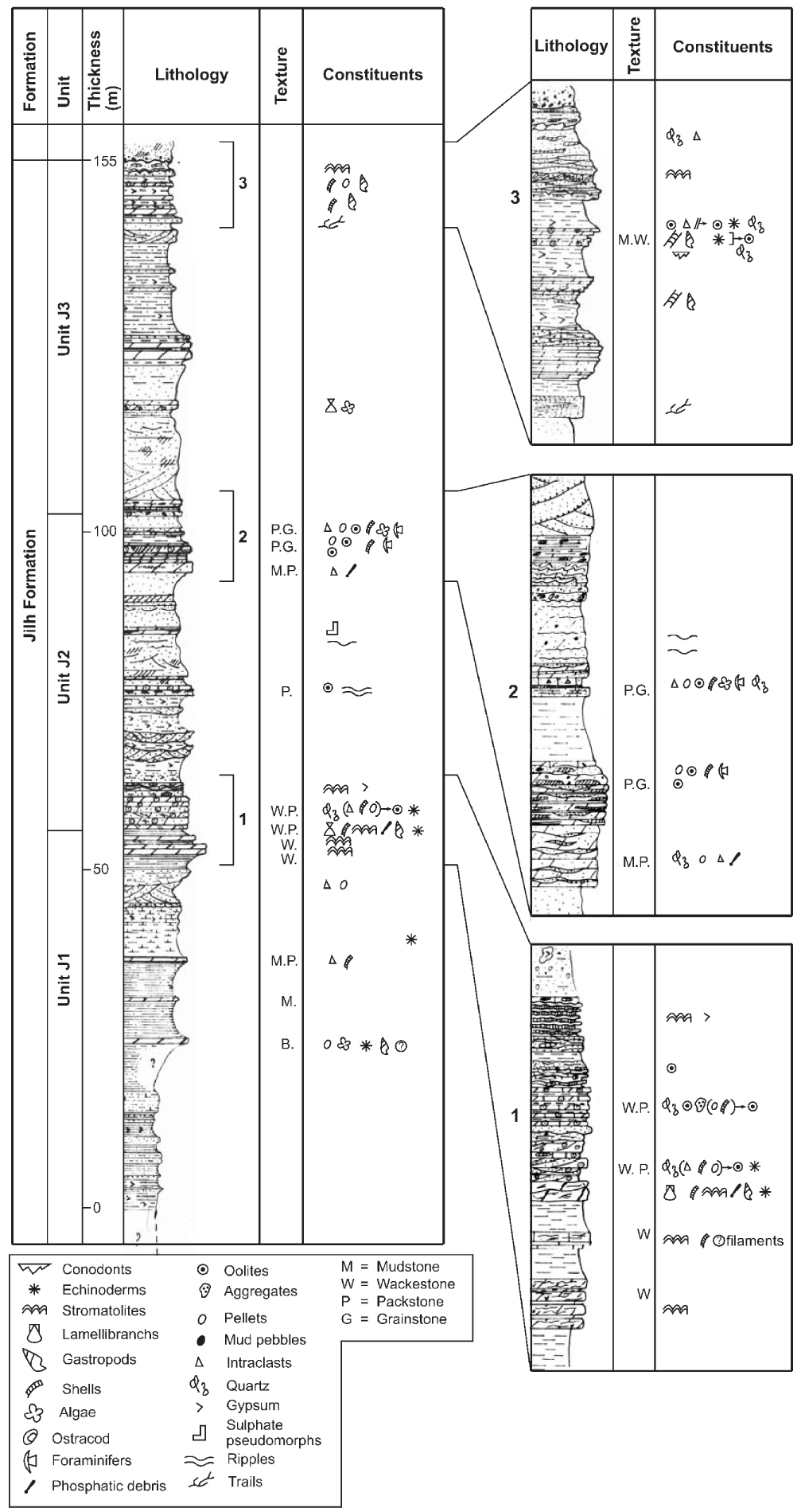
- Fluvial sandstone is at the base of the sequence, followed by brackish claystone–siltstone and capped by the tidal carbonate;
- Deltaic-estuarine sandstone is deposited partly in place of the brackish claystone–siltstone and develops southward as a wedge in the Unit J3 at Jabal al Arid (23°38′N) centred on an alluvial valley while bays and algal mats dominate northward at Khashm Dolqan (24°15′N);
- Tidal sandstone overlies the brackish claystone–siltstone, and is capped by the tidal carbonate. It is particularly present in the Unit J2, and well illustrated by the section at Khashm al Midiya’ah (24°27′N). The tidal flat deposits generally end with salt marsh or laminated sabkha sediments, which form the cap to the depositional sequence.
The Khabra Halwah Section thus particularly well illustrates the alternation between phases favouring alluvial deposits and phases leading to the reworking of such deposits by the sea (Figure 8).
4.3. Interpretation of transgression–regression (system tracts geometry)
On the basis of the analysis summarized above, we depict at larger scale the T–R sequences that characterise this formation. The ages of these sequences are discussed in Section 5. A fairly clear understanding of the processes is given by mapping several key features along a N–S transect, as follows.
Ferruginous (Fe) oolites generally have a quartz nucleus, and are likely to be chloritic oolites diagenetically altered by weathering in outcrop (Figure 4). They are equivalent to, or associated with, the formation of glauconite when chemical processes dominate the sedimentation processes, and delineate condensed intervals. Also, a thin ledge of coarse-grained quartz-rich sandstone (sometimes with gravel) may predate the Fe-oolite horizon. The thin ledge horizon is usually very continuous, as generally observed for this type of surface, and forms cuestas that can be easily correlated. The Fe-oolite horizons are significant as they typically mark the maximum rates of transgression and are associated with carbonate beds which contain age-diagnostic faunas. One in particular marks the top of the second major transgressive sequence taken as J2–J3 boundary above the main clastic event.
The distribution of carbonates in the Jilh Formation along a N–S transect (Figure 9) is represented according to two environments: most of them correspond to intertidal flats; coming from the north (as viewed in outcrop), more marine influences identify the maximum flooding intervals. This transect demonstrates a more carbonate-rich and more marine sedimentation north of 25°N, and five marine pulses, which can be grouped into three major flooding intervals, the main one reaching as far south as at least 23°N. The sedimentary wedges depict a progradation-like geometry, particularly visible near the upper boundary of the formation with the Minjur Sandstone.
Distribution of marine carbonates and clastics-carbonates facies of the Jilh Formation along the N–S strike of the outcrops [modified after Le Nindre et al. 1987, 1990a]. See Figure 1 for location of quadrangles.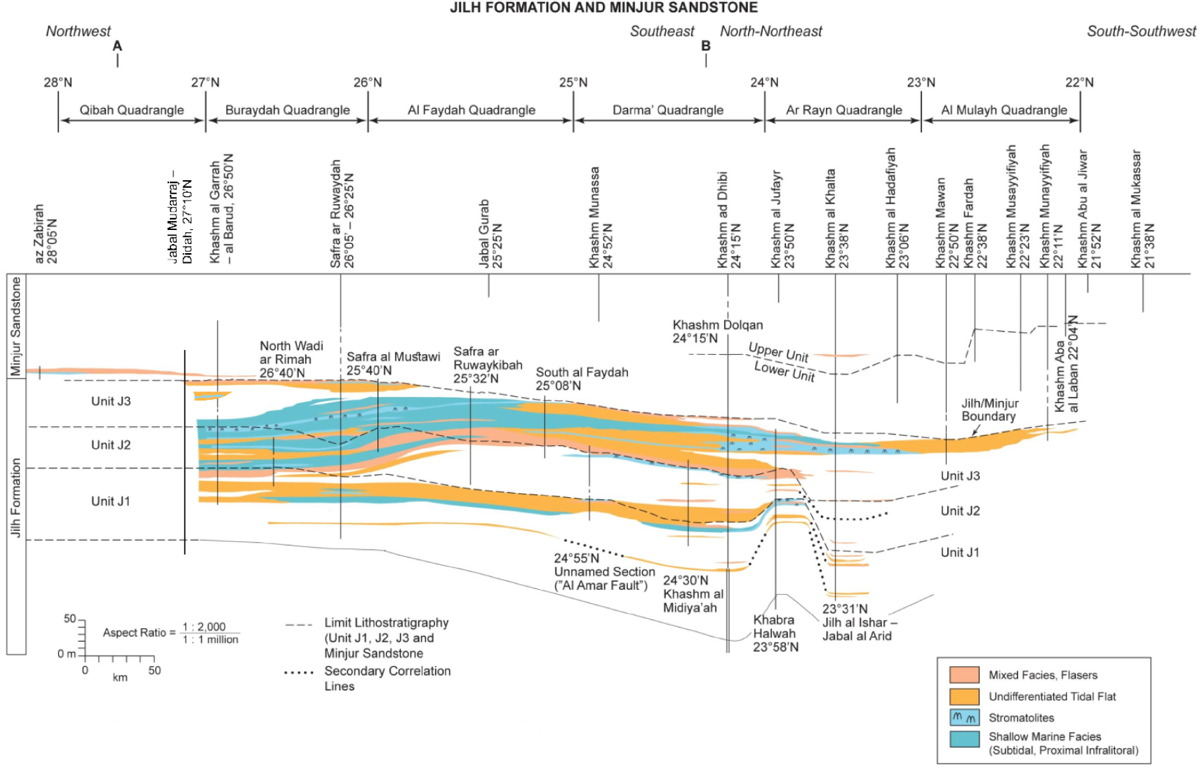
The distribution of sandstones in the formation in outcrop (Figure 10) is represented according to two environments: (1) fluvial or fluvio-deltaic sandstones which reflect the continental, prograding clastic influx; and (2) marine littoral sandstones, in general, intertidal, which reflects marine reworking of the clastics brought by the rivers and thus transgressive processes. This transects (Figure 10) demonstrates the following patterns. The coarse-grained sandstones of the Minjur Sandstone overlie the top of the Jilh Formation with the most typical facies including a basal lag with plants, silicified wood or pieces of silicified tree trunks.
Distribution of sandy facies of the Jilh Formation along the N–S strike of the outcrops [modified after Le Nindre et al. 1987, 1990a]. See Figure 1 for location of quadrangles.
Sandstone becomes more abundant between 23°N and 26°N, and especially between 23°N and 25°N. Fluvial-deltaic sandstones are distributed either in small coastal river channels or as the deltaic wedge observed at Jabal al Arid near 23°30′N. Correlations show that this body appears abruptly in lateral correspondence with thinner tidal flat deposits; the same corridor was later used by the main stream of the Minjur Sandstone. This observation is interpreted as due to a subsiding area, likely related to a NE-trending fault bounding the northern bank of the valley and superimposed on a Permian paleohigh [Le Nindre et al. 2003; Issautier et al. 2012a].
The tidal sandstones accompanying the transgressive trends concluded by the carbonates, occur particularly in the sandstones of Unit J2 between 24°N and 26°N. In detail, the sandstones of this unit show that within the overall transgressive process, higher frequency prograding and retrograding stages of the coastal domain are manifested [Le Nindre et al. 1990a, p. 206–210].
To summarize this aspect of the sedimentation, sandstones represent various trends, more generally fining-upward transgressive, and intertidal tracts, although some coarsening-upward prograding bodies were described in Unit J2. Carbonates represent the most transgressive intervals; they can be capped by short pre-evaporitic and algal supratidal sediments, as well as by salt marshes and paleosols representing reduced regressive tracts.
5. Paleontology, and age interpretation
Systematic sampling along the outcrops was performed during the BRGM/DMMR mapping program for petrographic and biostratigraphic analysis. Samples have provided a fairly varied fauna, and locally, palynoflora. In particular, ten sections (A to J) in the Jilh Formation and base of the Minjur Sandstone measured between latitudes 23°33′N and 28°01′N (Table 1; Figure 11) have yielded rich conodont faunas. These faunas, studied by Vrielynck [Vrielynck et al. 1986] and Krystyn (this study) are specifically described here for the precise results that they brought to age interpretation of the Jilh formation. Other intermediate locations have yielded biostratigraphic results that complement this understanding.
List of lithostratigraphic sections having yielded age-decisive fossils
| Section name | Quadrangle | Scale | Coordinates bottom | Coordinates top | Survey date | Authors | Letter |
|---|---|---|---|---|---|---|---|
| Az Zabirah | Turubah—28F | 1:499 | 28°05′N–43°27′E | 28°05′–43°28′E | 02/82 | D. Vaslet, A. Berthiaux | J |
| Jabal Mudarraj—Didah | Qibah—27G | 1:500 | 27°10′N–43°44′E | 27°09′N–44°02′E | 11/91 | Y. M. Le Nindre, C. Robelin, D. Janjou, J. Gouyet | I |
| Khashm al Garrah—Al Barud | Buraydah—26G | 1:500 | 26°47′N–43°58′E | 26°57′N–44°13′E | 12/82–02/83 | P. Le Strat, D. Vaslet, J. Manivit, A. Berthiaux | H |
| Safra ar Ruwaydah | Buraydah—26G | 1:500 | 26°05′N–44°20′E | 26°25′N–44°23′E | 02/83 | P. Le Strat, J. Manivit, D. Vaslet, A. Berthiaux | G |
| Safra al Mustawi | Al Faydah—25G | 1:500 | 25°40′N–44°32′E | 25°50′N–44°40′E | 03/82–11/82 | Y. M. Le Nindre, P. Le Strat, D. Vaslet, J. Manivit, A. Berthiaux | F |
| Safra ar Ruwaykibah—Jabal Ghurab | Al Faydah—25G | 1:500 | 25°32′N–44°43′E | 25°25′N–45°00′E | 03/82–11/82 | Y. M. Le Nindre, P. Le Strat, D. Vaslet, J. Manivit, A. Berthiaux | E |
| Khashm Midiya’ah | Darmā—24H | 1:500 | 24°27′N–45°28′E | 24°43′N–45°29′E | 02/82 | Y. M. Le Nindre, D. Giot, J. Manivit, J. M. Brosse | D |
| Khashm Dolqan∗ | Darmā—24H | 1:500 | 24°13′N–45°37′E | 24°12′N–46°05′E | 12/81 | Y. M. Le Nindre, J. Manivit, D. Vaslet, J. M. Brosse, C. Cavelier | C |
| SHD1 stratigraphic borehole | Darmā—24H | 1:500 | 24°13′40′′N–45°37′30′′E | 08/81 | J. Manivit, D. Vaslet | C | |
| Khabra Halwah | Wādı̄ Ar Rayn—23H | 1:500 | 23°58′N–44°49′E | 23°59′N–46°10′E | 10/80 | Y. M. Le Nindre, D. Vaslet, J. M. Brosse, J. Manivit | B |
| Jilh al ’Ishar—Jabal al Arid | Wādı̄ Ar Rayn—23H | 1:500 | 23°31′N–46°00′E | 23°36′N–46°13′E | 10/80 | Y. M. Le Nindre, D. Vaslet, J. Manivit, J. M. Brosse | A |
∗Reference section.
Location of the sections and samples having yielded age-decisive fossils along a N–S transect. Base Tuvalian, is subject to vertical adjustment. For name and location see Table 1 above. The apparent diachroneity of the J2–J3 boundaries is discussed below in Section 5.4.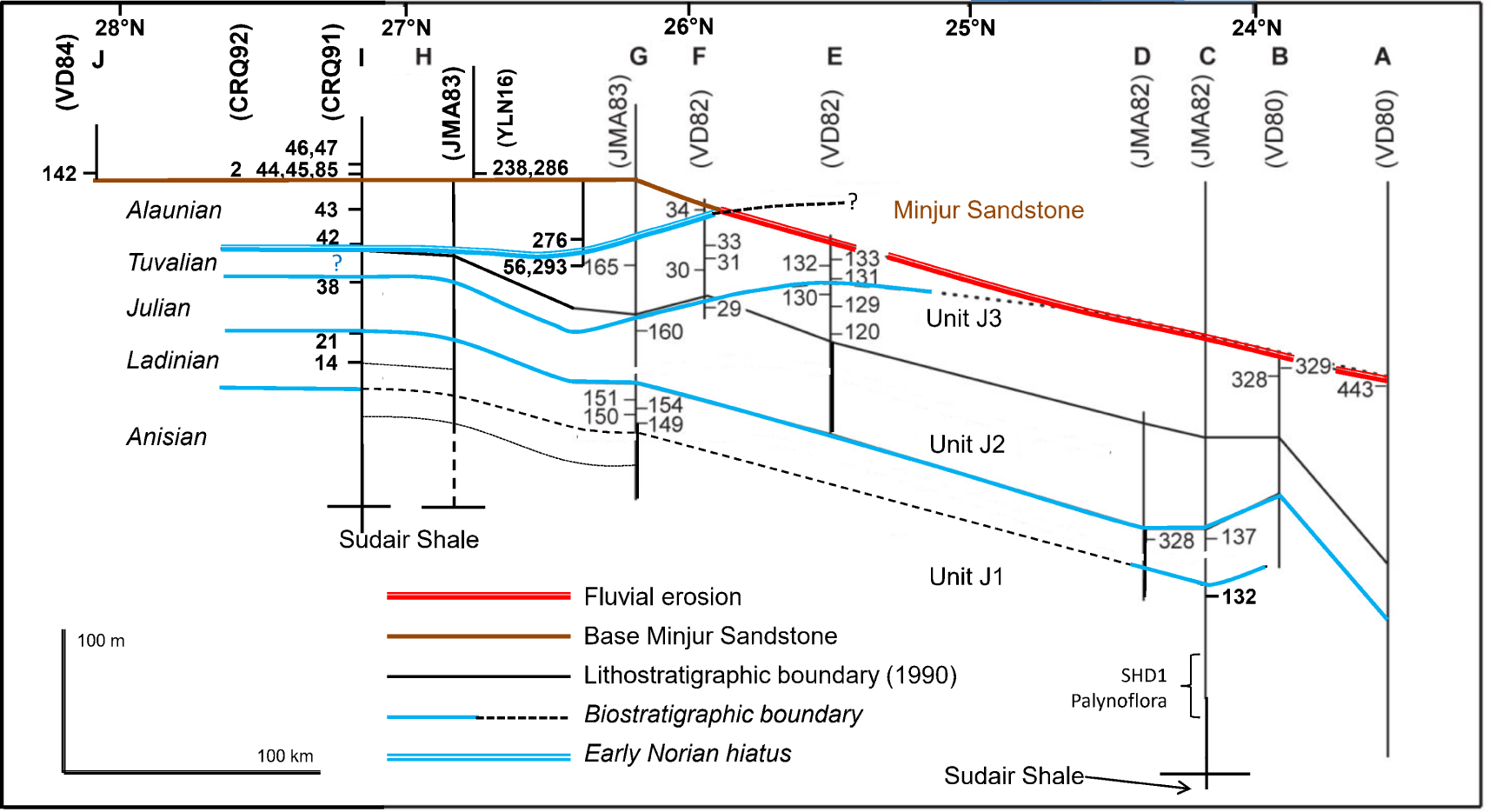
The taxonomy of conodonts used in this new study follows Chen et al. [2016] for the Ladinian, Orchard [2014] for the Carnian, and Orchard [2018], for the Norian. Here specifically, Paragondolella polygnathiformis (Budurov and Stefanov), was replaced by Quadralella polygnathiformis, Metapolygnatus aff. auriformis (Kovacs) by Quadralella aff. auriformis and Carnepigondolella carpathica (Mock) by Quadralella carpathica. The conodonts age calibrations are from the authors cited (e.g., Chen et al., Kilic et al., Orchard, Vrielynck, Mazza et al., Krystyn), principally in Section 5.3. Two ammonoid faunas were also described in the J3 upper unit near Ash Shimasiyah–Ar Rubayiyah (∼26°22′N) which corroborate conodont age assignments. Compared to Le Nindre et al. [1987, 1990a], new insight is provided in this study by the conodont fauna from the Qibah Quadrangle, and by the examination of other specimens of the ammonoid fauna from the Buraydah Quadrangle. The samples are located referring to units and subunits (e.g., J1(2)) of the concerned section in 1990 nomenclature as on the logs (Supplementary Section A, and Figure 11).
5.1. Data from the reference section
As already mentioned in section “Lithostratigraphy”, the reference section for the Jilh Formation is located at Khashm Dolqan (Figure 1 and Section C, 24°15′N Figure 10) near the original type section, and is composed of the outcropping portion completed by 79 m of series from the SHD-1 well stratigraphic core drill for the lower portion (Figure 3). The portion from J1(2) to J1(4) in the SHD-1 well has yielded a palynoflora which characterizes the Anisian, especially in J1(4) with Densoisporites nejburgii (Schulze) Balme, Alisporites cf. opii Dauguerty, Camerosporites cf. pseudoverrucatus Scheuring, and more specifically Platysaccus cf. queenslandii De Jersey. The fossils in the reference section occur in the upper part of Unit J1 (J1(5–6) and J1(8)) (Figure 11 and Supplementary Section A, Plate A.3) and comprise bivalves, conodonts, bryozoans, foraminifers and ichthyoliths. The bivalves identified as Myophoria goldfussi, (JMA82-132) are indicative of the Anisian. The Ladinian conodont Pseudofurnishius murcianus Van Den Boogaard is also recognized (sample JMA82-137, J1(8), Supplementary Section C, Plate C.7). The boundary between the Anisian and the Ladinian is thus located between the two faunal beds in the upper fifth of Unit J1 (c. J1(6)–(7) boundary) at the latitude of the reference section.
5.2. Data from other sections
The results are summarized in Figure 11 and Supplementary Section A. Units and subunits refer to Figure 11 and to the lithostratigraphic sections, in Supplementary Section A.
In Section A (Jilh al “Ishar—Jabal al Arid, 23°31′N, Supplementary Section A, Plate A.4), only sample VD80-443 could be dated. It was collected from the uppermost part of Unit J3, and contains conodonts belonging to the species Quadralella polygnathiformis (Budurov and Stefanov), present throughout the Carnian (Julian and Tuvalian).
In Section B (Khabra Halwah, 23°58′N, Supplementary Section A, Plate A.3), the top of Unit J3 contains conodonts, echinoderm debris, bryozoans, and ichthyoliths. Sample VD80-328 contains Paragondolella inclinata Kovacs, and Q. polygnathiformis, an association typical of the Julian (Early Carnian). Sample VD80-329 contains Q. polygnathiformis, indicative of the Carnian without further precision.
In Section D (Khashm Midiya’ah, 24°27′N, Supplementary Section A, Plate A.3) where the top of Unit J1 and all of Unit J2 are exposed, only Sample JMA82-328 collected at the top of the Unit J1 is fossiliferous. It contains the conodonts Budurovignathus truempyi (Hirsch) and B. cf. mungoensis (Diebel), an association indicative of the Late Ladinian.
In relation to the evolution of paleoenvironments described above, the outcrops located northwest of 25°N contain more fossils than those to the southeast.
In Section E (Safra ar Ruwaykibah—Jabal Gurab, 25°32′N, Supplementary Section A, Plate A.2) where the totality of Units J2 and J3 is exposed, Unit J2 proved to be barren, whereas many conodonts associated with foraminifers and ichthyoliths are encountered in Unit J3. Sample VD82-120 collected at the base of Unit J3 contains Mazzaella carnica (Krystyn), characteristic of the Julian. Sample VD82-129 collected from the middle of the unit contains Quadaralella aff. auriformis (Kovacs) and Q. polygnathiformis. This is a Carnian association, and the presence of Q. aff. auriformis indicates the Julian. The samples collected from the upper part of Unit J3 (samples VD82-130-133) are monospecific, containing only Q. polygnathiformis, which persists throughout the Carnian, with the exception of the very uppermost part.
In Section F (Safra al Mustawi, 25°40′N, Supplementary Section A, Plate A.2), where the top of Unit J2, all of Unit J3, and the base of the Minjur Sandstone are exposed, the sample collected from J2 (VD82-29) contains M. carnica, typical of the Julian. The samples collected from the middle part of Unit J3 contain foraminifers, ostracods, bryozoans, and conodonts. The conodonts belong to the Carnian species Q. polygnathiformis, associated in sample VD82-33 with Q. carpathica (Mock), known exclusively from the Tuvalian (Late Carnian). A Tuvalian age can thus be assigned to the middle part of Unit J3. The uppermost beds of Unit J3 (sample VD82-34) contain Epigondolella abneptis (Huckriede), known in the Norian, together with some ichthyoliths.
In Section G (Safra ar Ruwaydah, 26°05′N, Supplementary Section A, Plate A.2) where the whole of the Jilh Formation, except for the very bottom, and the Minjur Sandstone are exposed, the upper part of Unit J1 contains echinoderm debris, ostracods, and conodonts. Samples JMA83-149 and JMA83-150 contain B. truempyi, and samples JMA83-151 and JMA83-154 contain P. murcianus (Supplementary Section C, Plate C.7). Both these species are indicative of the Ladinian. Sample JMA83-160 from the upper third of Unit J2 contains Q. polygnathiformis and M. carnica, an association typical of the Julian. The middle part of Unit J3 (sample JMA83-165) contains Q. polygnathiformis associated with echinoderms debris and bryozoans indicating a Carnian age.
About 30 km northward, near Rubay’iyah (26°28′N) the formation has yielded two faunas of ammonoids (Supplementary Section C, Plates C.1 to C.6):
- The top of the lithological Unit J3(3) is marked by a weathered dolomite containing a fauna of Tropitids (JMA83-293) with a “Clydonites-like” form (E. T. Tozer written communication, 1985), similar to the species cited by Powers et al. [1966]. E. T. Tozer suggested a Carnian age for this fauna. Similarly, in November 2016 in the same area (Ash Shimasiyah, 26°21′37.00′′N, 44°20′10.00′′E), D. Vaslet and Y. M. Le Nindre collected a Tropitid ammonoid (YLN16-056) identified as ?Discotropites of Late Carnian age by H. Bucher (written communication, 2017) which is reinterpreted here as ?Pleurotropites sp. by LK.
- 18 m above this horizon, within the unit J3(4), a yellow carbonate horizon, continuous and well exposed in outcrop, yielded another monospecific fauna; several tens of specimens were collected (JMA83-276), identified as “Neotibetites sp.” by E. T. Tozer who assigned them to a Mid-Norian and rather late Mid-Norian age (written communication, 1985). This concentration reflects a local thanatocoenosis.
- Other specimens of the same samples as above were examined by LK and J. Marcoux, and reported with the following taxa and ages (new unpublished results):
- JMA 83-293: Pleurotropites sp.ind., Sirenites sp., Shastites sp.; age: Tuvalian Tuvalian 1, Tropites dilleri zone, eventually Tuvalian 2/I)
- JMA 83-276: Anatibetites kelvini Mojs., Paratibetites cf. geikiei Mojs., ?Metacarnites sp.; age: Middle Norian (Alaunian); if the questionable Metacarnites is true, then Alaunian 1.
In Section H (Khashm al Garrah—al Barud 26°47′–26°57′N,—also named Safra al Agyah, (Supplementary Section A, Plate A.1) ranging from the middle part of Unit J1 up to the lower layers of the Minjur Sandstone, numerous conodonts belonging to the species E. abneptis and some ichthyoliths are found in sample JMA83-286 just above a remarkable accumulation of tree trunks (JMA83-238) taken as the base of the Minjur Sandstone; the conodont indicates a Norian age. In the same section, marker foraminifera were identified by D. Vachard (written communication, 1984) at the top of Unit J1, the sample JMA83-60 contains among the bioclasts a few foraminifera: Globivalvulina sp., “Nodosaria” sp., and Glomospira sp. (“cf. Meandrospira”) assigned to a Permian association. In fact, the petrographic study by Le Nindre shows that they are reworked constituents related to a transgressive surface (mid-Julian marker bed, see “Depositional History and Sequence Analysis”), and that this fauna originates from the Khuff Formation. Near the top of Unit J3, just underneath the base of the Minjur Sandstone dated Norian by conodonts, the sample JMA83-75 yielded Involutina eomesozoica (Oberhauser), which is a marker of the Ladinian–Carnian. Due to the fact that the petrographic study reveals, here again, a bed of quartzarenite containing obviously reworked carbonate constituents, and that a Norian age was retained for the coeval lateral beds, it is very likely that the foraminifer was reworked from the substratum into the Norian sandstone, supporting interpretation of a Carnian–Norian unconformity.
In Section I (Jabal Mudarraj—Didah, 27°10′N, Supplementary Section A, Plate A.1, and Supplementary Section B, Plate B.1 and Supplementary Section C, Plates C.8 to C.10), newly studied conodonts were found throughout the Jilh Formation. In the upper part of the Unit J1, samples from the dolomite forming the first main cuesta provided a (Late?) Ladinian age: CRQ91-14 with Pseudofurnishius shagami (Benjamin and Cheepstow-Lusti), containing also vertebrae, and CRQ91-21 with P. shagami and P. cf- shagami transitional to Budurovignathus truempyi (Hirsch). In the Middle part of the Unit J2, the sample CRQ91-38 yielded interesting though poor material of Mazzaella carnica, indicating late Early Carnian. Various horizons of the J3 Unit provided conodonts. Of six studied samples, four (CRQ91-42, 43, 44, 45) yielded platform conodonts (Ancyrogondolella) of basal Middle Norian age (Alaunian 1) and the other 2 were barren (CQR 91-81, 92-3). All of the productive samples yielded the same 2 species: Ancyrogondolella praeslovakensis (Kozur, Masset and Moix) and a new Ancyrogondolella, here called as A. ex gr. uniformis (Orchard). Epigodolella abneptis is comparably rare and restricted to the highest sample CRQ91-45. A. praeslovakensis has been described by Moix et al. [2007] from Middle Norian limestones within the Mersin melange, Turkey, where it co-occurs with Alaunian 1 ammonoids (Cyrtopleurites, collected and determined by LK). Also, the new species, Ancyrogondolella ex gr. uniformis, is found in many Alaunian 1 ammonoid dated Hallstatt sections between Austria and Timor (unpubl. data, LK).
The exact position of CR91-42 in section (between samples 41 and 43) is not recorded in the field book. But, from sample description, and by comparison with a similar horizon in Section H, it very likely originates from a bioclastic–oolitic grainstone beneath the khaki shale interval, just on top of sample 41, at the base of Unit J3. True Epigondolella abneptis occurs in sample CRQ91-45. Samples CRQ91-46 and 47 were taken from holes in black silty claystone of sabkha deposits, about 6–7 m above the samples 44 and 45 and 2 m above silicified wood occurrence. Palynology indicates a Norian age based on association of Circumpolles, Camerosporites tenuis, Ovalipollis pseudoalatus, and Spiritisporites spirabilis (internal technical note Danielle Fauconnier 92-GEO-GSM 040, 1992). This silicified wood is coeval with the tree trunks found in Al Barud, a few kilometers southward [Manivit et al. 1986] and with the flora from Hunaydhel (Hunayzil on the Buraydah Geological Map) recently studied by El-Atfy et al. [2022].
The Alaunian age of the Jilh–Minjur boundary was confirmed in two other locations: from another similar section in Unit J3, the sample CRQ91-85, in a situation comparable to CRQ91-44, indicates again Middle Norian (Alaunian 1). From a portion of section in Aba ad Dud, the sample CRQ92-2 taken from a Fe-oolite grainstone with oncolites in a transgressive horizon yielded the same conodont fauna of Alaunian 1 age.
In Section J (Az Zabirah, 28°05′N, Supplementary Section A, Plate A.1) at the base of the Minjur Sandstone, many conodonts of the species E. abneptis of Norian age were found in Sample VD84-142.
5.3. Discussion of age interpretations
5.3.1. Anisian
The Anisian was dated by Myophoria goldfussi—although the age range of this bivalve may be disputed—and by palynology in the reference section.
Vickers-Rich et al. [1999] have studied a rich fauna of vertebrates from the Ar Rubayiyah–Ash Shimasiyah area (26°25N′, 44°14′E)–(26°22′N, 44°16′E) already cited above in section “Vertical Evolution of Depositional Environments”. It includes hybodontiform sharks, actinopterygians, and sauropterygian reptiles such as a pachypleurosaur, Simosaurus, nothosaurs and cyamodontoid placodonts. This fauna compares well with other Middle Triassic faunas from the Germanic and Alpine Triassic, and from the northern Gondwanan shelf, in particular with the fauna from Makhtesh Ramon, Negev.
Similar horizons were described in several sections by BRGM, in particular those that we mentioned at Khashm Dolqan (Figure 2, Darma quadrangle) and Al Mudarraj-Didah (Supplementary Section B, Plate B.1, Qibah quadrangle), and by SGS at Ar Rubay’iyah within the Unit J1 and in particular near the top of this unit (Plate B.2). By comparison of the fossils with those from other localities, the age best estimated by Vickers-Rich would range from Late Anisian to Ladinian, close to the Anisian–Ladinian boundary. This estimate matches well the stratigraphy established herein by the other indicators (palynomorphs, bivalves, conodonts).
Kear et al. [2010a, b] conducted a new field survey near Ar Rubay’iyah, but also on the Reference Section of Khashm Dolqan which yielded large quantities of vertebrate fossils ranging from Upper Anisian to lowermost Carnian in age. These finds prompt a revision of the existing faunal list of sharks, fishes and marine reptiles, in particular the discovery of the lungfish, Ceratodus sp., [Kear et al. 2010b]. The remains thus comprise sauropterygian marine reptiles (Psephosauriscus sp., Nothosaurus cf. tchernovi, Nothosaurus cf. giganteus, Simosaurus sp.), a lungfish (Ceratodus sp.), hybodontiform sharks (Hybodus sp.) and saurichthyform actinopterygians (Saurichthys sp.). For Kear et al. [2010b, p. 1]: “palaeobiogeographical assessment reinforces Tethyan affinities for the assemblage and reflects the close proximity of the Arabian region to the “Sephardic Realm”, a compositionally distinct circum-Mediterranean faunal province characterized by hypersaline “Muschelkalk facies”. This paleobiogeographic interpretation matches a similar conclusion by Vrielynck based on Ladinian conodonts (see in Part II, Section “paleogeography”).
5.3.2. Ladinian
The Ladinian is well constrained from south to north by the conodonts Pseudofurnishius murcianus Van Den Boogaard (Supplementary Section C, Plate C.7), and Budurovignathus truempyi (Hirsch) at Khashm Dolqan (24°15′N), Khashm Midiya’ah (24°27′N) and Safra ar Ruwaydah (26°05′N). In the section at Khashm Midiya’ah the association B. truempyi and B. cf. mungoensis (Diebel) is indicative of the Late Ladinian [Hornung 2006; Vrielynck 1984; Vrielynck et al. 1986], former Protrachyceras archelaus zone, Longobardian 2. In the south of the Qibah Quadrangle, the laterally correlated horizon (first main cuesta) is also of Ladinian age as confirmed by the recovery of Pseudofurnishius shagami [Benjamini and Chepstow-Lusty 1986], and P. cf. shagami transitional to Budurovignathus truempyi (CRQ91-14 and 21). Note that this conodont association is slightly different in this northern area than more south, in other sections. This point could be explained in two different ways:
- Age-based difference: from Plasencia et al. [2015], P. shagami would be restricted to Fassanian (Early Ladinian), whereas southward, in coeval beds P. murcianus, although known possibly since Fassanian, proliferates in the uppermost Ladinian horizons in our sections and thus very likely in the Longobardian, in agreement with Plasencia et al. [2015, their Figure 8]. In this option, a satisfactory correlation with ammonoid zonation would appear for P. shagami, B. truempyi and B. mungoensis with Curionii, Gredleri, and former “Archelaus” zones (cf. Longobardicus), respectively. This hypothesis would imply a diachronic sheet-transgression on a ramp (coastal onlap), based on the occurrence of older (Fassanian) species in the north, and of younger (Longobardian) species only, south of Lat. 26°30′N (Fassanian hiatus). However, one remaining question is why the Longobardian would not be recognized in the north?
- Environment-based difference: one of the authors (LK) prefers an effect of the paleoenvironment on species distribution, with Budurovignathus associated to flooding events, or deeper settings, and Pseudofurnishius associated to the regressive phase, or shallower setting. This hypothesis is supported by the vertical distribution of the conodonts where the two are present, and by restriction of Budurovignathus to a more marine area (lat. 24°27′N–26°21′N).
Fish debris are common in two separate horizons that can be identified at various locations along the full extent of the outcrop. As we have seen above in the previous paragraphs [Vickers-Rich et al. 1999], the age of the upper beds of fish and reptiles remains found in several sections is compatible with the Ladinian age provided by conodonts.
5.3.3. Julian
A reasonable correlation is found at the base of the Julian carbonates with M. carnica (JMA83-160, VD82-29, VD82-120), in the condensed horizon with Fe-oolites, supporting its use for further correlations. A late Early Carnian age was confirmed in the south of the Qibah quadrangle by M. carnica/baloghi (CRQ91-38). Its presence is very likely related to a significant flooding event on the Arabian shallow shelf. In Hornung et al. [2007], the “auriformis” abundance zone (AZ) and “carnicus” interval zone are shown after Gallet et al. [1994, their Figure 2] within the late early Julian (Julian 1/II and base Julian 2). According to Kovacs [1977] and to the most recent paper by Kiliç et al. [2015], the Mazzaella lineage derives from Quadralella auriformis (Kovacs). Q. aff. auriformis (Kovacs) is present in sample VD82-129, just adjacent to VD82-120.
The Julian age on top of the formation at Khabra Halwah (23°58′N) is provided by Paragondolella inclinata (VD80-328). This species, which can be present in association with B. mungoensis since the Late Ladinian/Longobardian [Hornung 2006], is found here as a Ladinian relict species which survives up to the extinction event at the Early/Late Carnian boundary [Rigo et al. 2005].
5.3.4. Tuvalian
The populations of Q. polygnathiformis, though of large age range, are more frequent in the upper Jilh, where they would indicate either Julian or Tuvalian when in association with specific markers (e.g., P. inclinata for the Julian and Q. carpathica for the Tuvalian). Its abundance zone is shown in Tuvalian 1 and Tuvalian 2/I by Hornung et al. [2007, after Gallet et al. 1994].
Q. carpathica (VD82-33) indicates an early to middle Tuvalian age. Similar to M. carnica, derived from Quadralella through a late Julian lineage, Q. carpathica derives from Q. polygnathiformis through a Tuvalian lineage [Orchard 2014]. Following Gallet et al. [1994, in Hornung et al. 2007] the “carpathicus” abundance zone (AZ) is shown in the Tuvalian 2/II though the species may appear already in the early Tuvalian according to Mazza et al. [2012]. The specimens of tropitids ammonoids (JMA83-293) observed by J. Marcoux and L. Krystyn would be rather Tuvalian 1, eventually up to 2/I. In any case, this Tuvalian age is consistent with the specimens submitted to E. T. Tozer and with the last sample recently submitted to H. Bucher (YLN16-056) from the same horizon within the Buraydah Quadrangle. The reference section of the Qibah Quadrangle did not provide evidence of Tuvalian sediments, and thus, Tuvalian may have been partially absent or eroded and may be part of the Early Norian hiatus.
5.3.5. Norian
The Norian was first recognized in the Unit J3 of the Jilh Formation and in the Lower Minjur by Epigondolella abneptis (Huckriede), originally identified in the samples by Vrielynck [1984]. This species was regarded by previous authors as ranging throughout most of the Norian as well as the late Carnian.
The older forms assigned to this species were later subdivided into several subspecies by Orchard [1983], all ranging in the Lacian (Early Norian, his Figure 10); but this age conflicts with the age given by the co-occurring Middle Norian Tibetitidae.
Recently, Orchard [2018] assigned the Lower Norian “Epigondolellas” to the genus Ancyrogondolella, whereas Krystyn [2008] identified Epigondolella abneptis at its type locality as a distinct Middle Norian form.
This uncertainty was resolved by the new study on the Qibah conodonts. Five samples, from the reference section (CRQ 91-42, 43, 44, 45), and from coeval outcrops (CRQ 91-85 and CRQ92-2) yielded the same species of basal Middle Norian age (Alaunian 1): Ancyrogondolella praeslovakensis (Kozur, Masset and Moix) and another Ancyrogondolella of the A. uniformis group. A. praeslovakensis and the new Ancyrogondolella are found in many Alaunian 1 ammonoid-dated sections cited above (see Section 5.2, Section I).
Thus, both conodonts and ammonoids converge towards an early Alaunian age which implies a hiatus of more than 10 Ma, and likely greater (11–14 Ma) in the case of erosion of the Tuvalian, as in Qibah area, where it has not been found. North of 25°30′N, continuity of facies and of environment, and lack of coarse-grained clastics which would reflect an obvious discontinuity or a sequence boundary, make causes and mechanisms of this hiatus hypothetical. In this case we would assume a transgressive erosional wedge (marine onlap). We have already formulated this hypothesis [Le Nindre et al. 1987, 1990a], but on a different age basis.
At the upper contact with or at the base of the Minjur Sandstone, a good correlation is found by E. abneptis in several sections, from north to south: Az Zabirah (VD84-142), Jabal Mudarraj-Didah (CRQ91-45), Al Barud (JMA83-286), and Safra al Mustawi (VD82-34). One of the authors (LK), does not exclude that this horizon might be a bit younger in the Alaunian [according to the age range of E. abneptis, up to Alaunian 3 in Krystyn et al. 2009].
5.4. Diachronous lithostratigraphic boundaries: erosional hiatuses
Previous studies of the conodonts and ammonoids (Jacques Manivit, Bruno Vrielynck and Eward T. Tozer in Le Nindre et al. [1987, 1990a]) had demonstrated that the historical Units J2 and especially J3 as defined in the south and in the north are diachronous (Figure 11). Increasingly, various publications document this diachroneity at a plate-wide scale. In particular, Davies and Simmons [2018], Davies et al. [2019] attempted to demonstrate this for the Sudair Shale in their Figure 5 while also showing the lower part of the Jilh Formation.
For explaining this diachroneity north of Lat. 25°30′N, Y. M. Le Nindre had invoked an erosional wedge, tentatively related to a transgressive Tuvalian surface. In fact, this new study, providing complementary and more accurate ages within this area demonstrates (Figure 12) that the main causes of this apparent diachroneity is a Carnian–Alaunian hiatus with a time gap greater than 10 Ma due to:
Conceptual sketch of the Jilh—Minjur systems in outcrop. Summary of lithological units, paleo-environments, ages, unconformities and flooding sequences including update from Issautier et al. [2019]. The Early Ladinian was not recognized south of Lat. 27°N. Correlations with regional maximum floodings (Tr), and CPE, are discussed in Part II.
- A fluvial erosion by the Minjur sandstone; south of Lat 25°30′N, which incised the Jilh tidal deposits [see also Issautier et al. 2019].
- A marine Tuvalian-Early Norian hiatus of more than 10 Ma (11–14 Ma?), north of Lat. 25°30′, which can be still interpreted as a Norian transgressive erosional wedge.
The Early Norian disconformity or unconformity is thus more than a simple obliquity of time lines on stratigraphy. A dynamic reconstruction of the depositional structures by time slices in Part II better demonstrates all geometric relationships.
6. Conclusion on Part I: Jilh formation chronostratigraphy of the depositional units
- The Anisian to Carnian Jilh Formation crops out extensively in Central Saudi Arabia (latitudes 22°N to 28°N). It was previously mapped and analysed in 1990–1991 by BRGM geologists, who described predominantly mixed siliciclastic lithologies with subordinate carbonates and evaporites representing non-marine to offshore environments. The current study builds on this previous work.
- Stratigraphic understanding of the Jilh Formation has been improved by analyses of new conodont finds and a re-evaluation of existing ammonoid data.
- There is a pre-existing three-fold scheme of lithostratigraphic units for the Jilh Formation based on the field mapping of cuestas but the new biostratigraphic data confirms that these landforms are discontinuous and the units diachronous along the full length of the outcrop and should not be used as the basis for regional correlation. This raises the issue of the Jilh–Minjur boundary, addressed in Part II.
- Four large scale transgressive–regressive cycles can be identified in the Jilh Formation. An Anisian flooding event is defined by tidal flat deposits. Ladinian, Julian (Early Carnian) and Tuvalian (Late Carnian) flooding events all culminated in fossiliferous marine carbonates. The age of these marine carbonates are closely defined by the new conodont and re-evaluated ammonoid data. Of these flooding events, the Julian transgression was the most regionally extensive. The Tuvalian flooding event is missing by erosion in outcrops south of latitude 24°N.
- The current study identifies a major influx of continental clastics at the end of the Ladinian, and in the early Julian, likely related to late Ladinian regression. It may have laterally equivalent evaporitic deposits. Subsequent marine transgressions reworked the deltaic sands brought by the rivers to longshore coastal sand bodies.
- Further subdivisions that are candidates for sequence boundaries in the Jilh Formation can be proposed at the base of the Julian clastics and at the base of the Late Julian transgression marked by iron oolites overlying paleosols.
- At the Khashm al Khalta section, transitional facies previously assigned to the Minjur Sandstone are now included in the Jilh Formation and cap the Julian Jilh dolomite equivalent. They are overlain by erosional channel sandstones.
- South of latitude 25°30′N, an erosional unconformity marks the boundary between the Jilh Formation and the overlying Early Norian (pars) to Early Jurassic, continental to marginal marine Minjur Sandstone, previously described by Issautier et al. [2019]. The unconformity is readily identified in southern outcrops where fluvial sandstones erosively overlie mixed marginal marine deposits of the Jilh Formation (Figure 12). It accounts for the southward erosion of the Tuvalian flooding event beneath Norian fluvial sandstones.
- North of latitude 25°30′N, ammonoids and conodont finds are reported from the upper part of the Jilh Formation and the basal part of the Minjur Sandstone. Together with previously documented dinoflagellate cyst data, these new finds identify a ⩾10 Ma hiatus covering part of the Tuvalian and the Early Norian. These observations unequivocally demonstrate that the lithostratigraphic boundary between the Jilh Formation and the Minjur Sandstone lies above the Carnian–Norian hiatus in outcrops north of 25°30′N but marks the hiatus itself in outcrops further south. The finds also confirm the presence of a Middle Norian (Alaunian) transgression that corresponds to the Rhaetogonyaulax wigginsii flooding event identified by Issautier et al. [2019] (Figure 12). The latter authors identified a second, younger flooding event associated with the dinoflagellate cyst Rhaetogonyaulax rhaetica.
- The identification of probable 3rd order transgressive–regressive cycles and a major hiatus provides a strong foundation for sequence stratigraphic analysis and regional correlations. Correlations within the outcrops of the Jilh Formation and overlying Minjur Sandstone and into the near subsurface [Issautier et al. 2019] highlight geometric and chronostratigraphic aspects of the stratigraphy (Figure 12). This discussion is continued in Part II.
Conflicts of interest
Authors have no conflict of interest to declare.
Acknowledgments
The authors thank the Deputy Ministry for Mineral Resources, Kingdom of Saudi Arabia, for his support to the Phanerozoic Cover Rock Mapping Program during which most of the field works were performed and for permission to publish (BRGM-OF-06-31). The publication of this Synthesis on the Triassic of Saudi Arabia was made possible through this Special Publication as a Tribute to Jean Dercourt under the auspices of the French Académie des Sciences. Authors are especially grateful to the editors François Baudin, Sorbonne Université, François Chabaux, Strasbourg University and Eric Calais, Ecole Normale Supérieure for their invitation, encouragement, and support. The authors have special thanks to Augustus Wilson and to Moujahed I. Al-Husseini, former Editor in Chief of GeoArabia, for their constructive comments while writing this paper. The new decisive results on conodonts from the Qibah area by Leopold Krystyn were made possible thanks to the support provided by Benoit Issautier and Olivier Serrano, BRGM. Thanks to James W. Haggart from the Geological Survey of Canada who very kindly spared his time for providing photos of the original Tozer’s collection of ammonoids in Vancouver, and to Raymond Enay, for specimens stored in the University Lyon I, we have now illustration of this key fauna. The authors are also very grateful to Nino Buhay, former graphic team of GeoArabia. We thank Mike Simmons and an anonymous reviewer whose insightful comments greatly improved the paper.
Supplementary data
Supporting information for this article is available on the journal’s website under https://doi.org/10.5802/crgeos.217 or from the author.