


 CC-BY 4.0
1. Introduction
In Africa, freshwater reserves stored in groundwater are much larger [Taylor et al. 2013; Lezzaik and Milewski 2018; Remini 2021]. This abundance masks a very large disparity in resources and serious supply difficulties for at least 25 African countries [Dos Santos et al. 2017]. In sub-Saharan Africa, only 24% of the population has access to a safe source of drinking water [ONU 2019], yet accessibility to drinking water is one of the major objectives of development projects worldwide [Cuthbert and Taylor 2019; Kouassi et al. 2019; Mahamat Nour et al. 2022].
Furthermore, Chad, located south of the Sahara, has vast regions made up of sedimentary formations, serving as the seat of continuous aquifers, and of basement formations, in which discontinuous aquifers are found [Gómez-Escalonilla et al. 2022; Schneider and Wolff 1992]. It is in the basement areas that the problem of water scarcity is most acute [Oursingbé and Tang 2011; Abdou et al. 2020]. It is in the mountainous zone of the Ouaddaï massif that this water scarcity is most often observed [Al-Djazouli et al. 2021; Djoret 1992]. This area of Precambrian and Cretaceous reactivated basement [Durand and Sebag 2015] has the lowest rate of access to drinking water in the country. About 60% of the boreholes drilled in this area are negative (boreholes with flow rates <0.5 m3/h, [PHVOB 2006]). The aquifers in these areas are discontinuous and localised in streambeds or faulted structures. Finding these aquifers is a real challenge. There are very few studies in the area to properly characterise the potential water points. Hence the purpose of this study is to contribute to the determination of favourable areas for the recharge of the basement aquifers of Biltine and its surroundings, to improve the success rate of drilling and facilitate the supply of drinking water to the population. This involves: (1) determine the parameters of characterisation of recharge (precipitation, drainage density, catchment areas, slope, soil type, land use, thickness of alluvium and alterites and fractured thickness), (2) determine the degree of infiltration and (3) make the map of potential areas of groundwater recharge.
This mapping of recharge zones could help circumscribe the surface area for potential groundwater pollution. Furthermore, this area is a potential gold and/or rare earth deposit. Mining without precautionary measures could have a negative impact on the environment in general, and on water resources in particular. So not only do we need to quantify the groundwater resources in this area, but we also need to identify areas that could be protected against the effects of the pollutants that will be used for artisanal gold mining, for example.
2. Physical setting of the environment
2.1. Location of the area
The study area is in eastern Chad, about 1000 km from N’Djamena. The study area (Biltine) lies between 20°50′ and 21°40′ east longitude, and 14°05′ and 14°55′ north latitude (Figure 1). The climate of Biltine is Sahelian. It is characterized by an average annual temperature of about 35 °C and a very low relative humidity [Soumana 2012]. The two hottest months are: May and June (with a maximum average at the turn of 39 °C). In January and December, it is cooler (the minimum average is 29 °C). The average annual rainfall in the locality is between 200 mm and 600 mm [Adey et al. 2018; Jean-Dénis 2002].
Location map of the study area.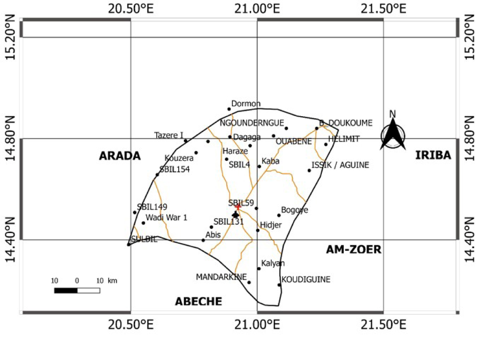
2.2. Geological and hydrogeological framework
The geological formations occupy an area of altitudes between 610 m and 1200 m [PHVOB 2006]. They consist of magmatic and metamorphic terrains [Gachet and Foreste 2005] belonging to a vast batholith of calc-alkaline granite of the Precambrian [Plote 1970] and recent sedimentary formations of the piedmont plains [Djoret 1992]. Tectonic dislocations are observed in the locality (Figure 2). The fracture zones are covered by sedimentary formations [Kusnir 1995].
Geological and tectonic map of the study area.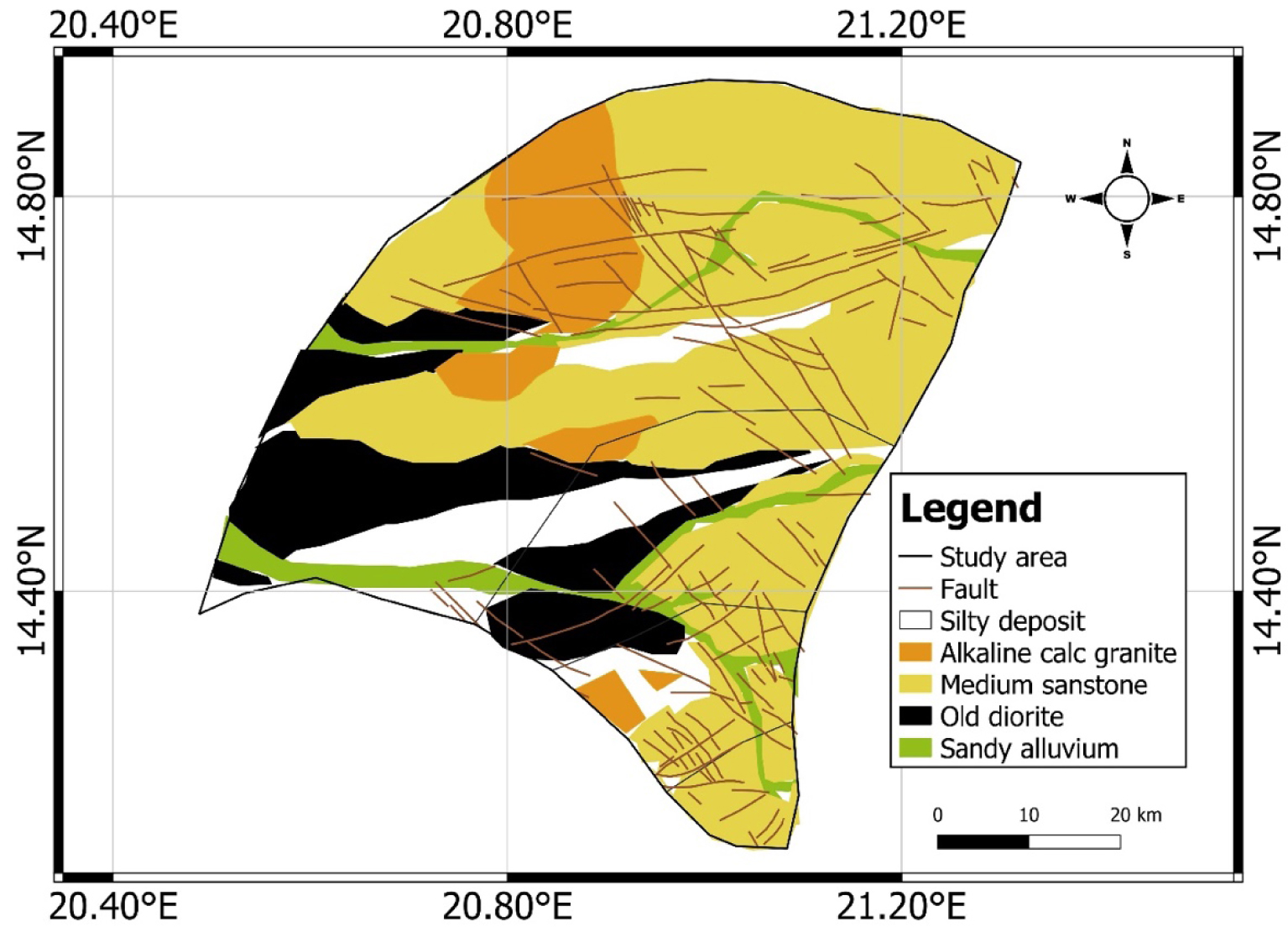
The watercourses of the locality are temporary ouadis and ponds. These temporary springs result from floods.
The aquifers in the region are divided into alluvial cover aquifers on the one hand and crystalline basement aquifers on the other [Bunzli and Haeberlin 2005; Gombert 1999]. Groundwater quality is generally good.
3. Methodology
3.1. Data
The field data collection work took place from December 27, 2020 to January 24, 2021, during the dry season. These data collected are the borehole depths, piezometric levels, geometric characteristics of the basin and the geology of the area (lithological log). These field data are complemented by existing information which are:
- Geologic and hydrogeologic maps from Schneider and Wolff [1992] and Kusnir [1995],
- 90-m resolution SRTM image and LANDSAT 8 image downloaded from the USGS website used to determine drainage patterns and vegetation index,
- Borehole hydrodynamic data Static level, flow [PHVOB 2006],
- Borehole water physicochemical data [CDIG 2020],
- Meteorological data from the Biltine station [ANAM 2020],
- Borehole and well data sheets [PHVOB 2006].
3.2. Methodology
The multi-criteria analysis is the method chosen for this work. It takes into account meteorology (precipitation), geomorphology (determination of the slope), geology (determination of alluvial and alteration thicknesses and fractured thicknesses) Almy Nadif project data, 2006, hydrology (determination of drainage density and vegetation index), hydrogeology (determination of drilled depth, flow rate, piezometric level) and pedology (type of soil). The work of this analysis begins with:
- The weighting of the criteria: it is done by determining the weights of the criteria and assigning scores according to the scale of Saaty [1977].
- Classification and standardisation: Based on the work of Youan [2008], Jourda et al. [2006], the classification of the criteria consists of grouping their values into classes to facilitate their interpretation. Classes are defined as very weak, weak, medium, strong, and very strong.
Each indicator becomes an entity with statistical values. The statistical values are saved in CSV format and then exported to QGIS where they are transformed into a vector. This step is part of the spatial analysis. It is the process of manipulating spatial information to extract new information and meaning from the original data [Bavoux 2009]. This spatial analysis is performed in QGIS 2.18 according to the interpolation steps.
For validation of this work, positive (⩾0.5 m3/h) and negative (<0.5 m3/h) boreholes are projected onto the final map.
To determine recharge areas, eight factors were studied:
3.3. Precipitation and drainage network
The average rainfall recorded in the locality is divided into three (03) levels [very low (140 mm/year), low (290 mm/year) and medium (446 mm/year)].
According to Figure 3, the amount of rainfall decreases from the south to the north. Thus, the northern locations, which receive less rainfall, have a lower recharge potential than the southern regions.
Distribution of précipitation.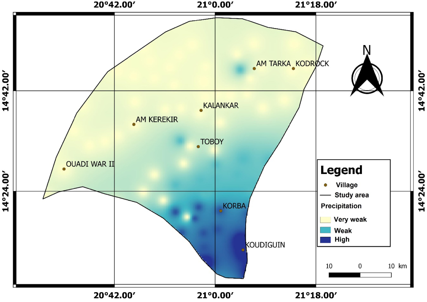
The drainage network in the study area is not very dense. The higher elevation locations to the east have a slightly higher density (between 0.49 and 0.9 km/km2) than the other parts (0.46 km/km2) further west.
3.4. Watersheds and its characteristics
Near the outlet, tamp all the water collected in the watershed. The area that receives the most water and the longest would have a good potential for recharge compared to the areas upstream, even if they have good geological characteristics.
3.4.1. Slope
The highest elevation in the study area is 760 m (at Irang), and the lowest is 436 m (at Khaba Toual 1). The study determines that the slopes of the area are in the range of 0.1%, 5.3%, 10% and 15.8% (Figure 4). It should be remembered that the lower the slope, the greater the recharge (if there is water). Indeed, for a land with a low slope, the runoff is slow, the water stagnates longer; during this time, it infiltrates more. When the slope is high, the runoff is strong, so the water does not have time to stagnate and infiltrate (Figure 4).
Infiltration map in relation to watershed slopes.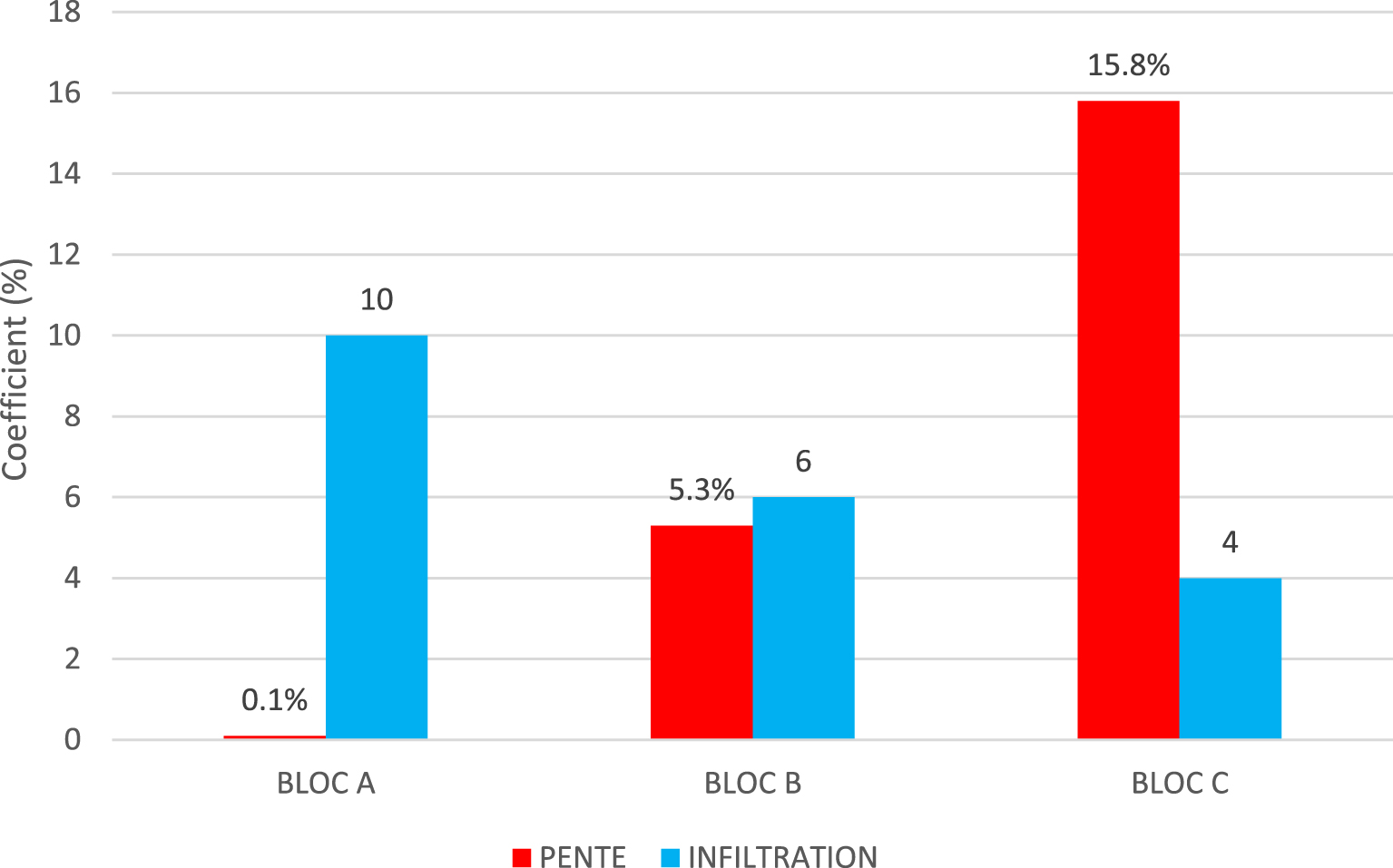
3.4.2. Soil types
The soil map highlights four major soil types: rocky (and erosional) soils, hydromorphic soils, sub-arid soils on sand, and halomorphic soils (Figure 5). A coarse-textured sandy soil allows more water to infiltrate (Figure 6) than a fine-textured sandy soil. Clay soil becomes impermeable after saturation. It does not favour infiltration.
Soil map of Biltine.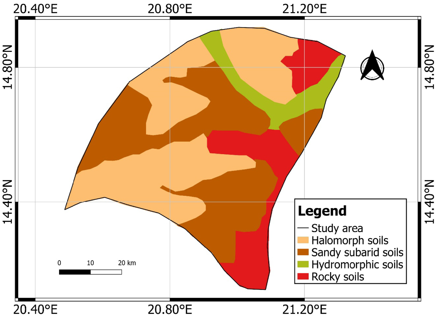
Infiltration by soil type.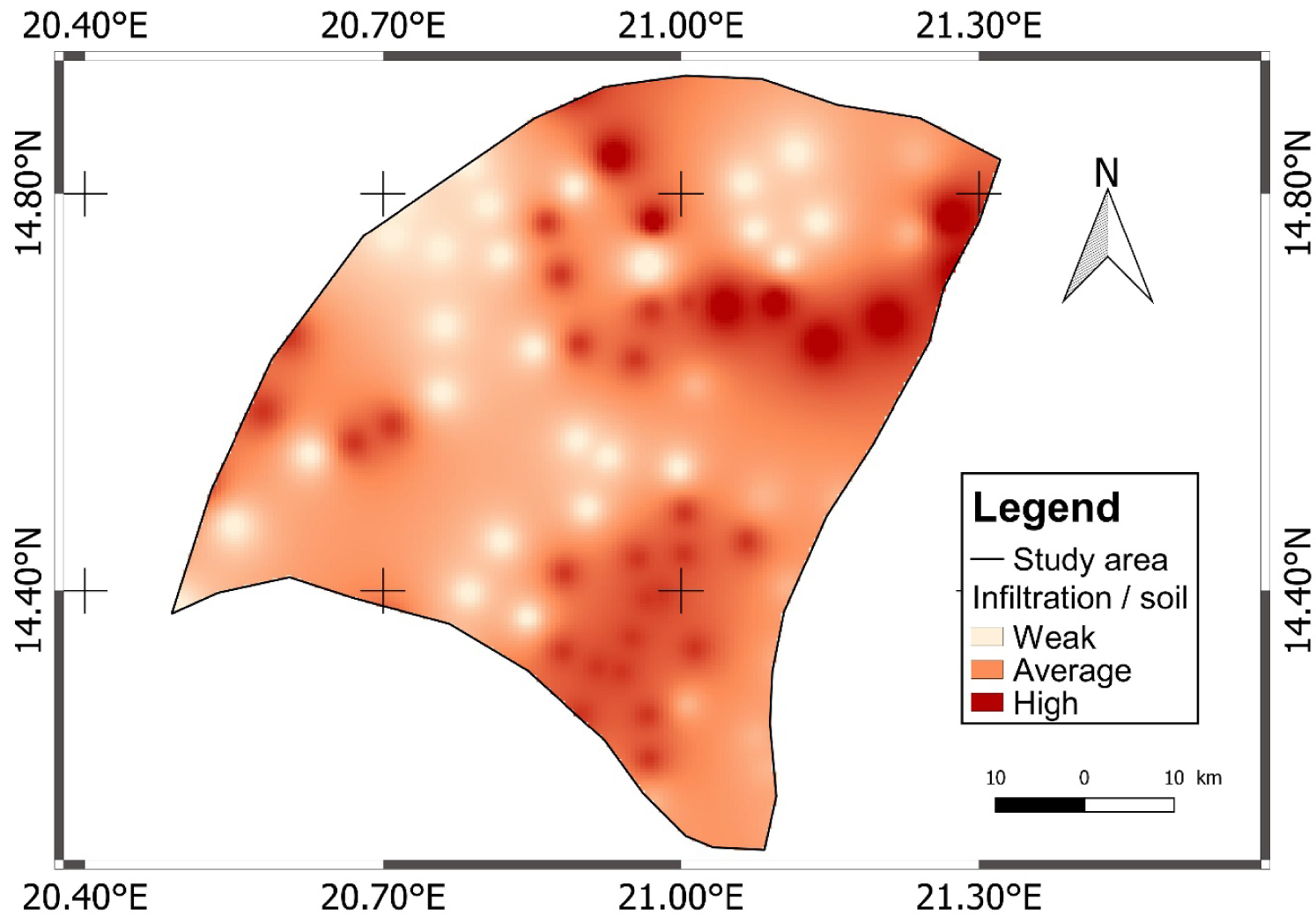
The permeability of rocky or erosion soils is medium to low. The permeability of sub-arid soils on sand is high. The same is true for the halomorphic soils that occupy the western part of the study area. Hydromorphic soils have a very high degree of permeability (Figure 6).
3.4.3. Land use
The study area is occupied by roads and patches of forest (Figure 7). Plants, through their leaves, protect the soil by reducing the impact of rain, then the root system improves the permeability of the soil. Plants slow down the flow of water to the surface by giving it more time to infiltrate. Housing reduces permeable surfaces. Roads also make soils impermeable.
Land use map.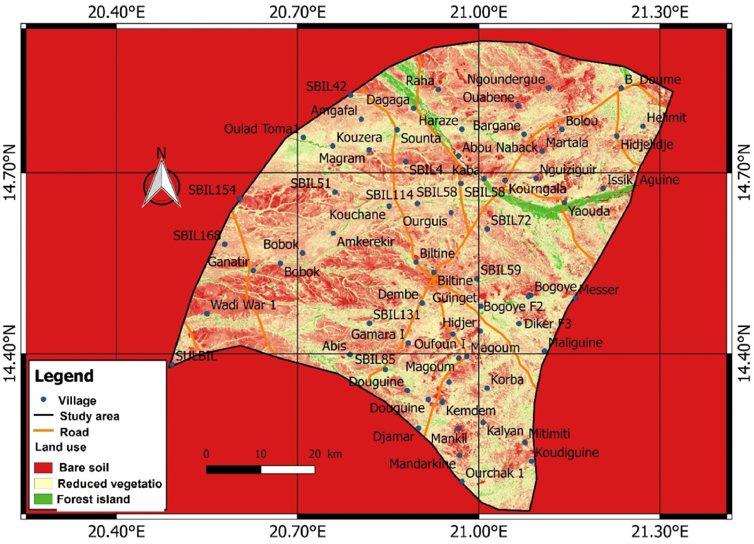
3.4.4. Thickness of alluvium and alteration
In the case of the latter, the lowest weathering thickness is 2 m (at Karti). In Toyone, the terrain shows high values of weathering thickness reaching 28 m. In general, the average weathering thickness is 19 m. The weak thickness of the alluvium is 1 m and the strong thickness is 7 m for an average of 5 m.
Weathering is a very important factor for recharge in the basement area. An altered basement has pores that can help water to circulate or remain.
The Biltine basement is highly weathered to the south, especially at Toyone and Kalyan. This strong alteration is also observed in Ganatir to the west. The degree of infiltration in the said localities should be high. The alteration is less developed towards the northeast. The interpolation map shows zero values towards the west (Figures 8 and 9). This is due to the absence of basement formations. This is a large area of plains.
Map of weathering thicknesses.
Infiltration according to the thickness of the alterites.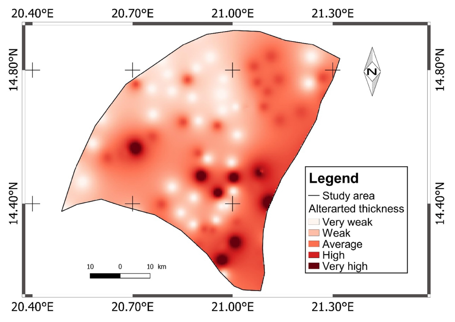
3.4.5. Fractured thickness
The strongly and very strongly fractured zones are located at Toumboulong with 43 m of fractured thickness. The least fractured areas are in Hidjelidje with 1 m of fractured thickness. The average fractured thickness of the area is 15.2 m.
Without the fractures, it is difficult or impossible for surface water to reach the deep bedrock zones and circulate. Fractures give aquifers the characteristic of permeability and conductive function. The basement of the study area has a good level of fracturing throughout (Figure 10).
Fractured thickness and infiltration map.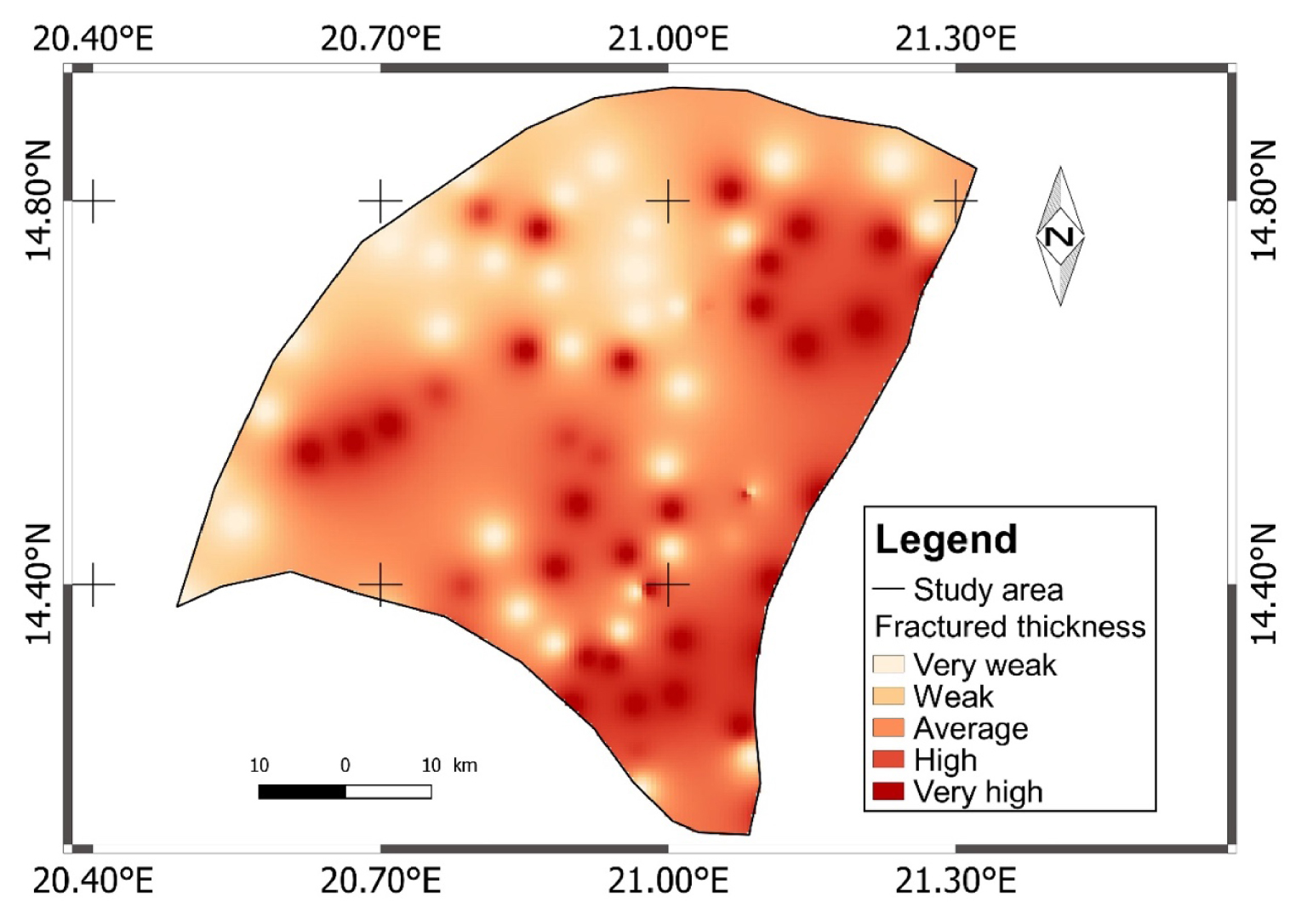
4. Results and discussion
4.1. Results
The map of potential recharge areas thus produced (Figure 11) shows five classes:
Map of potential recharge areas in Biltine.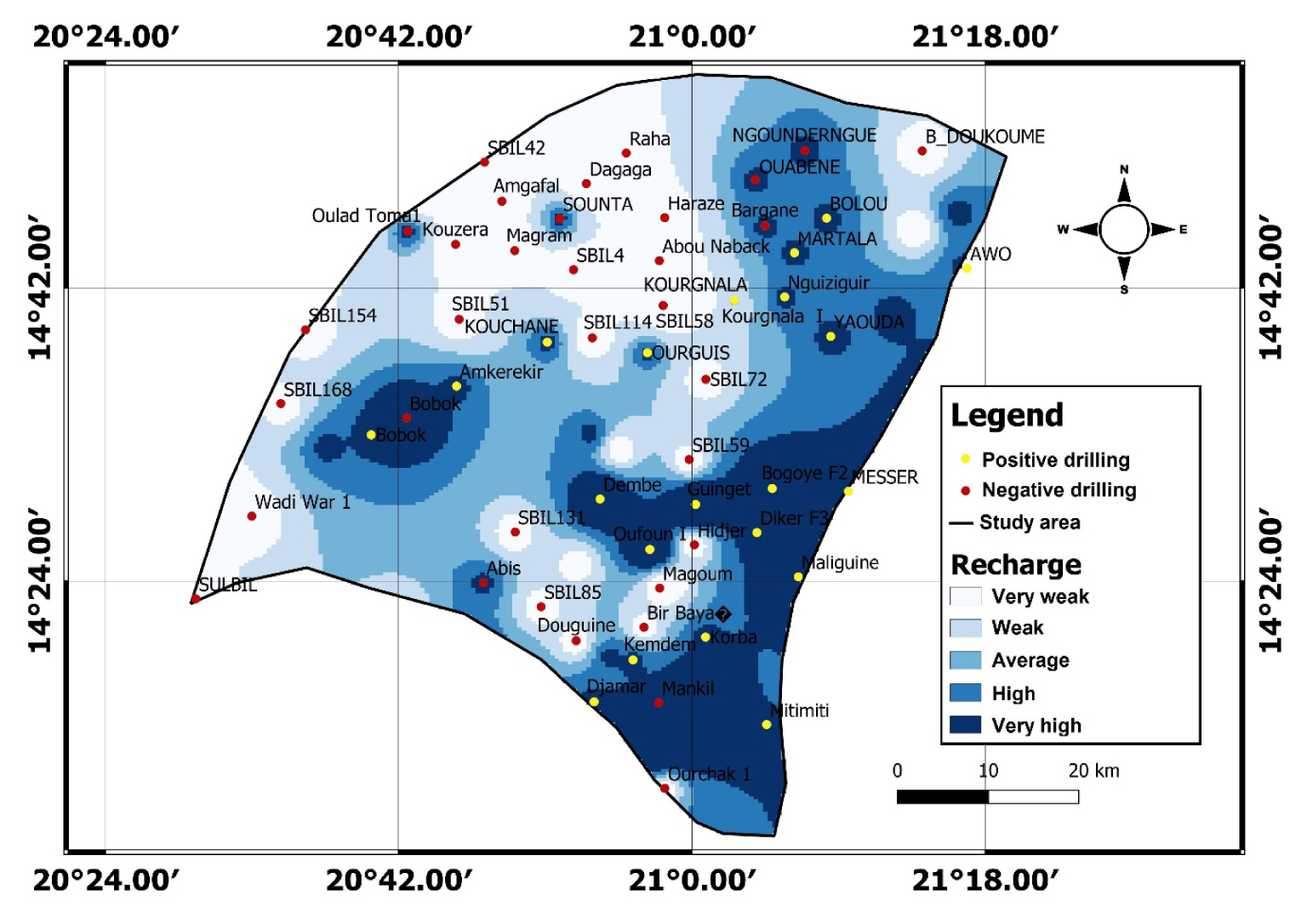
- The class of very low recharge: The land characteristic of this class represents 22.5% of the total area. In these sectors, the high altitudes would favour runoff to the detriment of infiltration.
- The class of low recharge: This class covers 26% of the area of the study area. In these localities, the slope is relatively low but the nature of the geological formations dominated by diorites and granites less fissured and less altered, would not be conducive to good infiltration.
- The class of medium recharge: It occupies 17.6% of the total area and scattered in the central part from southwest to northeast. This class is the result of a fairly weak drainage network that favours infiltration.
- The class of high recharge: Located from the South-East to the North-East, this class occupies 19.4% of the area studied. It surrounds the town of Biltine. This class would be the consequence of the density of the fractures of the basement contributing enormously to the infiltration.
- The class of very high recharge: It covers 14.5%, and represents only a small part (1/6) of the area studied. In these localities, the alteration and fracture of the land with considerable proportions, would have played an important role in the infiltration of water.
The projection of the boreholes on the map of potential recharge areas (Figure 11) leads to the determination that:
- 95.23% of the positive boreholes are located in areas of high recharge potentiality,
- 82.35% of the negative boreholes are located in areas of very low recharge potential.
4.2. Discussion
Located on a basement and on a locality that does not benefit from high precipitation, the study area has long been confronted with problems of groundwater availability. The aquifers in the locality are discontinuous with reduced storage capacities.
The geological formations in this study area are diverse. It should be noted that the sedimentary deposits of the locality are superficial and occupy only the first ten (10) m. These deposits are located in the ouadis. The thickness of these deposits is similar to those of the Saint-Germain-de-Cofolens lake [Maleval and Pitois 2017]. The eruptive and metamorphic rocks are highly fractured but are not highly altered. This low alteration in Biltine would be related to the longer dry season and the lack of permanent surface water in the locality as pointed out by Violette [2010]: In soils and saprolites, all weathering processes would be attenuated by the dry season. It is during the wet season that minerals would be mainly dissolved.
A single parameter alone cannot give the environment a favourable potential for groundwater recharge. For example: In Bornou Doukoumé, the fractured thickness is very large, but the locality is located in the zone with very low water potential. This confirms the study made in Côte d’Ivoire by Jourda et al. [2006] according to which; it is the climatic conditions, the density of fracturing, and the alteration that favor the accumulation of groundwater. However, the multi-criteria approach in conjunction with GIS is necessary to determine the spatial variability of recharge areas.
Most of the boreholes in the study area, which are located in the high and very high recharge sector, are positive. In this area, the combination of low slope, medium drainage density, medium alteration, and very high fracturing factors accentuate the degree of infiltration [Sombo et al. 2017]. Some productive boreholes are located in foothill areas where the slope is distinctly flat. Other positive boreholes that are mainly located on wadi beds would benefit from the favourable recharge characteristic of alluvium, consisting mainly of sands. Authors such as Musy and Soutter [1991] or Claeys and De Bondt [2008] confirm this hypothesis by saying that: the most favourable areas for rainwater recharge are those whose subsoil is made up of sandy formations.
The areas of low recharge potential are those located in the mountainous regions. It is clear here that the slope is very steep, the alteration is very weak, the vegetation is absent. These conditions do not favor infiltration. The low recharge in other places can also be explained by the impermeable sandy-clay nature of some soils that retain more water but do not let it through. Such water will eventually evaporate. This assertion is similar to the observation made by Jackli [1970] according to which, rainwater can infiltrate provided that there are no impermeable cover layers.
The different parameters of the methodology present diverse results. Most of the areas have low slopes. The drainage density of the area is relatively low. It does not exceed 1 km/km2. All the different soil types are permeable formations. The vegetation that should promote infiltration is very limited. The fractured thicknesses are in favourable proportions, but the altered thicknesses are not.
5. Conclusion
The multi-criteria approach associated with GIS is very useful for the determination of potential groundwater recharge areas. Thus, thanks to the methodology of the study of recharge parameters, a map of potential recharge areas has been established. This map appears as the first means of groundwater exploration in the Biltine basement.
The aim of this work is to highlight on a map the limits of the potentially productive areas of those non-productive.
It appears that the locality of Biltine is less productive. The zones of lower groundwater recharge occupy 43% (zone of very low and low recharge). Those with high recharge represent 37% (high and very high recharge areas). The high potential areas could be used for hydraulic drilling.
Declaration of interests
The authors do not work for, advise, own shares in, or receive funds from any organization that could benefit from this article, and have declared no affiliations other than their research organizations.