


 CC-BY 4.0
1. Introduction
For three and a half decades, the Out-of-Africa hypothesis has held that humans originated in Africa and subsequently spread to Europe and Asia. Inherent in the idea was a high likelihood that the land route across Lower Egypt and the Isthmus of Suez was an important exit from Africa to the rest of the world, possibly the main one. Water exit routes in that region would have included the Nile River, Red Sea, Gulf of Suez, Gulf of Aqaba, and Bab el Mandab. Now a unified genealogy of ancient and modern human genomes points to an inferred geographic center of gravity of the 100 oldest ancestral haplotypes, situated 280 km from the Nile River in Northeast Sudan (due north of Meroë) (Figure 1). Inferred human ancestral lineages over time and space further suggest a narrow, enduring corridor linking that center to the Levant of Southwest Asia (Wohns et al., 2022).
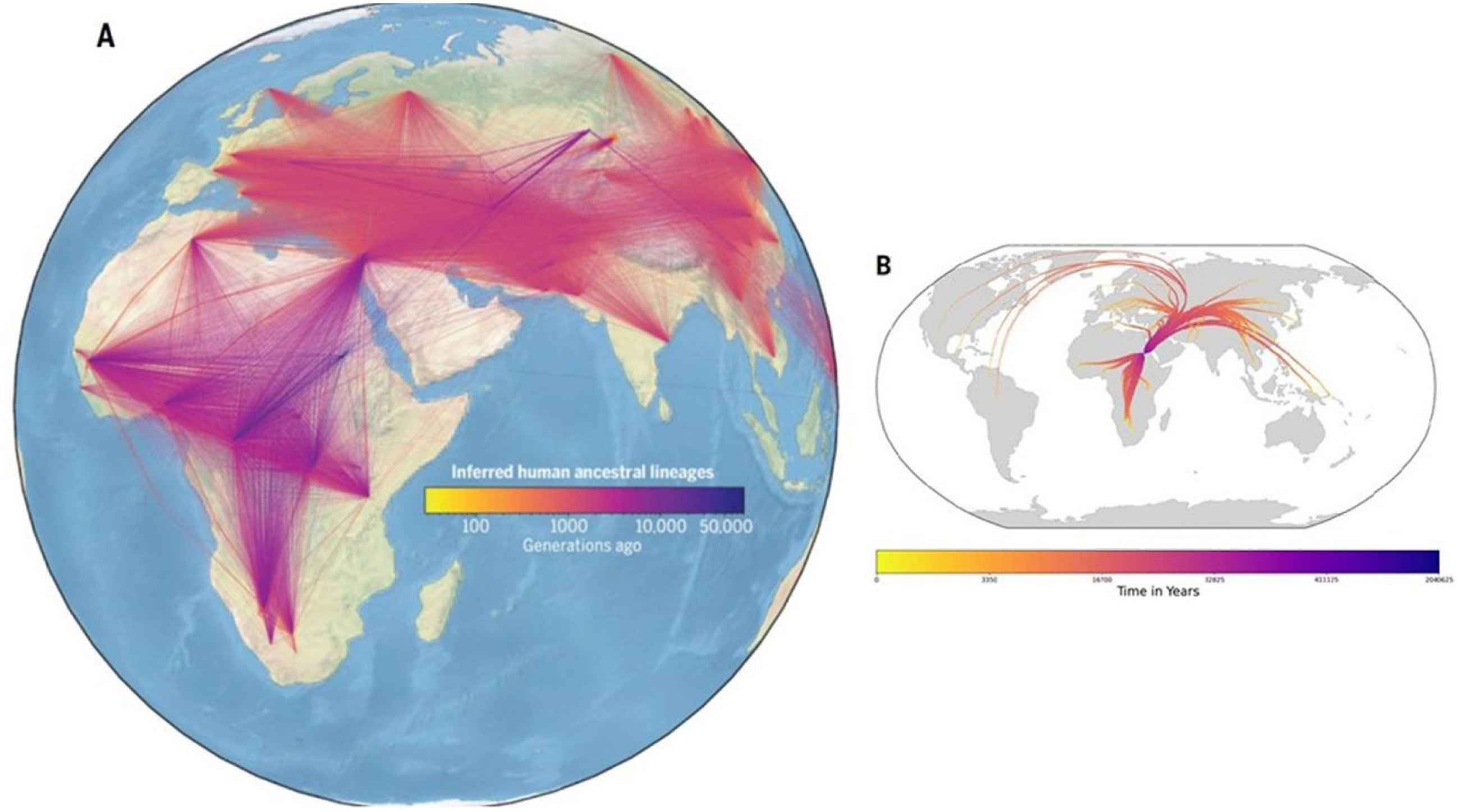
(A) Inferred human ancestral lineages over time and space. Each line represents an ancestor-descent relationship in inferred geneology of modern and ancient genomes. Line width corresponds to how many times the relationship is observed, and color intensities are based on the estimated age of the ancestor. (B) Visualization of the nonparametric estimator of ancestor geographic location, meaning the average location of the ancestors of each population from t = 0 to −2,000,000 ya. Widths of lines are proportional to the number of ancestors of each population over time. The ancestor is defined as an inferred haplotype with at least one individual in that population. Source: Wohns et al. (2022). Masquer
(A) Inferred human ancestral lineages over time and space. Each line represents an ancestor-descent relationship in inferred geneology of modern and ancient genomes. Line width corresponds to how many times the relationship is observed, and color intensities are based on ... Lire la suite
Yet, pre-dynastic archaeological sites in Egypt are surprisingly rare for such a crucial corridor lasting 2,000,000 years. A logical possibility is that physical artifacts were deposited in coastal lands when sea level was low and subsequently lost to the sea as its level rose. According to current consensus, the world ocean was at or slightly above its present level about 120,000 years ago, dropped to −55 m at 30,000 years ago, fluctuated dramatically in cycles, reached its lowest level (about −125 m) at the Last Glacial Maximum (LGM, about 20,000 years ago), and quickly rose to today’s level. The amount of land exposed and subsequently inundated worldwide is roughly equivalent to the land area of South America and amounts to an additional 11.6% over today’s land area. Thus, every human activity that took place in shallow seas, on beaches, or at varying elevations up to 125 m above contemporaneous sea level has been inundated. Most artifacts would have submerged sufficiently in depth and time to undergo substantial subsea impact.
The first known appearances of early modern humans outside Africa occurred in Israel by about 194,000 to 177,000 years ago (Stringer, 2016) and less certainly in Greece by 210,000 years ago (Harvarti et al., 2019). Sites in the Levant of Israel suggest a waypoint where migration routes from Africa converged for a long sojourn and then diverged to conquer Eurasia. Similarly, Tunisia and France appear to be linked through DNA, hinting at a Mediterranean crossing possibly via Sicily and Messina. Still, no exact routes are specifically known from the Levant, or Tunisia to France, nor onward to Europe and Asia. For example, the first known Homo sapiens fossils in Western Europe were found at Grotte Mandrin in southern France dating between 56,800 and 51,700 years ago (Slimak et al., 2022). Their Neronian lithic industry found there is “unknown in any industry of that age outside Africa”. However, no pathway to Mandrin has been proven from the Levant nor from Tunisia. These dates correspond to global sea levels of approximately −65 m and −78 m. Immediately before 56,800 years ago, sea level had risen dramatically from about −90 m to −65 m. It topped quickly at the precise date of Grotte Mandrin and then dropped rapidly so that it reached −78 m at 51,700 years ago and −100 m at 45,000 years ago.
Experts speak of a Northern Route through the Sinai into the Levant and a Southern Route across the Bab el Mandab to Arabia (Figure 2), but all confirming dates are at least 50,000 years earlier than our 30,000 BP window. Evidence confirming the Northern Route includes: Early human remains found in the Levant (Skhul and Qafzeh Caves) dated to 120,000–90,000 years ago and genetic studies of Y chromosome haplogroups suggesting the Levant as a primary migration path. Abbas et al. (2023) document detailed evidence of intensive travel via pathways from Wadi Gharandal via Sinai to the Levant. They further assess climatic conditions at the time and conclude in favor of a growing consensus for a well-watered Jordan Rift Valley. The main argument for the Southern Route is based on mtDNA studies suggesting a broad pattern of migration via the Horn of Africa. The main argument for Bab el Mandab is that it fits the “beachcomber” hypothesis, which proposes humans followed coastlines eastward, plus archaeological finds in southern Arabia dated to 100,000–80,000 years ago.
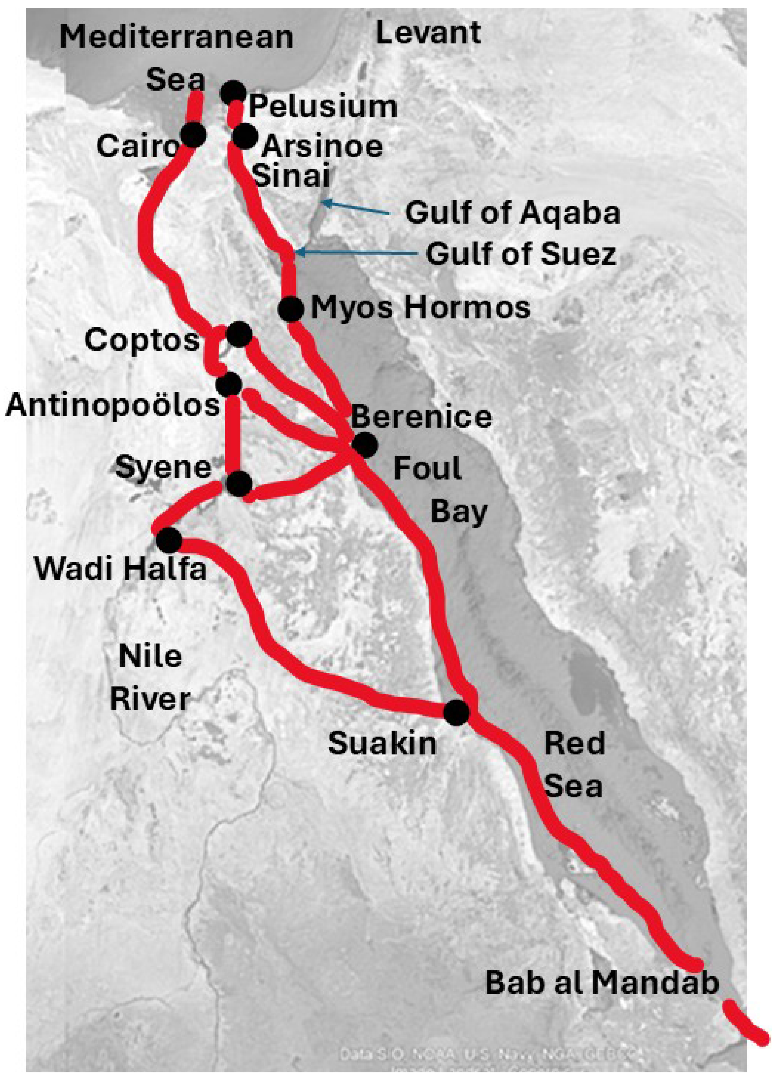
Reference map showing natural features cited, cities, and known routes connecting the Nile River, Foul Bay, Gulf of Suez, Red Sea, and Mediterranean Sea throughout history.
Here we retrospectively map drowned lands and publish our findings to help underwater archaeologists optimize their searches for lost evidence. The exact land routes from Sudan to the Levant are unknown, but migrants surely would have sought the same factors valued in historic eras. Thus, preferred routes likely would have traversed various segments of the Nile Valley, Red Sea, Isthmus of Suez, and Gulf of Aqaba in one way or another to reach the Levant.
2. Methods and materials
We follow Spada and Galassi (2017), who examined global sea levels from 30,000 BP to today and key intermediate dates. We employ a Glacial Isostatic Adjustment (GIA) model to account for the Earth’s deformation and gravity variations in response to glacial melting and for a “gravitationally self-consistent” reconstruction of paleotopography (Peltier, 1994). This iterative approach allows us to consider dynamically the role of isostasy in terms of the spatial and temporal evolution of submerged land and coastlines. In particular, we use SELEN4 (Spada and Melini, 2019), a model that extends the sea-level equation solver SELEN (Spada and Stocchi, 2007) to any given coastline, taking into account the horizontal migration of shorelines, the transition between floating and grounded ice, and the rotational feedback on sea level (Martinec et al., 2018). The computations adopt the latest version of the ice sheets’ chronology progressively developed by Kurt Lambeck and collaborators at the Australian National University (Lambeck and Chappell, 2001; Lambeck, Yokoyama, et al., 2002; Lambeck, Purcell, et al., 2003). The Earth is spherically layered, with a viscosity increase by a factor of 10 between the upper and lower mantle. In our GIA runs, a uniform equal-area grid (Tegmark, 1996) with horizontal spatial resolution of 20 km is employed; the total integration interval is 30,000 years with time increments of 500 years.
Data input models and variables include:
- Present-day topography constrained by the National Oceanic and Atmospheric Administration’s ETOPO1 global elevation database at 1 arc–minute resolution.
- Depth-dependence of density and rheological parameters (i.e., a spherically symmetric Earth model).
- A set of “Love numbers” (measures of spherical viscoelasticity for the Earth originally conceived by Augustus Edward Hough Love) to a given maximum harmonic degree (e.g., lmax = 256).
- A model for the present-day topography (ETOPO1) to define the present-day ocean function.
- A raster surface of the Earth on which the sea-level equation is discretized (global equal-area icosahedron-based spherical grid).
- Information about the geometry of the ice sheets and about their time-evolution in the time window of interest (an “ice model”). Preliminary analyses employed ETOPO1 global elevation data (Amante and Eakins, 2009) mapped eustatically by Dobson (2014), including cartography by Jerry Whistler and a geovisualization by Zong (2015).
Other global GIA models exist, e.g., ICE-6G_C (VM5a) of Peltier et al. (2015). With respect to the model adopted in this study, ICE-6G_C (VM5a) is characterized by different assumptions about the volume of the major ice sheets at the LGM, the chronology of de-glaciation, and the viscosity contrast between the upper and lower mantles. Using SELEN4, we have verified that regarding the evolution of topography since the LGM, the two models provide consistent scenarios for the geometry of the choke points. This has been verified even across the Bering Strait, relatively close to the former Laurentide ice sheet, where ice distribution and volumes differ significantly in the two GIA models.
3. Uncertainty and sensitivity
Understanding the uncertainties in our data and model results is crucial for accurately interpreting paleogeographic reconstructions. This section outlines the key uncertainties affecting our models of the Red Sea and Mediterranean Sea during the LGM and subsequent periods.
Our GIA model is sensitive to ice history, rheological parameters, and bathymetry. Key variables influencing the model include the volume and chronology of ice sheets, Earth’s viscosity structure, and sea-level data. The models rely on ice history reconstructions such as those developed by Lambeck, Yokoyama, et al. (2002) and Peltier et al. (2015). Differences in these reconstructions, particularly regarding the timing and extent of ice melt, introduce significant uncertainty. For the Red Sea and Mediterranean Sea, variations in the volume and timing of ice melt in far away Arctic and Antarctic realms can alter the predicted sea levels and shoreline positions.
Accurate bathymetric data are essential for reliable model outputs. We use the ETOPO1 global elevation database (Amante and Eakins, 2009), which provides a high-resolution baseline for present-day topography. However, discrepancies in bathymetric data can lead to errors in predicted shoreline positions and island formations. The Earth’s viscosity structure, particularly the contrast between the upper and lower mantle, affects the model’s predictions. Our model employs a spherically layered Earth with a significant viscosity increase between the upper and lower mantle, which is a standard but simplified approach. Sea-level proxies used for model calibration vary in precision and temporal resolution. We have incorporated multiple proxies to enhance model robustness. Nevertheless, the inherent uncertainties in these proxies contribute to the overall uncertainty of our reconstructions.
We verified our model results against alternative GIA models such as ICE-6G_C (VM5a) by Peltier et al. (2015). This comparison indicates that while broad trends are consistent, specific details such as the timing of shoreline changes sometimes differ. Both models have been calibrated using numerous sea-level proxies since the LGM, ensuring that the generated shorelines and island formations are robust across different scenarios. Our model consistently produces similar results across multiple runs further attesting to the reliability of our reconstructions.
Despite these uncertainties, retrospective mapping provides plausible paleogeographic reconstructions.
4. Background
This paper follows four published papers collectively written by Dobson, Spada, and Galassi. Initially, Dobson (2014) emphasized the importance of Aquaterra as a global feature. Aquaterra is the collective name for all lands that were inundated and exposed repeatedly during the Late Pleistocene ice ages from the early appearance of modern humans through today. Spada and Galassi (2017) refined the boundaries of Aquaterra at course resolution for the whole world ocean and at fine resolution for certain regions. They produced GIA reconstructions to account for the earth’s deformation and horizontal migrations of shorelines in response to glacial melting. Dobson, Spada, Galassi (2020) produced GIA reconstructions for nine global chokepoints—Bering Strait, Isthmus of Panama, Bosporus and Dardanelles, Strait of Gibraltar, Straits of Sicily and Messina, Isthmus of Suez, Bab el Mandab, Strait of Hormuz, and Strait of Malacca—to determine the status of each at the LGM, 20,000 years ago. Seven of the nine global chokepoints were dramatically impacted, and four of them—Bering Strait, Bosporus and Dardanelles, Strait of Hormuz, and Strait of Malacca—did not exist as navigable waterways. We conducted an in-depth analysis of the Bering Strait, noting especially the Bering Transitory Archipelago which was digitally discovered by us and would have been a stepping-stone pathway from Siberia to Alaska (Dobson, Spada, Galassi, 2021).
The most complex changes affecting distance and direction occurred at the Isthmus of Suez, thereby establishing the regional prominence of Foul Bay, Egypt (Figure 2). To minimize overland travel, a better alternative was Foul Bay to the Nile River at Syene (Aswan), Antinopolos, or Coptos, thence down the Nile River to the Mediterranean Coast. In particular, closure of the Gulf of Suez due to low sea level at LGM favored a dramatic shift in travel routes linking the Red Sea and Mediterranean Sea (Dobson, Spada, Galassi, 2020). If Berenike Troglodytica, a settlement on Foul Bay, existed at that time, it would have been the main beneficiary of any modicum of economic and population growth that occurred. We propose naming the hypothesized, now inundated, ancient port city Berenice Aquaterra.
Dobson, Spada, Galassi (ibid.) surveyed literature on ancient trade, transport, watercraft, potential cargoes, and durable structures such as stone buildings. We found sufficient evidence to suggest that boats and maritime travel, transport, and trade existed in a few locations around the world well before LGM, Australia about 65,000 years ago being the most cited case (Clarksonet al., 2017). Pottery and other likely cargoes were available. The oldest known stone structures date from 11,000 BP while Foul Bay retained most of its land. Hence, ports potentially spawned by increased trade in Foul Bay may still be detectable based on stone artifacts.
Here we study the push and pull factors that might have driven major changes in transportation and migration routes at LGM and afterward. We examine evidence of human occupance in Foul Bay. Our findings should be of interest to underwater archaeologists, anthropologists, historians, geographers, Egyptologists, and others interested in human settlements and migrations over the past 30,000 years.
Global choke points consist of two distinct geomorphologic types: straits which channel traffic through concentrated sea lanes or isthmuses which require overland crossings and favor short distances with unimpeded terrain. Straits facilitate maritime transport as does the open sea, while isthmuses inhibit maritime transport compared to open sea. The only isthmuses recognized as choke points are narrow and strategically positioned ones that consequently offer relatively less resistance and facilitate maritime shipments arriving from each side and departing from the other. The Suez crossing is an isthmus reached by open sea on the north and a long, narrow gulf on the south, but for the past century and a half it has functioned as a pseudo strait due to the Suez Canal. Foul Bay is neither a strait nor an isthmus, but it could have functioned as a pseudo isthmus due to its relatively advantageous overland crossing to the Nile River.
The Suez Canal is a global choke point channeling cargo between the Mediterranean Sea and Red Sea and thus today connecting the vast Mediterranean Sea/Atlantic Ocean and Black Sea realm with the vaster Red Sea/Indian Ocean/Pacific Ocean realm. In previous research, we and others demonstrated that at the LGM, the Gulf of Suez was exposed land, thus making the Isthmus of Suez a land barrier 520 km wide (north–south) (Dobson, Spada, Galassi, 2020). In this new research, we explore alternative crossings from Foul Bay (Sinus Immundus) on the western Red Sea Coast to the Nile River, thence downriver to the Nile Delta and into the Mediterranean Sea (Figure 2).
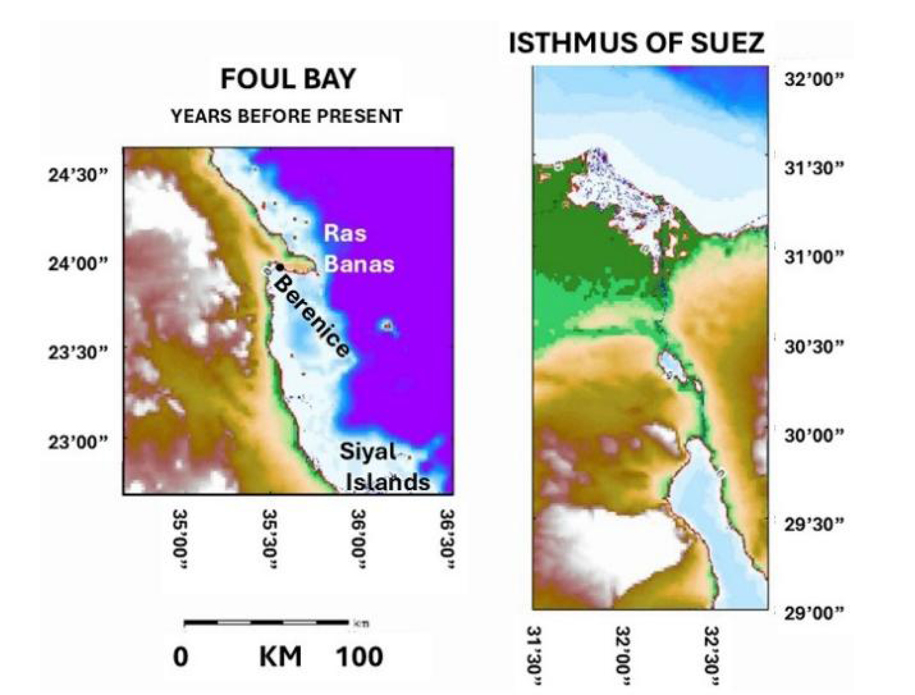
At LGM the route crossing directly between the Mediterranean Sea and Red Sea was a daunting portage (Figures 3 and 4). The Gulf of Suez remained dry land with little improvement in overland travel until after 14,000 BP. By 13,500 BP, lakes appeared, but they did not constitute a continuous waterway until about 13,000 BP. The gulf reached its full length in 8000 BP, and the shore of the Mediterranean Sea retreated by 7000 BP. From 30,000 BP, when our timeline begins, until 10,500 BP there was no Foul Bay. Indeed, the old coastline contained not even a natural harbor until about 16,000 BP. Approximately 80 km south of Ras Banas, the coast gently curved in a concave fashion but offered little shelter. The first reasonable harbor later formed 20 km south of the tip of Ras Banas and remained physically intact for the next 9000 years, reaching the dimensions envisioned by Strabo. Then suddenly, the rising sea reached the shallow base of Foul Bay’s floor, and the embayment filled rapidly, reaching its shape of today about 7000 BP.

Inundation of Gulf of Suez from 20,000 to 6500 BP.
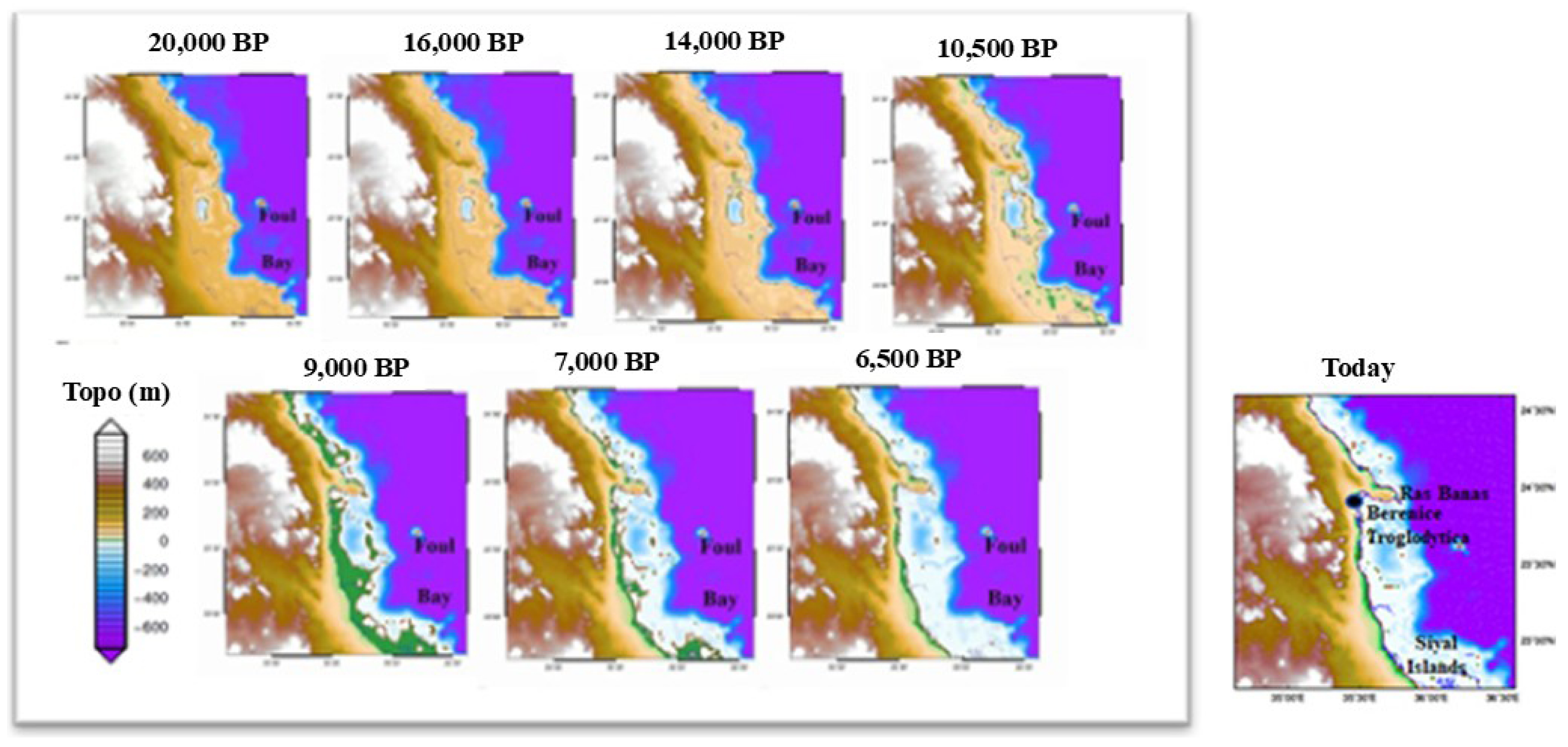
Inundation of Foul Bay from 20,000 to 6500 BP.
5. Animated comparison of changing transport advantage
To understand what sea level change did to transportation routes in Egypt spanning 30,000 years, readers must visualize change in three dimensions over time for two or more different locations. To facilitate such geovisualization, we offer both animations in the same frame, synchronized so that one timeline controls both simultaneously (Figure 5 and Supplementary Materials). Go to Supplementary Materials and click on the file name: suez-foulbay_geovisualization.mp4. When the two images form, you can control the animation from its timeline. Using the cursor and timeline at the bottom of the animated figure, readers can watch from beginning to end, stop action at any time to study in detail, or run continuously for any part of the whole. We ourselves began by watching 30,000 years of change over and over. Only in this way does one fully grasp the “synchronized swimming” of coastal lands over ages. Then we repeatedly stopped and started purposefully at 500-year increments. Only in this way can one compare what specific actions are occurring at Foul Bay versus the Isthmus of Suez.
Synchronized videos of Foul Bay and the Isthmus of Suez over 30,000 years of sea level fall to LGM and subsequent rise to today. (Reader, please see Supplementary Material to activate animation.)
6. Berenice Troglodytica
In ancient times, three cities in quite different locations were named Berenice (or Berenike). Berenice Troglodytica (or Trogodytai without an “l” in one case, probably an error) was on Foul Bay but not coincident with today’s Berenice. In 46 ancient maps (Kamal, 1926, 1928, 1932, 1933 and Supplementary Materials) the descriptive adjective Troglodytica appears 12 times, 4 of them attached to the city name and 8 as a region or district surrounding the town. Two other towns had the same root name Berenice. Berenice Epidire was south of the Bay of Aseb (Assab), which lies near the southern tip of Eritrea. Berenice Pancrisia (Panchrysos “all gold”) was a major center for gold mining and smelting generally thought to be somewhere inland, perhaps in Wawat, which was famous in ancient times but lost for centuries. Today, most sources place Berenice Pancrisia in Wadi Allaqi, Sudan, less than 4 miles from the Egyptian border and 70 miles inland (southwest of Foul Bay). These three cities appear to have been distinct, and their repetitive names are not considered to be indicative of uncertainty among cartographers. One map shows Berenice Pancrisia erroneously placed where Berenice Epidire should be, and that appears to be an unrelated error. To add to the confusion, there are three other Foul Bays in the world: one on Tiran Island at the northern end of the Red Sea, one on Barbados, and one in Australia.
Berenice Troglodytica on Foul Bay was a major port 2000 years ago. The standard account is that it became a port in 275 BCE and was named by Ptolemy II Philadelphus for his mother Berenice I of Egypt. It was prominent for a while as a transshipment point for elephants heading first from India and later from present Eritrea to Lower Egypt for military deployment against the Seleucids.
Geographers from Strabo to Ellen Churchill Semple cited goods from India following the inland route from Berenice. “Hence under Greek and Roman rule in Egypt the Oriental products continued to move overland from Leucos Limen (Quseer, Myos Hormos) or Berenice to Coptos on the Nile, and thence by river down to Alexandria, whence they were exported to all coasts of the Mediterranean.” (Semple, 1939, p. 169) And enormous sums changed hands, “Aside from the costly carriage by donkey or camel caravan from the Red Sea, traffic charges by this marine and river route were heavy: they included transit duties on all goods entering and leaving Egypt, and customs ad valorem imposed at the frontier of the various nomes or provinces, where custom houses were maintained or a bridge of boats blocked the passage.”
The archaeological evidence from Berenice includes remnants of harbors, warehouses, and other infrastructure that supported commerce at least as far away as India. Discoveries through 2012 included early Roman ship timbers, large ropes, thin fragments of lead (some with nail holes), a cattle cemetery (Sidebotham and Zych, 2012), and a pet cemetery (Tarlach, 2021; Osypinska et al., 2021). Team members attempted with partial success to delineate harbor walls. A geophysical survey of the site was completed in 2014 (Zych et al., 2016). Zych and Sidebotham (Archaeology Magazine, 2014) and Sidebotham, Zych, et al. (2015) unearthed part of a ship’s hull while studying a Hellenistic fort, Roman harbor, and Late Roman temple and conducting other fieldwork.
A recent summary reveals revolutionary new understandings of Berenice (Marchant, 2024). The site itself is described in vivid detail with startling ties to India, not merely in trade goods but in cultural and business ties with India. The first Buddha statue ever found west of Afghanistan was discovered in this “once-bustling, cosmopolitan port city from which mighty ships laden with gold and wine sailed across the ocean and brought back spices, jewels, perfume and other exotic cargo … driving a broad reassessment of the interconnectedness of the ancient world …. One Greco–Roman text, known as the Periplus Maris Erythraei … lists the port as a hub for maritime trade routes stretching south as far as modern-day Tanzania, and east, past Arabia, to India and beyond … by the first century A.D., the Roman tax revenues from Indian Ocean trade may have generated as much as one-third of the [Roman] empire’s total income … [or] perhaps at 10 or 15 percent lower …” Site archaeologist Steven Sidebotham and team have “uncovered mounds of administrative detritus, including letters, receipts and customs passes, and imported treasures such as ivory, incense, textiles, gems and foodstuffs such as pots of Indian peppercorns, coconuts and rice.” He hopes “beyond” will prove to be China, but no evidence of that has been found. We urge investigators to explore new horizons in time as well as space, while we ourselves search for Berenice Aquaterra.
According to Woźniak (2021), “Abraq (discovered in 1832) was a large Hellenistic fort located in the mountains southwest of Berenike. A survey by the Berenike Project in the 1990s traced an overland trail connecting the fort to Syene (Sidebotham, 2011, pp. 41–42, 128). The eastern part of the route could have led to Berenike, according to the researchers, although this would have been a rather roundabout way, Abraq being too far south. A much shorter and equally convenient route … from Berenike to Syene would have led through via Wadi Abu Greiya, for example. Assuming a certain similarity of the trail in question to the well-known routes from Berenike or Nechesia to Edfu and Koptos, its final destination on the coast (a port?) would have been southeast of the Abraq fort, that is, south of the present port of Shalateen … it could have been an “alternative” or “rescue” route …”.
Berenice Troglodytica was active as an east–west connection between the Red Sea and the Nile River in the 1st and 2nd Centuries CE and again in the 4th Century CE, noted by geographers Strabo (64 or 63 BCE–24 CE), Pliny the Elder (23–79 CE), and Stephanus of Byzantium (6th Century CE). A road ran directly westward to the First Cataract of the Nile River at Syene (now Aswan), closely following the Tropic of Cancer. After 137 CE the Via Hadriana ran from Berenice to Antinopolos (Antinoöpolis, Antinoopolis, Antinoë) for trade heading upriver into Nubia. A third road ran from Berenice to Koptos during the Roman era. The port was abandoned after the 6th Century CE, and all three roads fell into disuse. Berenice itself disappeared until 1818 when ruins were identified by Giovanni Battista Belzoni (1778–1823), confirming an earlier opinion by Jean Baptiste Bourguignon d’Anville (1697–1782).
7. Berenice today
Berenice, Egypt is a small port town located at the northernmost end of Foul Bay and sheltered from the Red Sea by Ras (Head) Banas. Google Earth and other modern sources still label it Berenice Troglodytica, but many maps simply say Berenice, Baranis, or Berenike. Foul Bay itself extends about 150 km north-south and 20 to 45 km east–west. It served as a port of call for the U.S. Sixth Fleet in the early months of the Persian Gulf War (1990–1991). The town contains a small Bedouin Museum, a few unmarked structures, and a major archaeological site, the so-called Temple of Serapis. The temple reputedly was built by Trajan (53–117 CE), but archaeologists from the Polish Center for Mediterranean Archaeology discovered in it a pair of reliefs, one dating from 2134–1690 BCE and the other 1674–1549 BCE, far older than Trajan or the town itself (Archaeology Magazine, 2014).
Archaeological excavations have been underway continuously since the mid-1990s, notably by Sidebotham (University of Delaware), Zych and Rądkowska (University of Warsaw), Woźniak (Polish Academy of Sciences), and Wendrich (University of California at Los Angeles and Leiden University). Funders have included the Netherlands Foundation for Scientific Research, National Geographic Society, Netherlands Ministry of Foreign Affairs, Samuel H. Kress Foundation, University of Delaware, UTOPA Foundation, and American Philosophical Society.
8. Tectonic forces and movements
The only competing force capable of negating the hypsometric impacts of changing sea level would be vertical tectonics, which are not included in our GIA adjustments. Certainly, there has been substantial movement in the past because Foul Bay and the Gulf of Suez lie on active plate boundaries (Bosworth et al., 2019). Here, however, we are concerned only with a specific time period—30,000 BP to about 8000 BP—direction offsetting the impact of sea level change by rising when sea level was falling (30,000 BP to LGM) or falling when sea level was rising (LGM to 6500 BP), and only three relatively small areas—Foul Bay, the Gulf of Suez, and the Isthmus of Suez where the Suez Canal now lies. Despite its proximity to the Red Sea Rift, Foul Bay shows no evidence of measurable tectonic activity in the relevant period. Focusing on Zabargad (St. John) Island, which lies on the plate boundary 40 km east of Foul Bay and El Ikhwa (Northern Brother) Island, which is also on the plate boundary 275 km north of Foul Bay, Hoang and Taviani (1991) concluded that both islands had been “tectonically quite stable” for 125,000 years. Likewise, maps presented by Bosworth et al. (2019) show no recent tectonic activity in or near Foul Bay.
The Gulf of Suez has been more active. According to Bosworth et al. (ibid.) “All of the margins of the … Gulf of Suez … underwent tectonically-driven rift shoulder uplift and denudation in past, particularly during the main phases of continental rifting. However, during the past 125 ka uplift has been much more focused and most pronounced at the footwalls of a few, active extensional faults. These include a few major faults in the Gulf of Suez …” The most prominent of these faults are Gebel Tanka and Gebel Zeit-Shadwan Island, both of which are oriented parallel to the Gulf of Suez route and therefore would not have impeded water flow nor human transport even if all of their vertical movement had occurred during the relevant time period.
9. Other hypothesized crossings
It is essential to consider all land and water routes that may have facilitated human migration in and out of Africa when sea level was high or low. Here we mention three potential crossings: (a) the Gulf of Aqaba, (b) the Bab el Mandab, and (c) the Straits of Sicily and Messina.
Gulf of Aqaba: When our research began, we were interested primarily in traffic between the Red Sea and Mediterranean Sea. As the work progressed, our focus shifted to include the Levant. For consistency, it would have been good to have the same retrospective GIA mapping for the Gulf of Aqaba as for the rest of the region. Fortunately, Aqaba is so different from Suez that GIA precision is unnecessary. It is so deep throughout its length, and its shores are so steep that (a) it would have been navigable end to end even at LGM, (b) its width changed little, (c) the lengths of routes were little affected, and (d) tectonic activity would not have blocked transport (Sade et al., 2009; Hamouda and El-Gharabawy, 2019). Thus, it was open and may well have been an important route from the eastern shores of the Red Sea toward the Levant.
Bab el Mandab: Reconstructions of the southern Red Sea by Inglis et al. (2019) provide valuable insights. Studies by Bailey, Meredith-Williams, et al. (2019) emphasize the Bab el Mandab’s role in facilitating movement from Africa to the Arabian Peninsula. Many sources say that narrowing of the Bab el Mandab would have made it a viable crossing. However, our retrospective GIA mapping finds that its east–west width was never less than 3 km even at LGM (Dobson, Spada, Galassi, 2020). This narrowing would have made it a dangerous crossing for small craft. Significantly, Wohns et al. (2022) show extremely weak DNA linkages to nodes east of Bal al Mandab, compared to strong linkages across the Isthmus of Suez. Together the incomplete closure and weak DNA connection lead us to deemphasize Bab el Mandab in our study.
Straits of Sicily and Messina: At LGM the Mediterranean Sea was almost two separate seas divided by the Island of Sicily, the closed Strait of Messina, and the narrowed Strait of Sicily. Still, the water crossing was 52 km wide and at least 80 m deep (Dobson, Spada, Galassi, 2020). There is reason to suspect that the first modern humans in France crossed via these islands, based on a prominent inferred geographic center of ancestral haplotypes in northwest Africa and scattered ones across in Mediterranean Europe.
10. Origins of Egyptian cultures
What difference might an alternative pathway (that is, Foul Bay to Nile Delta versus the Suez crossing) have made in the prehistoric settling of Egypt and subsequent development of Egyptian cultures? We hypothesize that the Suez crossing alone, whenever advantageous, would have favored settling the Nile Valley from north to south. The crossing itself is at the northern extreme, and anyone heading southward from the Mediterranean Sea could have chosen to navigate directly up the Nile River. Conversely, anyone heading northward from the Red Sea could have veered westward to the Nile Delta on a route so level and unimpeded that for a while it served as Necho’s Canal (Lloyd, 1977). Logically, the Suez crossing would have contributed little to development in southern Egypt, except that some travelers might have rejected that route because of its length and intervening coral hazards and crossed instead from Myos Hormos to Coptos in Upper Egypt, which at 150 km is the shortest of all crossings between the Red Sea and Nile River. Assessing Greco-Roman ports on the Red Sea, Kotarba-Morley (2019) states, “… beyond brief references in classical texts …” Regarding the western Red Sea Coast Woźniak (2021) says, “… Myos Hormos (Quseir al-Qadim), Nechesia (Marsa Nakari) and Berenike have been located and surveyed … and, in the south, Ptolemais Theron (Nowarat delta in Sudan) and Adulis (Galala in Eritrea). Notably, these sites are located at regular distances, every 150–200 km. Locations were chosen either at existing sites or, for the most part, in places without earlier settlement … The only region where such centers were not recorded is the section between Berenike and Ptolemais Theron.” Both Kotarba-Morley and Woźniak list Adulis, which is located in Eritrea near the Bab el Mandab, too far south to have influenced settlement in Egypt.
A true test of the north to south settling hypothesis would focus on the LGM and associated millennia when sea level was low enough to influence collective travel habits. We ourselves confidently model isostatic sea level for the past 30,000 years but not earlier due to ice data limitations. Based on this constraint and sea level curves, we select a time window of 30,000 to 6500 BP. Hominin occupance1 lasting hundreds of thousands of years has been documented in the Nile River Valley and more broadly in Northeast Africa, the Sahara Desert, Sudan, the Levant, and so forth. The evidence starts with Homo erectus and continues to modern human predynastic cultures that are clearly Egyptian (Shaw, 2003). Ideally, the test should include unassailable demographic data for the entire Nile Valley, Foul Bay, Isthmus of Suez, and neighboring regions. However, archaeological data from excavations covering the relevant years are quite sparce.
Traditionally, scholars have divided the Nile River Valley into Lower Egypt, which includes the entire Nile Delta plus about 100 km of the river valley upstream from Cairo to Beni Suef (29°N, near Giza) and Upper Egypt which extends from Beni Suef to the First Cataract of the Nile (24°N) at Syene (Aswan). Many sources, starting in the 19th Century, further divide Upper Egypt into Middle Egypt from Beni Suef to Sohaq (26°33′N) versus the remaining Upper Egypt from Sohaq to Aswan. Accordingly, for this study, we define Lower Egypt from 31°35′N to 29°N, Middle Egypt from 29°N to 26°33′N, and Upper Egypt from 26°33′N to 24°N.
Egyptian culture derives from two distinct cultural hearths, Al-Badārī (4400–4000 BCE) (ibid.) and Naqada (4400–3000 BCE) (Petrie and Quibell, 1895; Shaw, 2003; Dee et al., 2013). Both existed in predynastic Egypt beside the Nile River. Al-Badārī lies in Middle Egypt halfway (335 km straight line distance) upriver from Giza and 325 km downriver from the First Cataract of the Nile. Naqada lies near Coptos, thoroughly in Upper Egypt about three-fourths of the way (500 km) upriver from Giza and 150 km downriver from the First Cataract.
Where, in turn, did the forerunners of these predynastic cultures reside before migrating to their known sites? A litany of studies, complementary or contradictory, suggest a “melting pot” of diverse origins for Al-Badārī (Shaw, 2003), which itself may date as early as 7000 BP (Watterson, 1998). Shaw cites and rejects an early Tasian culture with precursors in Lower Egypt and Neolithic Sudan, but he does allow for a nomadic Sudanese influence on Badari culture. He further cites likely origins in the Sahara Desert and possibly the Levant. Side-blow flakes are characteristic of Badari and certain cultures in the Sahara. Characteristically Badarian artifacts have been uncovered well beyond Al-Badārī as far as Hierakonpolis (100 km from Aswan), suggesting that the culture may have extended far into Upper Egypt. Shaw (2003) says, “Relations with the Red Sea are attested through the presence of Red Sea shells in graves, while copper ore may have come from the Eastern Desert or the Sinai … If there were contacts between the Badari region and the Sinai, they most probably passed through the Eastern Sinai rather than Lower Egypt.” In this case, the most likely ports into and through the Eastern Desert would be either Myos Hormos or Berenice to Coptos.
Naqada’s origins have been heavily debated. Here we revisit existing literature in search of indicators that may point toward one migration pathway or another. Hypothetically, if Naqada was settled primarily from Nubia (south) or, alternatively, from the Sahara (west) or Levant (east) or Europe (north), what would that say about sea to sea crossings? Settlers arriving via Foul Bay could go directly into the Upper Nile but so might settlers from Wadi Halfa and the rest of riverine Nubia. Settlers from the Sahara might go directly to Upper Egypt but also to Middle or Lower Egypt. Migrants arriving from Europe or the Levant might cross the Isthmus of Suez but traveling east to west, rather than crossing north to south, and then continuing southward upriver. Once in the Nile Valley, they might settle anywhere from the Nile Delta southward to Aswan.
The consensus gleaned from current research shows a melting pot of diverse cultures sharing biological traits in many directions (Figure 6). Close biological affinities link Naqada with its neighbors in the Nile Valley including Al-Badārī some 175 km upstream, and that is true for thousands of years with predecessors, contemporaries, and descendants. The next greatest affinities are with Mesolithic Nubia. Lower Egypt forms a homogeneous group, which is part of an overall gradient from least Naqada affinities in the north to greatest in the south (Godde, 2018). Conversely, Naqada’s weakest affinities are with ancient Europe, the Levant, the Tropics, and certain stretches of the Nile Valley itself.
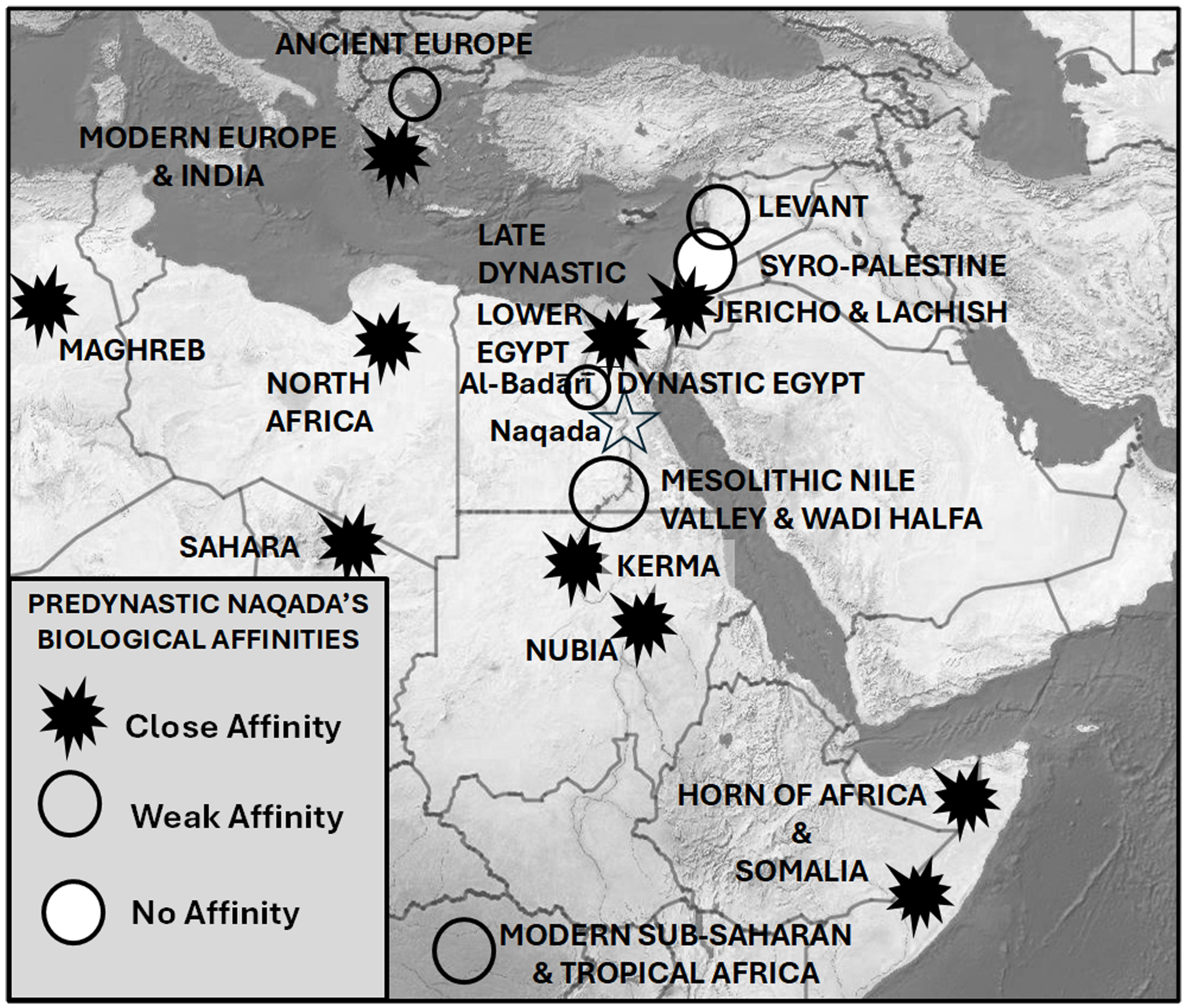
Distributions of biological affinities described in Brace et al. (1993), Hanihara et al. (2003), Keita, Kryaniak, et al. (1996), Godde (2009), Godde (2018), Keita and Boyce (1996), Prowse and Lovell (1996), Lovell (1999), Chrisco (2022), Ehret (2023). All affinities represented here apply to predynastic Naqada except those otherwise noted on the map.
Among nine archeological sites in the Nile Valley at least 5000 years old, none are in Lower Egypt, one is in Middle Egypt, five are in Upper Egypt and three are in Nubia (Table 1). Hence, the actual pattern of early settlements favors settling northward from Nubia or westward from Foul Bay or Myos Hormos to the Nile River and downriver. The timing of both sites at 6400 BP, however, comes late in the inundation of Foul Bay, when almost all of its water had returned, and any influence on settlement would have been inertial at best.
Archaeological sites in the Nile River Valley at least 5000 years old
| Site name | Age | Location (common language) | Longitude | Latitude | Major division |
|---|---|---|---|---|---|
| Jebel Sahaba | 15,000–13,000 BP | Near Wadi Halfa, Sudan | 31°24′E | 22°30′N | Nubia |
| Nabta Playa | 11,000–8000 BP | Western Desert, Egypt | 29°12′E | 22°18′N | Nubia |
| Bir Kiseiba | 15,000–12,000 BP | Near Abu Simbel, Egypt | 23°52′E | 22°31′N | Nubia |
| Wadi Kubbaniya | 14,000–12,000 BP | Near Asyut, Egypt | 32°48′E | 25°54′N | Upper Egypt |
| Nazlet Khater 4 | 14,200–11,100 BP | Near Sohag, Egypt | 31°09′E | 27°15′N | Middle Egypt |
| Taramsa Hill | 6200–5200 BP | Near Qena, Egypt | 32°50′E | 25°48′N | Upper Egypt |
| Naqada | 5800–5000 BP | Near Luxor, Egypt | 32°46′E | 25°58′N | Upper Egypt |
| Hierakonpolis | 5000–4000 BP | Near Edfu, Egypt | 32°43′E | 24°53′N | Upper Egypt |
| Badari | 5000–4000 BP | Near Asyut, Egypt | 31°27′E | 26°08′N | Upper Egypt |
11. Uncertainty regarding Berenice’s location
Here we note that diverse locations are given for Berenice Troglodytica on ancient maps, and we ask why.
The American Geographical Society Library (AGSL) in Milwaukee, WI, holds a 16-volume Atlas, the Monumenta Cartographica Africae et Aegypti edited by Kamal (1926−1952) which was given to the Society by editor Kamal, a prince of Egypt. It contains copies of the oldest known maps of the Red Sea and Africa, and only a few copies exist in the world. Dobson studied one copy at the Egyptian Geographical Society in 1999 and another at AGSL in 2018. He examined 46 ancient maps of the Red Sea containing the basin now occupied by Foul Bay (Kamal, 1926, 1928, 1932, 1933; See Table S1 in Supplementary Material). Taking photographs and extensive notes, he analyzed Foul Bay and especially the location of Berenice. He found that there was indeed much confusion among ancient cartographers about the location of Berenice. Of 43 maps that show Berenice, 17 place it at the northern end of Foul Bay, 19 in the middle, and three at the southern end. Three maps even point to one site at the northern end plus an alternative site in the middle with a cartographer’s note saying, “Berenice according to the opinion of some Geographers” (Figure 7). The other two doubtfully say “Position attrìbuée à Berenice.” The confusion is pervasive and also clearly stated as scholarly uncertainty by three separate teams of cartographers. The earliest known maps of the Red Sea Coast do not resolve Berenice’s location even in early historic times, much less in prehistory.
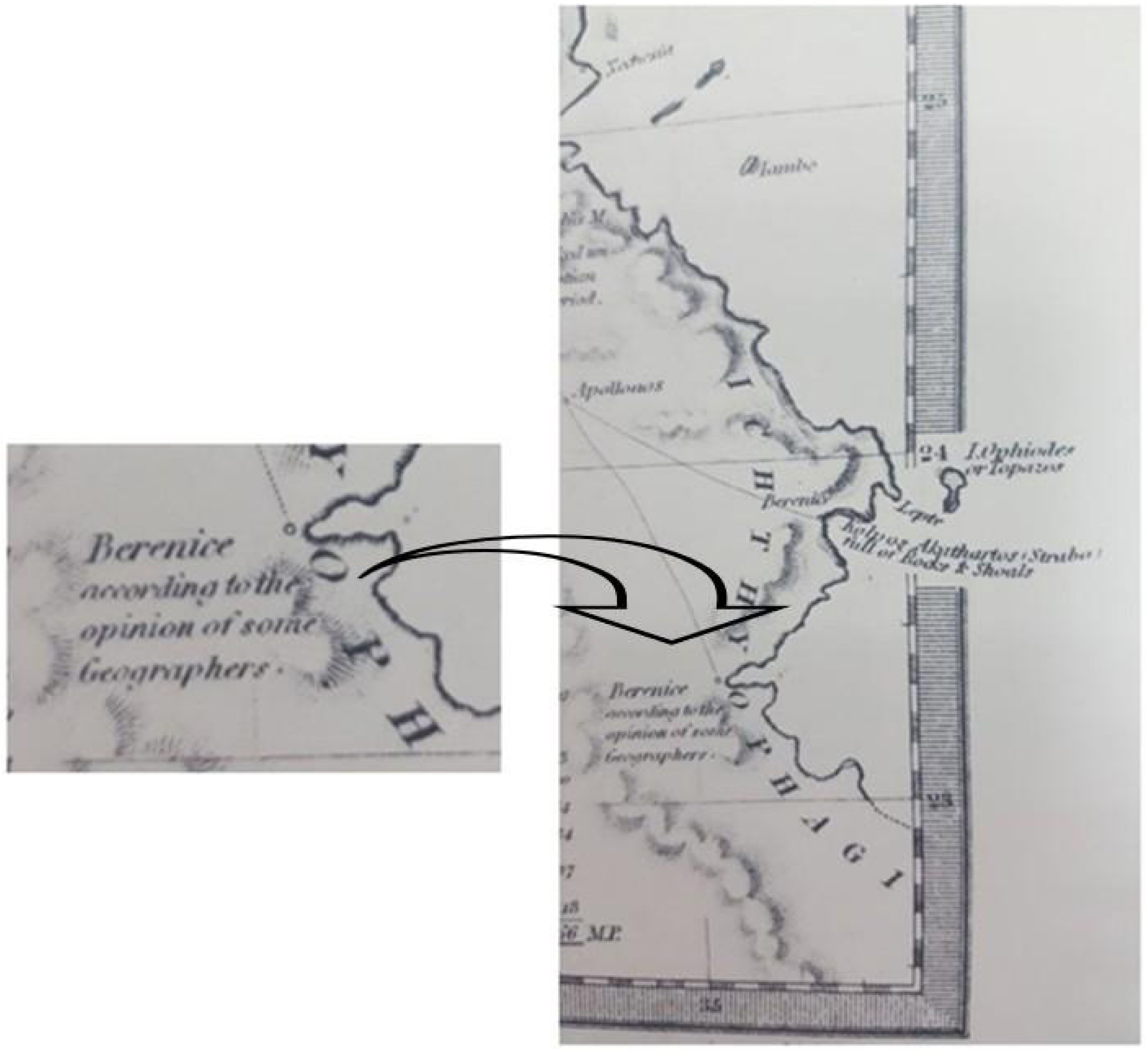
“Berenice according to the opinion of some Geographers.” Source: Long, G. ed. J. Mickleburgh, “Ancient Egypt.” Maps of the Society for the Diffusion of Useful Knowledge, London, 1844.
No one knows how many people lived in the exposed land subsequently inundated by the rising Red Sea. There is no evidence to suggest a dense population, but neither is there evidence to exclude it. There is no evidence to suggest a settlement with a port function, but neither is there evidence to exclude it. Hence, in fairness, we consider Scenario A with few people and no port versus Scenario B with many people and a port settlement capable of handling cargo and trading inland and seaward.
In Scenario A, a scattered, low-density population simply would have dispersed to nearby lands as sea level rose. The influence on subsequent population and settlement patterns in lands surrounding Foul Bay would have been minimal.
In Scenario B, however, total population likely would have declined substantially as (a) land, roads, and buildings were lost to rising water and (b) the city’s port function diminished as traffic shifted back to the rapidly improving Suez route. Vestiges of the old city would have migrated upward contour by contour, retaining any high ground that continued to be viable near shore. With this inundation process in mind, we suspect that population dispersal would have occurred outward in all directions from Foul Bay and along the east–west route from Foul Bay to the Nile River. If a port city existed and especially if it were sizable enough to occupy much of the basin, its footprint (x,y) would have migrated erratically depending on hypsometric (z) patterns. Its precise location might well have confounded 19th Century cartographers and other scholars who were unaware that inundation had occurred below. Thus, the uncertainty about the location of Berenice observed in ancient maps and in diverse opinions much later favors Scenario B over Scenario A.
Why such uncertainty? The logic of Scenario B suggests that a city may have developed on the exposed floor of Foul Bay’s basin as sea level fell to −125 m and remained low for several thousand years. We suggest naming the hypothetical city Berenice Aquaterra to avoid confusion with the three known Berenices. We envision a theoretical scenario in which a settlement occupying substantial portions of Foul Bay was gradually inundated as shown in Figure 4, based on time slices within a 30,000-year reconstruction. Due to steep slopes at lower depths, Foul Bay’s horizontal extent of inundation was insignificant until about 16,000 BP. Losses of coastal lands were noticeable by 14,000 BP and substantial by 10,500 BP. Most of the basin was inundated by 9000 BP, but scattered remnants of its bottom remained as late as 7000 BP. Inundation was complete by 6500 BP.
12. Searching for ancient stone artifacts in Foul Bay
It is generally accepted that no stone pyramids existed before the earliest one visible above sea level today; that is Djoser’s Pyramid from 2670 BCE. Yet, Foul Bay remained dry for as long as 5000 years after the first stone construction is known to have occurred on land i.e. Göbekli Tepe in 11,500 to 10,000 BP (Kinzel and Clare, 2020). Elsewhere on dry land, however, terrestrial stone artifacts such as monuments, stelae, and statues have been dated as early as the Neolithic (Schmidt, 2007). Recently at Flying Foam Passage in Western Australia, five ancient stone artifacts were found at −11 to −14 m in association with a submerged freshwater spring at archaeological site WH1 in Murujuga (Dampier Archipelago) and dated to the Early Holocene or Late Pleistocene (Benjamin et al., 2023). It is likely that some stone structures exist in some shallow seas somewhere.
The earliest fired clay object of any kind, i.e. the Venus of Dolní Věstonice at 26,000 BP, was much earlier (Vandiver et al., 1989).
Foul Bay is quite shallow over much of its extent. Almost all its floor was still exposed as recently as 9500 BP. Inundation was rapid from 9000 to 7000 BP. At least half of its land was still available for occupance as late as 9000 years ago, and the rest continued to be available in diminishing quantities for another 2500 years. Thus, it would not change the global timeline of stone structures if, in the deeper portions of Foul Bay, archeologists were to find stone structures coincident with the construction of Göbekli Tepe. The same cannot be said for pyramids per se, since even the shallowest portions or Foul Bay were inundated 2000 years before Djoser’s Pyramid was built. It would not change the timeline of pottery if fired clay objects were found anywhere in Foul Bay. It would change the timeline and raise major questions about the settlement of Egypt if stone structures or fired clay objects were found at or below −25 m where coastlines remained steady for 105,000 continuous years.
It is unwise to take for granted the absence of anything beneath the ocean surface simply because it has not been seen and recorded. For example, a substantial part of the Lighthouse of Alexandria was missing for more than 500 years in spite of its well-trafficked location, widespread knowledge of precisely where it had stood, and great public interest in finding it again. When blocks of granite, statuary, obelisks, and columns amounting to more than 70 tons of material were rediscovered in 1994, they were lying prone at a depth of 2–9 m beside the base where it was known to have stood (Abdelaziz and Elsayed, 2019).
13. Patch coral reefs
The challenge will be finding archeological evidence to support or deny settlement, and the overwhelming object and obstacle of that search will be coral reefs. Foul Bay lies in the global zone where reefs dominate shallow oceans wherever hard substrates exist in clear water with low-energy currents. Here is a notional drawing of how a Sudanese pyramid might look today on land versus underwater (Figure 8). Of course, excavation will be impeded severely by the usual constraints of underwater archeology and, more so, by the need to preserve corals with or without suspicion of precious artifacts inside.
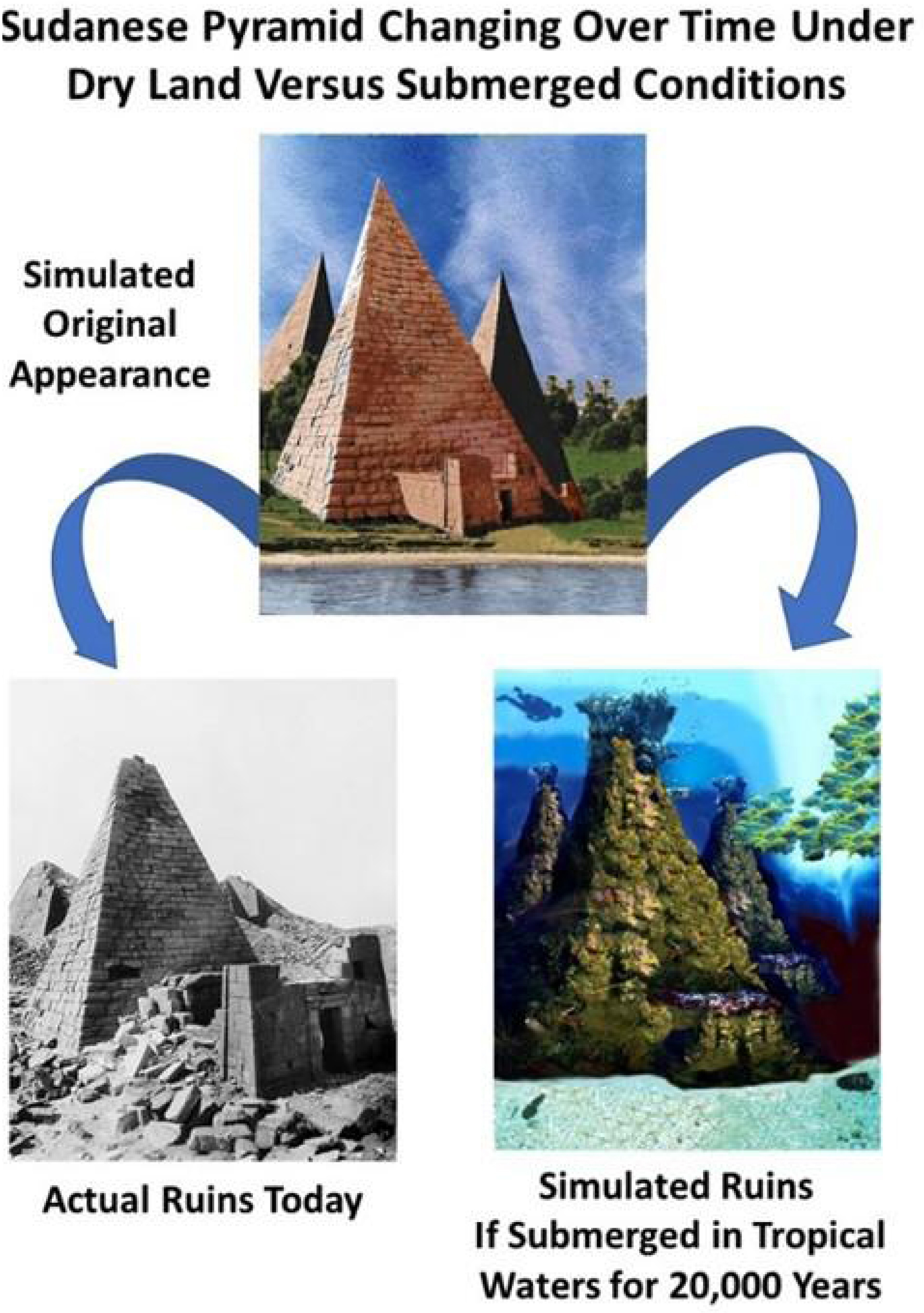
Simulated scenario of a Sudanese pyramid changing over time on dry land versus submerged conditions.
Coral reefs in and around Foul Bay can provide insights into past sea level changes and environmental conditions. Corals are sensitive to changes in water depth, temperature, and salinity, making them excellent indicators of past marine conditions. Uranium-series dating of corals has been used to reconstruct sea levels and provide timelines recording when certain areas were submerged or exposed. Studies by Hoang and Taviani (1991) on coral reefs from uplifted Red Sea islands offer crucial data for validating GIA models and understanding the timing of sea level changes in the region.
Coral reefs must be anchored to a solid substrate such as natural stone, stone masonry, brick, concrete, or previously established coral reef itself. Patch corals, also called platform corals, exist in shallow waters wherever bare substrate provides an anchor, hydrologic and climatic factors support growth to the surface, and sandy bottom surrounds and constrains each reef to its own column. We posit that, if a settlement were to be inundated in Foul Bay, its most likely form would be scattered patch corals, rising from a maximum depth of 125 m to the surface.
In 1998, Dobson proposed that some of the world’s patch coral reefs in shallow tropical seas might overlie stone structures. He purchased a full set of nautical charts for all of the world’s oceans and seas and searched diligently for patch coral reefs in depths of <125 m throughout the latitudinal zone of coral reefs worldwide. Searching the entire World Ocean, he found that Foul Bay conspicuously stood out as the largest concentration of patch coral reefs on earth. His research notes record his very first impression of Foul Bay, “Rocks all over. Some regular geometric patterns in 30 to 64 m of water. Dense. Impressive. No doubt why sailors dubbed it “foul” for shipping. Some formations are straight or slightly curving lines like buildings spaced along a boulevard. Most run parallel to the coast. Most clusters could have been physical or cultural. Long fringing reefs that seem natural are scattered about, interspersed in shallow water. A total count of 306 patch coral reefs.” (Figure 9). See Table S2 in Supplemental Material.
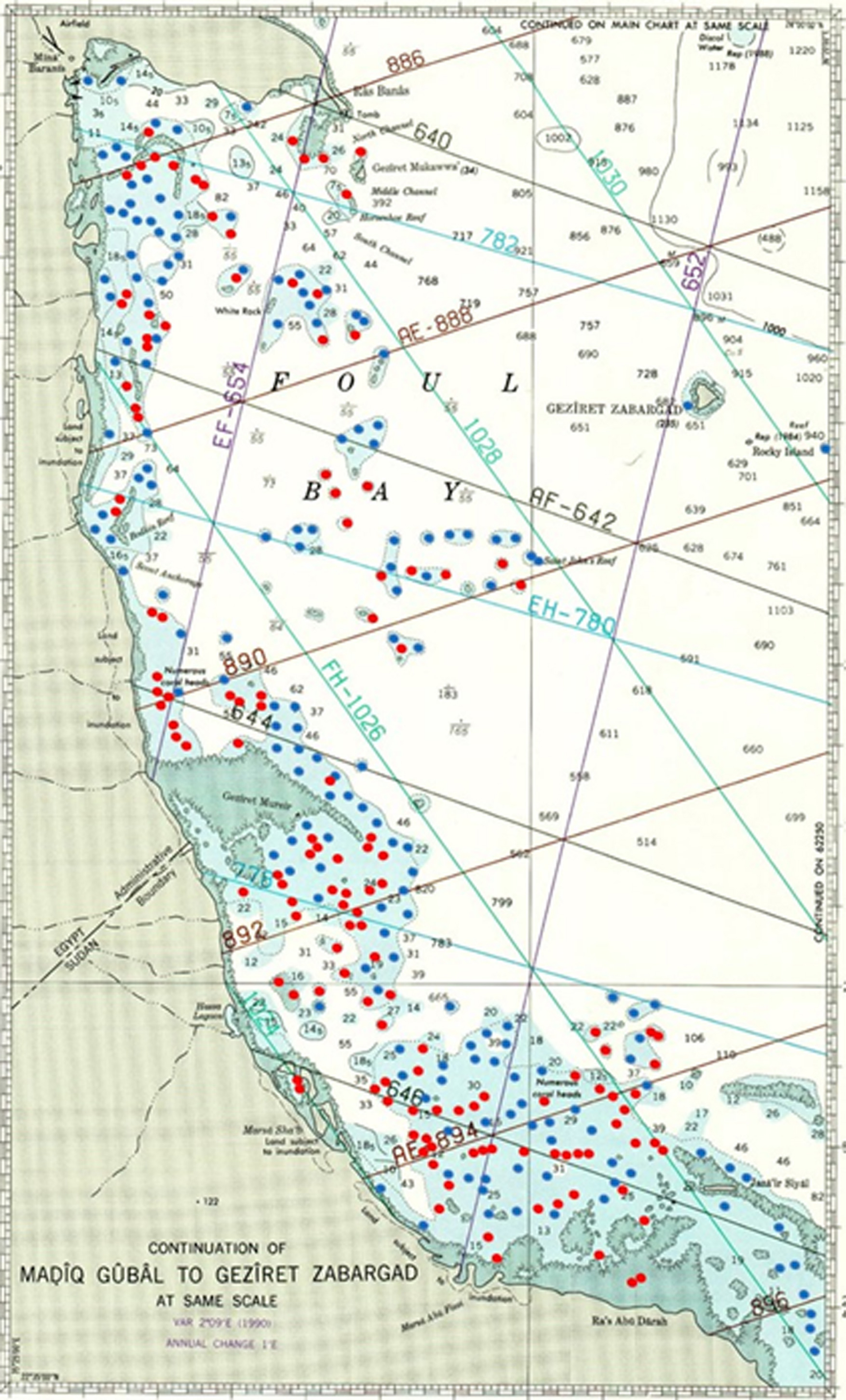
Patch Coral Reefs and Sea Floor Depths in Foul Bay, Egypt. Soundings in meters. (This chart is NOT VALID FOR NAVIGATION, and we have removed all coordinate information so readers will not be tempted to use it that way.) Cartographic Data Source: National Oceanic and Atmospheric Administration, International Hydrographic Charts, Chart #62230, (NOAA, 2013). Cartographic legend is explained in Chart #1 (NOAA and NGA, 2019). Red dots represent rocks which cover and uncover or are awash at low water. Blue dots represent rocks at uncertain depth which are hazardous to navigation even though always covered. Masquer
Patch Coral Reefs and Sea Floor Depths in Foul Bay, Egypt. Soundings in meters. (This chart is NOT VALID FOR NAVIGATION, and we have removed all coordinate information so readers will not be tempted to use it that way.) Cartographic ... Lire la suite
Conditions on the Egyptian Red Sea Coast are ideal for corals (Berumen et al., 2019). Journalists speak in glowing terms of “the last coral refuge” and its “super-corals.” At any given depth, that favorability depends on latitude, wave energy, and turbidity underlain by sufficient solid substrate to anchor reefs. The upward growth of patch coral reefs is measured in terms of vertical accretion of carbonate skeletons from Scleractinia, also called “hard corals” and “stony corals.” Dullo et al. (1996) measured vertical accretion at several depths and sites of Porites colonies in fringing reefs near the Marine Science Station at Aqaba. The rate was 0.67 m/kyr for the last 5 kyr. Braithwaite (1982) studied reefs in the North Towartit and Shambaya Groups of the Sudanese Red Sea.
14. Berenice Aquaterra; crossroads of antiquity?
Retrospective GIA mapping reveals striking possibilities of altered crossings between the Red Sea and Mediterranean Sea. Foul Bay attains a competitive advantage when sea level is low and loses that advantage to the Gulf of Suez when sea level is high. What cannot be ascertained is the level of demand at LGM. Common knowledge and scholarly opinion assume that demand was near zero, but that is an assumption based on terrestrial archaeology. No systematic archaeological survey has been conducted for the now submerged lands that would have been the foundation of coastal commerce at that time. We stipulate that humans were present in the vicinity but do not speculate regarding the number of people residing in subsequently inundated settlements or actively crossing sea to sea in such ancient times. Rather, we advocate a program of exploration and research to determine how many people resided in the region and in Foul Bay when it was dry. Only when that approximation is known with reasonable certainty will it be possible to determine whether Berenice Aquaterra was a few scattered homes, a village, or a major port.
Hypothetically, if the sea levels of 14,000 BP or earlier were to occur today when populations are sizable and mobile, Berenice Aquaterra undoubtedly would become a major port, surpassing cities on the Suez Canal itself since far larger port functions—docking, unloading at one end, transshipment, and loading at the other end—would be necessary for overland crossing. In 2021, the Suez Canal carried a record 1.27 billion tons of cargo on 20,694 vessels and earned $6.3 billion in transit fees. Imagine what the economic impact would be if that cargo and finance passed through two Egyptian cities, Berenice and Aswan, overland between them, and up and down the Nile River. The number of employed longshoremen, alone, would be enormous, not to mention myriad other trades and professions. Transportation infrastructures stretching 300 km from end to end would be built and maintained over multiple routes. Egypt might dominate world transport and possibly world trade.
The keys to Berenice Troglogytica’s success as a settlement and port 2000 years ago depended on two primary factors: its natural, strategic appeal to commercial interests and a demand for port services due to local, regional, and global trade. Likewise, if population and trade had been great enough ten or twenty thousand years earlier, Berenice likely would have been the crossroads of antiquity. Whatever maritime traffic existed between the Red Sea and Mediterranean Sea would have relied heavily on that route. With an overland portage at its back, Foul Bay would have required break-of-bulk that, combined with its unique location, might have encouraged a settlement and perhaps a nascent port.
With sufficient traffic, Berenice Aquaterra could have been an entrepôt, possibly a uniquely important one, in contrast to its relative insignificance today. In geographic terminology, an entrepôt is a principal transshipment location—city, port, or trading post—where goods are imported and exported, stored, and traded. From ancient to modern times, the largest urban settlements on earth have been entrepôts that are “break-of-bulk” points where bulk cargo arrives from overseas and must be divided into smaller loads for transport inland or to smaller settlements on nearby coasts or islands. In the opposite direction, cargo arrives in small loads from the interior and must be aggregated into larger bulk shipments for sailing to foreign ports. New York, London, Sydney, Tokyo, Istanbul, and Cairo are prime examples.
By about 6500 BP sea level had shifted so that the Gulf of Suez route was more efficient in those same measures, and after 1869 CE the Suez Canal eclipsed all other routes. As for demand, Berenice Troglodytica experienced heavy use of its port facilities from 275 BCE to the 6th Century CE including centuries when Berenice Troglodytica was a key stop for goods transported between Egypt and India. By 500 CE demand shifted back to Suez so that Berenice Troglodytica’s port effectively went out of business, and the town itself was lost. By that time, Foul Bay was cluttered with patch corals, then as now an obstacle to navigation.
Kotarba-Morley (2019) proposed parameters of attractiveness designed to compute quantitative scores for site suitability based on sea, land, resources, and socio-economic/political variables. Fortunately for our study, she chose Berenice Troglodytica as her prototype. Her computational model fits within the broad category of screening methods for land use suitability, which can be local, regional, or global in coverage. Screening techniques such as this experienced a huge boost in capability and popularity when geographic information systems (GIS) emerged in the 1970s. Indeed, the first article using GIS in research mode ever to appear in a mainstream geographic journal demonstrated a regional screening procedure for land use suitability analysis. Its application was to select candidate areas for large electrical generating facilities in the U.S. State of Maryland (Dobson, 1979).
Kotarba-Morley (2019) is the leading expert on ancient ports in and around the Red Sea. Her screening algorithm takes the perspective of hypothetical motivators who recognize the need for new ports and proactively seek suitable sites. For the most part, all sites are treated as possessing inherent characteristics that may or may not be of interest to hypothetical developers. Sites passively wait for developers who may or may not appear. In reality, it is more likely that the earliest development at each place began with a single boat sailing into safe harbor, mooring for a short while, and exchanging goods with local residents; the port function then grew with repetition boat by boat, shipper by shipper, and buyer by buyer. Foresight and pro-active assessment would have begun when governments and businesses recognized strategic needs and decided to invest. At that point, port facilities would be added to the matrix and would influence attractiveness along with natural features.
In summary, Kotarba-Morley (ibid.) algorithm judged the Berenice Troglodytica of 275 BCE to 500 CE to be “a practical and a rather attractive location,” rating 2.6 out of 4 (0.65) on all combined measures. Its sea features were “moderately attractive” at 0.72 and its socio-political-economic features were “moderately attractive” to “very attractive” at 0.85. “Berenice is naturally strategically located on top of an uplifted promontory with good all-round views, including the entire Foul Bay and the entrance to a number of surrounding wadis, and this position would have enabled the sending of signals to forts and stations located in the foothills of the mountains. A score of 4 is achieved … not only due to its defensive position and viewshed location, but also because it benefitted from good connections with the hinterland via a number of caravan routes supported by well-positioned and well-defendable stations, forts and praesidia (Bagnall et al., 2001; Sidebotham and Zitterkopf, 1995).” On one measure alone, demand, did Berenice rate a perfect score. Demand initially under the Ptolemies was driven by the need for African elephants and later under the Romans by concern for efficient transshipment of Indian Ocean goods.
How would these scores have changed over the past 30,000 years? Prevailing scholarly opinion today would suggest little demand before 275 BCE and after 500 CE. It is crucial, however, to avoid falling into self-fulfilling projections. If substantial trade existed at LGM, the demand for a port in Foul Bay would have been greater than at any other time in the past 30,000 years, due to its strategic position potentially connecting the Atlantic Ocean/Mediterranean Sea realm with the Red Sea/Indian Ocean/Pacific Ocean realm. If substantial trade existed, Berenice could have been an entrepôt like no other.
Consider, also, that Kotarba-Morley’s glowing assessment of Berenice’s strategic position evoked a period when sea level was almost as high as today. For many thousands of years before, during, and after LGM, low sea level would have reshaped land and water so that Berenice’s overview would have been more strategically advantageous than today, as would its access to the interior. We respectfully suggest that it would be helpful to add one more parameter of attractiveness dedicated to scoring global and regional access from a strategic standpoint.
Procedurally, we hope Kotarba-Morley will share her extensive database of ancient Red Sea ports in a geographic information system (GIS). As Sinclair et al. (2019) say, “In … thirty years and more … archaeological field surveys have been transformed by the availability of satellite imagery, GPS location and GIS mapping to investigate relationships between finds and landscape features.” Beyond mapping per se, GIS emerged as an essential analytical capability for understanding all types of distributions, movements, and flows in precisely the ways that parameters of attractiveness require. What we would like to see most is attractiveness scores for Foul Bay and the Isthmus of Suez compared through 30,000 years of sea level change under a range of population scenarios.
15. Discussion
The implications of sea level change over the past 30,000 years are potentially transformative for archaeologists, anthropologists, evolutionary biologists, historians, geographers, Egyptologists, and other scholars. We asked, for example, how modern humans got from their original home in Africa to their eventual homes in Europe and Asia? Bailey, Meredith-Williams, et al. (2019) state, “Supporting field evidence for or against [a certain] hypothesis of an early coastal dispersal is almost non-existent, arguably because the relevant areas and time periods in question are now submerged below modern sea level.” Are crucial pathways and meeting points now submerged and therefore difficult to investigate? What difference might alternative pathways have made in the prehistoric settling of Egypt and subsequent development of Egyptian cultures? Assessing Greco-Roman ports on the Red Sea, Kotarba-Morley (2019) states, “… beyond brief references in classical texts … Aside from Myos Hormos, Adulis, and Berenike, no other exact and unequivocally confirmed location of an actual harbour within a Classical port town is known.” Did some of those missing ports exist earlier than presently known so that key evidence is now submerged?
We describe and analyze alternative crossings at prehistoric dates with confidence because their physical geographies are based on rigorously measured elevation and bathymetry data and mapped hypsometrically according to retrospective sea level projections that account for global isostasy and are well established in scientific literature. It would be hard to argue against the diminutions of Foul Bay and the Gulf of Suez at the LGM and reappearance later because they are evidence-based and straightforward. However, such dramatic changes in travel distances and directions necessarily imply equally striking possibilities in human geography, archaeology, anthropology, and history, which are far more debatable. We urge all disciplines to consider the impacts of sea level change when studying ancient Egypt. To that end, we make our results available to all in Supplementary Materials.
We contend with confidence that displacements of human migratory routes by >700 km horizontally and >125 m vertically, as found here, would cause transformative changes in human geography. We offer the profusion of patch corals in Foul Bay and the uncertainty of Berenice Troglogytica’s location as mysteries that may shed light on the human geography of Berenice Aquaterra.
Is there any remaining evidence of material culture under Foul Bay? We searched for and found no archeological record of submerged stone structures. However, we discovered that patch corals are extraordinarily abundant in Foul Bay, noted that corals require a solid substrate, and now recommend systematic exploration to determine whether its substrates are natural or constructed.
How reliable is the current understanding of Berenice Troglodytica’s age and location? We discovered and documented a long record of cartographic confusion regarding its precise location on Foul Bay. We posited that such extreme uncertainty favors our Scenario B in which a coastal settlement developed at the LGM and migrated laterally while rising upward. Its precise location over time might well have confounded 19th Century cartographers and other scholars who were unaware of the inundation that had occurred below.
Do current understandings of predynastic Egyptian culture and biological affinities match low-sea-level or high-sea-level pathway configurations? We found that (a) settling first in Upper Egypt and then Middle Egypt and (b) biological affinities among Naqada and al-Badārī and neighboring regions, near and far, favor a low-sea-level pathway configuration.
We also asked if predynastic and prehistoric populations were large enough to create ports and other transportation hubs, but no answers were found in scholarly literature for locations submerged today. Indeed, we found no comprehensive attempts to study the matter.
Following these leads must necessarily question established theory and conventional wisdom regarding ancient Egyptian migration, human settlement, and cultural development, and will, no doubt, generate controversy. It is important to keep in mind that the only audacious aspects of our scenarios are the simultaneous, complementary behaviors of the two waterbodies (Foul Bay and Gulf of Suez), and those interpreted behaviors are firmly founded in standard theory. The true uncertainties are population densities and mobilities at such ancient times, in which case we state our scenarios as hypothetical and caution future researchers against assuming values too high or too low.
The existence of Berenice Aquaterra can be tested only by reconstructing palaeolandscapes and conducting archaeological surveys. Resurgence in this type of research around the world (Europe, North America, Arabia, Australia, and South Africa) makes such vertically integrated investigations a realistic prospect (Bailey, Harff, et al., 2017). McLaren et al. (2020) advocate a stepwise process: (1) create localized sea level curves, (2) generate detailed bare earth digital elevation models, (3) create archaeological predictive models, (4) verify the models using archaeological prospection, and (5) demonstrate that archaeological materials found date to the late Pleistocene. We advocate urgent application of this five-step process to the Suez and Foul Bay crossings.
16. Conclusions
This study constitutes a strategic reassessment of changes in sea level and associated pathways in and out of Africa since 30,000 BP. We retrospectively map sea level fluctuations and their effects on coastal landscapes in the Middle East, especially in terms of likely migration routes. Using an improved Glacial Isostatic Adjustment (GIA) model, we refine the spatial and temporal precision of ocean levels and coastlines from 30,000 BP to the present. We acknowledge uncertainties in the GIA model, particularly regarding ice history reconstructions, earth’s viscosity structure, and bathymetric data. These factors can influence predicted sea levels and shoreline positions, highlighting the need for continued refinement of models and data sources.
Global sea levels fluctuated by 125 m over the past 120,000 years. They reached their lowest level during the LGM about 20,000 years ago, thereby exposing an additional 11.6% of land area globally and significantly enhancing migration and travel opportunities in coastal zones. The research examines the Suez crossing and Foul Bay\Nile River\Mediterranean Sea crossing and considers the Gulf of Aqaba route to the Levant, Bab el Mandab crossing to Saudi Arabia, and Straits of Sicily and Messina. Key findings include:
- Berenice Aquaterra is hypothesized as a crucial port on Foul Bay, based on geographic principles of regional development and analogous archaeology of 2000-year-old Berenice Troglodytica and its transportation infrastructure.
- An unusual profusion of patch coral formations in Foul Bay raises new questions about potential human settlements and warrants further exploration.
- Uncertainty in cartographic representation of Berenice Troglodytica’s location fits a proposed inundation scenario well enough to encourage exploration of Foul Bay and the patch coral formations in it.
- The study indicates south-to-north and east-to-west directions of sequent occupance in the Nile Valley, challenging conventional wisdom about ancient Egyptian migration patterns.
The methodology integrates DNA evidence, archaeological literature, and retrospective GIA mapping to reconstruct past landscapes, providing insights into ancient human migrations and settlements. This multidisciplinary approach offers a robust framework for understanding human geography, especially historical mobility and maritime networks. The authors emphasize the importance of investigating Foul Bay’s paleogeography and underwater archaeological remains, suggesting that such research could provide transformative insights.
This study demonstrates the significant impact of sea level changes on human migration patterns and coastal settlements during the late Pleistocene and early Holocene. It underscores the value of integrating geophysical modeling with archaeological and genetic evidence to enhance collective understanding of human prehistory. The findings open new avenues for exploration and research, particularly in submerged coastal areas, and enhance existing narratives about human migrations out of Africa.
Declaration of interests
The authors do not work for, advise, own shares in, or receive funds from any organization that could benefit from this article, and have declared no affiliations other than their research organizations.
Acknowledgments
We sincerely thank Donald W. Jones, Adjunct Professor, Department of Classics, University of Tennessee, Knoxville; Martin J. Pasqualetti, Arizona State University; Geoff N. Bailey, University of York; and James A. Harrell, University of Toledo (retired) for reviewing early drafts of our manuscript and offering solid advice. Harrell was especially helpful in apprising us of literature and findings at the Berenike excavation site. Bailey did the same for many major Red Sea sites. Extensive conversations with Bailey and Harrell explored the sensitive interface between archeology and our disciplines. We deeply appreciate the cordial and professional manner in which François Chabaux, co-editor-in-chief of Comptes Rendus Geoscience, and three anonymous reviewers evaluated our research and improved it tremendously with their expert knowledge of the diverse topics necessarily involved in age-old mysteries of place, time, and human behavior. Figures showing the results of our GIA model have been drawn using the Generic Mapping Tools (GMT) of Wessel and Smith (1998). The Sea-Level Equation solver can be downloaded from: https://gmd.copernicus.org/articles/12/5055/2019/gmd-12-5055-2019.html. GS is funded by an RFO grant of DIFA. We deeply appreciate the dedicated assistance of Marcy Bidney and her staff at the American Geographical Society Library in Milwaukee, Wisconsin and the exceptional efforts of Greg March (University of Tennessee Map Library) to provide the nautical chart behind Figure 9. Jeffrey R. Dobson, Robert B. Honea, and Robert G. Lipscomb are appreciated for their abiding input to the conception and vetting of the ideas presented in this paper.
1 The word “occupance” has a long tradition of use in settlement geography. While “occupy” or “occupancy” can be momentary, “occupance” implies a long term act of settling. “Sequent occupance” implies a succession of occupants over seasons, years, centuries, or millennia. (https://www.merriam-webster.com/dictionary/occupance).