


 CC-BY 4.0
1. Introduction
Earthquakes occur as main-shock/aftershocks sequences, and in some cases, as seismic swarms. The latter corresponds to an increase of many small earthquakes clustered in time and space, without a clear onset and main event. Apart from those triggered by human activity, it is usually thought that swarms can be triggered by fluid pressure or by aseismic sliding [e.g., Vidale and Shearer 2006; Roland and McGuire 2009; Chen et al. 2012; Duverger et al. 2015]. These two processes can be distinguished through the migration velocities of events within the swarm, from a few m/day rate for fluid-triggered events to several m/hour rate for aseismic events [Shapiro et al. 1997; Lohman and McGuire 2007; Shelly et al. 2013]. Consequently, this distinction requires precise data and location of the events. Fluid injection experiments [De Barros et al. 2018; Cappa et al. 2019] and natural earthquake swarms analysis [De Barros et al. 2019, 2020; Hatch et al. 2020] have shown the possible interaction between fluid-induced and aseismic deformation-induced migration, characterizing the ambiguity of the mechanisms underlying the origin of the swarms and their unpredictability.
Swarms can stop on their own or evolve into a larger earthquake, as has been post-confirmed a posteriori as the cause of the 2009 L’Aquila (Italy) Mw6.3 earthquake [Chiarabba et al. 2009; Chiaraluce et al. 2011]. Compared to main-shock/aftershocks sequences, long swarm sequences of low to moderate seismic events (some of which are felt by the public) raise questions about crisis management over such long periods of time, especially in moderate seismic prone regions. In addition, swarms are not known to be markers of change in long-term regional seismic hazard, but complex seismic/aseismic processes may need to be considered in assessing local seismic hazard [e.g., Cheloni et al. 2017].
Swarms are observed in different contexts, such as in regions with a low rate of tectonic deformation [Thouvenot et al. 2009; Jenatton et al. 2007; Hainzl 2004], like the French Alps. The Alpine region is considered one of the most seismically active areas in France [Drouet et al. 2020]. There is a background seismic activity, but some areas have recurrent and historically observed swarms. For aftershocks and swarm sequences, the underlying physical processes may be different but once the sequences have begun, the same key issues are addressed by the public and local authorities for risk management: What will be the duration of the sequence? What may be the maximum magnitude of the sequence? What may be the expected ground motion and consequences on structures and infrastructures? These questions also arise in a post-L’Aquila context where the trial of the Italian scientists [Alexander 2014; Scotti 2014] imposes caution on seismologists in charge of seismic monitoring regarding the dissemination of information in such uncertain situations.
In this paper, we analyze a prolific 3 years long (between 2017 and 2019) seismic swarm sequence in the Maurienne valley (north western French Alps, Savoie department). Located in a region where no local instrumental seismic activity had been observed for 30 years, it triggered many process-related scientific questions. Furthermore, an operational question on the positioning of scientists for the management of information to authorities and populations, considering the French frame for natural hazards management, has to be discussed. Strongly felt by the population and its suddenness, compared to past seismicity, the urgency and duration of the sequence provided interesting feedback, especially in a context of moderate seismicity like France. In the alpine tectonic context of the swarm region (i.e., in the External Crystalline Massif ECM of Belledonne), the operational management of the sequence by the observation services SISmalp from Université Grenoble Alpes is described in this paper. In addition, the relocation of events and the characterization of the focal mechanisms highlight the fault involved in the triggering of the swarm and bring information on the activated process. Finally, the operational sequence provides the analysis of interactions between scientists and risk managers, pointing out some avenues for improvements elaborated with local authorities.
2. Tectonic and geological context
The swarm is located in the south flank of the Lauzière massif, north part of the Belledonne massif (Figure 1). It corresponds to one of the Paleozoic outer crystalline massifs of the French western Alps and extends over more than 120 km in a N30 direction. This external crystalline massif (ECM) presents reliefs, which locally reach more than 3000 m: this massif belongs to the same geological unit as the Mont Blanc in the north or the Ecrins–Pelvoux in the south. This massif is limited to the west by the large topographic depression of the Isère valley and is crosscut by Arc and Isère rivers with a nearly N–S direction (Figure 1).
Tectonic sketch and simplified geological map of the study area draped on the DEM (RGE Alti IGN). Adapted from Thouvenot et al. [2003], Antoine et al. [1983], Chiron and Kerrien [1980], Debelmas et al. [1979]. Reddish color: External crystalline massif (light reddish with gray lines: western micaschist; reddish: internal mafic rocks); light blue, Mesozoic and Cenozoic cover. Blank: Internal zones (horizontal gray line) are thrust over the Eocene Flysch (dots from different size on blank); Blue line: major rivers and lakes. White rectangle corresponds to Figure 3 and Maurienne Swarm area. The BBF [Thouvenot et al. 2003] is represented only in its south part where it matches with geological features.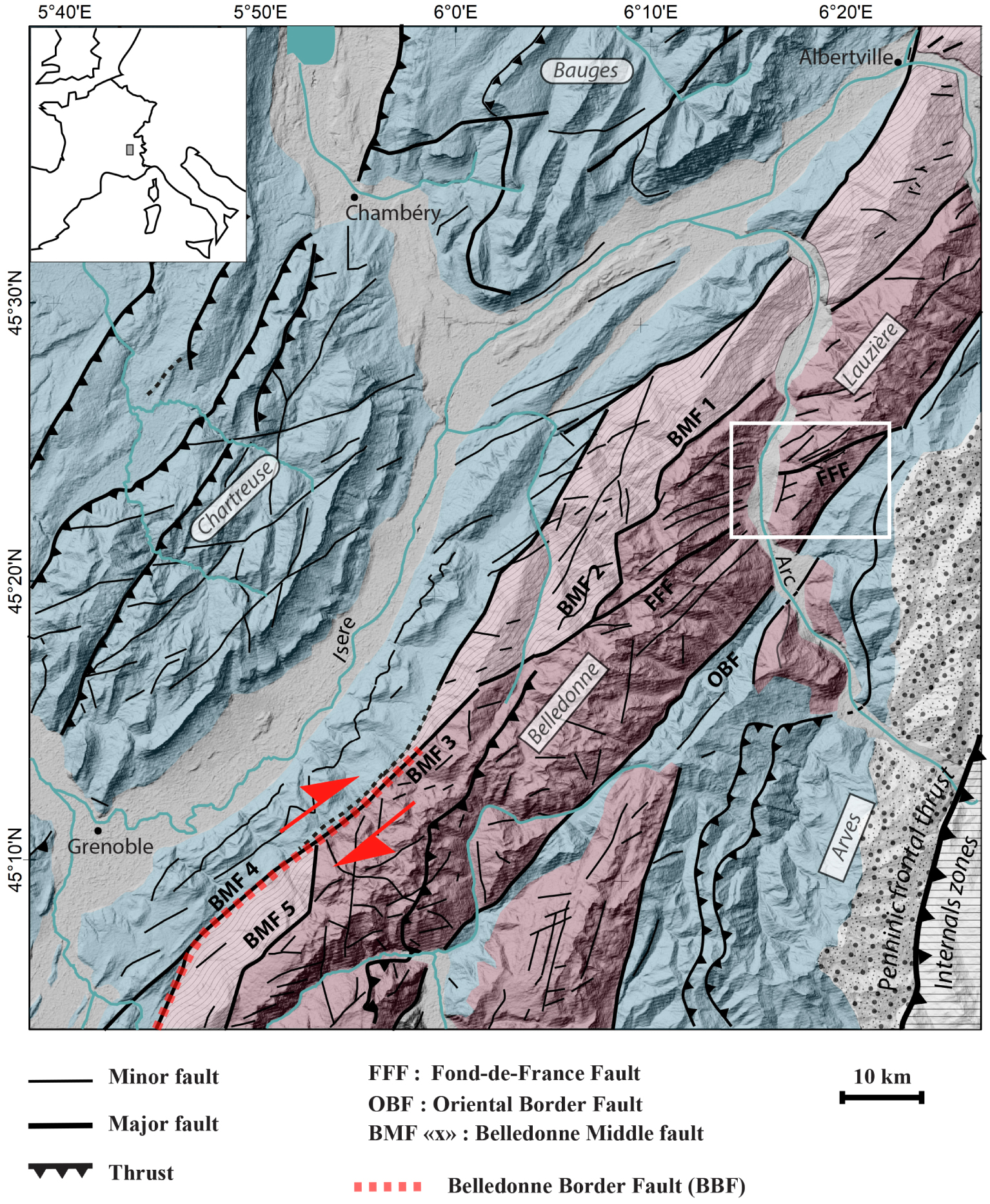
The lithologies that constitute the massif bear witness to an important structuring acquired during the Hercynian orogeny and re-activated in Alpine shortening. The bedrock is composed of a varied association of metamorphic rocks from Precambrian to Carboniferous age, structured during the Hercynian cycle [Guillot et al. 2009]. This basement is unconformably overlain by sediments deposits from Triassic to middle Jurassic of varying thickness (up to 10 km) result from a phase of extension that is located on the large faults inherited from the Hercynian orogeny. This phase of extension leads to the east to an oceanization in the late Jurassic and Cretaceous while in the west (future Belledonne Lauzière massif), post-rifting deposits recovered the area [see Dumont et al. 2011 and references in there for details].
Considering the propagation of the Alpine deformation [Dumont et al. 2012 and references in there] since the early Oligocene (34 Ma), the Alpine crustal scale shortening affects the Belledonne ECM massif. The shortening generated the exhumation of the area using inherited structures, while part of its Mesozoic sedimentary cover was deformed and partially to totally eroded. Quaternary deposits in local depression and large valley attest the extension of several glaciers in the area during glacial period since 1 Ma [Antoine et al. 1983]. In Maurienne Valley, the Arc glacier reaches 1800 m asl close to the swarm location. Some recent scarps outcropping in the ECM mainly close to the BMF (west side of the Arc river, Figure 1) has been identified as gravitational sackungs [Hippolyte et al. 2006; Le Roux et al. 2009]. As the authors show, these kilometers scale recent scarp with pure normal motion are linked with gravitational movement. They must be triggered by a debuttressing process controlled by glacial retreat and gravity but are distinct from “real” active tectonic features.
If the actual horizontal velocity deduced from GPS [Nocquet et al. 2016] is very low in the western Alps, the exhumation [nearly 2 mm/yr in the study area, Sternai et al. 2019] points out the active tectonic context. The Belledonne Massif is today affected by recurrent active deformation, demonstrated by historical seismicity [Wilhelm et al. 2016] and recently acquired seismic monitoring from 1989 to 2000 [Thouvenot et al. 2003] and geodetic data [Walpersdorf et al. 2015]. The location of the seismic sources, ensured for more than 35 years by the seismological network of SISmalp (ISTerre-OSUG,Grenoble Alpes University: https://sismalp.osug.fr/) shows a concentration of earthquakes along an axis parallel to the western edge of the massif, between the Belledonne massif and the Isère valley [Thouvenot et al. 2003]. This alignment of seismic events of ML magnitude less than 3.5 and located at shallow depths (less than 10 km) extends over more than 50 km. The focal solutions reveal a dextral seismo-tectonic regime. This seismic activity is interpreted as the seismic signature of the tectonic activity of the Belledonne border fault (BBF). Thouvenot et al. [2003] assume (with few instrumental seismicity in this part) that the BBF split to north direction and crosscut the Isère valley and reach further south the Bauges subalpine massif. This assumption implies that BBF have no more like with the Belledonne Middle Fault (BMF) system. The global kinematic of the area [Delacou et al. 2004] and recent studies of global geodynamics of the western Alps [Mathey et al. 2020] disapprove this hypothesis. This fault segment (in red in Figure 1), where seismicity and geological structure match is now recognized as potential seismogenic fault [Mazzotti et al. 2020] and is referenced in the French active fault database (BDFA) for seismic hazard assessment [Jomard et al. 2017].
However, this dextral strike-slip fault has never been observed directly at the surface by geological or morphological observations (no more than other active fault in the area). Close to Grenoble, the dextral BBF seems to be linked with old structure: the south part (and one of the south segment) of the Belledonne Middle Fault [BMF, Thouvenot et al. 2003; Le Roux et al. 2010], but more north in Belledonne massif and close to the Maurienne swarm, the situation between actual/historical seismicity and tectonic features are still unclear. The swarm seems to be close to the Lauzière massif Fond de France Fault system (FFF), a segment which affects the south flank of the Lauzière Massif. The FFF is linked toward the south-west to the BMF system not far from the place where seismic activities and tectonic features mismatch toward the north (Figure 1).
Compared to others swarms in the French Alps, the Maurienne swarm is comparable to Vallorcine swarm in the Mont Blanc ECM [Cara et al. 2017] in terms of tectonic and geological position: not far from old hercynian structures and alpine reworked that are clearly visible on the surface in the ECM. The Ubaye swarm [De Barros et al. 2019] affects faults that are inherited but in a higher structural position: in the sediments and nappes covering the ECM eastward of the Penninic frontal thrust. However, the Ubaye swarm occurred between 4 and 10 km depth, located in the crystalline basement. These three swarms are located in the most active seismic zones of the western French Alps [Drouet et al. 2020].
3. Operational monitoring of the seismic sequence of the Maurienne swarm
Since 1985, the monitoring of the seismic activity in the northern part of the French Alps has been operated by the SISmalp service from the Institute of Earth Science (ISTerre-OSUG) of the Université Grenoble Alpes. The original phase of the network building, over 1985–2010, consisted of a network of about 50 short-period sensitive velocimeters, in triggered mode designed for the fine detection of seismicity in the Alps. This first period made it possible to characterize the fine seismicity of the northern Alps in relation to the active faults and in particular in the region concerned by this study, where a very weak seismic rate since 1985 (Figure 2) has been observed (e.g., one M > 1/yr; one M > 2/10 yrs). Over this period, accelerometric stations from the national strong motion networks [Péquegnat et al. 2008, FDSN code: RA; RESIF-RAP 1995] were gradually added to the SISmalp regional network.
Seismic activity recorded by SISmalp [1989–2013]—right panel shows the annual exceedance rate for the Maurienne region (red square) and bottom panel the time distribution of magnitude in the same area.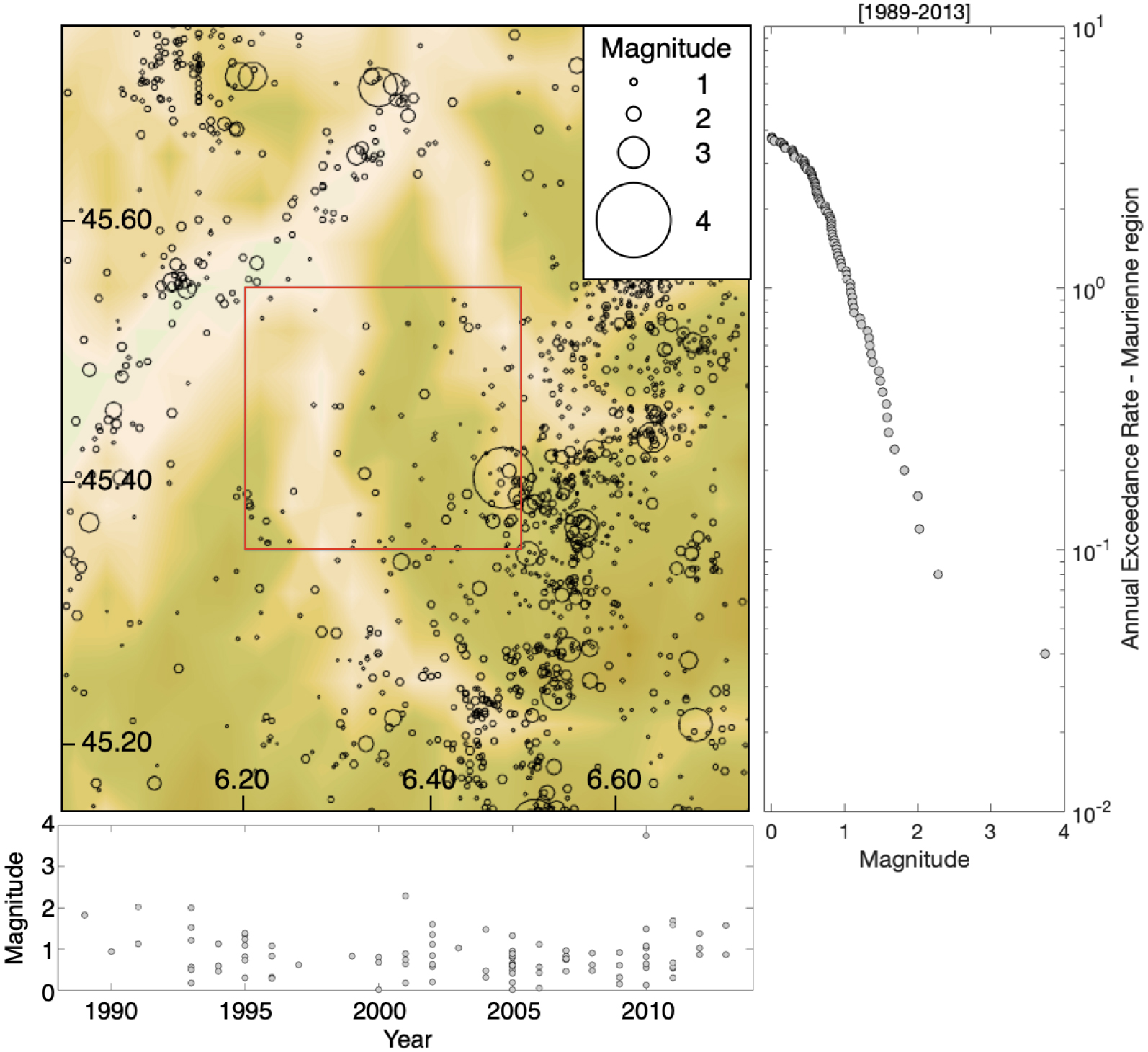
At the beginning of 2010, at the initiative of the ISTerre-OSUG team, the upgrading of the network was launched, the first step of the Résif–Epos project (Réseau sismologique et géodésique français—French seismological and geodetical network; FDSN code: FR; RESIF-RLBP 1995) with the objective of bringing together in a research infrastructure all the national and regional networks (such as SISmalp) and mobile station pool in France [Péquegnat et al. 2021]. Over this period, efforts have focused both on the upgrading of recording sites, related to the quality of the site [Langlais et al. 2013] and the real time and continuous data management through seedlink protocols, and the use of Seiscomp3 software [Weber et al. 2007] for the processing and automatic detection of earthquakes. As of 2016, SISmalp covered all the instrumented sites managed by ISTerre-OSUG for Earth observatory in the northern Alps, including broadband and accelerometric stations (Figure 3).
Map of the active stations (temporary network Z3; permanent networks RA and FR) used for detection and location of epicenters at the beginning of the Maurienne seismic swarm in 2017. The red square represents the location of the seismic swarm (zoom Figure 4). Legend at each symbol is the station name.
During the 2014–mid-2017 period, the permanent stations operated by SISmalp have detected unprecedented seismic activity in the La Chapelle village in the Maurienne valley (Figure 4). Over this time, 208 earthquakes were detected, with a maximum local magnitude ML of 2.5. In October 2016, a stronger seismic activity in the area was detected and also felt by the local population, especially on October 13 (5 earthquakes, 1.2 < ML < 2.1) and October 24 (7 earthquakes, 1.3 < ML < 2.2) 2016. At that time, the mayor of La Chapelle contacted the regional service in charge of natural hazards (i.e., Prefecture de Savoie), relaying his concerns and those of the inhabitants about “the many small tremors felt on October 13 and 24, 2016”. SISmalp had also been questioned on this subject by the Prefecture de Savoie, in order to provide quantitative information on the events detected by SISmalp.
The Maurienne Seismic swarm activity [2015–2020]. Black symbols in the small windows correspond to epicenters prior or after the period covered by the seismic swarm. Red triangles are the YW post-seismic stations, the green one is the Z3.A181A Alparray station.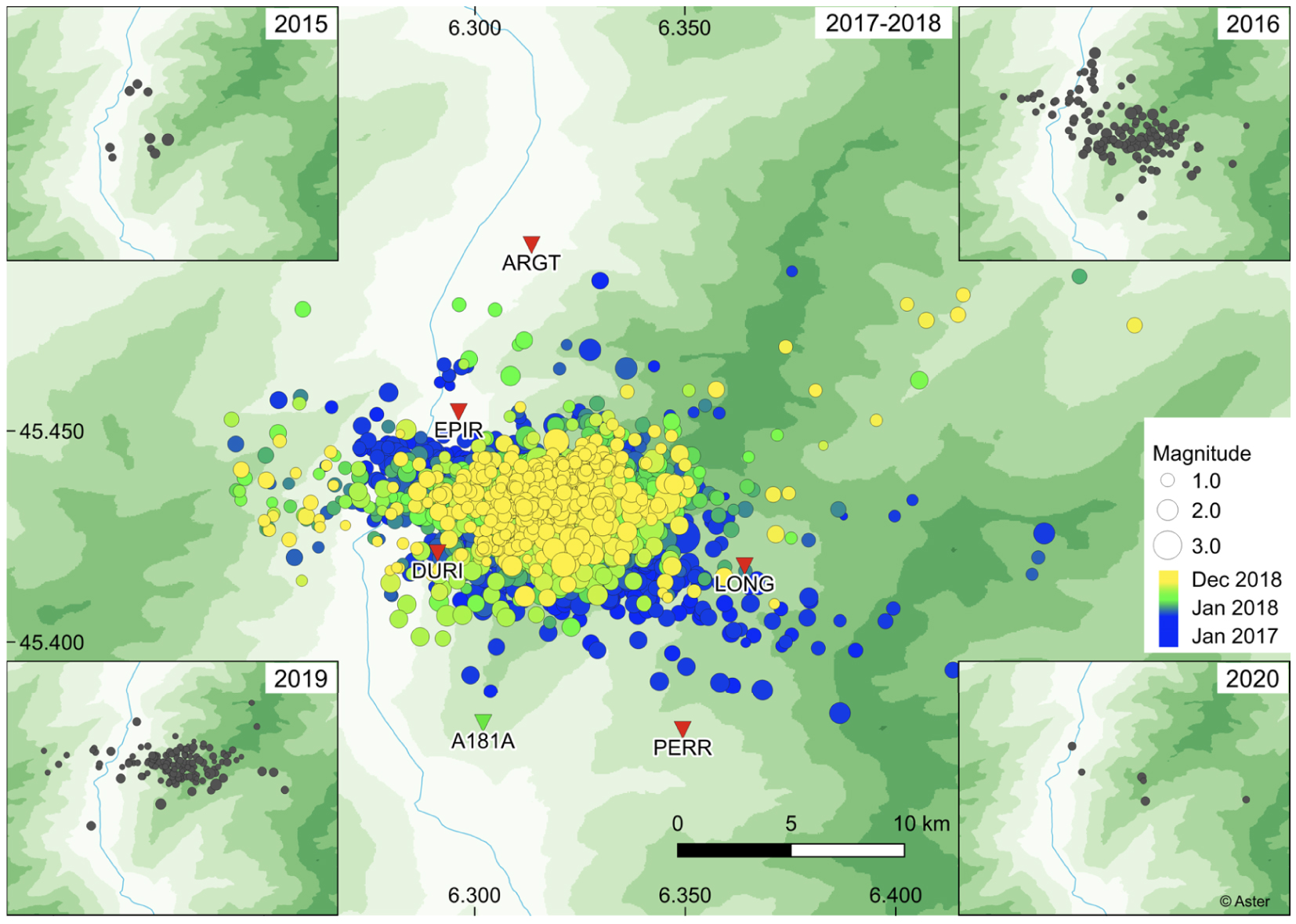
Activity in the area then decreased and remained low until late July/early August 2017. At this date, a second sequence of events located in the same area was detected, including shocks felt by the local population on July 31 and August 1, with the strongest event (ML = 2.3) on July 31 at 21:40 UTC. During the months of July, August, and September 2017, seismic activity remained fairly low, with, however, a constant increase in the number of earthquakes (July 2017: 12 earthquakes, August 2017: 61 earthquakes, September 2017: 113 earthquakes). On October 17 and 18, 2017, two events of ML 2.9 and 3.1, respectively, occurred, causing concern to the population and authorities, followed by a significant increase in background seismic activity. At that time, the SISmalp team decided to deploy temporary stations on the site (Figure 4).
While before October 2017, the earthquakes were localized by the permanent SISmalp stations, five new temporary stations allowed to refine the solutions on the swarm after this date (Figure 4). Installed in two days, all stations were equipped with CMG-40 medium-band sensors and Taurus digital acquisition stations belonging to the RESIF–SISMOB mobile pool [Sismob 2021]. Each station was equipped with 3G modems to monitor the sequence in real time and to access the data continuously, integrating them into the Seiscomp instance. The instrumented sites were identified in two days in five villages with the help of the local authorities (Figure 4): Argentine (station code ARGT), La Chapelle (station code DURI), Epierre (station code EPIR), Saint François Longchamps (station code LONG) and Montaimont (station code PERR). The temporary network became complete on Thursday 26, October 2017. The network code assigned by the FDSN is YW [Guéguen et al. 2017]. The instrumented sites were selected according to the first locations of the events, and strongly dependent on the security of the instruments, the level of anthropic noise, the geological features of the site and the possibility of access to 3G transmission allowing the seedlink protocol. For the stations EPIR, DURI, and PERR, the sensor was buried in the ground, placed on a small concrete slab to ensure leveling, plugged to ensure coupling. The two other stations (ARGT and LONG) were installed on concrete slabs in public buildings. It should also be noted that within the framework of the AlpArray project [network code FDSN Z3, AlpArray 2015], a station (station code A181A) has been installed since December 2016 nearby the swarm area, integrated since this date to the Seiscomp3 instance of SISmalp and allowing to constrain the detection solutions (Figure 4).
After October 2017, the activity of the Maurienne seismic swarm has been monitored via the Seiscomp3 instance with the temporary stations (Z3.A181A and YW) and the velocimeter (FDSN code FR) and accelerometer (FDSN code RA) stations of the permanent network managed by SISmalp. Due to the automatic filtering of the detection in the Seiscomp3 process (which rejects some “noisy” events), and a configuration of the system to avoid too many fake events, Seiscomp3 needs in our configuration at least six validated phases to find a solution to this event. This was a limitation in our case study (small aperture of the network around the swarm) to detect small events. To perform this automatic process, a simple script was added that analyzed the detections made by Seiscomp3, and creates a “manual” event when more than three detections on different stations were found for the YW and Z3.A181A stations. This allows, during the swarm, to find each day several “undetected automatically” events. This method is not as powerful as more proven methods such as, for example, the template-matching methods, currently applied to all continuous streams of temporary and permanent stations [Minetto et al. 2020, 2021]. However, this method is automatically integrated into the operational seismicity monitoring system conducted by SISmalp.
A total of 5744 seismic events located by Seisomp3 were detected and located between 2015 and 2020, with 5201 events between October 2017 and December 2018 (Figure 5). In October 2019, the YW network was de-installed. This decision was taken due to the steady decrease in seismic activity since November 2018 (Figure 5). The number of events remained below ten events per month during the six months prior to the de-installation. AlpArray station Z3.A181A was maintained until June 2020 and confirmed this low seismic activity. During 2020, only five events were detected in the Maurienne swarm area (ML between 0.8 and 1.6). The magnitudes of completeness of the catalog and the cumulative distribution of the magnitude are given in Figure 5b, computed following the maximum likelihood estimation-based method proposed by Ogata and Katsura [1993]. Before and after the installation of the temporary network, mc are 1.635 and 0.871, respectively. However, we do not observe a clear variation of the b-values in time, also confirmed by Minetto et al. [2020, 2021] using a high resolution catalog obtained by template matching. The maximal magnitude recorded during the swarm activity is 3.8 on Friday 27, October 2017.
The Maurienne seismic swarm activity. (a) Histogram of the detected events from Seiscomp3 over the period 2016–2020. The peak of the activity was recorded during November 2017. (b) Magnitude-frequency distribution considering the Maurienne catalog (2016–2020) (panel a) before and after the installation of the temporary network, estimated following the method proposed by Ogata and Katsura [1993]. cdf: cumulative distribution function. pdf: probability density function.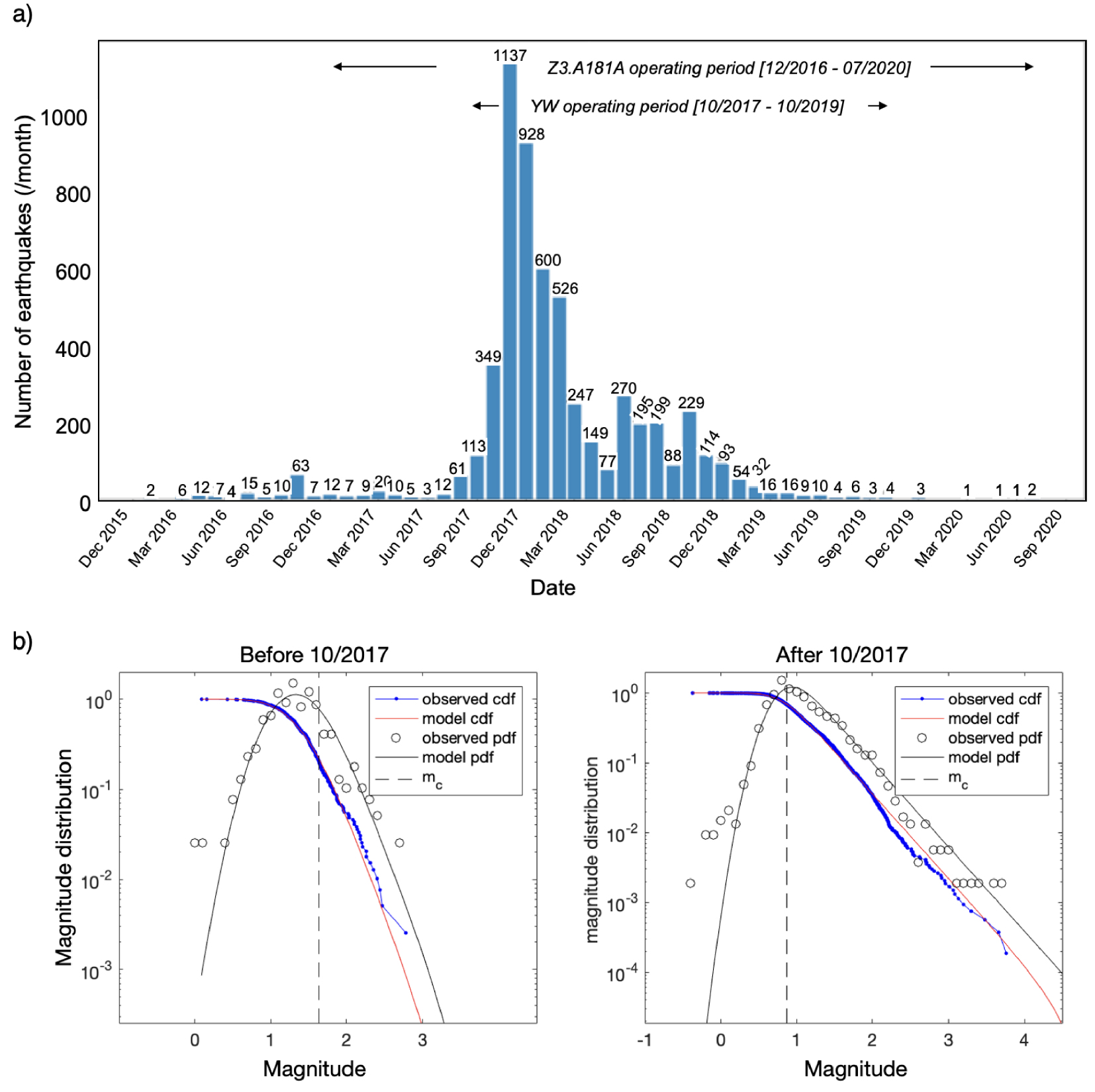
4. Preliminary treatment in an operational context
At the beginning of the sequence, the requests from the local authorities and the worried population motivated SISmalp to propose a fast and operational solution for the location of seismic events, beyond the simple location carried out by the Seiscomp instance (Figure 6). Several actions were undertaken in the framework of the SISM@LP-Swarm project (https://www.isterre.fr/philippe-gueguen/sism-lp-swarm-1336/) focused on the understanding of the seismic swarm processes and sharing with the local exposed authorities on their cross-interaction with scientists during the crisis. Only the actions carried out in an operational framework of daily seismic monitoring are presented here, the other studies being developed in further research activities.
Location of the earthquakes along a north–south cross-section (a) from classical Seiscomp3 instance running at SISmalp, (b) using relocation with HypoDD; (c) using relocation and clustering process. (d) Plan view of the epicenters. The size of the symbol corresponds to the magnitude of the events. (e) Relative error in east–west, north–south and in depth of the hypocenters after relocation and clustering process. Note that these errors correspond to the errors of the reference event of each cluster.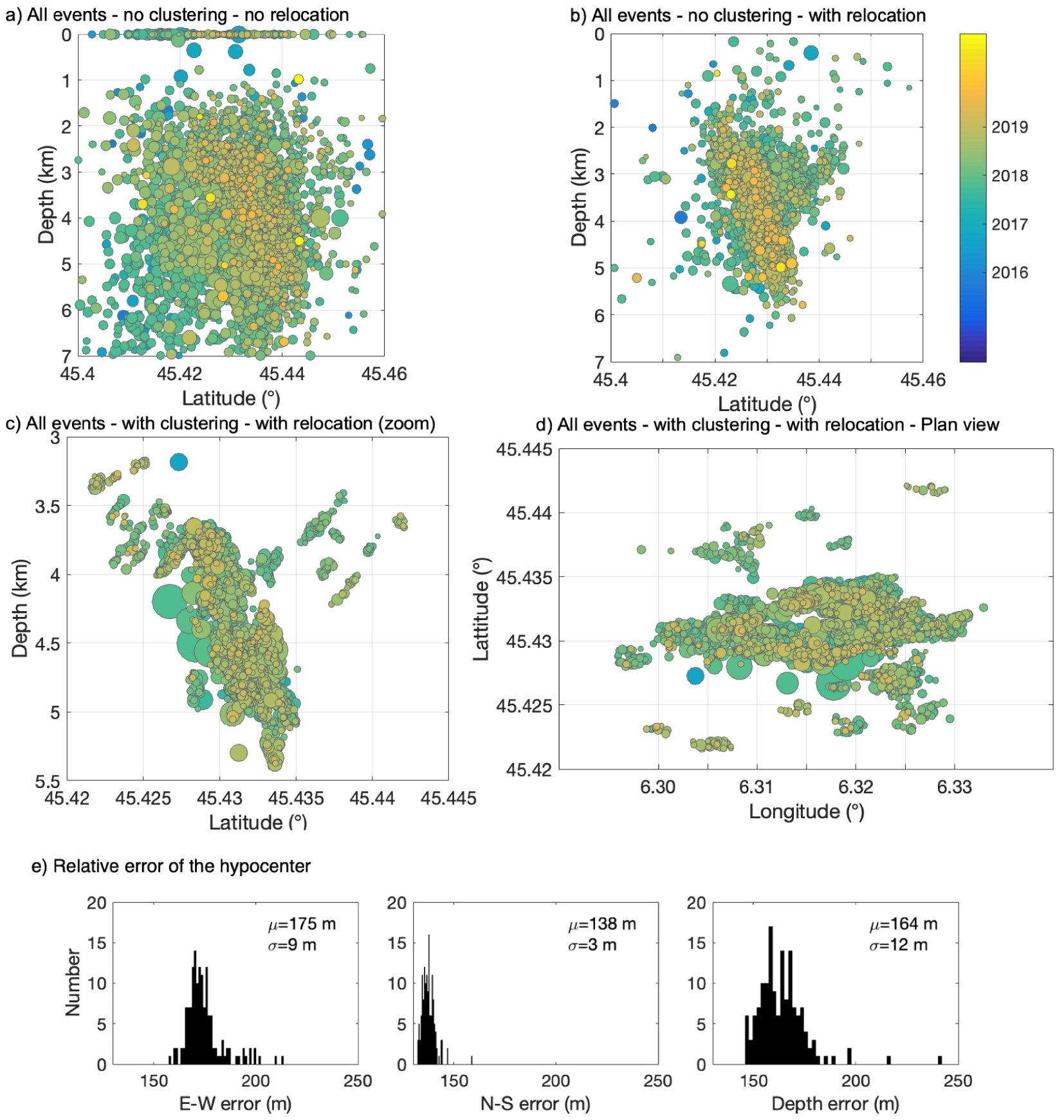
4.1. Relocation of the earthquakes
Events detected and located by Seisomp3 were first analyzed to build events clusters (Figure 6). For that, we calculated the cross-correlation for each pair of events using waveforms recorded at station Z3.A181A. When a pair of events had a high cross-correlation coefficient (0.9 or higher), they were assigned to the same cluster. 5257 events (i.e., 92% of the Seiscomp3 original catalog) were assigned to one of the 157 clusters defined with four or more events. The largest cluster consisted of 663 events. Events in all clusters with ten or more events were relocated using hypoDD [Waldhauser and Ellsworth 2000], based on a double-difference algorithm (Figure 6c). A total of 99 clusters and 4759 events were then relocated, corresponding to 83% of the original catalog). A set of events were not relocated because (1) occurred before the installation of the temporary YW network, (2) not attributed to a cluster (low signal-to-noise ratio, or isolated event) or (3) assigned to a cluster with a too small number of events to be relocated.
The relocation with hypoDD was done in two steps. The first step allowed the relocation of a set of events consisting of one reference event per cluster, using the phases chosen in Seiscomp3. It also included some largest events not assigned to a cluster. The second step made it possible to relocate the events within each cluster: we used a cross-correlation to find the P and S arrivals of all the events, based on the P and S phases of the Seisomp3 for a reference event. The differential times P and S between pairs of events were produced cluster by cluster, and used as input data for the hypoDD. The entire cluster was then shifted, if necessary, so that the position of the reference event matched the position found in the first relocation step. It is worth mentioning that the hypoDD makes a strong assumption considering all travel time anomalies as changes in source position. Some of these travel time anomalies might be due to velocity variations in the source area of the cluster, either in space or in time. It is also assumed that the path of rays between a source and a station is similar for a pair of sources, so that velocity differences along the path are negligible.
1D velocity model used with HypoDD (depth means the depth of the top layer with the velocity Vp)
| Depth (km) | − 1 | 0 | 2 | 3 | 4 | 5 | 6 | 10 |
| Vp (km⋅s) | 4.00 | 4.50 | 4.75 | 5.00 | 5.15 | 5.30 | 5.50 | 5.70 |
The 1D velocity model used with hypoDD is given in Table 1. In this model, derived from local earthquake tomography of the south-west Alps [Paul et al. 2001] and implemented since in the SeiscomP3 tools, it is assumed a constant Vp∕Vs ratio set to 1.73.
Relocating events by clustering allowed producing a more accurate time delays by P and S correlation. In addition, hypoDD also produces more accurate results when relocating a set of events with sources close to each other. For these two reasons, Figures 6c and d show the benefit of the process applied to the Maurienne seismic swarm data. The dispersion of the relocated hypocenters is small and we observe that relocated events for each cluster tend to align along a number of coherent structures. The errors of hypocenter location of the reference event of each cluster are given in Figure 6e. Errors are less than 200 m, much more dispersed along the vertical axis. The errors computed with HypoDD can be underestimated for clusters with more than 100 events [Waldhauser and Ellsworth 2000] but other estimation by bootstrap method [Minetto et al. 2021] are with the same order of magnitude.
Hypocenters of earthquake in cluster 8 (the largest cluster) as function of time (color scale) along a north–south cross-section. The size of symbols corresponds to magnitude.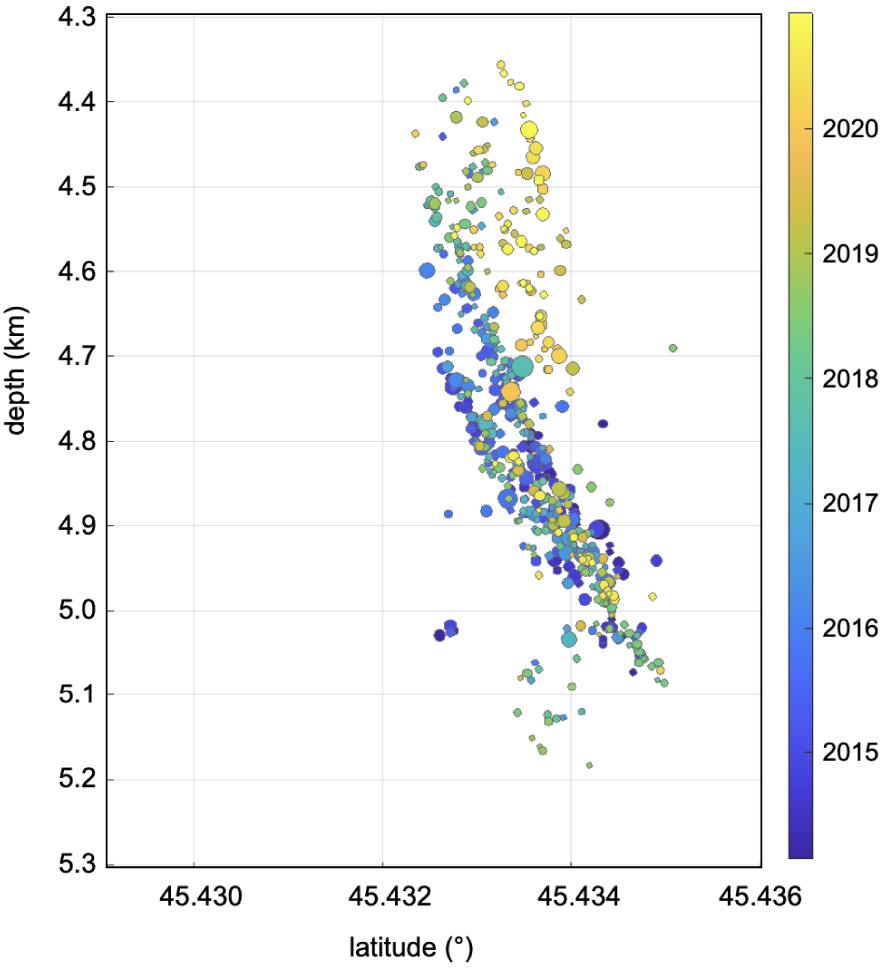
The current seismicity swarm observed in the Lauzière massif is located more inside the Massif (slightly east of the median syncline) compared to BBF–BMF activity close to Grenoble [Thouvenot et al. 2003]. The surface geological observations show in the epicentral zone major faults inherited from the Hercynian oriented N120, and having replayed during the convergence and the recent uplift. The N60 faults are less visible and seem (on the surface) to cut the Lauzière massif along many small faults quite visible on the edge oriented like the fault.
A first preliminary analysis of the spatio-temporal distribution on the relocated data is given in Figure 7, considering the largest cluster (#8), classified in time (color scale), and represented as a function of their magnitude (symbol size). We observe a slight migration of events as a function of depth, from 4.9 km to 4.4 km. The accuracy of hypocenter remains a debate, but the hypoDD relocation per cluster allows to have a relative accuracy between events. Discussion on the accuracy of the absolute and relative location of earthquakes must be improved through, for example, bootstrap analysis in order to valid the splitting into several parallel sub-faults toward the northern parts of the swarm. Moreover, further analyses will be carried out, both on the exploration of continuous data by Template Matching [Minetto et al. 2020], and the analysis of the processes at the origin of the swarm triggering through the calculation of spatio-temporal migration rates.
4.2. Focal mechanisms
To complete the information produced by relocating events, focal mechanisms were calculated for large events. We used the IRIS focmec package [Snoke et al. 1984] for the 41 largest events (magnitude higher or equal to 2.4). Inputs used for the calculations were source parameters produced by hypoDD (incidence angle and azimuth), and polarities observed for the P, SH, and SV components at stations located within 50 kms from the source, including temporary and permanent stations. Figure 8 shows the focal mechanisms in map. Most of those 41 events belong to one of two families of mechanisms: N120 (strike of the rupture plane) normal mechanisms (17 events) and N60 strike-slip mechanisms (18 events). No clear pattern was observed between mechanism type and either event location within the swarm or event date.
Focal mechanisms of the largest magnitude events. Swarm earthquakes after clustering and relocation are displayed according to depth. The largest event of the swarm is the ML 3.8 event indicated by a red focal mechanism symbol and corresponding to the focal mechanism showed in example. Mean fault plane strike (dashed thin lines) is oriented N60°. Symbols correspond to the P, SV, and SH polarization. (Note: Compared to Figure 1, geological background is more precise. Quaternary deposits and two types of basements are pointed out: quaternary deposits because they covered a lot of rocks and interesting contacts with granite and micaschist distinction in the basement show the dextral movement—at geological scale—of the FFF fault.)
At this stage of geological and tectonic analysis, it is possible that the currently observed swarm corresponds to some structure visible on the surface. The morphological pattern and geological studies clearly show faults and structures in accordance with the deeper and active fault plain highlight after hypoDD relocation (Figure 7). The FFF, locally called “Roc Rouge Strike-slip fault” is locally oriented N60 and dipping close to vertical in north direction could be the “surface equivalent” of the fault pointed out by seismic activity. The major dextral segment of the FFF fault should be associated with the N60 strike-slip mechanisms. On the field, the FFF is only visible when not recovered by quaternary deposits. The FFF separates and shifts granitic and micaschist of the bedrock. Weathering and rocks properties are responsible for the clear morphology link with the FFF fault visible on the field. On the edge of the massif, some small faults compatible with a normal movement are observed (but with dispersion in the orientation compared with focal mechanisms).
At the ECM scale a relay (N60), between major faults (which are discontinuous and oriented N30, like the BBF–BMF fault), brings local adjustments (dextral and normal) on secondary faults that partly resume ancient faults, which is a segment of the FFF system. This fault system visible on the field, is the upper and inactive surface part of the active fault revealed by the swarm location. One can think that the offset affecting the western edge of the Belledonne massif to the south (BBF–BMF fault) is shifting on structures (of the same orientation, N30) to the east of the BMF (or on the Oriental Border fault, OBF) at the level of the Lauzière massif. The current swarm would then correspond to dextral and normal adjustments between these zones of offsets. Considering the unclear situation in the northern parts of the Belledonne Massif regarding seismic activities and tectonic structures at the surface, this tectonic hypothesis should be constrained by further structural studies in this area.
At the scale of the ECM, these earthquakes are compatible with the translation of the adjustment of a dexterous shift that affects the west of the massif in its southern part (BBF–BMF) and the center or east of the massif further north (FFF system and OBF). The nonlinearity of this tectonic structure (due to the geological and tectonic heritage) is responsible for the existence of relays that accommodate movements between two more linear zones. This regional hypothesis is in accordance with regional tectonic and regional strain [Delacou et al. 2004] and with present days geodynamics reconstruct, with earthquake mechanisms, since 1989 [Mathey et al. 2020]. Furthermore, these fault segments identified on the field (which is in accordance with seismic data and focal mechanisms calculated) should be added to the BDFA hazard assessment.
5. Seismic crisis management
As early as October 2016, faced with the stress of the inhabitants feeling the first events, the mayor of La Chapelle contacted the services of the Prefecture of Savoie in search of information and instructions. During this sequence, the first “Did you feel it?” collected by the Bureau Central Sismologique Français (BCSF) began in July with the first felt event of magnitude 2.3 on July 31, 2016 (37 reports). After this date, there was an increase in the number of reports due to the involvement of inhabitants to share their feelings and at the same time search for information via the official websites of the BCSF and SISmalp (e.g., 231 reports for the ML 3.8 earthquake on October 27, 2016). Most of the reports mention noises, strong vibrations, and great fear amplified during the most intense period of the crisis. The repetition of the felt events thus kept the population in permanent anxiety for several months, even for very low magnitude events (the smallest magnitude with at least ten testimonies had a magnitude less than 1.5) exacerbated when the events occurred at night (Mayor of La Chapelle, personal communication). At the SISmalp interview, mayors of affected communities reported behaviors of residents that can be categorized into three types: the responsible who anticipated an hypothetical larger event by preparing necessities and identifying weak points in their homes; the panicked who temporarily left the valley for fear of the coming consequences; and finally the fatalistic who endured the shaking and associated anxiety without changing their behavior. The increase in seismicity motivated the Mayor of La Chapelle and his colleagues from other surrounding villages to mobilize to find out what position to adopt and to provide some answers to the growing concern of the population. They contacted SISmalp directly from the summer of 2016.
The case of the trial of the Italian scientists of the Commissione Grandi Rischi (CGR) following the L’Aquila earthquake crisis [Scotti 2014, Alexander 2014], which had started with a seismic swarm [Chiaraluce et al. 2011], led for the first time the SISmalp team to question what to do with the authorities. In the first instance, the Italian court system had sentenced the scientists accused of homicide by negligence and for having underestimated the risks before the deadly earthquake in L’Aquila on April 6, 2009. The scientific community was shocked and denounced a “dangerous precedent” [Alexander 2014]. Afterward the Maurienne swarm sequence, several working sessions were organized with the local authorities to debrief on the conduct to be followed, according to the expectations of the local authorities and the positioning of SISmalp during the crisis.
During the L’Aquila trial, Ciccozzi and Clemente [2013] were asked to analyze the scientific communication of the members of the CGR and how it was perceived and translated by studying the behavior of the population. During the trial in first instance, the conclusions give food for thought on the value of the words used and their interpretation to the public. Following the L’Aquila trial, the CNRS Ethics Committee [COMETS 2013] published a referral recalling the role of the scientists in an expert appraisal and noted that times of crisis are not the time for scientific expertise, particularly in a swarm sequence where the duration and uncertainties about the maximum expected magnitude complicate the management.
It is worth recalling that SISmalp is a scientific network, which does not have the responsibility of warning as can be the case with organizations such as the INGV in Italy or the ETHZ in Switzerland. However, the location and regional visibility of SISmalp means that naturally, authorities and the population systematically turn to SISmalp for searching information or explanation when a single seismic event occurs in the Alps. This visibility is all the more real as the SISmalp team (and ISTerre-OSUG more generally) has a regional action of education and information on earthquakes, through public meetings or interventions in schools or associations. It follows one of the priority actions of the Sendai framework (education and training) that France is implementing on its territory through actions to raise awareness. It is thus our responsibility as seismological researchers to contribute to the prevention of seismic risk through information and dissemination of our research during normal periods. We can ask ourselves, as Shah [2006] and Huppert and Sparks [2006] do, who is responsible for transferring knowledge in times of crisis. However, based on this privileged relationship, SISmalp cannot refuse the requests of local authorities in case of a crisis situation, but the L’Aquila sequence leads us to be cautious, in a context of increasing judiciarization of natural disaster [Cans et al. 2014]. In this context, the search for responsibility implies the setting up of mechanisms allowing a person to be called into question because of the non-fulfillment of a commitment that he has made or because of the damage that he has caused. Judiciarization thus fits perfectly into the definition of risk according to the concept of cindynic proposed by Kervern et al. [1991] who, beyond the classical definition of risk based on the notions of hazard, vulnerability and exposure, defines risk as the contribution of the product (hazard), the environment (vulnerability and exposure) and behavior (i.e., the actions and decisions taken to modulate or reduce it by the persons concerned).
The feedback from interviews with local authorities points to the beneficial effect of the actions of the SISmalp team, both during public meetings and the temporary deployment of seismological stations. With regard to the observed magnitudes, some behaviors of the population reported by the mayors could appear irrational (e.g., evacuation of the valley, fear of loss of property value, and tourist attraction …), consequences of the stress exacerbated by the daily repetition of earthquakes felt. According to the mayors interviewed, the fact of intervening and showing that scientists were involved in the situation made it possible to describe the phenomenon in progress, reassuring the population at once. By their action, SISmalp also retained a power of control, as the content of its speech could not be distorted during its presentation to the public, thus defusing false information and rumors noted by the local authorities and taken up in local media.
Moreover, despite its location in the Alps, a region with seismicity recognized as such in the national seismic hazard map, no significant earthquake has been detected in this sector since 1985 and the beginning of seismic monitoring by SISmalp (Figure 2). This “lack” of seismicity introduced a bias on the seismic perception of the area and the population and the mayors were surprised to learn on this occasion that they were in a seismic prone region. The sequence and the actions led by SISmalp allowed the dissemination of local information, thus contributing to the reduction of seismic risk.
In France, through the 2004 law on the modernization of civil protection (Art. 1 Law n° 2004-811 of 13 August 2004), the legislator updated the 1987 definition of civil protection, specifying that civil protection is responsible for the prevention of risks (including natural) and the protection of people, property, and the environment. The means and measures to be implemented are the responsibility of the public authorities, which then raises the question of its responsibility [Cans et al. 2014]. In this system, the crisis management in case of natural hazard is under the responsibility of mayors. Mayors have a policing power: in other words, they must inform the exposed population about the natural hazards (via a mandatory communal information document available at the town hall—the DICRIM) and prepare crisis management in their locality by preparing and updating a communal safeguard plan (PCS). This requires mayors to be aware of the natural hazards present on their territory and to have sufficient knowledge of the impacts they may have and the behaviors to adopt. In the event of a crisis, mayors have a duty to alert the population and relay alerts from the civil protection (under the authority of the Prefecture). When the level of the crisis increases, the Civil Protection takes over the management. In the case of the Maurienne swarm, mayors reported feeling helpless, and without tools to help them decide what action to make. This is all the more true in rural areas or small-to-medium size cities [Javadinejad et al. 2019], which unlike large cities with dedicated services and located in a scientific environment to rely on, the responsibility resting on the mayor does not allow him to find support easily. The resilience of urban and rural areas varies in risks, and they need to be tailored to local indicators and capacities. While the Prefecture questioned reminded them to apply the DICRIM and the PCS, which are adapted in normal situations or for a sudden and short time event, the answer seemed unsuitable faced with the duration of the sequence (several months), leaving the mayors helpless in the face of this swarm sequence.
In the end, the actions of SISmalp, while keeping in mind the questions asked by the local authorities and the population (how long is it going to last? what is the greatest magnitude expected? what is the risk?) contributed to recall the reality of the seismic risk in the concerned region, to complete the official documents contributing to the risk management, and to reassure the populations by scientifically describing the process.
6. Conclusions
The preliminary analysis of the Maurienne seismic swarm sequence has been carried out, based on the events detected by the SISmalp network and its interactions with the operational actors of the seismic risk management. We have carefully analyzed the ground motion records collected by the permanent and temporary post-seismic network stations. The relocations after clustering of the events allows to clearly image the fault triggered by the swarm. It corresponds to a segment of the FFF, a dextral fault, which outcrop clearly on the edge of the Lauzière massif locally named “decrochement de Roc Rouge” and affecting the Hercynian basement. This segment oriented N60 could be considered as a dextral relay, which affects and reach the OBF few kilometers toward the east. The focal mechanisms of the largest magnitude events have confirmed the mechanisms at the origin of the swarm triggering in accordance with the tectonic indicators of the sector. Future studies will include tectonic, and microtectonics of striated faults associated with the segment of the FFF from Arc valley to the junction with the OBF to figure it out the geological context. In addition, geophysical and seismological studies are currently underway to confirm the spatio-temporal distribution of the events within the swarm in order to clarify their triggering. Several mechanisms are suspected (e.g., aseismic sliding or fluids, or both) that will be constrained by magneto-telluric imaging and template-matching application [e.g., Minetto et al. 2020] in further studies.
We have observed that in a region with moderate seismicity such as the Maurienne, the length and unexpectedness of the sequence complicates crisis management and relations between local authorities (mayors), the first link in the crisis management process, and the state representatives responsible for civil protection (the prefecture). The positioning of a local network like SISmalp, permanently reactive even outside the crisis period, contributes to moderate the concern of the populations by bringing scientific explanations on the current phenomena. Even if all the questions are not treated, it contributes to the knowledge of the risk locally and positions itself as a privileged interlocutor in order to spread the knowledge of the seismic risk.
Acknowledgments
This work is part of the SISM@LP-Swarm project (POIA-FEDER Grant, funded by the European Comission FEDER, Région SUD and Agence Nationale de la Cohésion des Territoires) and the URBASIS project (H2020-MSCA-ITN-2018, grant number 813137). Authors would like to thank LabEx OSUG@2020 (Investissements d’avenir-ANR10LABX56). Résif–Epos is a national research infrastructure, recognized as such by the French Ministry of Higher Education and Research. Résif–Epos is managed by the Résif–Epos consortium, composed of 18 Research Institutions and Universities in France. Résif–Epos is additionally supported by a public grant overseen by the French National Research Agency (ANR) as part of the “Investissements d’Avenir” program (reference: ANR-11-EQPX-0040) and the French Ministry of Ecology, Sustainable Development and Energy.