


 CC-BY 4.0
1. Introduction
1.1. Study context
The study of archaeological sites in their geological context is important to understand their urban development. Water sources are considered the primary limiting factor in the founding of cities [Crouch 2004, 1993], alongside agricultural potential and strategic positioning for defence, access and trade, rather than stone resources. However, local geology has inherent consequences for the raw materials available for construction throughout the history of a site. High-quality building stone can be regarded as a valuable factor essential for proper urban development and could have dictated the choices made by ancient builders: the need to import specific stones, the position of an edifice relative to the topography and the adaptation of construction and architecture to the specific properties of local stone. In fact, it has been observed that building material diversity captures geological resource diversity, and monument studies have shown regional trends in Greek architecture [Martin 1965].
Typically, geological investigations focus only on building materials inside archaeological sites, as seen at Delphi [de Vals et al. 2020], Epidaurus [Varti-Matarangas and Matarangas 2000] and Malia [Dimou et al. 2000]. Accordingly, few studies have been published regarding building material origins in relation to local geology; this has resulted in the lack of a comprehensive understanding of stone trades and uses, with the exception of the marble trade [Al-Bashaireh 2021, and references within]. Provenance studies tend to focus on allochthonous rocks but ignore local stones, yet local stones seem to represent the vast majority of stones employed in masonry. However, each site has a unique history and geological setting: accordingly, the main difficulty is in obtaining general patterns or overall trends, if they exist. In this study, we selected four sites within the same geological setting to allow comparative study. Our goal was to quantify stone diversity in archaeological buildings. Accordingly, this is not a detailed report of stone mechanical behaviour and construction techniques, although this topic would be suitable for further study.
Four major archaeological sites are located in the south-eastern part of the Gulf of Corinth: the Heraeum at Perachora, the sanctuary of Poseidon at Isthmia, the old city of Corinth and ancient Sikyon. The last three lie south of the Corinth Canal, whereas the Heraeum lies at the tip of the Perachora Peninsula. Sikyon, Corinth and the Heraeum open into the Gulf of Lechaion, whereas Isthmia opens into the Saronic Gulf (Figure 1). Sikyon is an independent city-state, but whether the sanctuaries of Perachora and Isthmia are part of the territory of the Corinth city-state remains the subject of debate [Wiseman 1978].
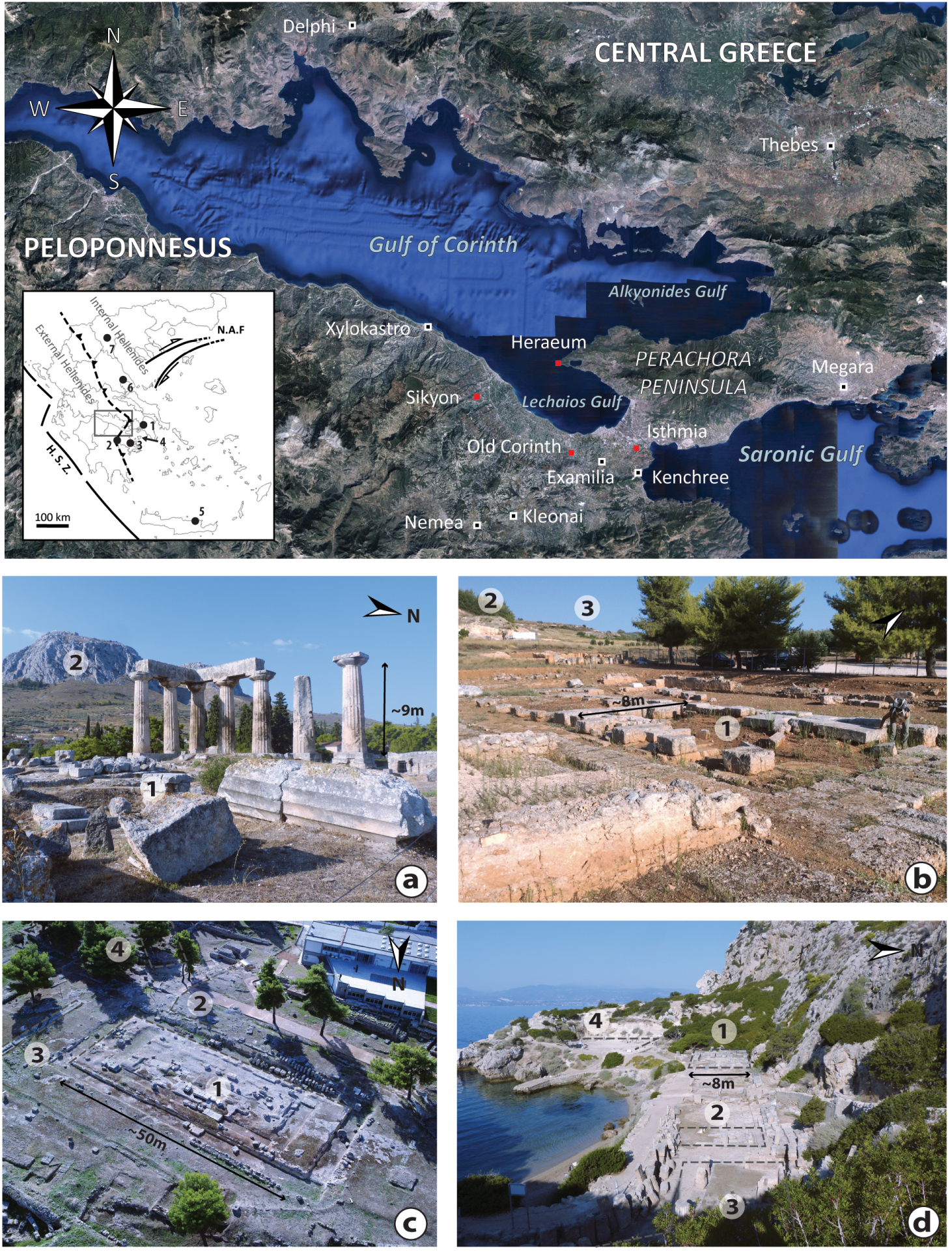
Geographical map of Gulf of Corinth with the main localities mentioned in the text, and the four studied sites in red. The small box shows the main tectonic features of the Hellenides chain: HSZ (Hellenic Subduction Zone), NAF (North Anatolian Fault); the Internal and External Hellenides are separated by a main thrust. The cities and their regions mentioned in the text: (1) Athens in Attica; (2) Argos and (3) Epidaurus in Argolis; (4) Aegina Island; (5) Malia in Crete; (6) Volos in Thessaly; (7) Asomata in Central Macedonia. Pictures of the archaeological sites in Corinthia: (a) The old city of Corinth, view of the Temple of Apollo (1) and the Acrocorinth (2). (b) Ancient Sikyon, view of the temple (1), the theatre (2) and the stadium (3) in the background. (c) Sanctuary of Poseidon at Isthmia, aerial view of the temple (1) with the temenos (2), the altar (3) and the old stadium (4). (d) Eastern part of the Heraeum at Perachora with the Temple of Hera Akraia (1), the altar (2), the stoa (3) and the West Court (4). All pictures belong to the authors except c, taken from the Corinth Museum Website (2021). Masquer
Geographical map of Gulf of Corinth with the main localities mentioned in the text, and the four studied sites in red. The small box shows the main tectonic features of the Hellenides chain: HSZ (Hellenic Subduction Zone), NAF (North Anatolian ... Lire la suite
The study focusses on Archaic to Hellenistic ashlar masonry—finely dressed cut stones, as opposed to rubble masonry, between the 7th and the 1st centuries BC. We exclude sculptures and other building materials such as wood or tile. Marbles are used for construction if available locally in large quantities, for example in the Cycladic islands or in Attica [Martin 1965], but they do not crop out in the Corinth area. Here, they will be referred to as allochthonous stones and their provenance will not be discussed, because it is a complex issue [Vettor et al. 2021]: macroscopic descriptions are not sufficient to differentiate white marbles and thorough analyses with destructive sampling techniques are required. We will focus on limestones, specifically on the facies called “pôros” in modern literature, a term that we will not use because of its lack of geological meaning. For dates, we have adopted the conventional nomenclature BC (Before Christ) and AD (Anno Domini).
In this paper, stone provenance will be addressed using three specific terms: local, regional and allochthonous. “Local” lithologies are those found within the archaeological site or in its close vicinity, usually less than 1 km away. Local stones would have been produced primarily by earthworks, employed directly for construction, and thus did not require transportation. Stones are termed “regional” when they have been sourced from a broader area, from a few kilometres to several dozens of kilometres, which suggests precise selection criteria (prestige, quality of stones and other criteria yet to be defined). Stones are termed “allochthonous” when they have been quarried from facies at considerable distance from the site: up to hundreds of kilometres and, in our case, outside the Gulf of Corinth. Our provenance label is thus linked to the city where the stone was used: the Corinthian oolitic grainstone is considered a regional stone in Sikyon, but a local stone in Corinth.
Finally, the history of each site goes back to Mycenaean times at least, as indicated by antique literary sources. This study focuses on the Archaic to Hellenistic period, when the city-state model was mature: our goal is to explore the link between geology and construction during this period, from a materials perspective. We summed up geological observations inside and outside the archaeological sites and examined the integration of the sites with local topography. This background work will allow us to identify possible recurrent patterns in building materials and bring a new perspective on ancient Greek construction.
1.2. Geological setting
The Gulf of Corinth is a late Miocene–Quaternary rift that separates the Peloponnesus from Central Greece and results from the migration of the eastern Mediterranean subduction zone and the propagation of the North Anatolian Fault (NAF) [Armijo et al. 1996; Le Pichon and Angelier 1979; Moretti et al. 2003; Papanikolaou and Royden 2007] (Figure 1). The rift trends roughly E–W with a N–S opening, and cuts the formal Hellenides thrust, which is separated into the Internal and External Hellenides and oriented ca. N160. The rift is bounded by numerous normal faults cutting through the mainly Mesozoic carbonate basement and the first syn-rift deposits.
The Peloponnesus, and so the southern rift margin, has been subject to uplift since 1 Ma, whereas the northern margin has been sinking [Bell et al. 2009; Collier et al. 1992; Moretti et al. 2003; Rohais and Moretti 2017]. The eastern part, in the Isthmus region, is cut by major normal faults: the South Alkyonides Fault System (SAFS), the Loutraki Fault (LF) to the north and the Kenchreai Fault (KF) to the south [Papanikolaou et al. 2015] (Figure 2).
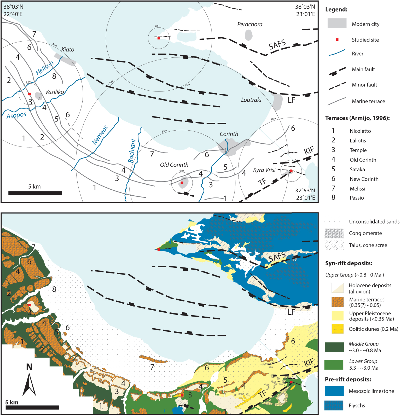
Topographic, structural and geological maps of the studied area, the south-eastern part of the Gulf of Corinth [compiled and modified from the IGME geological maps; Armijo et al. 1996; Collier et al. 1990; Collier and Thompson 1991; Keraudren and Sorel 1987; Papanikolaou et al. 2015; Rohais and Moretti 2017; Sébrier 1977; vonFreyberg 1973]. KIF: Kalamaki–Isthmia Fault; TF: Tamaris Fault; LF: Loutraki Fault; SAFS: South Alkyonides Fault System.
The global uplift of the Peloponnesus and the Isthmus has led to the exposure of complex syn-rift sedimentary units. These units record all water-level variations in the history of the Gulf of Corinth and are divided into three groups based on the syn-rift deposit classification [Rohais and Moretti 2017, and references within]: the Lower Group (5.3–3.0 Ma), Middle Group (3.0–0.8 Ma) and Upper Group (<0.8 Ma) (Figure 2). The Gulf was a set of lakes at the initiation of rifting, with mainly lacustrine and alluvial deposits at the base of the syn-rift series. The Middle Group deposits indicate a deepening of the depositional environment, with Gilbert-type fan deltas, distal turbidites and the deep marine facies further east. The Upper Group represents a major marine regression.
Two Upper Group formations are of particular interest here: a stepped marine terrace system in the region of Corinth up to Xylokastro, and beach-to-shoreface sequences cut by a horst-and-graben system in the Isthmus area [Armijo et al. 1996; Collier 1990, 1988; Collier and Thompson 1991; Papanikolaou et al. 2015; Sébrier 1977; vonFreyberg 1973]. The Perachora Peninsula also underwent regional uplift through the tectonic activity of the SAFS, leading to the formation of Pleistocene marine–shoreline deposits [Andrews et al. 2007; Dia et al. 1997; Leeder et al. 2008, 2005; Robertson et al. 2020] (Figure 2).
Each marine terrace is attributed to a Pleistocene sea-level highstand [Armijo et al. 1996; Imbrie et al. 1984]: six terraces in the Corinth area, splitting into eight terraces around Sikyon and ten further west, have been documented [Armijo et al. 1996; Dufaure and Zamanis 1979; Sébrier 1977]. The Laliotis (T2) and Sataka (T5) terraces are missing at Old Corinth, and younger terraces are more extensive north of Sikyon, near Xylokastro (up to ten). The Temple (T3) and Old Corinth (T4) terraces are the largest and most continuous: they can be followed from Corinth to Sikyon (Figure 2). This configuration gives the region the appearance of a large, flat amphitheatre, with a slight slope northward, incised by river valleys and opening up to the Gulf of Lechaios.
The terraces are composed primarily of conglomerates that unconformably overlie the “Corinthian Marls” [vonFreyberg 1973], which correspond to turbidites of the Lower and/or Middle Group, the latter of which is missing in the Isthmus area. However, the term “Corinthian marl” is often used without absolute dating in the literature and refers to unconsolidated units underlying the hard terraces. Over the Temple Terrace (T3) and the Isthmia sediment infill, oolitic tidal shoal formations, transverse dunes and longitudinal dunes are also present; the one near Examilia has been dated at 0.2 Ma and was quarried extensively in antiquity [Collier 1990; Collier et al. 1992] (Figure 2).
The terrace system does not extend to the Isthmus plateau, but the transition to other systems is unclear: the formations south of Loutraki could be linked to the New Corinth Terrace (6) [Collier and Dart 1991]. The Upper Group is composed of six transgressive–regressive cycles with erosive bases, defined onshore through the Corinth Canal and offshore thanks to recent core samplings [Collier 1990; Lykousis et al. 2007]. The Isthmia Graben is bounded by the Kalamaki–Isthmia Fault (KIF) to the north and by the Tamaris Fault (TF) to the south [Collier and Dart 1991; Papanikolaou et al. 2015].
The Holocene to Quaternary uplift of the Perachora Peninsula exposed marine–shoreline deposits. These are characterised by large microbial bioherms on the northwest shoreline of the peninsula’s tip [Kershaw and Guo 2006, 2003; Portman et al. 2005].
2. Materials and methods
2.1. Site selection
The site selection was based on historical, material and geological factors.
All four sites were active from the Archaic to Hellenistic periods. We excluded the pre-Archaic and Roman periods because of major differences in construction techniques and materials. It seems that wood prevailed before the 7th century BC, and the Romans used different building materials, mainly bricks and a large variety of stones from the Mediterranean Sea [Martin 1965; Orlandos 1968]. The Corinthian area had also undergone pronounced urban development by the end of the 7th century, with city wall construction in Corinth and temple construction in Corinth, Isthmia and perhaps Perachora [Wiseman 1978]. Thus, ashlar masonry is particularly relevant in the time span chosen. Furthermore, quarrying techniques did not change significantly over the time period considered here; the Corinthian region is well known for its building material industry, including stones, and many quarry centres have been identified [Fant 2009; Hayward 2003; Wiseman 1978].
Three of the sites include all the public buildings that are considered to characterise a city: a stoa (a portico), a theatre, a stadium, at least one temple and enough remains conserved for the study to be relevant. We focused on these monuments because houses and common buildings were built with wood and rubble. Previous authors have observed that stones were restricted to large public infrastructure and suggested that allochthonous facies, like marbles, were imported for temples only [Martin 1965; Wycherley 1976] (see Figure 1 for the different temples present on each site).
Finally, these sites are all located in a similar environment, on the recent geological formations of the Corinth Rift. This point is crucial for determining recurrent patterns. However, although the geology is comparable at a regional scale, the local environments exhibit fundamental differences, in terms of both the exact lithologies available and geomorphological conditions. Moreover, the sites are close enough to have allowed exchanges of technology and building knowledge; thus, we anticipate that the main material differences between the sites should be due to their geology, rather than their historical development.
2.2. Inside and outside the archaeological sites
The building material inventory within each site is limited to macroscopic observations: however, each site has been visited multiples times and the nature of the studied stones meant that macroscopic descriptions were sufficient to distinguish between different facies. For architectural parts and other inaccessible remains (e.g. those destroyed or stored in museums), we relied mostly on previous works (archaeological reports, monographs and previous articles). The material descriptions are based on the classic criteria of sedimentary rock classification: grain size and shape, matrix characteristics, fossil assemblages and sedimentary structures present. The distribution in percentage of facies employed is based on our personal observations of the actual remains conserved. These percentages are estimated very approximately and represent only the very first step of a quantitative study of building materials; accordingly, they are intended to be adjusted subsequently. Nevertheless, these calculations will allow us to determine the dominant or marginal facies used in construction based on numerical evidence.
Each archaeological site was studied separately for the sake of clarity. This choice originated from the quantitative approach applied in our survey (facies identification, percentage and number of facies). Site specificities are considered in the discussion to qualify our numerical results: that Corinth and Sikyon are city-states, whereas Isthmia and Perachora are sanctuaries under Corinthian influence.
The geological survey was conducted during field campaigns in 2019 and 2020. For each locality, the study focused on the lithologies available around the site, their accessibility and the characteristics of the local building stone resource. Cross-sections show the relationship between the remains and the environment, and sampling of natural outcrops allowed basic laboratory work to be undertaken. Thin sections were made at Sorbonne University, and density measurements were performed using the triple weighing method.
2.3. Limits of the study
The results are limited by the vestiges’ quality, access and conservation, as well as the complex history of each site. Most remains are Roman and post-Roman in Corinth and Isthmia: Corinth was sacked by the Romans in 146 BC, and the sanctuary of Poseidon was abandoned for two centuries with the transfer of the Isthmian Games to Sikyon. The Archaic Temple of Isthmia was burned down and replaced by the Classical temple (with a marble roof), which was damaged by fire again in 394 BC. Moreover, most building stones used for this Classical temple and the wider site were re-employed for the Hexamilion Wall, a Roman fortification built from the 5th century AD to close the Isthmus [Gebhard and Gregory 2015]. The city of Sikyon was destroyed in 303 BC by a Macedonian general and rebuilt uphill, on the current site [Lolos and Koskinas 2011]: only predominantly Hellenistic remains are now available. The Perachora sanctuary was presumably abandoned around the 4th century AD and no modern city developed above it [Lefèvre-Novaro 2000]).
All of the post-Greek modifications have introduced bias into the data corresponding to Greek times: missing facies, repurposed building stone (or spolia) for new constructions and mistakes in the identification of Greek remains. Thus, only the verified Archaic to Hellenistic remains were studied: that is, buildings that are unanimously considered to be from these periods by the academic community. Pre-Archaic monuments and clearly Roman monuments, as well as Roman renovation work, were excluded.
3. Results
3.1. The old city of Corinth
3.1.1. Topographic position and geomorphology
The site is located on Neogene to Quaternary sediments of the Peloponnesus, southwest of modern Corinth (Figure 2). The Mesozoic limestone basement composes the Acrocorinth, 1 km southward, but no older, magmatic or metamorphic units outcrop in the vicinity of the site. This means that there was no direct access to marble, granite or gneiss, but only to all of the lithologies of the syn-rift series: conglomerates, sandstones and marls from fine to very coarse, of fluvial to deep marine origin [Bornovas et al. 1972].
The site extends 2 km south of the current coast, and lies on two marine terraces initially defined by Sébrier [1977]: the Temple Terrace (T3) (ca. 240 ka) and the Old Corinth Terrace (T4) (ca. 210 ka) (Figures 2 and 3, map). The limit between the two terraces is poorly documented: the modern city extends all around the archaeological site, leaving few natural and accessible outcrops, and eluvial deposits cover the terraces. The main part of the archaeological site is located on the Temple Terrace (T3), but the gymnasium and the Asklepieion, with Lerna’s Spring, lie on the edge of the Old Corinth Terrace (T4) around 500 m northward (Figure 3, cross-section). The theatre, the first phase of which dates back to the 5th century BC, is built on the 30 m drop between the two terraces: the ancient Greeks took advantage of the difference in level to install bleacher seating. All these monuments, and most of the site, were used in the Roman period, when they were enlarged considerably [Sanders et al. 2018]. The Doric Temple of Apollo, ca. 23 m wide and 53 m long, seems deliberately built on the highest point of the archaeological site, and its foundations were carved directly out of the substratum (Figure 3a). It is one of the oldest monuments in the site, built in the 6th century BC, and the city developed around this natural hill as indicated by the implantation of Hellenistic and Roman monuments on its sides (Figure 3c) [Andrikou 2019].
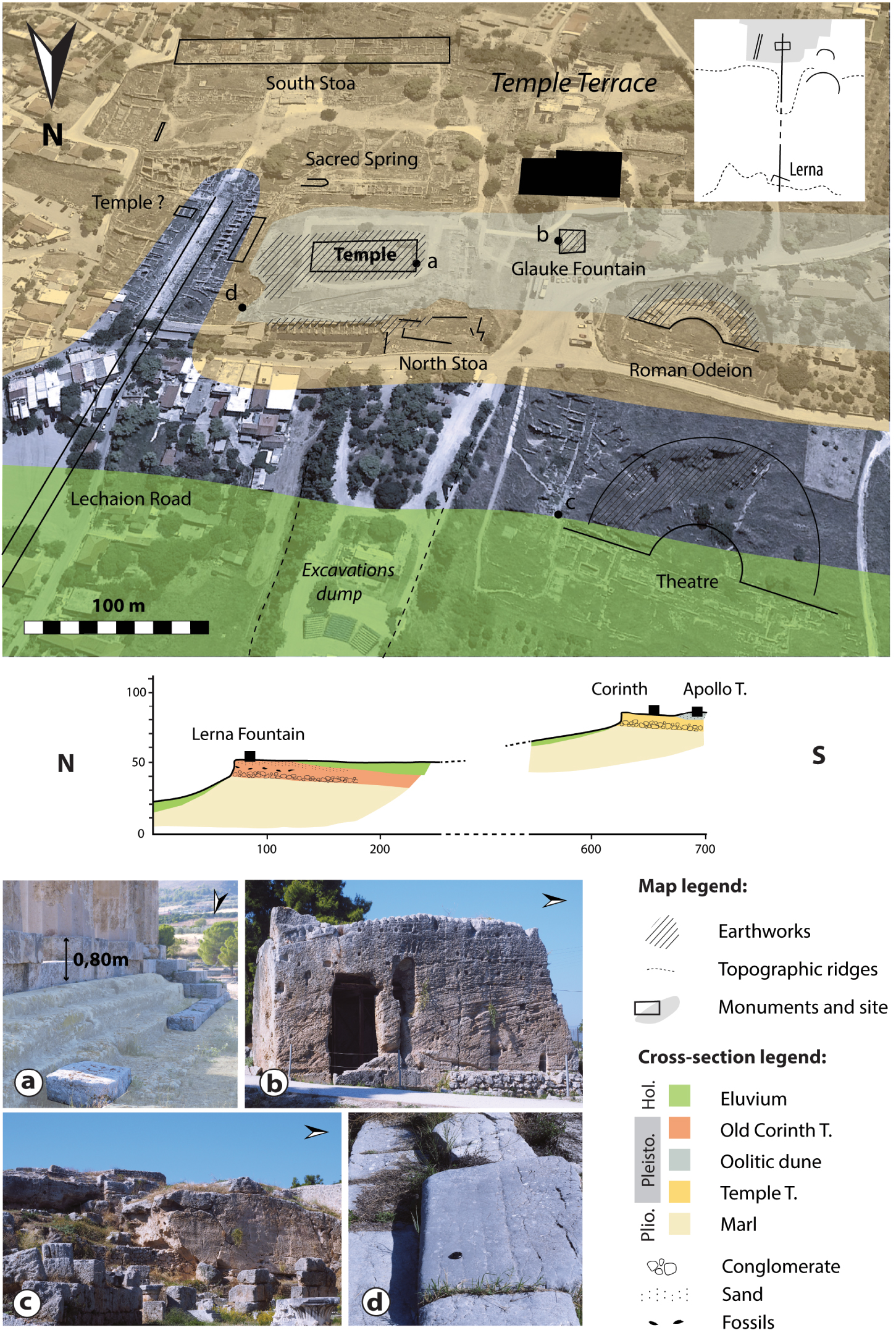
The old city of Corinth in its topographic and geological setting. Geoarchaeological map of the site with the main Greek buildings and geological units (base map from Google Earth (2020)). Simplified geological cross-section from the hill of Apollo to the Old Corinth Terrace at the Asklepieion [compiled and modified from Crouch 2004; Dufaure and Zamanis 1979; vonFreyberg 1973]. Pictures, (a) The frontal krepis of the Temple of Apollo, actual state, dug out of the oolitic dune (2020). (b) Glauke Fountains, also carved out of the oolitic dunes (2020). (c) Paved way to the theatre, in hard limestone (2019). (d) View from the Lechaion Road of the temple hill (2019). Positions of the cross-section and the pictures are shown on the geoarchaeological map. Masquer
The old city of Corinth in its topographic and geological setting. Geoarchaeological map of the site with the main Greek buildings and geological units (base map from Google Earth (2020)). Simplified geological cross-section from the hill of Apollo to the ... Lire la suite
3.1.2. Sedimentary description and materials available
The composition of the terraces differs more in terms of structure than lithology. The Temple Terrace (T3) corresponds to a single marine sequence: a 2-m-thick conglomeratic basal unit discordantly overlies the marls. Its thickness increases eastward, and a fine sandstone unit of beach sands overlies it. On top of the sandstone unit, two small transverse dunes, dated to 0.2 Ma and oriented E–W, form a 5-m-high and almost 1-km-long unit of oolitic sand with south-dipping sets and strong bioturbation (Figure 3, cross-section; Figure 3b, The Glauke Fountain is carved out of the dune). “Transverse” describes the dune morphology, in contrast to long linear dunes like that found at Examilia [Armijo et al. 1996; Collier and Thompson 1991; Sébrier 1977; vonFreyberg 1973]. Oolitic grainstone samples taken at Examilia show a density between 1.4 and 1.7 g/cm3 (number of samples measured: 11).
The youngest Old Corinth Terrace (T4) has a more complex structure, corresponding to two superimposed marine sequences with strong horizontal variability [Armijo et al. 1996]. The overall stratigraphy shows the following series over the marls: a discordant conglomeratic unit, a finer sand unit with marine bivalves or/and corals, a heterogeneous conglomeratic unit with centimetre-scale clasts (sometimes lacking, for example at the Asklepieion) and a thick beach-sand unit [Sébrier 1977; vonFreyberg 1973] (Figure 3, cross-section).
The conglomerates, dune facies and beach-sand unit are exploitable for ashlar masonry. However, the sandstone units are too thin (less than 1 m).
3.1.3. Building stones
The Greek city of Corinth seems to be built entirely with the grainstone of the oolitic dunes, taken directly from the substratum: a small Temple named A, the Hellenistic stoa, the South and North stoa, the theatre and the Temple of Apollo are the main Greek buildings within the site (Figure 3, map). Oolitic grainstone was also used extensively in the Roman period, hiding the Greek remains. It is the only facies employed for ashlar masonry, apart from the path to the theatre, which is paved with hard limestone of the Mesozoic basement. This is the only known and significant use of this limestone, although the reasons behind this choice have yet to be understood (Figure 3d).
Hard dark limestones have been employed for a few bases scattered across the archaeological site, and black limestone blocks considered to be from Argos are documented as spolia on the Lechaion Road [Williams et al. 1974]. Marbles were used mainly for sculpture and occur very late and in limited quantities in Old Corinth masonry: the Temple of Apollo marble pavement is a Roman renovation [Andrikou 2019; Johnson 1931; Maniatis et al. 2020].
The oolitic dune extending west of the archaeological site is identified as a quarry line 1250 m long, with extensive quarrying [Hayward 2003]. With a mean dune width and height of 25 and 5 m, respectively, this line corresponds to 150,000 m3 of material. The percentage loss during extraction and cutting is estimated to be around 25% depending on the nature of the stone [Amandry and Hansen 2010], and not all of the dune was exploited: ca. 50,000 to 70,000 m3 of material may have been quarried out. Earthworks are clearly visible inside the site: extraction traces and blocks in place are found east of the Temple of Apollo and the temple’s front krepis—the platform on which the building is erected—was carved out of the substratum. The krepis was covered with stone blocks, whereas the stylobate (the last bed of stones on which the columns were erected) and the columns are ashlar masonry (Figure 3a). The hard limestones could have originated from the Acrocorinth: the similarity in facies and its limited use within the site indicate a local provenance.
In summary, four lithologies have been documented at this site, but three of them (hard limestones, black limestones, white marbles) appear to represent less than 5% of the volume employed. The site is built of oolitic grainstone and on a quarry that seems sufficiently large to have supplied the material. The sandstones and conglomerates were not employed in construction, perhaps because the sandstone unit was too thin; even though the conglomerates are present in large amounts, the oolitic grainstone was definitively preferred by the builders.
3.2. Ancient Sikyon
3.2.1. Topographic position and geomorphology
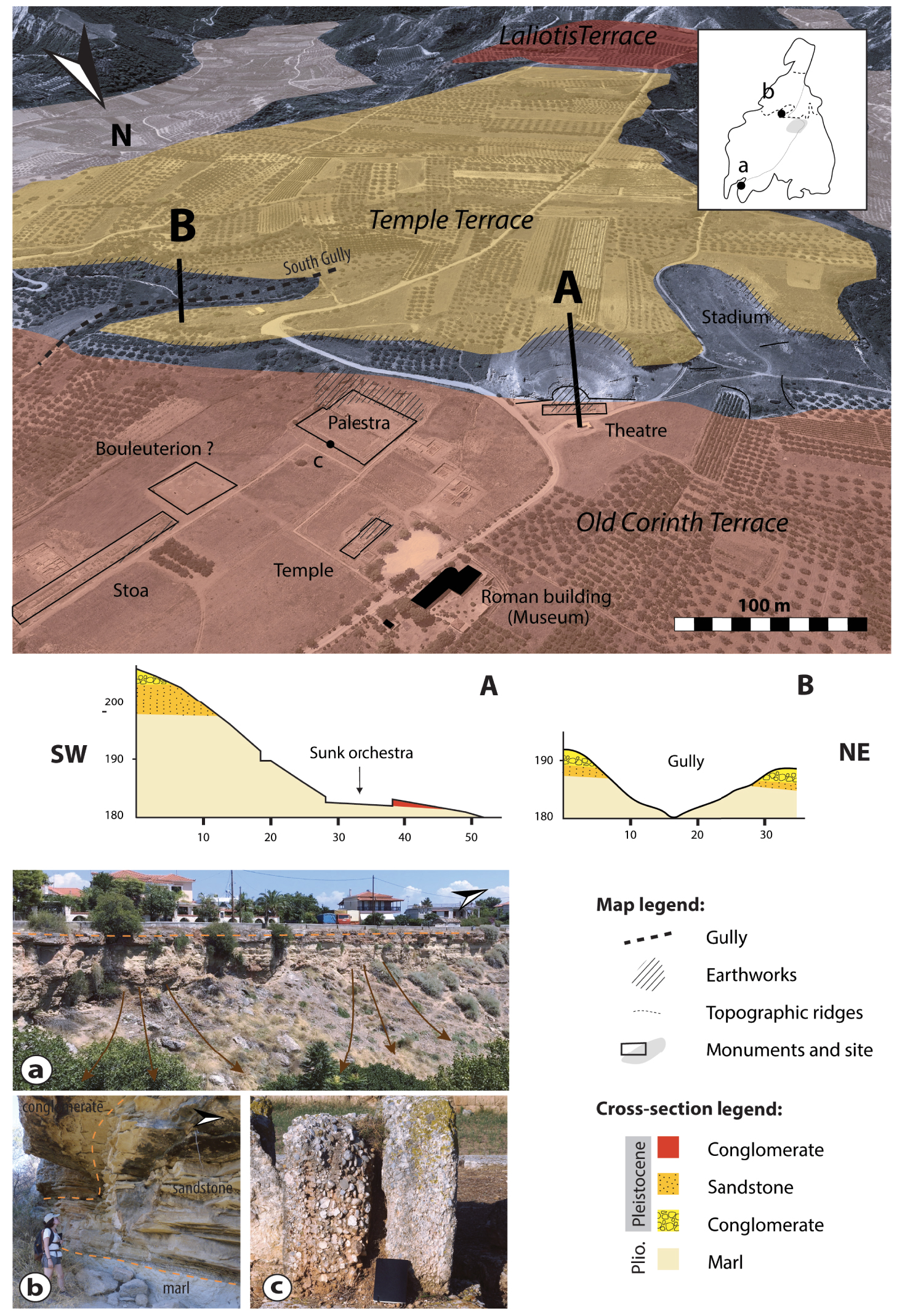
The site of Sikyon lays south of the modern village of Vasiliko, on the western part of the uplifted marine terraces (Figure 2). No volcanic or metamorphic units are present, and the pre-rift limestone basement does not outcrop in the vicinity of the site (the Acrocorinth is more than 20 km to the south). The Neogene to Quaternary recent deposits of the Middle and Upper groups [Rohais and Moretti 2017] are directly available and include the conglomerates and marls of the Middle Group, conglomerates of the Pleistocene terraces and recent alluvial deposits. Occasional units of sandstones and sedimentary travertine can be found outside the limits of the plateau [Koutsouveli et al. 1989; Tataris et al. 1970].
The plateau of Sikyon lies around 20 km west of Corinth and 5 km inland, surrounded by the Asopos and Helison valleys. It corresponds to three marine terraces, as defined by Sébrier [1977], from south to north broadly as follows: the Laliotis Terrace (2) (ca. 350 ka), the Temple Terrace (3) (ca. 240 ka) and the Old Corinth Terrace (4) (ca. 210 ka) (Figure 4, map). However, the vestiges are concentrated on the third terrace, even though the remains of the city wall can be found throughout the plateau. The theatre and the stadium take advantage of the large level difference between the Temple and Old Corinth terraces [Hayward and Lolos 2015] (Figure 4, cross-section).
The old city of Sikyon in its topographic and geological setting. Geoarchaeological map of the site with the main Greek buildings and geological units (base map from Google Earth (2020)). A and B: simplified geological cross-sections through the theatre and the south gully [cross-section A modified from Hayward and Lolos 2015]. Pictures, (a) The Old Corinth Terrace on the northern part of the plateau, under the modern city (2020). (b) Sandstone unit underlying the conglomerates and lying above the Corinthian marls, south gully (2020). (c) Architectural block of the archaeological site, in conglomerates (2019). Positions of the cross-sections and pictures are shown on the geoarchaeological map. Masquer
The old city of Sikyon in its topographic and geological setting. Geoarchaeological map of the site with the main Greek buildings and geological units (base map from Google Earth (2020)). A and B: simplified geological cross-sections through the theatre and ... Lire la suite
The vestiges correspond to the ancient acropolis, where the main buildings were excavated: a temple (perhaps dedicated to Apollo), ca. 11 m wide and 37 m long, built at the beginning of the Hellenistic period; a 106-m-long stoa or portico; a two-level palaestra, which occupied ca. 4500 m2; a 41 m2 bouleuterion (a council house); one of the largest theatres of the Hellenistic period; and the stadium of ca. 200 m long [Lolos 2016].
3.2.2. Sedimentary description and materials available
The data for Sikyon are summarised here. However, a more detailed study of the geological and geomorphological characteristics of the site and the identification of building materials in the archaeological site was undertaken by Ch. Hayward during the 2010s. The results should be published shortly as two chapters in the book of Lolos [2021].
The terraces are similar to those in Corinth and exhibit little variation (Figure 4a). The absence of oolitic dunes above the Temple Terrace (3) conglomerates is the main difference, with the presence instead of two sandstone units. A layered unit composed mostly of quartz lies at the base of the Temple Terrace (T3), under the conglomerates (Figure 4b). Thin pebbly calcarenite units overlie the conglomerate on both terraces. For heterogeneous facies such as these conglomerates, accurate density measurement can be difficult to achieve, because their density varies depending on the proportion of limestone clasts (2.7 g/cm3).
The main lithologies available on the Sikyonian plateau are marls, sandstones and conglomerates. The Corinthian marls are unconsolidated, and the sandstones are too thin to be exploitable for ashlar masonry. Therefore, only the conglomerates and calcarenites present here could be used for construction.
3.2.3. Building stones
All of the conglomerates present here were employed on the site: for the temple’s foundations, the stoa, the bouleuterion foundations, the palaestra and the stadium (Figure 4, map), as well as the defending and retaining city walls. These conglomerates are puddingstones, usually clast-supported, with clast sizes up to 10 cm in an argillaceous matrix; these stones are sourced directly from the terraces. They exhibit considerable variability in clast size, matrix proportion and degree of bioturbation. However, no clear link can yet be drawn between these variations and the use of this lithology in monuments (Figure 4c): these stones were employed for foundations, superstructures and columns, with clasts being cut and polished if needed. A local calcarenite was also used for the theatre and some architectural parts. Many quarry marks have been documented inside and around the archaeological site, on both marine terraces (Figure 4, map). According to the work of Ch. Hayward, the conglomerates were exploited most locally, while the calcarenite was almost entirely removed.
The only regional facies used for ashlar masonry is found in the temple and the bouleuterion: the temple pavement is constructed from oolitic grainstone (Figure 1b), and potentially its superstructure. Regional stones were probably used for statue bases exhibited at the museum entrance, made of hard limestones of unknown provenance, but probably from the Mesozoic limestone basement. Allochthonous white marbles are not observed in situ: only very few small statue pieces were found in previous excavations and some spolia in the theatre, for example [Fossum 1905].
In total, five different lithologies have been documented. Two of these are local and comprise more than 90% of the volume employed. The oolitic grainstone is a regional facies, even if its exact provenance cannot be determined. The same lithology outcrops between Sikyon and Corinth, 10 km eastward, and further away in the Corinthian region (the transversal and linear dunes defined above).
3.3. The sanctuary of Poseidon at Isthmia
3.3.1. Topographic position and geomorphology
The sanctuary of Poseidon is located in the modern village of Kyra Vrysi, 5 km inland from the Gulf of Corinth coastline and 1.5 km inland from the Saronic Gulf. It overlies consolidated Quaternary sediments of the Upper Group, representing an extension of the marine terraces of Corinth, which directly overlie the Lower Group because the Middle Group is missing here [Rohais and Moretti 2017] (Figure 2). No metamorphic or magmatic units are present, and the closest outcrop of Mesozoic limestone is 4.5 km southward. Thus, only the recent syn-rift formations are available: marls, conglomerates and sandstones, fine to coarse, marine to detrital [Bornovas et al. 1972; Gaitanakis et al. 1985].
Normal faults and the drainage network here created the main topographic features of the region. The archaeological site lies on the southern edge of the Isthmia Graben, surrounded by the KIF and the TF [Collier 1990] (Figure 2). The theatre was built on the step created by the offset of the Liopesi Fault, which dips northward. The settlement of Rachi is located on a hill that corresponds to the TF footwall. Three main gullies are present: one corresponds to the depression where the late stadium was built (Spardia Gully); one links the temple and the Roman baths (Temple Gully, subjective toponym); and the most important gully, Lepes Gully, bounds the site to the east.
As for Corinth, most buildings of the site indicate a complex history and a strong Roman influence. However, few remains are conserved: the Archaic temenos dates back to the 7th century BC, with the first Archaic temple, ca. 14 m wide and 40 m long, and a long altar. After the Archaic temple was destroyed by fire in 470 BC, the Classical Doric Temple of Poseidon was then built above it [Broneer 1971] and the long altar was enlarged, as was the peribolos. Isthmia was also one of the locations for the Panhellenic Games; different stadia succeeded each other, and the Games were removed by the Romans, until 44 BC where they came back at Isthmia. Finally, the theatre is mostly Roman, although a few remains indicate that its first use was during the Greek period [Gebhard 1973]. The site was abandoned and most of its materials were reused after the 4th century AD.
3.3.2. Sedimentary description and materials available
The site is located on the Upper Group formation of the syn-rift infill, composed of marine sequences, more precisely on a transgressive unit of beach-to-shoreface conglomerate and sand with an erosive base, unconformably overlying the marls of the Middle Group (Figure 5, cross-section) [Collier 1990; Rohais and Moretti 2017]. This unit exhibits large facies variability in both space and time. It corresponds to coarse-to-fine conglomerates, comprising 50–80% rounded centimetre- to millimetre-scale pebbles of primarily crystalline limestones and red radiolarites, with few quartzites. Accurate density measurements of such heterogeneous facies can be difficult to achieve, because their density depends on the proportion of limestone clasts (ca. 2.7 g/cm3).
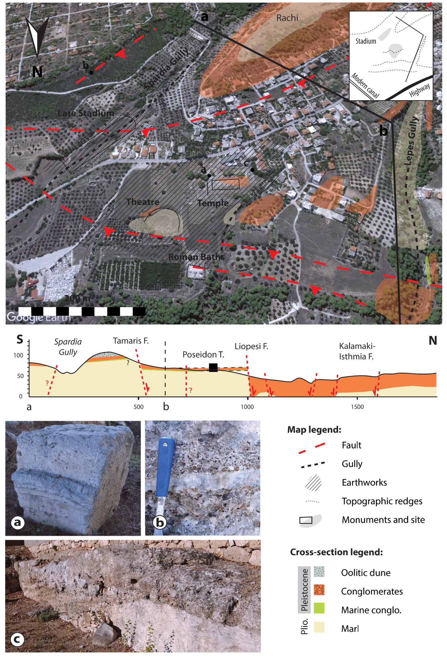
The sanctuary of Poseidon at Isthmia in its topographic and geological setting. Geoarchaeological map of the site with the main Greek buildings and geological units (base map from Google Earth (2020)). Simplified geological cross-section [compiled and modified from Collier et al. 1990; vonFreyberg 1973, and our own observations]. Pictures, (a) Architectural block of the archaeological site, in the oolitic facies (2019). (b) Conglomerate outcrop, south of Spardia Gully (2020). (c) Man-made cross-section inside the site, west of the temple, showing the organisation of the transgressive unit (2020). Positions of the cross-section and pictures are shown on the geoarchaeological map. Masquer
The sanctuary of Poseidon at Isthmia in its topographic and geological setting. Geoarchaeological map of the site with the main Greek buildings and geological units (base map from Google Earth (2020)). Simplified geological cross-section [compiled and modified from Collier et al. ... Lire la suite
Small marine units have been documented here: they crop out 300 m west of Kyra Vrysi, in the extension of the Liopesi Fault, and correspond to a marine detrital conglomerate with bivalves and perforated pebbles underlying the polymictic conglomerates. Within Lepes Gully, a fossil-rich marine laminated and heavily bioturbated sandstone underlies the 2-m-thick conglomerates. South of the late stadium, a finer layered polymictic conglomerate with a calcareous matrix of small oolites crops out (Figure 5b). On the Rachi Hill, a restricted unit of dune facies overlies a coarse conglomeratic unit. It is an oolitic grainstone with few fine conglomeratic units, and planar and cross-stratifications are visible. It extends towards the northwest and is not observed elsewhere around the site, but is similar to the grainstones observed at Corinth, Examilia and Kenchreai. No samples were obtained from the Rachi dune, but we consider its density to be similar to that of the oolitic dune of Examilia, i.e. around 1.6 g/cm3.
The conglomerates and oolitic grainstone from the Rachi Hill form thick homogeneous units that could be exploited for building materials. The other marine facies are too heterogeneous (in both nature and dimensions) and a small man-made cross-section, near the temple, illustrates the strong variability of this sequence (Figure 5c).
3.3.3. Building stones
The majority of the stones employed in the sanctuary of Poseidon consist of conglomerates and sandstones, including those used for the altar, the old and new peribolos, the stadium and the gateways. All of the facies observed in the field have been used in construction; however, there appears to be no logic determining the use of each sub-facies, with the exception of the shelly conglomerate and the impure oolitic grainstone. The shelly limestone was employed for foundations only (of two bases and the east gateway). This is attributable to the unit’s spatial heterogeneity, forming no large exploitable unit. However, most of the site superstructure is missing, so this hypothesis should be treated with caution. The finer impure oolitic grainstone was employed for architectural parts, like the dripstone exposed just outside the museum. The conglomerates come directly from the substratum: earthworks are clearly visible around the temples and up to the theatre. The Rachi settlement also shows quarry marks and was exploited for building material that could have also supplied the site of Isthmia.
A different homogeneous sandstone used for the Archaic temple, finer than that used for the Classical temple, was described by Broneer [Broneer 1959, 1955] [see Broneer 1959, plate 59, picture c]. However, the few remains conserved for both temples are inaccessible (access is forbidden, and blocks are difficult to identify), so we cannot be sure of the nature of the stone used for either of the temples (Figure 5a, and Figure 1 illustrate the poor state of conservation). The Classical Temple may have employed the impure oolitic grainstone. Regional and allochthonous stones remain marginal: a black limestone, perhaps from Argos, was used for statue bases; white marbles for the Classical Temple of Poseidon (roof tiles, sima), sculptures and statue bases; and grey-blue marbles from Laconia for sculptures [Broneer 1958; Gebhard et al. 1998; Gebhard and Hemans 1998; Sturgeon 2015].
In summary, seven different facies have been documented here, although their origins have yet to be fully assessed. All of the conglomeratic sequence sub-facies were used and constitute almost 90% of the volume employed (fine to coarse conglomerate, marine conglomerate). The oolitic dune facies could have come from the Rachi Hill or the region of Corinth: both cases would indicate a well-considered choice for an important building, the Temple of Poseidon. A low diversity of local stones was observed for monumental masonry, whereas specific stones may have been employed for sculptural works, statue bases or fine architectural parts.
3.4. The Heraeum at Perachora
3.4.1. Topographic position and geomorphology
The Heraeum is located at the tip of the Perachora Peninsula, on a natural bay looking southward to the Gulf of Lechaios. The coasts of Perachora and Corinth are approximately 10 km apart (Figure 2). The sanctuary sits on Quaternary deposits that cover the Mesozoic limestone basement. Sandstones, marls, stromatolites and limestones are directly accessible and flysch, schist and ophiolitic formations outcrop a short distance away within the peninsula, but no magmatic units or marbles are present [Bornovas 1984].
The SAFS, along with sea-level variations, influenced the morphology of the western tip of the peninsula (Figure 2). Many active E–W oriented normal faults cut the limestone basement and recent formations; freshwater leakages along these faults caused stromatolite growth. The flat surfaces here are wave-cut platforms resulting from the sea-level variations [Robertson et al. 2020].
The lower sanctuary is located on the hanging wall of a major normal fault dipping southward, with the Doric Temple of Hera Akraia, built in the 6th century BC, having dimensions of ca. 10 m (width) and 30 m (length); a 4th century BC altar and L-shaped stoa are located east of the temple. The upper part lies on colluvium filling a fault-induced slump, including the Temple of Hera Limenia, which may also date from the 6th century BC, and a 35-m-long double-apsidal cistern (Figure 6, map) [Payne 1940]. The city associated with the sanctuary lies on the upper plain, approximately 500 m eastward and 50 m uphill, where an elaborate hydraulic system with monumental cisterns was dug into the ground (colluvium and recent sediments) [Tomlinson 1969].
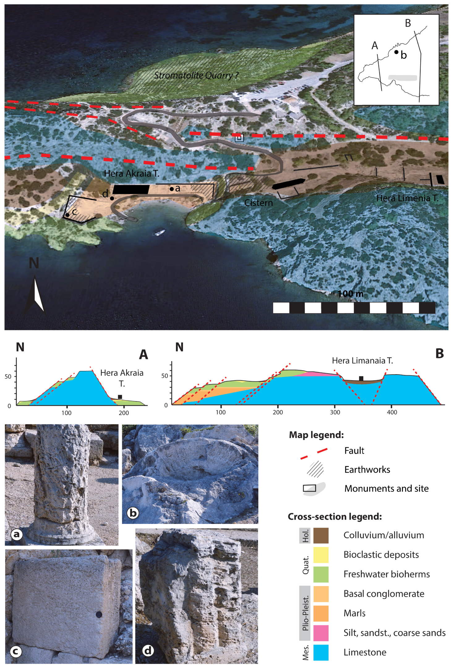
The Heraeum at Perachora in its topographic and geological setting. Geoarchaeological map of the site with the main Greek buildings and geological units (base map from Google Earth (2020)). A and B: Simplified geological cross-sections [compiled and modified from Andrews et al. 2007; Portman et al. 2005; Robertson et al. 2020, and our own observations]. Pictures, (a) Architectural block of the altar, in stromatolite rich-cavity build-up facies (2019). (b) (Man-made?) open stromatolite, north of the archaeological site (2020). (c) Clastic-bearing inner-dome stromatolite block in the West Court of the archaeological site (2020). (d) Architectural block of the Temple of Hera Akraia, in oolitic facies (2019). Positions of cross-sections and pictures are shown on the geoarchaeological map. Masquer
The Heraeum at Perachora in its topographic and geological setting. Geoarchaeological map of the site with the main Greek buildings and geological units (base map from Google Earth (2020)). A and B: Simplified geological cross-sections [compiled and modified from Andrews ... Lire la suite
3.4.2. Sedimentary description and materials available
A succession of Neogene to Quaternary formations lies unconformably on the limestone basement, a blue karstic Mesozoic mudstone to wackestone. A Pliocene–Pleistocene unit, composed of marls, sands and conglomerates, is overlain by algal mound bioherms, also called stromatolites [Portman et al. 2005; Robertson et al. 2020]. Recent marine formations overlie the stromatolites, with colluvium deposited on the topographic troughs (Figure 6, cross-section).
The stromatolites grew along the faults with freshwater leakage on both coasts of the peninsula, but they are particularly well preserved to the north. They form large platforms with a dome morphology. Samples from the stromatolite quarry (?) (Figure 6, map) exhibit a density of 1.5 g/cm3 (number of samples measured: 7).
A large variety of facies is accessible: bioclastic fossil-rich limestones, sandstones, yellow marls and all of the sub-facies of the stromatolite dome (Figure 6b). The stromatolites and the limestone basement form large and homogeneous units exploitable for building material.
3.4.3. Building materials
Local stones represent the most employed facies: stromatolites, grey hard limestones and bioclastic limestones. The entire stromatolite dome sequence was used for ashlar masonry: the stromatolite rich-cavity build-up, the laminated stromatolite, the clastic-bearing and massive inner dome (Figure 6a and c). The bioclastic limestones come from the marine terraces above or below the stromatolite formations: the localised use of small amounts of these limestones in the altar pavement indicates a local origin. The hard limestones are not employed in the sanctuary or for hydraulic infrastructure, but used only as rubble in the city buildings, e.g. for house foundations.
Regional and allochthonous stones are marginal here: the oolitic grainstone from Corinth, and white marbles with other unknown origins, were employed for the Temple of Hera Akraia [Menadier 1995].
In summary, five different facies have been documented here. More than 90% of the site has been built with the stromatolite sub-facies: it is an accessible and profitable resource (short distance from the quarry and large quantities available). We observed quarry marks on the north coast of the peninsula (Figure 6, map), and the fractured stromatolites could indicate human action. Quarry marks are also documented in the upper plain, north of the city [Tomlinson 1969]. The local hard limestones are not employed in the sanctuary but as rubble within the city, unlike the allochthonous materials that are used only in the sanctuary, for the Temple of Hera Akraia.
4. Discussion
4.1. Predominance of local high-porosity/low-density calcareous stones
Ancient Greek builders prized local sedimentary stones for their public infrastructure: conglomerates in Sikyon and Isthmia, oolitic grainstone in Corinth, stromatolite in Perachora. These stones comprise more than 80% of the volume employed at each site. The economic criterion seems to dominate the choice of building material: local stones require no transport, and blocks produced by earthworks can be used directly in construction. The few archaeological sources available regarding stone costs, particularly the construction accounts for Delphi, Delos and Epidaurus, suggest that the stone itself had no real price [Mathé 2010], and that the transport, cutting and laying of blocks dominated the overall cost of imported stones. We hypothesise that, by using local stones, stone costs would have been reduced significantly.
Additionally, geotechnical characteristics may have had some influence. The lithologies studied are usually called “pôros” in both modern and ancient literature: this refers to recent consolidated sediments with medium to low density, usually of light colour and easy to work with. Generally, it does not include conglomerates, although the finer conglomerate facies (in terms of granulometry) are sometimes referred to as pôros. High-porosity calcareous facies seem to have been sought after, like the calcarenite of Sikyon and the finer conglomerates of Isthmia; this is clearly illustrated by the oolitic grainstone facies that was exploited and exported widely. It can be observed in other regions: in Thessaly, at Volos, travertine from 6 km away [Vaxevanopoulos et al. 2015] and oolitic limestones from 70 km away [Melfos et al. 2016] were imported for construction.
Although used extensively, conglomerates do not meet all of the criteria for a good building stone [Bessac and Sablayrolles 2002]: they are heterogeneous and not particularly light, difficult and hazardous to cut and extract, inadequate for the finest architectural parts and subject to weathering. This is another argument for a primarily economic reason behind the choice of building material, as conglomerates were only used in the Corinth area when outcropping. A local breccia with similar properties was also employed in Delphi [de Vals et al. 2020]. However, conglomerates were not employed when an alternative existed, like the oolitic grainstone at Corinth.
In Sikyon and Isthmia, hard limestones are not directly available, but they outcrop at Perachora and in the vicinity of Corinth. However, they were not employed at all for ashlar masonry in any of the studied sites: this suggests that stone hardness was not a highly ranked criterion. The weight criterion seems more conclusive in the choice of building material: hard limestones were employed only when directly available and if no other less dense stones were present, in Delphi [de Vals et al. 2020] or in Epidaurus [Varti-Matarangas and Matarangas 2000].
A poor diversity of facies was observed for local and regional stones: in general, a single local lithology was used for most of the site, and a maximum of five different facies in total have been identified at any one site. This is illustrated in Figure 7, with the number of facies for each site shown on the left. On the right, the graphic illustrates the distribution of stones by origin, in terms of volume (%), for each site. Each site was considered globally. Allochthonous facies can be varied, but they represent less than 5% of the stone volume employed and were not used for the large ashlar blocks. With the exception of Delphi, regional and allochthonous facies represent less than 15% of the total stone volume [de Vals et al. 2020].
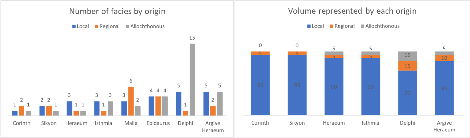
Left, the number of facies by origin (local, regional, allochthonous) at the four studied sites and four other sites: Epidaurus [Varti-Matarangas and Matarangas 2000], Delphi [de Vals et al. 2020], the Argive Heraeum [Pfaff 2003] and Malia [Dimou et al. 2000]. Right, the volume of each facies by origin. Marbles were excluded for the comparison by number of facies; they are negligible in terms of volume.
For all of the studied periods, a high diversity of stones (more than ten) was observed in renowned sanctuaries in particular: in Epidaurus, Delphi and the Heraeum of Argos, for example. However, the last two sites exhibit a high diversity of white allochthonous marbles: four different types were identified [Maniatis et al. 1988; Pfaff 2003]. Such detailed investigations were not undertaken for all of the archaeological sites: white marbles were generally counted as a single facies, which biases the comparison. Moreover, ten different porous allochthonous limestones have been observed in Delphi: as of now, this is considered an exception. Delphi, Epidaurus and the Argive Heraeum also exhibit medium diversity for hard limestones (more than three facies), which are absent at the four sites studied here.
These data should be qualified based on site history and geology. The archaeological sites discussed above are located within different geological settings: on the syn-rift infill of the Gulf of Corinth (present study), or directly on or next to the Mesozoic limestone basement (Delphi, Epidaurus, Argive Heraeum, Malia). Furthermore, Epidaurus, Delphi and the Argive Heraeum are located more than 10 km inland, and less expensive sea transport was prized. Epidaurus and Delphi were renowned within the Panhellenic world in Classical times, whereas Malia was a Minoan palace. This means that the builders did not have access to the same stones or the same economic resources. They also did not have the same aim: in the Panhellenic sanctuaries, the Ancient Greeks wanted to show their gratitude by building wealthy treasuries and monuments. In contrast, constructions in city-states are more practical (fortification walls, stoa, agora). These data put our study into perspective, but the comparison should be treated with caution.
4.2. Specific stones for specific uses
One regional facies recurs in all of the sites: the oolitic grainstone, a dune facies of Corinthian provenance. We do not know the exact origin: three main outcrops have been identified, in Corinth (tidal transverse dunes), near Examilia (tidal longitudinal dunes) and near Kenchreai (transverse dunes) [Collier and Thompson 1991] (Figure 2). The determination of distinctive criteria between these different dunes would require more in-depth work and sampling of the sites. At Isthmia, we hypothesise that the facies used for the Archaic Temple of Poseidon is a dune facies. We base this assumption on a recurrent pattern observed in the region: the temples of Sikyon, Perachora and Kleonai (personal observations) used the same facies of Corinthian origin.
The imported stones, regional or allochthonous limestones, were usually employed only in the temples. The Corinthian dune facies was also used for many treasures (small temples or buildings to display offerings) and for the Temple of Apollo from the 4th century BC at Delphi [de Vals et al. 2020]. Our observations confirm the conclusions of previous works [Martin 1965; Wycherley 1976], which noted that allochthonous stones were employed for large-scale public infrastructure. However, previous studies referred mostly to marbles and did not separate clearly the different “pôros”. Our conclusion is that the use of allochthonous stones concerns more specifically temples, and is applicable also to less prestigious stones (not only marbles); this includes high-porosity limestones with fine granulometry such as the oolitic dune facies in the eastern part of the Gulf of Corinth.
Local facies dominate ashlar masonry, but different materials were observed, sometimes specifically between foundations and superstructures; this includes the temples at Sikyon and Perachora (Figure 1), but also other monuments and bases, for example, the bouleuterion of Sikyon. This is common in Greek construction, even if not recurrent in our study. This pattern has been observed at other sites: the Temple of Apollo from the 4th century BC at Delphi and the second Classical temple of the Argive Heraeum both have soft limestone foundations with a hard limestone pavement [de Vals et al. 2020; Pfaff 2003].
Finally, imported stones are typically used for temples, but this was not observed in Corinth, which employed a local limestone for its Temple of Apollo. This raises the question of the dominant criterion determining the choice of building materials, if there is just one: is it a purely economic decision, or do prestige and mechanical characteristics come into play? A similar situation has been observed in Athens: the Parthenon is made entirely of marble, mostly because it was the nearest viable resource. However, we cannot answer this question for now: the Archaic Temple of Corinth, which does not include marble, is also one of the oldest temples built during the 6th century BC in the Doric style, just at the beginning of the extensive marble trade [Martin 1965].
4.3. Exploitation of the environment
Earthworks are visible inside each site and have furnished building materials, produced by small limestone quarries. In Corinth, it is plausible that the oolitic dune facies inside the city was sufficient to provide the city, at least in Greek times, but this hypothesis has yet to be verified because other large quarries near Corinth exploited similar dune facies. The small quarries near Sikyon, Isthmia and Perachora provided materials only for their respective cities: owing to their size and stone character, these quarries were not suitable for exportation. This is coherent with what is known of Greek stone exploitation: quarries were often small, episodic and tied to specific construction projects [Fant 2009].
Many small porous limestone quarries have been documented in Greece [Koukouvou 2012]. However, the lack of in-depth and consistent studies of these quarry types has prevented the determination of large-scale trends; accordingly, the prevailing knowledge of limestone exchange is certainly biased, unlike our knowledge of the marble trade [Al-Bashaireh 2021]. For example, large sedimentary stone quarries that exported their materials are known in the Greek world: the quarries of Aegina Island [Koukouvou 2012] and the quarries of the Corinth area (Examilia, Kenchreai) [Hayward 2003]. Oolitic limestone quarries are documented in Thessaly, at Tyrnavos, which furnished with building materials Larissa (17 km away), Volos (70 km away) and ancient Demetrias (next to Volos) [Melfos et al. 2016]. The Kleonai quarries [Marchand 2002], the quarries of the Asomata region in Central Macedonia [Koukouvou 2010] and the Piraeus quarries [Theoulakis and Bardanis 2000] are very large high-porosity-limestone quarries but seem to have provided building material for one unique site each (Nemea, Aigai and Athens, respectively).
Freshwater resources abound in the studied region, with monumental fountains and developed hydraulic systems at all sites, as predicted by Crouch [2004]. The builders of the sites also took advantage of the main topographic features: in Corinth, Isthmia and Sikyon, the theatres rest on the steepest slope close to the site. Faults or natural terraces caused these anomalies and revealed the unconsolidated marls underlying the hardpans. Then, the Greek builders used the marls depending on their cohesiveness: ashlar blocks were added for the seat when too soft (Corinth, Isthmia); otherwise, the seating was carved out directly (top of the theatre at Sikyon).
5. Conclusions
We presented in this paper a large-scale study of four Archaic to Hellenistic Greek sites within their geological environment, the eastern part of the Gulf of Corinth. The comparison of building materials for ashlar masonry allowed us to define some trends.
- Ancient builders took advantage of the main topographic features of the sites, with the construction of theatres occurring on natural slopes, cliffs, faults or terrace offsets.
- Primarily, local lithologies were employed. They represent more than 90% of the stone volume and were sourced mostly from earthworks.
- Usually, one local facies was found to be predominant, which suggests that choices were made based primarily on the economic criterion.
- As a result, with access to porous sedimentary building material, the sites studied here exhibit low facies diversity (<5).
- Recent low-density sedimentary stones of the syn-rift deposits were preferred even when other facies were available: at Perachora, the Mesozoic basement (2.7 g/cm3) and the stromatolites (1.5 g/cm3); at Corinth, the conglomerates (between ∼2 and 2.7 g/cm3) and the oolitic grainstone (1.4 to 1.7 g/cm3).
- Greek builders rarely imported hard limestones (Argos stones, Mesozoic basement) but could import the finest high-porosity facies for temples, as illustrated by the Corinthian oolitic grainstone.
Our conclusions should be tested with a larger group of sites, particularly sites lying directly on the limestone basement with no direct access to recent porous limestones. This could contribute to a better comparison and understanding of limestone use and trade in Greek construction. We have shown that allochthonous limestone facies, other than marbles, should not be overlooked: they are also exported for specific use in religious monuments. It will also be important to look more closely at the geotechnical characteristics of stones, for which we have only scratched the surface here: density seems a decisive factor, but stone behaviour regarding water (permeability, porosity, capillarity) should not be overlooked.
Conflicts of interest
Authors have no conflict of interest to declare.
Acknowledgements
This work was supported financially and materially by the French School at Athens, who granted the doctoral contract of Ms. de Vals, and Sorbonne University in Paris. Fieldwork authorisation in the Corinth area was given by the Hellenic Survey of Geology and Mineral Exploration (HSGME). Density measurements were carried out at the Cergy-Pontoise University Laboratory. We thank Y. Lolos for giving us access to the pre-publication of his synthesis on Sikyon and A. Perrier for many discussions about Delphi. We also thank Isotope Editing for editing a draft of this manuscript.