

1 Introduction
Paleo-valleys represent a key feature for sequence stratigraphy. Many studies focus on them because their sediment infill constitutes a more complete record of the sea level cycles than adjacent interfluves. Paleo-valley systems are known from the Palaeozoic to the Holocene (i.e. the Aquitaine shelf with the Quaternary valley of the paleo-Gironde [20]). Incised valleys are typically interpreted as evidence of sea level falls, but can also be linked with uplift, climate or sedimentation rate changes [30]. They are a link between the continental fluvial systems and the deeper water (slope, canyons and abyssal plain). Their occurrence is not random and they often follow structural weakness areas of the substratum (e.g. faults, depression zones linked to diapirs or folding) [3,8,26].
Two major canyons settled down on the Aquitaine shelf: the canyon of Cap Ferret and the canyon of Cap Breton. Surprisingly, the canyon of Cap Ferret did not seem to have a paleo-valley network on the sea surface off the adjacent continental shelf, whereas the canyon of Cap Breton, located southwards, has one [8]. In fact, the cruises ITSAS (sedimentary processes and deposition off the Bay of Biscay margin) highlight a paleo-valley network buried under less than 30 m of sediments and associated with the canyon of Cap Ferret. One particularly interesting fact is that these paleo-valleys are located close to a hinge zone called the Celt-Aquitaine flexure separating two very different shelves constituting the Aquitaine shelf (Fig. 1): a relatively stable northern shelf (Armoricain shelf) and a subsiding and diapiric southern shelf (Basin of Parentis).
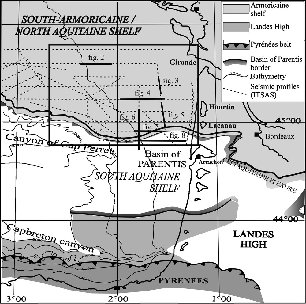
Different domains of the Aquitaine shelf (modified after Bois and Gariel [4]) and ITSAS seismic profiles in the study area.
Fig. 1. Les différents domaines de la plate-forme Aquitaine (modifiés d’après Bois et Gariel [4]) et les profils sismiques ITSAS localisés dans la zone d’étude.
The aim of this article is to understand why, when and how these paleo-valleys occurred in this area. High-resolution seismic data allows us to describe at least four generations of paleo-valleys which stacked through time. From the valley pattern, we will deduce an evolution of the hydrographic paleo-drainage located on the North-Aquitaine shelf.
2 Regional setting
The North-Aquitaine shelf corresponds to the southern part of the Armoricain shelf. The substratum of the Armoricain shelf dips gently towards the southwest [5,22]. It is composed of tilting blocks formed during the Cretaceous rifting overlapping by Cenozoic sedimentary deposits that form discordant sedimentary units of Palaeogene, Miocene and Plio-Quaternary in age. These units thicken from the Estuary of Gironde to the Basin of Parentis (South Aquitaine shelf) and to the canyon of Cap Ferret where they have a sedimentation rate two or three times higher [11,29,31].
In detail, on the North Aquitaine shelf, Frappa [11] indicated that the extended Eocene ended up with a strong erosional surface maybe linked to the erosive cycle associated with the Oligocene regression. The Late Oligocene deposits correspond to a thicker unit deposited in unconformity on the substratum filling, the depressions remaining at the end of the Eocene. The sedimentary facies are lightly deformed and show a complicated organisation and ended up with a regressive facies. The Miocene sediments also deposited with an unconformity with a more important south-westwards dip. The unconformities inside the sedimentary unit are numerous and are the result of erosion-deposition processes and channel incisions which took place mainly between the latitudes of the Lake of Lacanau and the Basin of Arcachon. The Miocene deposits outcrop on the outer shelf in front of the Gironde Estuary. They ended up with a Late Miocene surface which levels out the underlying deposits. The Plio-Quaternary deposits cover the whole outer shelf between the slope break and 130 m depth where they pinch out.
The sedimentary basin of the Aquitaine is filled by sediments derived from the Aquitaine rivers. These rivers have changed their direction from east-west to a northwest orientation trough time. By the Late Pleistocene, they had reached the location of the Gironde Estuary [16,18].
3 Materials and methods
Seismic data have been acquired during the ITSAS cruises (August 1998 and June 2001) on the R/V “Le Suroit” on the Aquitaine shelf. The positioning was done using differential GPS. The seismic source was a single channel sparker SIG regulated on a 650 J power and an 800 Hz centre frequency. The shooting interval was one second. The seismic source allows a vertical resolution about 1 millisecond two way time (ms twt) and a penetration around 400 ms twt. Another seismic source of lower frequencies was used (single channel). It permitted deeper penetration but at lower resolution. The recording data and real time processing were carried out by the DELPH 2 software. The seismic profiles were reprocessed with the SITHERE software (IFREMER) using bandpass filter, swell filter, mute, multiple and gain [19].
Seismic lines have been interpreted using the seismic stratigraphic concepts of Mitchum et al. [21] applied to high resolution seismic. Interpretation of the very high-resolution seismic data allows the identification of six seismic units interpreted as depositional sequences according to the definition of Chiocci [7] and Lericolais et al. [20].
4 Results
The seismic facies of the North Aquitaine shelf show several seismic units bounded by discontinuity surfaces (Figs. 2–4). In order to understand the processes which govern the paleo-valley formation, the underlying and the overlying units surrounding them will be briefly described. Then we will focus on the paleo-valleys units which are the subject of this paper.
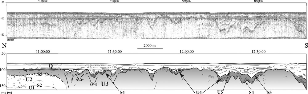
Located in the north (see Fig. 1), this east-west sparker profile shows the west slope of the seismic units from U1 at the base to Q at the top which covers all the underlying units. U2 shows three seismic facies (a, b, c and d) and is not folded. U3-1 shows sigmoid reflections and disappears on the east part of the profile. The seismic facies of U3-2 is completely different with chaotic and high amplitude facies and channels.
Fig. 2. Localisé au nord, ce profil sparker est-ouest montre le pendage ouest des unités sismiques de U1 à la base à Q (dernière unité déposée qui recouvre l’ensemble des unités sous-jacentes) au sommet, séparées par des discontinuités allant de S2 à Sq. U2 montre trois faciès sismiques (a, b, c et d) et n’est pas déformée. U3-1 se caractérise par des réflecteurs sigmoïdes et disparaît à l’Est du profil. Le faciès sismique d’U3-2 est totalement différent avec des réflecteurs chaotiques de forte amplitude et des chenaux.
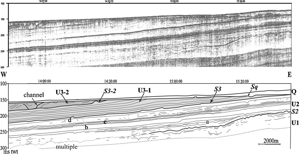
North-south sparker profile (location see Fig. 1) located in front of the Lake of Hourtin, showing the South slope of the units. U2 is composed by three facies (b, c and d) and begins to be deformed and faulted. U3 is not present on the first north part of the profile. The last unit Q bounded at the base by Sq covers the whole area.
Fig. 3. Ce profil sparker nord-sud localisé en face du lac d’Hourtin (voir Fig. 1) montre le pendage sud des unités sismiques. U2 commence à être déformée et faillée. U3 se biseaute rapidement vers le nord. La dernière unité Q, limitée à la base par Sq, recouvre l’ensemble de la zone.
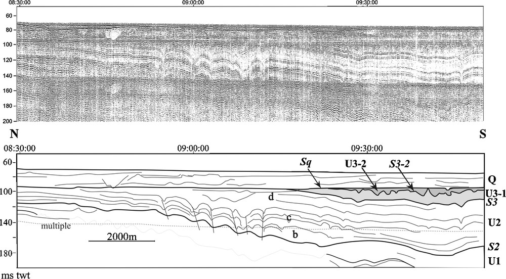
East-west profile located in front of the Lake of Hourtin (location see Fig. 1) showing the stacking of the four sets of channels. The unit U2 is faulted and folded. U3-1 is almost completely eroded except in the east part of the profile. From U3-2 to U4 (details [a] to [d]), the seismic units move westwards. They are mostly bounded by channels corresponding to the surface S3-2, S3-3, S3-4 and S4.
Fig. 4. Profil sparker est-ouest localisé en face du lac d’Hourtin (position voir Fig. 1) montrant la succession des quatre séries de chenaux. L’unité U2 est faillée et déformée. U3-1 est presque entièrement érodée et n’est présente que dans la moitié est du profil. D’U3-2 à U4 (détails [a] à [d]), les unités sismiques se déplacent vers l’Ouest du profil. Ces unités sont limitées à la base par les chenaux cités ci-dessus formant les surfaces S3-2, S3-3, S3-4 et S4.
4.1 The Aquitaine shelf units
The lower seismic units (U1 and U2) show internal reflections with a regular slope towards the west or the southwest. U1 upper boundary corresponds to a high amplitude surface (S2), indented in some place. U2 is characterized by high amplitude parallel reflections with good continuity and shows a specific facies (U2c) presenting high amplitude and good continuity reflections easily recognizable. From north to south, U2 evolves from sub-horizontal and bedded strata (Fig. 2) to more and more deformed beds showing folds and/or faults (Figs. 3–5). Its upper boundary S3 is a high amplitude and good continuity surface. U3 will be studied in detail in the next paragraph. It could be separated in four seismic sub-units due to the erosional channel-shaped surfaces. The different sub-units were grouped in a single unit because of the difficulties for following the facies towards the south and the west. U3 ends up by a very erosional surface (S4) which is continuous and of high amplitude in the outer shelf. U4 (Figs. 4–7) corresponds to the infilling of the channels. Its boundary corresponds to a strong amplitude and good continuity surface. U5 is the upper part of the infilling of the channels. It is strongly eroded on the median shelf and presents a medium amplitude basal surface S5. Sq is the last discontinuity. It levels all the underlying deposits which present erosional toplaps. Q is the last deposit unit and covers most of the continental shelf.
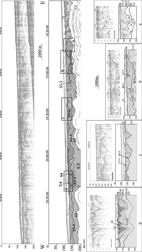
South prolongation of the sparker profile of the Fig. 3. Due to the acoustic mask of the surface S4, only two sets of channels are present (U3-4 and U4). The U4 infilling becomes more complex southward. The last filling unit U5 appears.
Fig. 5. Prolongement vers le sud du profil sparker de la Fig. 3. À cause du masque acoustique provoqué par la surface S4, seulement deux séries de chenaux sont visibles (U3-4 et U4). Le remplissage d’U4 devient plus complexe vers le sud. La dernière unité de remplissage des chenaux U5 apparaît.
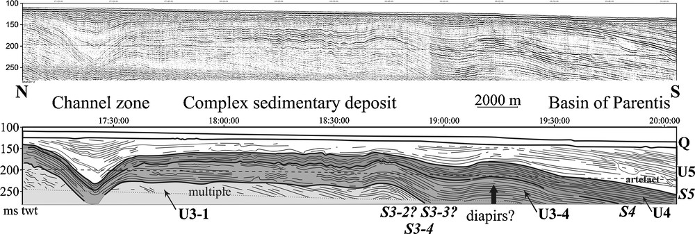
North-south single channel profile (location see Fig. 1) showing oblique reflections may represent U3-1 eroded by the upper unit (U3-4). The unit U3-2 and U3-3 are not present. The surface splitting U3-1 to U3-4 could only represent S3-4 or a stacking of more erosional surfaces (S3-2, S3-3 and S3-4). The channels inside the units U3-4 and U4 are stacked and disappeared southwards where reflections deformed by a diapir are present.
Fig. 6. Profil sismique nord-sud (position voir Fig. 1) montrant des réflexions obliques représentant probablement U3-1 érodée par U3-4. La surface séparant U3-1 d’U3-4 peut uniquement correspondre à la dernière surface S3-4, mais peut aussi représenter un empilement des surfaces érosives S3-2, S3-3 et S3-4. Les chenaux présents à l’intérieur des unités U3-4 et U4 s’empilent et ne sont plus présents vers le sud, où des déformations vraisemblablement dues à un diapir sont visibles.
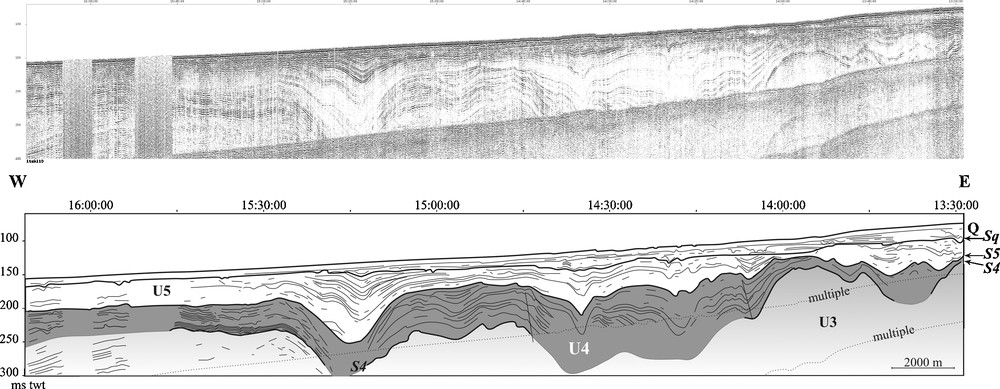
East-west sparker profile located in the southern part (location see Fig. 1). U3 is acoustically masked by the surface S4. U4 channels are larger and deeper than northward and look like paleo-canyons with stratified infill ending up by the unit U5.
Fig. 7. Profil sparker est-ouest localisé dans la partie méridionale de la plate-forme Nord-Aquitaine (position voir Fig. 1). U3 est acoustiquement masquée par la surface S4. Les chenaux formant U4 sont plus larges et plus profonds qu’au nord et ressemblent à de petits paléo-canyons, avec un remplissage stratifié se terminant par U5.
4.2 Paleo-valleys units: U3 and U4
Unit U3 is subdivided in four subunits (U3-1, U3-2, U3-3 and U3-4). At the base of the unit U3, S3 shows a high amplitude and a good continuity. On this surface, sigmoid-oblique reflections characterize a lower subunit U3-1 mainly preserved on the North of the study area (Fig. 2). The reflections become oblique with a more important slope southwards where they disappear under the multiple except in the southernmost area (Figs. 6 and 8). On Fig. 4, the reflections of U3-1 are conformable with those of U2. U3-1 is quickly eroded offshore by S3-2 and by Sq towards the coast. S3-2 is covered by a chaotic facies U3-2 eroded by a succession of paleo-channels from U3-2 to U3-4. The chaotic facies at the base of U3-2 is covered by high amplitude and discontinuous reflections with small channels in the north (Fig. 2). The channels become more and more developed southwards. The channels that occur in the three upper units of U3 (U3-2, U3-3 and U3-4) present the following characteristics (Fig. 5):
- • the first channels, included in U3-2, are only preserved in the East and the North of the study area. Their reflections are of variable amplitude and continuity. The channels are small (about 15–20 ms twt depth) and narrow (about 200 m). They can erode the underlying sediment until U2 with a high density of channels in some places. In fact, their location seems to be controlled by the presence of syncline shapes in the substratum formed by the folded unit U2. Their fill is often transparent and shows more rarely chaotic facies. In the south (Fig. 6), it is difficult to differentiate S3-2 to S3-3. Nevertheless, this high amplitude surface erodes oblique reflections;
- • a second subunit U3-3, located further towards the west and the south, overlies U3-2 with a higher amplitude and more continuous basal erosional surface S3-3. Channels included in U3-3 are larger (about 2500 m wide) with a 20-30 ms twt depth and show a lower density than in U3-2. The fill is transparent to bedded at the bottom and becomes more chaotic upwards. In the west, beyond to the channels, the facies is more homogeneous and bedded;
- • the third subunit U3-4 is bounded by a distinct basal erosional surface which has a better continuity and a high amplitude S3-4. Southwards, the formation of the surface S3-4 led to an erosion down to the oblique reflections of U3-1 (Fig. 6). The channels are less numerous than in U3-2 or U3-3. Their width and depth are more variable and generally increase to the south. Their infilling begins with a bedded facies which becomes more chaotic upwards.
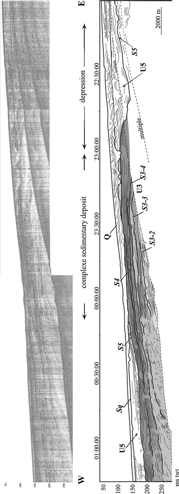
Sparker profile in the South of the study area (location see Fig. 1). There are no more channels except a depression in U5 eastwards, against the complex sedimentary deposit composed by aggrading and prograding reflections.
Fig. 8. Profil sparker situé au Sud de la plate-forme Nord-Aquitaine (positions voir Fig. 1). Il n’y a plus de chenaux à l’intérieur de U3 et U4 qui forment un corps sédimentaire montrant une structure polyphasée, avec des réflexions progradantes et agradantes. Une large dépression remplie par U5 s’appuyant sur ce corps sédimentaire est présente à l’est.
In the southernmost part of the North-Aquitaine shelf, notably in the south of Lacanau, significant differences appear in the channel pattern (Fig. 8). Channels similar to those described above have disappeared and give place to a large depression close to the actual coast (about 8 km width and more than 180 ms twt depth) with an east-west orientation. This depression is bounded westwards by a complex sedimentary deposit (CSD), constituted by several packages of oblique reflections of variable slope (aggrading and prograding reflections) bounded by discontinuity surfaces. These discontinuity surfaces may be correlated with the secondary surfaces S3-2, S3-3 and S3-4. Oblique reflections may be bounded by S3-2, so this westwards prograding facies similar to the one on the Fig. 6 could correspond to U3-1. Upwards, S3-2 is covered by less tilting reflections limited by S3-3. Another oblique facies is bounded by S3-4 which is covered by a retrograding facies.
U3 crops out around 110-120 m depth. It constitutes an irregular rock ground named “croches”.
Upper boundary of U3, S4, has a very high amplitude and good continuity. Its strong amplitude blocks the penetration of the acoustic waves and then masks the lower units which are not visible in the South of the study area on the sparker profiles. S4 limits the last channel network U4. These channels have the same location than U3-4's where it is visible on the seismic profiles (Figs. 4 and 5). The channel fill (U4) is only observed in the region Lacanau-Hourtin. The channels are narrow (less than 400 m width), deep (more than 30 ms twt) and have the same density than the U3-3 channels. They are not cut by any younger erosion surfaces (Figs. 4 and 5). Northwards, their upstream infilling is transparent on to chaotic. Southwards, the bottom of the channels deepens and the downstream infilling thickness increases. The channels become larger and the bedded reflections constituting the channel fill are more continuous and goes on with the unit U5 (Figs. 6 and 7). In the southernmost part of the study area, south to the deepest channels, the channels suddenly disappeared and the U4 facies evolves in retrograding or prograding reflections on the top of the CSD (Fig. 8).
4.3 Isochron and isopach maps
Due to the difficulty following the sub-units U3 under the unit U4, we only present the isochrons of S4 and the isopachs of U4. The erosional surface S4 marks the last channels (Fig. 9). The isochron lines draw a great number of NE-SW oriented channels. They can cut down up to 100 ms twt. Westwards, they join a depression (A; Fig. 9) related to the canyon of Cap Ferret. In the centre, they flow into an east-west oriented gully (B; Fig. 9), which is bounded southwards by a threshold (C; Fig. 9) corresponding to the CSD. The CSD does not show any channel but a stacking of prograding and retrograding reflections. It seems to lean against a relief probably in relation with a diapir (D; Fig. 9), frequent on the South Aquitaine shelf [4]. A single “channel” (depression, E; Fig. 9) is located eastwards to this body. It is interpreted as a rim syncline related to a diapiric uplift [3,26].
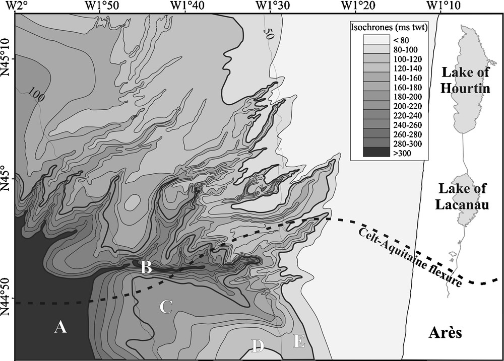
Isochron map of the surface S3 in twt ms. A. Basin in relation with the canyon of Cap Ferret. B. East-west channel, C. Complex sedimentary body. D. Diapir? E. Onshore depression.
Fig. 9. Carte des isochrones de la surface S3 en ms twt. A. Bassin en relation avec le canyon du Cap Ferret. B. Chenal est-ouest. C. Corps sédimentaire montrant une structure polyphasée. D. Diapir ? E. Dépression située à l’est.
The isopach map indicates an infilling direction towards the southwest (Fig. 10). To the west, an accumulation zone (A) is in direct relation with the canyon of Cap Ferret trough a threshold (B). In the centre, an internal sub-basin (F) is isolated to the zone (A) by a shallower area with a thinner sedimentary cover (C) and (D), and a particular accumulation zone (E) constituted by the onshore depression which led against the CSD mainly composed by older units (U2 and U3) and a thinner unit U4.
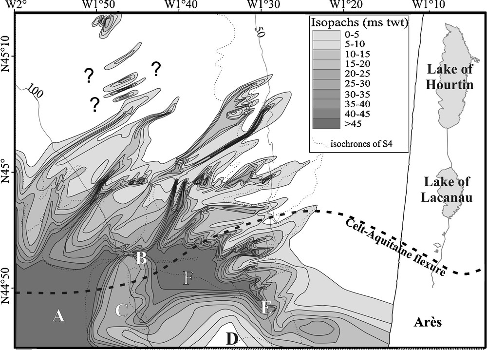
Isopach map of the unit U4 in twt ms. A. Basin in relation with the canyon of the Cap Ferret. B. East-west channel. C. Complex sedimentary deposit. D. Diapir? E. Onshore depression. F. Internal little basin.
Fig. 10. Carte des isopaques de l’unité U4 en ms twt. A. Bassin en relation avec le canyon du Cap Ferret. B. Chenal est-ouest. C. Corps sédimentaire montrant une structure polyphasée. D. Diapir ? E. Dépression située à l’est. F. Bassin interne.
Channel direction and the renewed incision of the old channels suggest a preferred orientation (fault network or tectonic elements) and a single supply direction.
5 Discussion
5.1 Stratigraphy
Due to the lack of long cores and drilling on the North-Aquitaine shelf, the stratigraphic interpretation is poorly constrained. Nevertheless, the comparison with previous works presented below allows us to present rough ages for the different seismic units.
On the Armoricain shelf, three deposition sequences dated from Palaeogene, Neogene and Plio-Quaternary were described [11,23,29]. The Miocene unit interpreted by Frappa [11] is the one which contains channels similar to those found in U3 and U4. We can also compare U5 and Q with the Plio-Quaternary unit. S5 should correspond to the Messinian regression. The U3 Miocene age is confirmed by “Helvetian” marine crop out (by comparison with log in the continent [15,17] at the top of the unit).
On the South-Aquitaine shelf, petroleum wells were described [1,2]. They do not allow a detailed stratigraphy but they separate the Miocene from the Plio-Quaternary. Thanks to seismic profiles crossing the Aquitaine shelf from the canyon of Cap Breton to the Celt-Aquitaine flexure, we can use the descriptions of petroleum wells located on the South-Aquitaine shelf. By comparison with these data, the dating of U3 and U4 to the Miocene and U5 and Q to the Plio-Quaternary is confirmed.
The sedimentary sequence boundaries frequently correspond to erosional surfaces often created by sea level falls with usually channels and interfluves, the highstand surfaces often being eroded by the next sea level fall. Sequence stratigraphic Table (Fig. 11) proposes a hypothesis on the correlation between the seismic unit boundaries and the stratigraphical sequence boundaries [12–14,27,28].
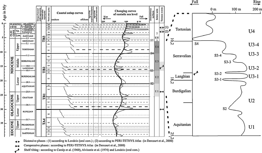
A. Sequential stratigraphic Table correlating the seismic unit boundaries of the North-Aquitaine shelf with the stratigraphical sequence boundaries [12–14,27,28]. B. Detail of the sea level changes and more precise correlation with the units U3 and U4.
Fig. 11. A. Tableau de la stratigraphie séquentielle corrélant les limites des unités sismiques de la plate-forme Nord-Aquitaine avec les limites stratigraphiques de séquences [12–14,27,28]. B. Détails des variations du niveau marin et correspondance avec les sous-unités d’U3 et U4.
Ages of U3 and U4 should be between the earlier Miocene and the Messinian regression (S5). To constrain the beginning of their formation, we have considered the underlying deposit U2. U2 is interesting because it is not deformed, like U3-1, in the northern area in opposite to the southern region where it shows faults and folds: it marks a deformation period of the substratum. This tectonic phase could correspond to the tectonic phase recognized during the Middle Miocene in deep water [10]. It acts on the crystalline basement which has a brittle behaviour [11]. In contrast, the sedimentary cover shows a more flexible behaviour and is folded. It likely occurred during or after the deposition of U3-1 as its reflections are parallel and deformed as those of U2 on the Fig. 4. Moreover, U3-1 pinches out eastwards before the coast and it is probably not present on the continent in the northern area like the Langhian deposits (Figs. 2 and 3). In the same time or lightly after this deformation phase, the Middle Miocene (Langhian-Serravalian) is characterized on the continent by structural tilting which leads to an uplift of the northern Aquitaine shelf ([2,6,12], and recent works of Londeix: oral communication). The uplift is about 30 m, occurred at the end of the Langhian [12] and northwards to the flexure of the Douze, located lightly southwards to the Celt-Aquitaine flexure and with the same orientation. In fact, the Langhian which is the more transgressive period of the Neogene is absent on the whole north margin of the Aquitaine Basin [9]. In this case, the ages of the units U3 and U4 should be constrained between the Langhian and the Messinian.
U3 is subdivided in four subunits (U3-1, U3-2, U3-3 and U3-4) bounded by three secondary surfaces (S3-2, S3-3 and S3-4) and the upper boundary surface S4. These four surfaces are well-correlated with four third order cycles in the Middle Miocene (Langhian-Serravalian) of Haq et al. [13] (cycles 2.3, 2.4, 2.5, 2.6; in details Fig. 11). In this hypothesis, U4 belongs to Tortonian. Its lower boundary shows a strong erosive facies which can correspond to the important regressive phase around 10.5 My.
In details, U3-2 channels may have been put in place during the Upper Langhian sea level fall. This fall could have been accentuated by the north uplift. After an important transgression in the Lower Serravalian, U3-3 channels were formed following by those of U3-4 and U4 during the Serravalian sea level falls.
5.2 History of the channels
The unit U3 is significant in the Aquitaine shelf evolution because it marks a great change in the sedimentary processes, with the occurrence of numerous channels. Although the unit U2 does not contain channels, it is also important for the understanding of the channel settling. In fact, its northern part is not folded and not covered by the same kind of channels found southwards where it is folded and faulted. U2 deposited during a high sea level was later deformed, as well as U3-1, by a tectonic phase during the Middle Miocene [10]. The sigmoid reflections of U3-1 could indicate a regular deposit under a relatively stable sea level, probably after the first minor sea level fall during the Langhian which brought the source of sediments closer to the continental shelf, increasing the sediment rate from U2 to U3-1. Southwards, the evolution in oblique facies could mark a more important increase in the sedimentary input maybe linked to the vicinity of the subsiding zone of Cap Ferret which traps the sediments. A major erosional phase ended up U3-1 as it was almost completely eroded in front of Hourtin. Like shown above (heading 5.1), this phase could correspond to the sea level fall between the Langhian and the Serravalian combined with the tectonic phase which uplifted the North-Aquitaine shelf [12]. In fact, the deformation phase ended up before the formation of U3-2 as it does not seem deformed itself.
The important facies change of U3-2 highlights modifications in deposit processes and sedimentary input nature. In fact, instead of parallel beds of U2, the facies becomes chaotic and eroded by isolated channels in the northernmost area. Southwards, the number of channels increases and the erosion of the chaotic facies becomes stronger. The general formation of channels could have several causes: change of sea level base, variations in climate or sedimentation rate [25]. In our case, both a minor sea level fall and the North-Aquitaine uplift led to a formation of a great marshy or deltaic plain on the continental shelf with the creation of distributary channels which stacked in this area. The channels are progressively filled with homogeneous sediment until a new channel is created by avulsion. The next marine transgression deposited fine bedded sediments. They are eroded by the second channel formation U3-3 deposited on S3-3.
The U3-3 channels are larger, less mobile and their boundary S3-3 is of higher amplitude and continuity than the channel surfaces of U3-2. They used the pathways created by U3-2 channels. Nevertheless, their different facies indicate a longer erosion as the channels are wider [25]. This could correspond to the beginning of the sea level fall during the Serravalian. The bedded or transparent facies in the channel bottom indicates some sorting and homogeneity of the sediments or an energy decrease of the deposit environment maybe in relation with a minor sea level rise. It also seems to correspond to the homogeneous facies, less tilting, deposited on the surface S3-3 around the Celt-Aquitaine flexure. The more heterogeneous sediment fill at the top and a new cutting of the lower channels may have been provoked by an increase of the sediment rate.
The third set of channel bottom is bounded by S3-4. The channels, located more southwards, are spread on the whole Lacanau-Hourtin region. Their strongly erosive facies indicates probably an eustatic origin. These channels moved on progressively westwards, giving evidence of a coast moving in the same direction. This could indicate that the sea level drops may have become deeper and deeper from S3-3 to S3-4. In the south, close to the Celt-Aquitaine flexure, S3-4 truncates the oblique reflections. The sea level fall may have led to an erosion of a great part of the shelf. A new transgression led to a sediment fill of the channels and the formation of the retrograding reflections formation on the CSD.
S4 gives evidence of another sea level fall and the renewed development of the former fluviatile drainage, close to the Medoc coast, which may have transported a constant sedimentary load and whose the equivalent is not found in the vicinity of the Gironde estuary. The channels gather together and head for the Cap Ferret canyon. They evolve from a coarse fill in the northeast and the east (upstream infilling), formed in one or two phases, to a multiphase fill towards the southwest (downstream infilling): the northeast and east channels are closer to the supply inputs and are quicker filled by coarse sediments (chaotic facies, few continue reflections) while the southern channels are deeper and at the end of the drainage. They are filled with finer sediments probably deposited during several deposition periods as the infilling also includes the unit U5 and several of them seem to have been definitively filled during the formation of the last unit Q, that is the opposite of the north channels which are eroded before or during the formation of the surface Sq.
During the sea level fall, the sedimentation rate increases due to the accommodation space increase and the supply input was going to provoke sediment accumulations and to constitute the CSD close to the east-west gully ([A] on the Fig. 9). The CSD shows internal structures like tidal sand bodies (estuarine banks or fluviatile-estuarine environment).
This CSD constitutes a threshold which plays an important role because it splits the North-Aquitaine shelf to the Basin of Parentis. It prevents the channels going to the Basin of Parentis, what is the opposite of the regional slope and it imposes them a westwards direction change towards the canyon of Cap Ferret. Moreover, in the South of this deposit, the substratum does not seem to be folded.
Threshold presence can be explained by an uplift of the southern region. The CSD is located lightly in the south of the Celt-Aquitaine flexure. This region is marked by several Jurassic and Upper Cretaceous normal and strike-slip faults which delimit blocks, each one being able to have different behaviours. Moreover, the Basin of Parentis shows diapirism. Diapirs are also present on the boundary of this Basin (Fig. 9) and could explain the presence of this threshold.
5.3 Drainage pattern evolution
On the North-Aquitaine shelf, the described channels can be joined to the coastal plain valleys [24,32]. Moreover, their repetitive incisions give evidence to one or more rivers present in this area which run on a great time scale (several million years) (Fig. 12). The more eastern incision (stacked channels, U3-2) could correspond to the channel and estuarine barrier facies located at the boundary between the middle and distal segment. Then the other valleys better marked and more regular, may correspond to the more external valleys, that is the distal incised valleys. At last, the more external incisions have an infilling which can characterize sub-marine valley or small canyon in permanent marine and deep environment.
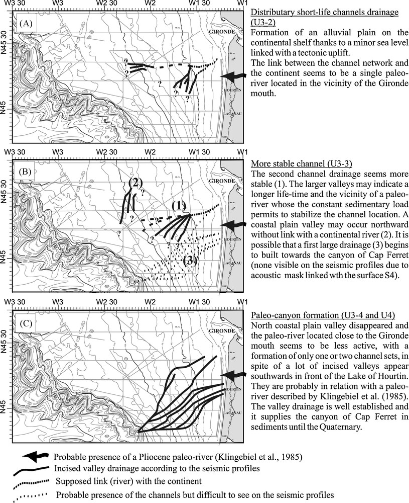
Schematic picture of the river drainage evolution during U3 and U4 according to the seismic profiles.
Fig. 12. Évolution du réseau de palaéodrainage durant la formation d’U3 et U4.
The location of the different channels is given on the Fig. 12. The south orientation of the channels is probably due to the north tilting. The distributary channels can be attributed to one or more rivers (Fig. 12A). The absence of channels along the actual coast may indicate either the paleo-coast was further westwards than today and then the shallow river bed on the continent has been eroded, the paleo-river (paleo-Dordogne?) which formed this valleys was located around the actual Gironde, maybe in taken the same way or some of these distributary channels correspond to the coastal plain incised-valley system without connection to the continent [32]. The stable channels are more towards the west and the southwest (Fig. 12B and C). Klingebiel and Legigan [16] indicate a paleo-river presence around Hourtin which could be the link between the channels found on the continental shelf and the coastal plain. This river may have supplied stable sedimentary inputs allowing incision durability in the Northeast of the Cap Ferret canyon.
6 Conclusions
The canyon of Cap Ferret is linked to the continent by four sets of buried channels formed during the Miocene from the Langhian to the beginning of the Tortonian. The formation of the channels has been favoured by both a north shelf tilting at the end of the Burdigalian, responsible of faults and folds, and sea level falls, especially during the Serravalian. First, distributary channel stacked mainly in the depressions made by the folds on a great marshy or coastal plain off the continental shelf. They mark a great change in the sedimentation linked both to the uplift of the North-Aquitaine shelf and a minor sea level fall occurring in the beginning of the Serravalian. This first formation of channels likely favoured the other channel formations during the following sea level fall of the Serravalian as they have been found at the same location.
The second set of channel shows longer life-time and more stable channels. The third and fourth sets of channels show similar characteristics (low mobility, strong lower boundary, upstream coarse sediment infilling evolving in a downstream fine-grained sediment infilling) and evolve in paleo-canyons at proximity of the canyon of Cap Ferret where they flow into. The last set of channels formed during the last major Serravalian sea level fall.
The presence on a great time-scale of these channels indicates the erosional action of one or more rivers on the Aquitaine coast during the Miocene. Their locations are probably controlled by the substratum as they are bounded northwards by the tilting of the shelf and southwards by the complex sedimentary deposit and diapirs. This location is not insignificant because this complex deposit is situated close to the Celt-Aquitaine flexure and constitutes a boundary between the passive North-Aquitaine shelf and the subsiding Basin of Parentis. Its presence prevented the formation of paleo-valleys towards the Basin of Parentis what it should have been the normal channel orientation.