

Version abrégée
1 Introduction
La Ligurie centrale (Apennin septentrional, Italie) représente une zone, géologiquement compliquée (Ligurian Knot de Laubscher et al. [15]), comprise entre la ligne Sestri–Voltaggio et la ligne Villalvernia–Varzi (Fig. 1), constituée par deux linéaments structuraux principaux, qui tiennent un rôle important dans la définition des rapports entre les Alpes et les Apennins [9,23].
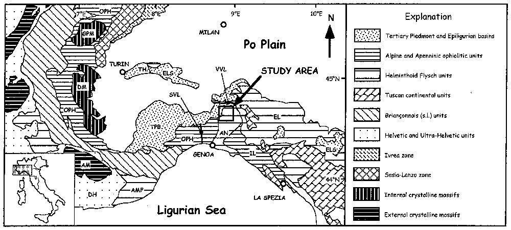
Tectonic sketch map of the Northern Apennines and Ligurian Alps; the study area represented in Fig. 2 is indicated. TPB: Tertiary Piedmont Basin; TH: Torino Hill; ELS: Epiligurian Succession; OPH: Western Alps ophiolitic units; IL: Internal Liguride units; AMF: Maritime Alps Flysch; AN: Antola unit; EL: External Liguride units; GPM: Gran Paradiso massif; DM: Dora Maira massif; AM: Argentera–Mercantour massif; SVL: Sestri–Voltaggio line; VVL: Villalvernia–Varzi line.
Schéma tectonique de l'Apennin septentrional et des Alpes ligures, avec localisation de la zone examinée. TPB : Bassin tertiaire piémontais ; TH : collines de Turin ; ELS : succession épiligure ; OPH : unités ophiolitiques des Alpes occidentales ; IL : unités ligures internes ; AMF : flysch des Alpes maritimes ; AN : unité Antola ; EL : unités ligures externes ; GPM : massif du Grand-Paradis ; DM : massif de Dora Maira ; AM : massif de l'Argentera–Mercantour ; SVL : ligne Sestri–Voltaggio ; VVL : ligne Villalvernia–Varzi.
La déformation de cette zone s'est développée à partir du Crétacé supérieur jusqu'au Néogène, durant la convergence et la collision continentale qui l'a suivie entre les plaques Europe et Adria.
En Ligurie centrale, les unités océaniques, appelées unités ligures, déjà déformées avant l'Oligocène, sont recouvertes, en discordance, par une épaisse succession sédimentaire qui s'est déposée au sein d'un bassin épi-sutural appelé Bassin tertiaire piémontais (TPB), à partir de l'Éocène supérieur jusqu'au Miocène tardif. La succession du TPB est généralement interprétée comme appartenant à un monoclinal non déformé plongeant vers la plaine du Pô.
Les résultats de la campagne structurale effectuée en moyenne vallée de la Borbera (Ligurie centrale) illustrent une histoire tectonique polyphasée, développée aux niveaux structuraux les plus superficiels, intéressant non seulement les unités ligures, mais aussi la succession du TPB.
2 Cadre géologique
Les unités ligures, situées au sommet de la pile d'unités tectoniques de l'Apennin septentrional, sont composées de fragments du Bassin océanique liguro-piémontais et de la zone de transition à la marge continentale Adria. À l'Oligocène–Miocène, ces unités ont été charriées sur les domaines plus externes, correspondant à la marge continentale Adria (domaine Toscan–Ombrien). Les unités ligures sont caractérisées par des séquences ophiolitiques jurassiques et leurs couvertures sédimentaires (Jurassique supérieur–Éocène moyen) [17,18]. Ces unités ont été intensément déformées durant les phases tectoniques éo- et méso-alpines, qui correspondent à la fermeture océanique et à la collision continentale qui a suivi.
À partir de l'Éocène tardif, le TPB s'est développé au sein d'une partie du vaste bassin épi-sutural connu comme Bassin épi-méso-alpin [19] et a scellé les déformations méso-alpines acquises par diverses unités tectoniques allant des Alpes ligures (voir groupe de Voltri et unités briançonnaises) jusqu'à l'Apennin septentrional (unités ligures).
Cette situation est clairement exposée dans la vallée de la Borbera, où les successions sédimentaires du secteur oriental du TPB recouvrent en discordance l'unité Antola, la plus superficielle des unités ligures (Fig. 1).
Jusqu'à aujourd'hui, tandis qu'une déformation polyphasée a été reconnue dans l'unité Antola [25], la partie orientale du TPB était généralement décrite comme relativement peu déformée.
La vallée de la Borbera est caractérisée par la présence d'une surface de discordance basale de la succession du TPB sur l'unité Antola sous-jacente (Fig. 2). Dans cette zone, l'unité Antola est représentée par le flysch du Monte Antola, surmonté par la formation de Pagliaro. Le flysch du Monte Antola est un flysch à Helminthoı̈des, typique du Campanien supérieur–Maastrichtien. La formation de Pagliaro (Paléocène inférieur) est constituée principalement de pélites silicoclastiques, intercalées avec des argiles hémi-pélagiques. Dans cette zone, à la base de la succession du TPB, on trouve les conglomérats de la Val Borbera, représentés par une succession jusqu' à 2500 m d'épaisseur apparente de conglomérats, continentaux à marins, de l'Oligocène inférieur [7,10,12,14]. Localement (zone de Costa Merlassino ; Fig. 2), la partie la plus basse de la succession du TPB (marnes de Monte Piano) et grès de Ranzano ([19], avec bibliographie) est préservée entre les conglomérats de la Val Borbera et l'unité Antola. Les conglomérats de la Val Borbera passent vers le haut à des dépôts marins pélitiques silicoclastiques (formation de Monastero ; Oligocène inférieur) puis, progressivement, à des dépôts plus profonds (marnes de Rigoroso ; Oligocène–Aquitanien) [16].
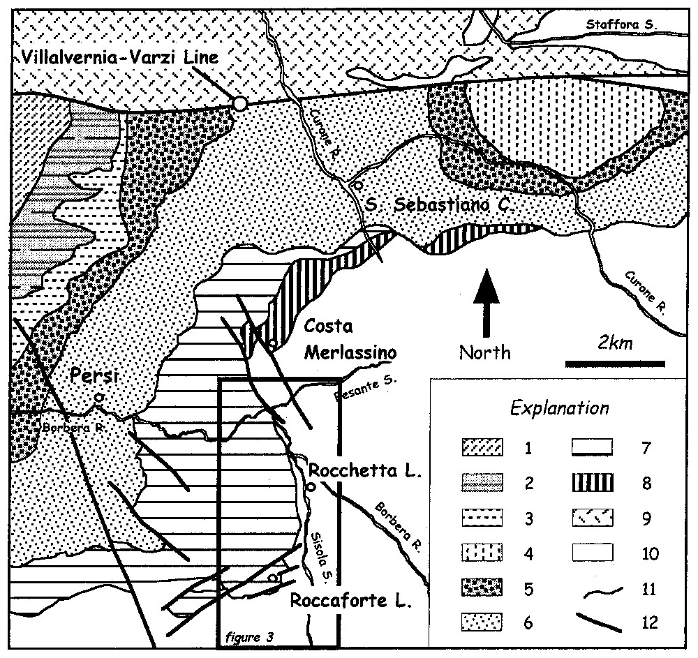
Geological sketch map of the middle Borbera Valley and surrounding areas. Explanation: 1: S. Agata Fossili Marl (Tortonian); 2: Serravalle Sandstone (Serravalian); 3: Cessole Marl (Langhian); 4: Castagnola Formation (Aquitanian); 5: Rigoroso Marl (Lower Oligocene–Aquitanian); 6: Monastero Formation (Lower Oligocene); 7: Val Borbera Conglomerate (Lower Oligocene); 8: Monte Piano Marl and Ranzano Sandstone (Middle Eocene–Lower Oligocene); 9: Undifferentiated Epiligurian Succession; 10: Liguride units; 11: stratigraphic boundaries; 12: faults.
Schéma géologique de la moyenne vallée de la Borbera et des zones environnantes. 1 : Marnes de S. Agata Fossili (Tortonien) ; 2 : grès de Serravalle (Serravallien) ; 3 : marnes de Cessole (Langhien) ; 4 : formation de Castagnola (Aquitanien) ; 5 : marnes de Rigoroso (Oligocène inférieur–Aquitanien) ; 6 : formation de Monastero (Oligocène inférieur) ; 7 : conglomérats de la Val Borbera (Oligocène inférieur) ; 8 : marnes de Monte Piano et grès de Ranzano (Éocène moyen–Oligocène inférieur) ; 9 : succession épiligure non différenciée ; 10 : unités ligures ; 11 : limites stratigraphiques ; 12 : failles.
3 Déformation polyphasée dans la moyenne vallée de la Borbera
Un relevé géologique de détail et des analyses structurales à l'échelle de l'affleurement ont été effectués au niveau de la vallée de la Borbera, entre Rocchetta Ligure et Cantalupo Ligure, ainsi que le long de la vallée Sisola. La carte géologique structurale obtenue est caractérisée par la présence de deux phases de plissement D1 et D2, cette dernière ayant intéressé à la fois les conglomérats de la Val Borbera et la succession-flysch du Monte Antola–formation de Pagliaro (Fig. 3). Le degré métamorphique qui caractérise D1 et D2 se situe au passage diagenèse–anchizone [3].
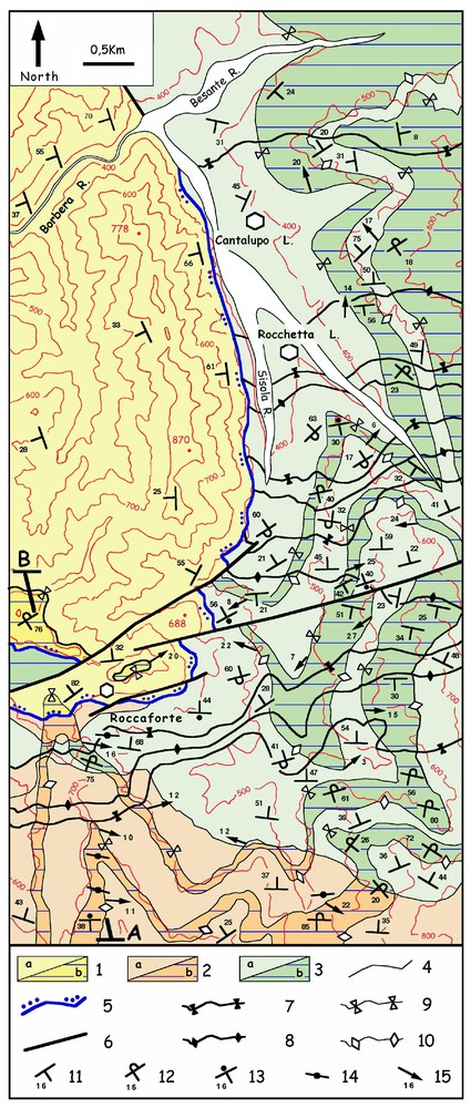
Detailed geological structural map of the studied area. Explanation: 1a, b, Val Borbera Conglomerate; 2a, b, Pagliaro Formation; 3a, b, Antola Flysch (a and b indicate respectively the normal and overturned F2 limbs); 4, stratigraphic boundaries; 5, unconformities; 6, faults; 7, F1 syncline axial plane; 8, F1 anticline axial plane; 9, F2 syncline axial plane; 10, F2 anticline axial plane; 11, normal beds; 12, overturned beds; 13, undetermined beds; 14, vertical beds; 15, F2 axes; A, B, location of the cross section represented in Fig. 4.
Carte géologique et structurale de détail de la zone étudiée, avec localisation de la coupe géologique représentée sur la Fig. 4 (A, B). 1a, b, Conglomérats de la Val Borbera ; 2a, b, formation de Pagliaro ; 3a, b, flysch du Monte Antola (a et b indiquent respectivement les flancs normaux et renversés des plis F2) ; 4, limites stratigraphiques ; 5, discordance basale des conglomérats de la Val Borbera ; 6, failles ; 7, plans axiaux des synclinaux F1 ; 8, plans axiaux des anticlinaux F1 ; 9, plans axiaux des synclinaux F2 ; 10, plans axiaux des anticlinaux F2 ; 11, stratification normale ; 12, stratification renversée ; 13, stratification indéterminée ; 14, stratification verticale ; 15, axes des plis F2.
Ces structures ont été représentées sur la carte par les plans axiaux des plis F1 et F2, auxquels ont été associées direction et inclinaison des axes (Fig. 3).
L'histoire de la déformation peut être reconstituée de la façon suivante.
La première phase de plissement se caractérise par des plis fermés à sub-isoclinaux F1, à géométrie parallèle, avec des axes assez dispersés, bien que la direction est–ouest semble prévaloir. Les charnières indiquent une vergence des plis F1 vers le nord. La phase D1 est toutefois bien documentée par la présence de flancs kilométriques de plis renversés, recouverts en discordance par les conglomérats de la Val Borbera. Plus particulièrement, la zone examinée est caractérisée par plusieurs couples d'anticlinaux et synclinaux impliquant le flysch du Monte Antola et la formation de Pagliaro (Figs. 3 et 4). Les structures sont scellées par la discordance basale des conglomérats de la Val Borbera, qui recoupent les traces des plans axiaux des plis F1 (Fig. 3).
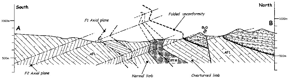
Geological cross-section across the polyphase folding of the middle Borbera Valley. For location, see Fig. 3. VBC: Val Borbera Conglomerate; PFM: Pagliaro Formation; AFL: Antola Flysch.
Coupe géologique des plissements polyphasés de la moyenne vallée de la Borbera. Voir la Fig. 3 pour la position. VBC : Conglomérats de la Val Borbera ; PFM : formation de Pagliaro ; AFL : flysch du Monte Antola.
La deuxième phase de plissement est représentée par des plis fermés à ouverts, asymétriques, à géométrie parallèle, qui affectent les plis F1 et leurs plans axiaux, tout comme les conglomérats de la Val Borbera (Figs. 3 et 4).
L'analyse de la superposition des phases de plissement dans le secteur méridional de la zone étudiée indique une interférence de type 3 de Ramsay [22] (Fig. 4).
Les axes des plis F2 sont concentrés autour de la direction ESE–WNW dans les zones méridionales, autour de NNW–SSE dans les zones septentrionales, tandis que les axes sont autour de NE–SW dans une zone centrale (Figs. 3 et 5) ; la vergence des plis F2 y est respectivement dirigée vers le NNE, le WNW et le nord-ouest. Par conséquent, en supposant que la direction « apenninique » ESE–WNW soit la direction axiale d'origine, la variation des axes des plis F2 peut être due à une rotation anti-horaire progressive. Les données structurales rassemblées jusqu'ici dans la vallée de la Borbera ne permettent pas d'établir si la rotation des axes des plis F2 est contemporaine ou postérieure à la formation des plis.

F2 fold axes distribution.
Distribution des axes des plis F2.
Étapes de la déformation
Les plis F1 se sont développés avant l'Oligocène inférieur, âge du dépôt des conglomérats de la Val Borbera, non impliqués dans cette déformation. À l'échelle régionale, les plis F1, qui intéressent l'unité Antola en moyenne vallée de la Borbera, sont liés à la collision continentale de l'Apennin septentrional à l'Éocène moyen (phase méso-alpine ou phase ligure, [8]).
Après la première phase D1, l'unité Antola et les autres unités ligures ont été exhumées et érodées, à la suite d'une tectonique d'extension, caractérisée par des failles normales et/ou transtensives, qui se seraient développées à l'Éocène terminal–Oligocène inférieur.
La phase D2, au contraire, est post-Oligocène inférieur, âge des conglomérats de la Val Borbera, puisqu'elle intéresse cette formation. Dans tout le secteur oriental du TPB, les plis F2, qui impliquent la formation de Monastero [13] et les marnes de Rigoroso, sont scellés par la formation de Castagnola [2] du Miocène inférieur (Aquitanien, [5]). La phase D2 se serait donc développée à l'Oligocène supérieur–Miocène inférieur, comme on l'a également suggéré pour le secteur central du TPB [21].
4 Conclusions
Les résultats obtenus indiquent donc que la partie inférieure de la succession orientale du TPB (conglomérats de la Val Borbera) a été déformée par une phase D2 à l'Oligocène supérieur–Miocène inférieur. Cette phase a produit des plis renversés F2 à direction allant d'ESE–WNW à NNW–SSE. Ces plis se superposent aux structures F1 de la phase D1 (Éocène moyen) qui a intéressé uniquement l'unité Antola.
La présence de structures de plissement qui affectent le TPB suggère que les rapports entre Alpes et Apennins ont été réactivés à l'Oligocène supérieur. Cette réactivation, qui a probablement engendré les diverses discordances associées à une tectonique syn-sédimentaire au sein du TPB, implique une variation des structures acquises par la zone de contact Alpes–Apennins durant les phases tectoniques méso-alpines. Selon Piana et Polino [20] et Schumacher et Laubscher [24], cette déformation peut être interprétée comme le résultat superficiel d'un chevauchement paléo-apennin, le long duquel le soubassement métamorphique alpin a recouvert les unités ligures.
1 Introduction
The central Liguria (northern Apennines, Italy) represents a complex geological area where the connection between Ligurian Alps and Northern Apennines occurs (Fig. 1; [9,23]). The deformation history of this area has been achieved from Late Cretaceous to Neogene timespan during the convergence and the subsequent continental collision between European and Adrian plates. The features of this deformation history are able to provide valuable constraints for the tectonic evolution of the linkage between the Alps and Apennines (cf. ‘Ligurian Knot’ of Laubscher et al. [15]).
Central Liguria is characterised by a tectonic setting where the oceanic- and continental-derived units, already deformed during the pre-Oligocene, are unconformably covered by a thick sedimentary succession deposited from Late Eocene to Late Miocene in an episutural basin, known as the Tertiary Piedmont Basin (thereafter referred as TPB). The TPB is generally regarded as an undeformed basin deposited over the deformed Apennine and Alpine Units.
In this paper, a structural study performed in the middle Borbera Valley (central Liguria), is provided in order to describe a polyphase folding history, developed at the upper structural levels and affecting also the TPB succession.
2 Geological setting
The top of the northern Apennines nappe pile is represented by the Liguride Units, which include fragments of the Ligurian-Piedmontese oceanic basin and its transition to Adrian continental margins. These units were thrust during the Oligocene and Miocene onto the more external domains belonging to the Adrian continental margin (Tuscan–Umbrian domain). The Liguride units are characterised by an assemblage of Jurassic ophiolite sequences and related sedimentary successions ranging in age from Late Jurassic to Middle Eocene (e.g., [17,18]). These units were strongly deformed during Eo- and Meso-Alpine tectonic phases that record oceanic closure and subsequent continental collision. The Liguride Units are separated to the west from the HP/LT metamorphic oceanic-derived units, known as Voltri Group, by the Sestri–Voltaggio fault zone. The Voltri Group is regarded as belonging to the western Alps structural domain. In this area, the complex structural setting and the thick sedimentary cover of TPB hamper a clear definition of the relationships between the Alpine and Apennine units. Recent studies on the deep structures of the Alpine–Apennine linkage area, mainly based on geophysical data [15,20,24], indicate that in the subsurface of the Langhe and Monferrato areas, located northwesternmost of central Liguria (Fig. 1), the Apennine Liguride Units are largely overridden by the Alpine units. At present, however, the timing, lateral extension and surface expression of these north-vergent, deep-seated thrusts are not clearly defined. Since the Late Eocene, the TPB developed over the Alpine and Apennine units as part of a wider episutural basin known as epi-Mesoalpine Basin [19]. The TPB seals the Eo- and Meso-Alpine deformations acquired by different tectonic units from Ligurian Alps (e.g., Voltri Group and Briançonnais units) to northern Apennines (Liguride Units).
In this setting, the deposits of the eastern part of the TPB preserve the record of the tectonic events occurred after the Meso-Alpine phase in central Liguria. This tectonic setting can be clearly detected in the Borbera Valley, where the sedimentary succession of the eastern sectors of the TPB unconformably overlays the Antola Unit, which represents the structurally uppermost Liguride Unit (Fig. 1).
Whereas polyphase folding has been recognised in the Antola Unit [25], the eastern TPB succession has been generally described as undeformed and the geological studies have been mainly focused on the stratigraphical and sedimentological features of these deposits ([19] and quoted references).
The studied Borbera Valley area is characterised by the occurrence of the basal unconformity surface between the TPB succession and the underlying Antola Unit (Fig. 2). In this area the Antola Unit is represented by the Mt. Antola flysch and Pagliaro Formation. The Mt. Antola Flysch is a typical upper Campanian-Maastrichtian Helminthoid Flysch made up of thick, fine-grained calcareous turbidites, interbedded with thin, silty turbidites. The Pagliaro Formation (Early Palaeocene [18]) mainly consists of arenaceous–pelitic and subordinately calcareous turbidites alternating with hemipelagic shales. The basal part of the TPB succession in this area is represented by the Val Borbera Conglomerate, consisting of an up to 2500 m thick succession of continental to marine conglomerates of Early Oligocene age [10,12,14]. The compositional change in the conglomerates is regarded as the witness of the progressive exhumation of the Alpine and Apennine nappe pile until the erosion of the deeper levels, i.e. the Voltri Group [7]. Locally (Costa Merlassino area; Fig. 2), the lowermost part of the TPB succession (Monte Piano Marl and Ranzano Sandstone; [19] and references therein) is preserved between the Val Borbera Conglomerate and the Antola Unit. The Val Borbera Conglomerate grades upward to a predominantly arenaceous-pelitic succession of frankly marine and progressively deeper deposits, as a consequence of a regional transgression [16]. However, the activity of synsedimentary faults during this phase was responsible for the development of local depocentres, recorded by the complex depositional geometry and facies associations of the overlying units. In this setting, the Lower Oligocene Monastero Formation, the Oligocene to Aquitanian Rigoroso Marl and the Aquitanian Castagnola Formation were deposited [1,5]. Starting from the Burdigalian, the eastern part of the TPB was characterised by a progressive uplift, as suggested by the basal unconformity of shelfal deposits of the Cessole Marl (Langhian). This phase of uplift was still active during the deposition of the shallow marine Serravalle Sandstone (Serravallian). Eventually, a regional transgressive phase is recorded by the shelfal deposits of the S. Agata Fossili Marl (Tortonian) [11].
3 The polyphase folding in the middle Borbera Valley
Detailed field mapping and analysis of the outcrop-scale structures have been carried out in the Borbera Valley (Fig. 3), between Rocchetta Ligure and Cantalupo Ligure, and along the Sisola Valley. The resulting geological-structural map is characterised by the occurrence of two folding phases (D1 and D2), the younger one affecting both the Val Borbera Conglomerate and the Mt. Antola Flysch and Pagliaro Formation (Fig. 3). The D1 and D2 folding phases developed under diagenesis/anchizone boundary conditions [3], typical for the deformation at upper structural levels in the orogenic belts.
A representation of these structures on the structural map has been done using the trend of the axial surfaces belonging both to F1 and F2 folds, associated with strike and dip of the related fold axes (Fig. 3).
3.1 Reconstruction of the deformation history
3.1.1 D1 folding phase
The D1 folding phase structures are represented by tight to subisoclinal F1 folds with scattered axes trend, even if an east–west trend seems to be prevailing. The F1 folds show a parallel geometry, whereas thickening of the hinge zone or boudinage of the limbs have never been recognised. The axial plane foliation is a discontinuous surface that in the shaly and calcareous beds occurs only as a disjunctive cleavage. The outcrops showing the fold hinges are rare; the few examples recognised during the field mapping indicate a northward vergence for the F1 folds. However, the D1 folding phase is well documented by the occurrence of kilometric overturned fold limbs, unconformably covered by the Val Borbera Conglomerate. In particular, the studied area is characterised by several couples of anticlines and synclines that affected the Mt. Antola Flysch–Pagliaro Formation succession (Figs. 3 and 4). As reported in the geological map (Fig. 3), these structures are sealed by the basal unconformity of the Val Borbera Conglomerate that cuts across the traces of F1 axial surfaces (Fig. 4).
3.1.2 D2 folding phase
The D2 folding phase is represented by open parallel folds that affect all the F1 folds and the related axial surfaces as well as the Val Borbera Conglomerate (Figs. 3 and 4). The F2 folds are represented by open to tight overturned asymmetric folds, characterised by a parallel geometry. The analysis of the superposed folds in the southern sector of the studied area based on the geological cross-section of Fig. 4 indicates a type 3 interference pattern according to Ramsay [22].
The general trend of the F2 fold axes ranges from ESE–WNW in the southern areas to NNW–SSE in the northeastern ones, through a central zone where the axes are about NE–SW (Figs. 3 and 5). The F2 fold vergence in the three sectors is respectively toward the NNE, the WNW and the northwest. Therefore, assuming the ESE–WNW ‘apenninic’ trend as the original axial direction, the change of the F2 fold axes can be related to a gradual anticlockwise rotation. The observed change in F2 trend reflects the fold-axis dispersion that regionally characterises both the Liguride Units and the episutural basin deposits. An influence of strike-slip fault systems in the fold axis reorientations has been assumed [4], such as ductile axial torsion due to a possible gravitational mechanism of nappe emplacement [6]. The structural data up to now collected in the Borbera Valley do not allow to establish if the F2 fold-axis rotation is contemporary or successive to the fold formation.
3.2 Timing of deformation
The development of the first folding phase pre-dates the deposition of the Val Borbera Conglomerate, not affected by this deformation. Therefore, this phase is pre-Early Oligocene in age. At the regional scale the D1 phase identified in the Antola Unit of the middle Borbera Valley can be related to the collisional stage, i.e. the Ligurian or Meso-Alpine phase, of Middle Eocene age [8].
After the first folding phase, the Antola Unit as well as the others Liguride Units experienced large-scale exhumation and erosion. This event was probably linked with an extensional tectonics developed during the Late Eocene–Early Oligocene timespan, marked by normal and/or transtensive faults.
On the contrary, the D2 phase, which affects the Val Borbera Conglomerate, is post-Early Oligocene in age. Owing to lacking of well-exposed sections in the study area, it is difficult to assess the upper chronological constraint of the second deformation phase. However, the open north-verging folds described in the Scrivia Valley area [13] can be correlated with the F2 folds identified in the Borbera valley. In the whole easternmost sector of the TPB, these folds, which affect the Monastero Formation as well as the Rigoroso Marl, are sealed by the Lower Miocene Castagnola Formation [2]. By these constraints, the D2 folding phase can be related to a tectonic stage developed between the Late Oligocene and the Early Miocene, as also suggested by Piana et al. [21] for the central sector of the TPB.
4 Conclusions
The results of this study indicate that the structural setting of the lower part of the eastern TPB succession cannot be regarded as a monocline plunging toward the Po Plain. The collected data provide the evidences for the deformation of the Val Borbera Conglomerate by a D2 folding phase of Late Oligocene–Early Miocene age. This phase generated ESE–WNW- to NNW–SSE-trending overturned F2 folds. These folds are superimposed onto an early D1-folding phase of Middle Eocene age, which affects only the Antola Unit.
The occurrence of map-scale folding structures that affect the TPB suggests that the linkage area between Alps and Apennines was reactivated during the Late Oligocene–Early Miocene age. This reactivation, probably responsible of the unconformities and the related synsedimentary tectonics observed in the TPB succession, implies a modification of the structures acquired by the Alps–Apennines boundary during the Meso-Alpine tectonic phases. According to Piana and Polino [20] and Schumacher and Laubscher [24], this deformation can be correlated with the ‘palaeo-Apennines’ thrusting phase characterised by the emplacement of the Alpine metamorphic nappes onto the Liguride Units.
Acknowledgements
M. Durand-Delga and M. Vanossi are gratefully thanked for their constructive reviews. This research was supported by the Italian National Research Council (CNR, ‘Istituto di Geoscienze e Georisorse’) and by the Italian Ministry for University and Scientific and Technological Research (MURST).