

Version française abrégée
1 Introduction
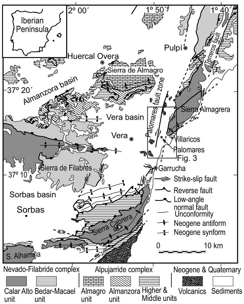
Le secteur sud-est des cordillères Bétiques est caractérisé par la présence de bassins sédimentaires dont l'âge va du Néogène au Quaternaire, le long d'une ligne de reliefs est–ouest à ENE–WSW, correspondant à des antiformes où affleure le socle métamorphique du domaine d'Alboran [20–22,35].
Cette orientation générale est–ouest est interrompue à l'est du bassin de Vera par la Sierra Almagrera, qui a une orientation NNE–SSW subparallèle à la zone de failles de Palomares (PFZ).
La zone de failles de Palomares [7–10] est formée d'une succession de segments de failles senestres d'orientation N10–N20, qui recoupent le bassin de Vera entre le corridor de Pulpi, au nord, et la ville de Garrucha, au sud (Fig. 1). Plusieurs auteurs considèrent cette zone comme un couloir de décrochement actif depuis le Miocène [1,24,30], avec un déplacement horizontal de l'ordre de 15 à 30 km [13,36].
Tectonic map of the southeastern Betics. Modified from Booth-Rea et al. [6].
Schéma structural du Sud-Est des cordillères Bétiques. D'après Booth-Rea et al. [6], modifié.
Dans cette étude, nous avons estimé l'épaisseur des unités sédimentaires appartenant au Tortonien terminal–Messinien, au Pliocène et au Quaternaire qui affleurent le long de la PFZ grâce à des données provenant de 80 puits forés par l'industrie minière. Ces données définissent l'architecture et la géométrie des dépocentres sédimentaires de la partie est du bassin de Vera, ainsi que leur relation avec la position et l'activité des segments de la PFZ entre le Tortonien terminal et nos jours.
2 Les unités sédimentaires du bassin de Vera
Le bassin de Vera est rempli par une série principalement marine, constituée par plusieurs unités sédimentaires dont l'âge s'échelonne du Miocène inférieur au Quaternaire [1,2,32–34]. Récemment, Barragán [2] a révisé la stratigraphie du bassin en établissant la succession des principales unités sédimentaires, dont certaines ont été déposées en relation avec l'activité de la PFZ :
Unité V (Tortonien supérieur). Elle est limitée à sa base par une discordance angulaire (discordance intra-tortonienne [14]) et repose indifféremment sur les sédiments des unités sous-jacentes ou directement sur le socle métamorphique. Elle est constituée de deux séquences sédimentaires de dépôts montrant un approfondissement croissant. La séquence inférieure est formée par des conglomérats de gros blocs, de sables et de silts dont le faciès est caractéristique d'environnements deltaı̈que et marin peu profonds. Cette séquence est recouverte par une série transgressive de marnes de mer ouverte, de calcaires marneux et de siltites à intercalations de turbiditites sableuses (formation Chozas [26]). Elle s'est déposée durant un épisode d'approfondissement enregistré dans la plupart des bassins des cordillères Bétiques ainsi que dans ceux de la mer d'Alboran [2,4,25].
Unité VI (Tortonien terminal–Messinien). Elle repose en discordance sur les unités sédimentaires miocènes plus anciennes (voir texte anglais). Cette unité (formation Turre [32]) est formée de deux membres. Le membre inférieur, appelé Azagador [32], est formé de carbonates de plate-forme. Ce faciès passe latéralement vers le bassin et verticalement à des marnes et silts formant le membre supérieur (appelé Abad [32]). Dans tous les forages étudiés, cette unité présente de fortes variations de pendage. De 30 à 45° à la base de la série dans le membre Azagador, le pendage passe vers le haut à des valeurs plus faibles, de l'ordre de 0 à 10°. Cette discordance progressive en éventail est génétiquement liée à la surrection de la Sierra Cabrera [1,2,4,24], au sud du bassin de Vera (Fig. 1).
Le membre Azagador comporte de grandes variations d'épaisseur, accompagnées par des changements de faciès. On trouve en effet dans cette unité des sédiments tels que du détritique fin de bassin, avec des épaisseurs importantes (jusqu'à 300 m, par exemple, aux forage P-11 et A1-42, Figs. 2 et 3A) et des conglomérats continentaux à clastes portés, d'épaisseur plus modeste, entre 20 et 30 m (forage A1-4, Fig. 2).
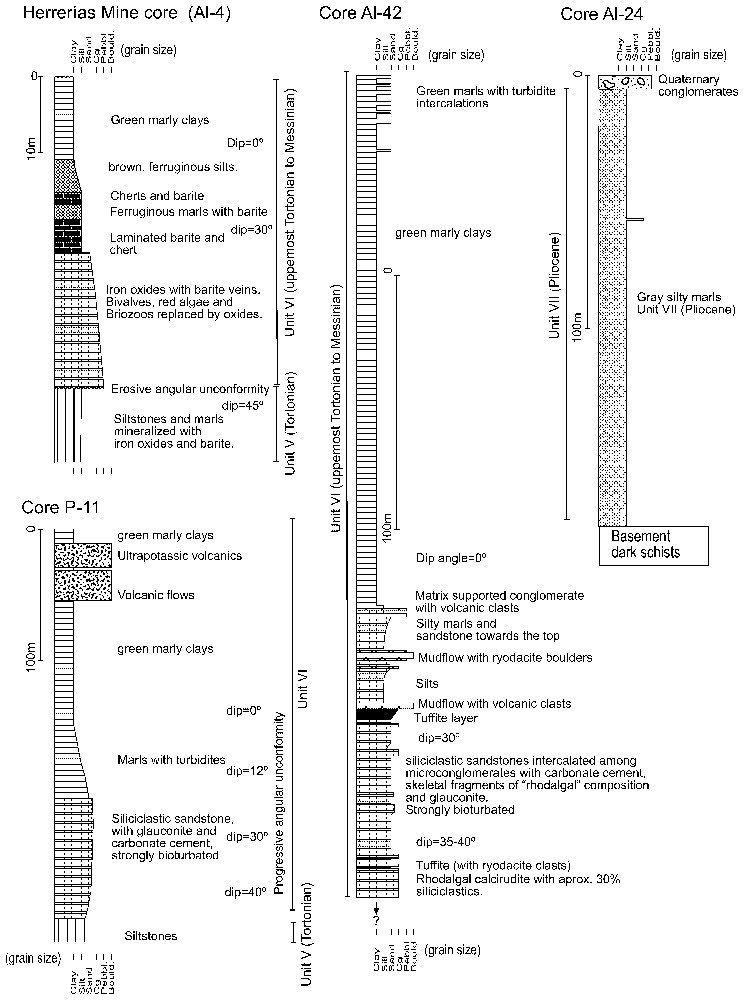
Drill cores representative of the sedimentary infill along the PFZ. Cores situated in Fig. 3A.
Forages de la couverture sédimentaire dans le PFZ. Situation des forages, voir Fig. 3A.
Thickness distribution (in metres) of the Uppermost Tortonian to Messinian, Pliocene and Quaternary sedimentary units in the studied area. UTM geographical projection. Area located in Fig. 1.
Épaisseurs (en m) des unités sédimentaires du Tortonien terminal, du Messinien, du Pliocène et du Quaternaire. Projection géographique UTM. Situation géographique, voir Fig. 1. Points noirs (3A, 3B) : sondages.
Unité VII (Messinien terminal-Pliocène). Cette unité a été déposée après la crise de salinité du Messinien [18]. Localement, sa base est formée par des conglomérats à matrice porteuse comportant des blocs de gypse (gypse détritique) et de turbidites héritées de la sous-unité Abad sous-jacente. Aussi, est-il possible de trouver des travertins, des conglomérats continentaux ou encore des calcarénites, déposés sur un socle irrégulier et érodé durant la crise messinienne. Cette séquence basale est recouverte par une série transgressive de marnes grises et de marnes silteuses marines de la formation Cuevas [1,2] atteignant localement une épaisseur de plusieurs centaines de mètres (forage A1-2, Fig. 2). Le terme supérieur de cette unité, dont la base a été datée du Pliocène inférieur terminal, est composé par un conglomérat déposé dans un environnement de transition de type deltaı̈que.
Sédiments quaternaires. Durant le passage Pliocène–Pléistocène, se sont déposés des grès et conglomérats marins peu profonds et continentaux au nord-est de la zone étudiée dans le bassin de Vera [31]. Les derniers dépôts dans cette zone sont les terrasses fluviatiles du Pléistocène-Holocène situées entre les villes de Vera et de Palomares (Fig. 1), près de l'embouchure du Rio Almanzora.
3 Segmentation de la zone de faille de Palomares
Plusieurs segments de la PFZ traversent le bassin de Vera. Le segment le plus occidental, situé dans la région de Garrucha, peut être suivi vers le nord jusqu'à la ville de Pulpı́.
Ces segments de faille affectent les conglomérats estuariens du Pliocène supérieur de l'unité VII et sont scellés par les terrasses fluviatiles quaternaires [2]. Vers le sud, à l'est de Garrucha, plusieurs segments de failles sont directement scellés par les termes de l'unité VII, montrant donc une activité anté-Pliocène. La puissante série sédimentaire messinienne est préservée dans le bloc le plus occidental des segments de la zone de faille, où elle atteint plus de 300 m de puissance (Fig. 3).
Les segments les plus orientaux de la zone de faille limitent à l'ouest la Sierra Almagrera. Le plus important d'entre eux est le segment d'Arteal (Fig. 3) dont le jeu sénestre-normal produit une subsidence tectonique importante. D'autres segments d'importance plus modeste sont situés entre les segments de Palomares et d'Arteal : c'est le cas, par exemple, du segment de faille d'Herrerias (Fig. 3), qui présente un jeu sénestre inverse.
Il existe, entre les failles de Palomares et d'Arteal, une accumulation sédimentaire importante (dépocentre), dont l'orientation est sensiblement méridienne. Celle-ci est constituée principalement de marnes silteuses pliocènes de l'unité VII, localement recouvertes par les conglomérats estuariens pliocènes et, plus au sud, par les terrasses fluviatiles quaternaires. Ce dépocentre suit la direction des segments de failles de Palomares et d'Arteal, atteignant son épaisseur maximale (plus de 250 m de Pliocène) près du segment d'Arteal (Fig. 3B). Un autre dépocentre pliocène moins important est préservé à l'ouest du segment de faille de Palomares (Fig. 3), où les marnes silteuses pliocènes ont basculé de 15 à 20° vers la faille. Les sédiments quaternaires sont situés principalement au sud du dépocentre oriental, près du segment de faille d'Arteal où ils atteignent leur épaisseur maximale (Fig. 3D). Ce dépocentre est orienté NW–SE et semble être contrôlé par une faille dextre (N110–120°E), probablement conjuguée à la faille de Palomares. Les segments de la faille de Palomares situés le plus à l'ouest de Garrucha ne recoupent pas la structure antiforme de la Sierra Cabrera. La déformation semble y être accommodée par des failles inverses situées sur la marge nord de cette sierra (Fig. 1). Par ailleurs, la faille d'Arteal et d'autres segments de failles comme celui de Terreros (situé à l'est de la Sierra Almagrera) se prolongent en mer d'Alboran et recoupent clairement la Sierra Cabrera, en la décalant vers le nord, où elle prend le nom de Sierra Almagrera [4,6,36] (Fig. 1).
4 Discussion
Le déplacement le long de la PFZ s'est effectué grâce à un jeu sur différents segments affleurant actuellement dans la dépression du bassin de Vera. Nous avons interprété la discordance progressive du Tortonien terminal comme la plus ancienne manifestation de la PFZ. Vers le sud, cette discordance change en prenant une orientation est–ouest parallèle à l'antiforme de la Sierra Cabrera, où elle est liée à une faille inverse à déplacement nord-ouest (Fig. 1). À l'ouest de Garrucha, quelques segments de la faille de Palomares sont fossilisés par les sédiments pliocènes. Le fait que les sédiments messiniens soient principalement localisés sur le bloc occidental du segment de faille de Palomares, où ils atteignent leur épaisseur maximale (Fig. 3), pourrait indiquer que l'essentiel du déplacement le long de la PFZ a été accommodé sur ce segment durant le Messinien. Nous proposons que la PFZ ait été initialement une faille de transfert liée au plissement et à la surrection de la Sierra Cabrera, au passage Tortonien supérieur–Messinien, avec chevauchement et plissement dans la zone de Ramonete–Tébar [17], située au nord-est du bassin de Vera.
Alors que le segment de faille de Palomares était actif durant le Pliocène, la déformation et le déplacement ont migré vers l'est, formant de nouveaux segments de faille, comme celui d'Arteal, favorisant l'apparition d'un nouveau dépocentre, où la plupart des sédiments pliocènes et quaternaires se sont accumulés. L'activité le long du segment d'Arteal et d'autres failles d'importance plus modeste, comme le segment d'Herrerı́as, s'est prolongée durant le Quaternaire, conditionnant la topographie de la Sierra Almagrera et créant une subsidence tectonique importante depuis le Quaternaire jusqu'à nos jours.
1 Introduction
The southeastern Betics are characterized by the presence of Neogene to Quaternary sedimentary basins that outcrop among east–west- to ENE/WSW-elongated mountain ranges, which coincide with antiformal highs where metamorphic basement of the Alboran domain outcrops [20–22,35]. These basins were initiated by extensional tectonics that greatly attenuated the previous Palaeogene Betic Orogen during the Lower and Middle Miocene [5,15,16,20], in an evolution parallel to that of the formation of the Alboran Sea [12]. However, the basins were folded and uplifted during Upper Neogene to Quaternary north–south to NW–SE convergence [9,14,22,35]. This is the case of the Sorbas–Vera basin, which is located between the Sierra de Filabres to the north and Sierra Alhamilla and Sierra Cabrera to the south (Fig. 1).
The Upper Neogene sedimentary cover of these basins was deposited coeval to the anticlines formation, thus showing synformal geometries with their maximum thicknesses distributed parallel to the anticlines axes. In the case of the Sorbas–Vera Basin, a progressive unconformity in the sedimentary cover dates the submarine uplifting of the Alhamilla–Cabrera Sierras as mostly Uppermost Tortonian [2,4,35]. However, thrusts, folds and strike-slip faults that affect Lower Tortonian sediments are locally sealed by Tortonian deposits in the northern foothills of Sierra Cabrera, hence, structures developed under Neogene convergent tectonics were active during most of the Tortonian in the Sorbas–Vera Basin [1,2,4,22,24].
The east–west-oriented topographical and geological grain is interrupted to the east of the Sorbas–Vera Basin by the Sierra Almagrera mountain range, which has a NNE–SSW orientation, subparallel to the Palomares Fault Zone (PFZ) that bounds the Vera Basin to the east (Fig. 1).
The PFZ [7–10] is formed by sinistral fault segments with N10–20°E orientation that were active during the Pliocene and Quaternary, cutting the Vera basin between the Pulpı́ corridor to the north and Garrucha to the south (Fig. 1). Further works referred to this fault zone as a transcurrent corridor that was active during most of the Miocene and Quaternary [1,23,29], producing a large horizontal displacement of 15 to 30 km [13,36].
In this work we have estimated the thickness of the Uppermost Tortonian to Quaternary sedimentary units that outcrop along the PFZ with data from 80 cores drilled by the mining industry in the area, together with information of the intersection of the base of the sedimentary units with topography. These data define the stratigraphic architecture and geometry of the sedimentary depocentres found in the eastern Vera Basin and their relationship with the position and activity of the segments of the PFZ between the Uppermost Tortonian and the Quaternary.
2 Sedimentary units of the Vera Basin
The Vera basin has a mostly-marine sedimentary cover constituted by Lower Miocene to Quaternary sedimentary units [1,24,32–34]. Recently, Barragán [2] revised this basin, defining its main sedimentary units. From bottom to top these are the following units.
- – Unit I (Burdigalian) is formed by pelagic limestones and marls that show an upward shallowing sequence.
- – Unit II (Upper Burdigalian to Lower Langhian) lies unconformably upon the previous unit and shows a larger facies variability, deposited under shallow marine and continental environments. It shows a summerizing sequence from marine calcirudites and sandstones with intercalated marls towards continental red shales and conglomerates.
- – Unit III (Upper Langhian to Serravallian) also defines a shallowing-up cycle with great facies variability, from open marine turbidites at the base to red continental conglomerates on the top.
- – Unit IV (Lower Tortonian) has two depositional sequences, the lower one represented by silts, sandstones and marls of shallow marine environments and the upper one by red continental conglomerates. Both the Serravallian (U. III) and Lower Tortonian red conglomerates (U. IV) are similar, except for the provenance of their clasts. Unit IV includes clasts from the lowest metamorphic terrains, the Nevado-Filabride complex and the Almagro unit [2]. Previous authors frequently included both these red conglomerates in a single unit, called Tortonian I [1,22–24]. Unit IV is badly represented in the study area [2], as in the rest of the Betics and Alboran Sea where it frequently coincides with an erosive unconformity [14,25]. This intra-Tortonian unconformity is related with the first structures formed during Neogene convergence, folds and reverse faults, in many of the Betic Basins [5,14,23].
- – Unit V (Tortonian) is bounded at its base by an angular unconformity (intra-Tortonian unconformity [14]) and lies on the previous sedimentary units or directly upon the metamorphic basement. It has two depositional sequences that show a deepening-upwards cycle. The lowest sequence is formed by conglomerates with large boulders, sandstones and silts characteristic of deltaic and shallow marine conditions. This sequence is covered by transgressive open-marine marls, marly limestones and siltstones with sandy turbidite intercalations (Chozas Formation [26]) deposited during a deepening event that was registered in most of the Betic basins and in the Alboran Sea [2,4,25].
- – In Unit VI (Uppermost Tortonian to Messinian), the Chozas Formation is overlain unconformably by the so-called Azagador Member of the Turre Formation [32]. The Azagador Member is a platform deposit constituted by bioclastic-carbonate and mixed siliciclastic-carbonate sediments with biotic associations typical of a temperate climatic setting [11]. Basinwards, the Azagador member passes laterally to basinal silts, siliciclastic silty sandstones and marls (Abad Member of the Turre Formation [32]. In core Al-42 (Fig. 2), intercalated among the Azagador sandstones, there are two dark levels that include dacite clasts (Mazarron group [3]) that we have interpreted as tuffite layers, thus calc-alkaline (Mazarron type) volcanics erupted during the deposition of the Azagador member in the Uppermost Tortonian. Several of the studied cores show that Abad marls corresponding to the transgressive systems tract on-lap straight upon the calc-alkaline volcanic rocks that outcrop in the Vera Basin. In all the studied cores, Unit VI shows a strong variation in the bedding dip angle, normally dipping 30–45° at the base of the Azagador Member and between 10 and 0° at the top of Unit VI in the Abad Member. This fan-like progressive unconformity has been genetically related with uplifting of Sierra Cabrera [1,2,4,24] to the south of the Vera Basin (Fig. 1). It is also probably related with the initial activity of the PFZ as this unconformity is found all along the Palomares fault trace from Garrucha towards the north. Great thickness variations related with the progressive unconformity are found in this unit, which reaches between 20–30 m (core Al-4, Fig. 2) and more than 300 m (cores P-11 and Al-42, Fig. 2). These thickness variations are accompanied by changes in the facies of the Azagador member from basinal siliciclastic facies in the thickest cores (for example P-11, Fig. 3) to continental clast-supported conglomerates, locally found between the Upper Tortonian Chozas marls and the Messinian Abad marls. To the northwest of the Vera Basin, above the Abad marls there are reefs and yellow marls with diatomites deposited during the highstand systems tract [2,11] prior to the Messinian salinity crisis that affected the Mediterranean [18].
- – Unit VII (Latest Messinian to Pliocene) deposited after the Messinian salinity crisis event. This event is represented by an erosive and angular unconformity in most of the Vera basin, and locally by lacustrine facies to the north [2,4]. The base of this unit is formed by matrix-supported conglomerates with gypsum boulders and clasts from the underlying Turre Formation, and locally by travertines, continental conglomerates, and calcarenites, which were deposited on an irregular basement strongly eroded during the Upper Messinian emersion. Transgressive marine grey marls and silty marls of the Cuevas formation overlay this shallow-marine basal sequence [32,34], these marls locally reach a thickness of several hundred metres (core Al-22, Fig. 2). Unit VII is caped by conglomerates deposited in transitional environments (deltaic, shallow marine, fluvial [2]) the base of which has been dated as uppermost Lower Pliocene [2].
- – Upper-Pliocene to Quaternary sediments: extensive Pliocene–Pleistocene, shallow marine to continental conglomerates accumulated to the northeast of the study area in the Vera Basin [31]. Pleistocene and Holocene river terraces cap the sedimentary cover to the southeast of the study area between Vera and Villaricos (Fig. 1) near the mouth of the Almanzora River. To the east of Palomares along the Almanzora River the related conglomerates reach above 50 m thick (data from mining cores in the area, Fig. 3).
3 Segmentation of the Palomares fault zone
The PFZ shows several fault segments that cut the Vera Basin. The westernmost segments outcrop to the west of Garrucha and can be followed towards the north almost up to Pulpı́ ([10], Fig. 1). They fault the Upper Pliocene conglomerates of Unit VII and are mostly sealed by Quaternary river terraces [2]. However, they cut Quaternary beach deposits in Garrucha [10]. Bousquet et al. [10] describe other outcrops were Quaternary conglomerates are cut by the westernmost Palomares fault segments; however, these conglomerates have been dated recently by electron spin resonance (ESR) as older than 1.6 Ma by Wenzens [37]. Hence, Quaternary activity attributed to some of the westernmost Palomares fault segments was actually post-Upper Pliocene. Unit VII seals the southernmost Palomares fault segments, to the west of Garrucha, demonstrating the activity of the PFZ before the Pliocene. The thickest Messinian sedimentary sequence is preserved in the western block of the Palomares fault segments, where Unit VI reaches up to 300 m (Fig. 3A).
The eastern fault segments of the PFZ bound Sierra Almagrera to the west. The most important of these is the Arteal fault (see Fig. 3) named after a mine that exploited Zn, Ag, Pb, and Ba mineralisations found along the fault trace, with textures (implosive breccias [27]) that prove that these mineralisations developed by fault-valve behaviour [28] with coseismic manifestations. The Arteal fault dips 45–60° towards the West and has striae that plunge 15 to 25°S, thus having a sinistral-normal regime, which produced an important tectonic subsidence during the fault activity.
Other smaller fault segments are found between the Palomares and the Arteal faults, for example, the Herrerı́as fault (Fig. 3), which has a sinistral-inverse regime. This fault cuts Quaternary conglomerates and has a displacement of approximately 150 m (striae dip 20–26°; vertical displacement of 60 m).
Between the Palomares and the Arteal faults, there is an important north–south-oriented sedimentary depocentre filled mostly by Pliocene silty marls that on-lap straight upon the metamorphic basement, although they also overlay previous sedimentary units defining an angular unconformity. Upper Pliocene conglomerates, and towards the south Quaternary and Holocene conglomerates cap the sedimentary sequence. This depocentre follows the trace of both the Palomares and Arteal faults and it has its maximum thickness (more than 250 m of Pliocene sediments) near the Arteal fault (see Fig. 3B).
A narrower and shallower Pliocene depocentre is preserved to the west of the Palomares fault segments (Fig. 3) where the Pliocene silty marls are tilted 15–20° towards the fault trace.
Quaternary sediments are found mainly to the south of the eastern depocentre with their maximum thickness near the trace of the Arteal fault. They show northwest/southeast-oriented smaller depocentres bounded by dextral faults conjugate to the Palomares one, with N110–120°E orientation. Displacement along the Herrerı́as fault seems to be accommodated by one of these dextral faults that bounds the outcrops of unit VII to the north of Herrerı́as and connects the Herrerı́as fault with the Palomares one (Fig. 3B).
Although the Palomares fault segment is sealed by Quaternary sediments, the base of these is situated at different depths on both blocks of this fault (Fig. 3C) being elevated in the western block where they do not reach a thickness above 10 m. Hence, the Palomares fault segment was active during part of the Quaternary although with a different regime (sinistral inverse) than during the Uppermost Tortonian to Pliocene when uplift affected the eastern fault block.
The southern segments of the Palomares fault, found to the east of Garrucha, do not cut the anticline structure of Sierra Cabrera. They merge with inverse faults found in the northern limb of this anticline, hence, having accommodated part of their sinistral displacement with uplift and folding of Sierra Cabrera during the Uppermost Tortonian and Messinian. Meanwhile, the Arteal fault and other fault segments near Garrucha [10] prolong towards the Alboran Sea, cutting the Sierra Cabrera anticline, which they have rotated and displaced towards the North in Sierra Almagrera, which shows a structure equivalent to that of Sierra Cabrera (Fig. 1) [6].
4 Discussion
Displacement along the PFZ has taken place along different fault segments that outcrop in the Vera depression [4,10,36]. We have interpreted the Uppermost Tortonian progressive unconformity found in the Azagador member as the oldest manifestation of the PFZ activity, as this unconformity follows the orientation of the Palomares fault between Garrucha and the most northern drill-holes studied in this work. Towards the south this unconformity changes towards an east–west orientation parallel to the Sierra Cabrera anticline, where it is related with northwest-transport inverse faults (Fig. 1).
Pliocene sediments seal the Palomares fault segments, to the west of Garrucha, confirming the Messinian activity of this fault. The fact that Messinian sediments, found along the trace of the PFZ, are mostly confined to the western block of the Palomares fault where they reach their maximum thickness (Fig. 3A) could indicate that most of the Messinian displacement along the Palomares fault zone was accommodated by it's westernmost segments. According to previous authors, the PFZ would have been active before the Uppermost Tortonian [1,24,36]. However, some of the sediments considered of Uppermost Tortonian age, formed by shallow marine conglomerates including mostly clasts of Upper Tortonian sandstones and siltstones, which seal the southern segments of the PFZ have been recently interpreted as Lower Pliocene beach sediments deposited along the trace of the western Palomares fault segments, upon the Messinian ‘salinity crisis’ erosional surface [2]. Consequently we have not found any evidence of pre-Uppermost Tortonian activity of the PFZ. Although, contractive structures (reverse faults and folds with NW vergence) are sealed by Tortonian sediments in the northern foothills of Sierra Cabrera [4], which date the earliest convergent structures developed after well documented Lower and Middle Miocene extensional tectonics in the Internal Betics [4,5,12,15,16,20,21]. The Tortonian NW–SE convergence would constitute a reasonable tectonic scenario for the activity of the PFZ during the Tortonian, as proposed by several authors [1,13,24,36].
We propose that the PFZ initiated as a transfer fault relating the folding and uplift of Sierra Cabrera in the Upper Tortonian and Messinian with thrusting and folding to the northeast of the Vera Basin, probably within the Ramonete–Tébar zone [17]. Later, although the Palomares fault segment was active during the Pliocene and Quaternary, deformation migrated towards the east forming the Arteal fault segment, which favoured the formation of a new sedimentary depocentre, where most of the Pliocene–Quaternary sediments accumulated. Activity along the Arteal fault and other minor faults like the Herrerı́as fault continued during the Quaternary, uplifting Sierra Almagrera and producing tectonic subsidence of the western block of the Arteal fault.
The Pliocene displacement of the Palomares fault cut the Uppermost Tortonian folds, propagating the deformation outwards, towards other structures found further north and south, for example the Carboneras fault [19] and the Alhama de Murcia fault [23,29] respectively, which were active during the Upper Neogene–Quaternary.
Acknowledgements
The MCYT Spanish projects REN2001-3868-CO3-01/MAR and REN2001-3378, and FEDER founds of the UE supported the field and laboratory research. We are especially thankful to MINERSA to granting us permission to study their drill-hole cores. J.-C. Bousquet and C. Montenat were helpful for improving this paper.