

Version française abrégée
1 Introduction
La chaı̂ne hercynienne d'Europe occidentale a subi une extension post-collisionnelle [11,13,14,16]. Dans le Massif central, cette extension s'est déroulée en deux étapes [9,10]. Une extension précoce NW–SE, namuro-westphalienne (325–305 Ma), a affecté le Massif central et s'est accompagnée de la mise en place de granitoı̈des. Une extension tardive NE–SW, datant de la fin du Carbonifère et du Permien inférieur (305–275 Ma), a surtout affecté l'Est du Massif central, ainsi que les Vosges et la Forêt-Noire, et est caractérisée par un volcanisme acide [8,19,21]. Le horst paléozoı̈que de la Serre (Fig. 1), situé à mi-chemin entre le Nord du Massif central et les Vosges, permet l'observation de la zone faillée médiane, active lors de l'extension NE–SW permo-carbonifère suivant une cinématique dextre-normale.

Location of the La Serre horst between the northeastern Massif Central (Morvan horst) and the Vosges massif. R.S.M.M.: Retournemer–Sainte-Marie-aux-Mines fault.
Situation du horst de la Serre entre le Nord-Est du Massif central (horst du Morvan) et les Vosges. R.S.M.M. : faille de Retournemer–Sainte-Marie-aux-Mines.
2 Cadre géologique du horst de la Serre
Dans le horst de la Serre, la mise à l'affleurement de roches paléozoı̈ques résulte d'une tectonique extensive d'âge Oligocène [2,3,12,23]. Le horst est limité au sud-est par la faille méridionale de la Serre [6], de direction N045°E et inclinée de 70° vers le sud-est (Fig. 2), et au sud-ouest par une faille de direction N150°E venant buter contre la précédente. La limite nord-ouest consiste en un ensemble de failles normales d'orientations voisines de N045°E [6]. Outre ces failles bordières, le horst de la Serre est traversé obliquement par la zone faillée médiane qui met en contact un granite hercynien avec une ignimbrite d'âge inconnu et des dépôts permiens (Fig. 2).
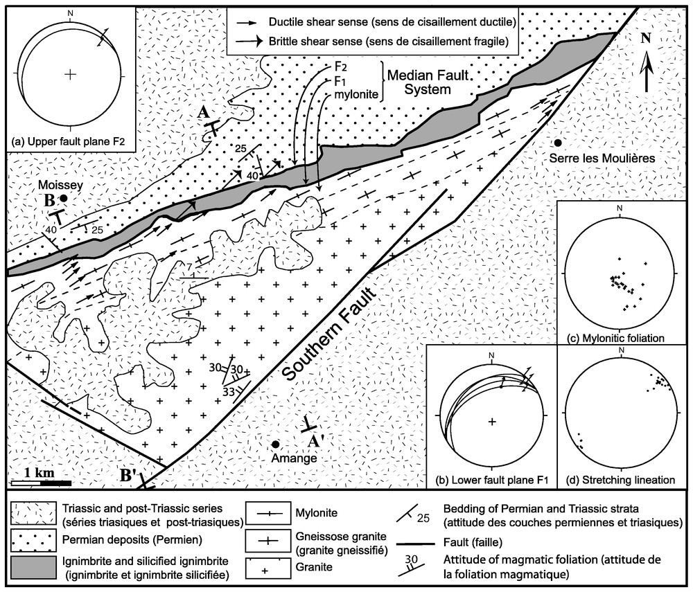
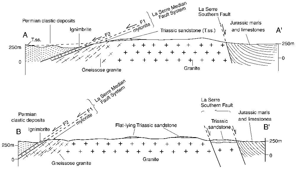
Structural sketch map (modified after [6]) of the Palaeozoic units of the La Serre horst and relevant cross-sections (A–A′: Moissey quarry; B–B′: Moissey gorges). Inset (a): Upper fault plane F2 at Moissey quarry. The great circle is the mean fault plane; the dot flanked with arrows is the mean striation; the double arrow symbolizes the observed right-lateral motion. Lower hemisphere equal-area projections. Inset (b): lower fault plane F1 at Moissey quarry: four measurements show gentle undulations of the fault plane; the single arrow stands for a normal motion (striation rake >45°). Inset (c): poles to mylonitic foliation (25 measurements). Inset (d): projections of stretching lineation (22 measurements).
Schéma structural des unités paléozoı̈ques du horst de la Serre (modifié d'après [6]) et coupes correspondantes (A–A′ : carrière de Moissey ; B–B′ : gorges de Moissey). Encarts : coaxialité entre structures fragiles (stries précoces) et ductiles (linéations d'allongement) associées à la zone faillée médiane de la Serre. Encart (a) : attitude moyenne du plan de faille supérieur F2 exposé à la carrière de Moissey (projection iso-aire en hémisphère inférieur). Le point flanqué de flèches est une moyenne des stries portées par le plan, avec le sens de cisaillement observé (dextre, symbolisé par une flèche double). Encart (b) : quatre mesures montrant les ondulations du plan de faille inférieur F1 à la carrière de Moissey. La flèche simple indique un sens de cisaillement normal le long d'une strie à pitch >45°. Encart (c) : pôles de la schistosité mylonitique. Encart (d) : projections de la linéation mylonitique (22 mesures).
Le socle hercynien est constitué d'un granite monzonitique à deux micas [17] daté à 362±12 Ma par la méthode U/Pb [18]. Les minéraux primaires sont quartz, feldspath potassique, plagioclase, muscovite et biotite. Du sud vers le nord, en se rapprochant de la zone faillée médiane, le granite à foliation magmatique planaire faiblement pentée vers le nord-ouest passe à un granite gneissique, puis à une mylonite, caractérisée par une fabrique planaire régulière et une linéation d'étirement minéral.
Un niveau d'ignimbrite (encore appelée eurite [4,5,22]), d'âge inconnu, repose sur la mylonite par l'intermédiaire d'une faille F1. Son épaisseur est comprise entre 10 et 30 m. Des grès, conglomérats et siltites datés de l'Autunien supérieur–Saxonien [5] recouvrent, par l'intermédiaire d'une faille F2, le niveau d'ignimbrite. Les conglomérats basaux remanient des fragments de granite, gneiss, mylonite et ignimbrite. Des grès du Trias inférieur, subhorizontaux, recouvrent en discordance le socle granitique et le Permien. Ils ne semblent pas décalés par les failles F1 ou F2 (Fig. 2).
3 Géométrie et structure de la zone faillée médiane
Dans la bordure gneissifiée, les minéraux hérités sont le quartz, le feldspath potassique, le plagioclase, la muscovite et la biotite. On y reconnaı̂t quelques rares cristaux de grenat et de sillimanite fibreuse relique, non observés dans le granite. Les minéraux néoformés sont le quartz, la biotite, et le mica blanc. La déformation fragile du feldspath ou du grenat et la stabilité de la biotite et du mica blanc montrent que l'orthogneissification s'est déroulée entre 500 et 300 °C.
La zone faillée médiane est orientée suivant N070°E et pend de 15°–30° vers le nord. Elle comprend des structures liées à des déformations ductiles et fragiles. De la base au sommet (Figs. 2 et 3), on distingue (a) la bordure gneissifiée du granite, épaisse de 100 à 200 m, (b) la zone mylonitique, épaisse de 100 m, (c) le plan de faille inférieur F1 séparant la mylonite de l'ignimbrite sus-jacente et (d) le plan de faille supérieur F2 séparant l'ignimbrite des dépôts permiens sus-jacents.
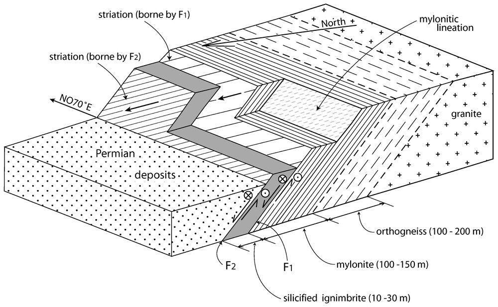
Schematic diagram summarizing the structure and pre-Triassic kinematics of the La Serre median fault zone (approximate scale).
Bloc-diagramme schématique résumant la structure et la cinématique anté-triasique de la zone faillée médiane de la Serre (échelle approximative).
Le granite gneissique passe progressivement à une mylonite à schistosité d'attitude moyenne (N070°E, 25°N). La foliation porte une linéation orientée N045°E (Fig. 2). Microscopiquement, le grenat et les feldspaths sont déformés de manière fragile et sont moulés par la foliation mylonitique. Le quartz, la biotite et la muscovite sont déformés de manière ductile. La déformation s'est donc déroulée autour de 300 °C.
Dans la carrière de Moissey, le contact mylonite–ignimbrite se fait à la faveur d'un plan de faille (plan inférieur F1) orienté N060°E, pendant de 20–30° vers le nord, et portant deux familles de stries : une famille précoce N045E° (Fig. 2), et une famille tardive N120°E à N130°E. Le contact ignimbrite–dépôts permiens se fait par l'intermédiaire d'un plan de faille (plan supérieur F2) orienté N070°E, pendant de 19±3° vers le nord (Fig. 2a), et portant deux familles de stries : une famille précoce N045E° (Fig. 2a), et une famille tardive N160°E.
4 Âge et cinématique de la zone faillée médiane
Les grès du Trias inférieur affleurant de part et d'autre de la zone faillée médiane ne sont pas décalés (Fig. 2). Ils scellent donc l'essentiel de l'activité de la faille. Les sections d'échantillons de gneiss et de mylonites perpendiculaires à la schistosité et parallèles à la linéation et les lames minces correspondantes montrent de nombreux critères de déformation non coaxiale, qui attestent un cisaillement dirigé vers le nord-est. Compte tenu de l'actuelle attitude des structures planaires du granite gneissique ou de la mylonite, ce sens de cisaillement correspond à une cinématique combinant un jeu normal et un jeu dextre.
Sur les deux plans de faille inférieur F1 et supérieur F2, le sens de cisaillement associé aux stries précoces N045°E est dextre-normal. Sur le plan de faille supérieur, le sens de cisaillement associé aux stries tardives N160°E est inverse et pourrait correspondre au raccourcissement NW–SE d'âge Mio-Pliocène [1,2,12].
5 Discussion et conclusion
Dans sa géométrie actuelle, la zone faillée médiane apparaı̂t comme une faille normale dextre à faible pendage (20–30°). Cette cinématique anté-triasique n'est valable que si (1) la faille n'est pas une faille inverse à fort pendage basculée tardivement, ou si (2), compte tenu du faible pendage actuellement observé, la zone faillée médiane n'est pas un segment à pendage nord d'un chevauchement onduleux à pendage général vers le sud. Ces deux possibilités, qui impliqueraient que la zone médiane soit originellement une faille inverse, sont écartées pour la raison suivante : la déformation la plus ancienne affectant les dépôts permiens consiste en des failles normales d'échelle métrique indiquant une extension N005°E à N030°E, voisine de l'extension N045°E indiquée par les stries précoces sur les plans supérieur et inférieur. Les déformations autres qu'extensionnelles observées consistent en des décrochements conjugués et sont postérieures aux failles normales.
Le parallélisme apparent entre la foliation magmatique du granite et la foliation du granite gneissique ou de la mylonite suggère que le cisaillement le long de la zone faillée médiane a commencé pendant la cristallisation du granite et s'est poursuivi au cours du refroidissement jusqu'à des conditions superficielles. Dans ce cas (extension tardi-orogénique), la déformation aurait un âge voisin ou légèrement plus jeune que 362 Ma, âge présumé de cristallisation du granite [18]. Cet âge est nettement plus ancien que les âges des extensions tardi-orogéniques dans les Vosges ou le Massif central (305–275 Ma, [8,9,13,21]). Une nouvelle datation du granite ainsi que de la déformation ductile (granite gneissique et mylonite) montrera si l'extension est tardi- ou post-orogénique.
Si la faille méridionale de la Serre semble se raccorder côté Massif central à la faille limitant le bassin de Blanzy [23] et côté Vosges à la faille de Retournemer–Sainte-Marie-aux-Mines [1,7], l'extension de la zone faillée médiane reste inconnue vers l'est. Vers l'ouest, elle pourrait se raccorder à la faille d'Autun, qui présente des caractéristiques géométriques et pétrographiques similaires [20].
1 Introduction
Like other mountain ranges such as the Alps or the Himalayas, the Variscan orogen underwent a crustal-scale extension following the Devonian to Early Carboniferous collision between the Gondwana and Laurussia continental blocks [8,11,13,14,16]. In the French Massif Central, the late- to post-orogenic extension was achieved through two diachronous but successive stages [9,10]. An early NW–SE extensional stage took place across the whole Massif Central in the Namurian–Westphalian (330–300 Ma) and was coeval with the emplacement of granitoids. A late NE–SW extensional stage occurred in Late Carboniferous-Early Permian times (305–275 Ma) and was responsible for brittle faulting, formation of intramontane coal basins, and ductile normal faulting at the margins of granite-migmatite domes. Crustal-scale extension also affected the Vosges–Black Forest Hercynian basement between the Middle Carboniferous and the Early Permian [8,19,21]. Granite emplacement between 335 and 315 Ma is the consequence of an early extensional stage that is roughly coeval with the early extension reported from the Massif Central, whereas formation of ENE elongated basins, rhyolitic volcanism and deposition of clastic sedimentary rocks during Late Carboniferous to Early Permian times appear to be contemporaneous with the second extensional stage in the Massif Central.
Despite its small size, the La Serre horst, located halfway between the Massif Central and the Vosges–Black Forest area, allows an examination of the pre-Mesozoic basement of the foreland of the Jura fold-thrust belt (Fig. 1). More precisely, it offers the possibility to study the La Serre median fault zone, a major structure likely pertaining to the NE–SW Late Carboniferous–Early Permian extension. We show that the shear along this ENE–WSW fault occurred in ductile (greenschist facies and possibly amphibolite facies) through brittle conditions, and combined the same normal and dextral displacement during the ductile stages as well as during the brittle stage.
2 Geological outline of the La Serre horst
In the La Serre horst, Palaeozoic rocks are exposed at the surface. Such an uplift results from normal faulting related to Oligocene crustal stretching and rifting in the Alpine foreland [2,3,12].
2.1 Major faults
The southeastern limit of the horst is the La Serre southern fault [6], a 10-km long fault striking N045°E and dipping 70° or more southeastwards (Fig. 2). The southwestern limit of the horst is a N150°E fault that abuts against the N045°E fault described above. The northwestern limit of the horst consists of a series of NE–SW normal faults dipping to the northwest and displacing the Mesozoic cover of the horst ([6]; not depicted in Fig. 2). Below widespread Plio-Quaternary deposits, Oligocene conglomerates of the Bresse graben locally crop out to the northwest of the fault zone. In addition to boundary faults, the La Serre horst is obliquely crossed by the La Serre median fault zone, which separates a Variscan granite from Permian deposits (Fig. 2).
2.2 The Variscan basement
The oldest exposed rock is a two-mica monzonitic granite [17] dated at 362±12 Ma by the U/Pb method [18]. In the southernmost part of the area occupied by the granite, feldspar crystals define a magmatic foliation striking NE–SW to NNE–SSW and dipping about 30°NW. Going northwestwards, that is closer to the median fault zone, the granite progressively turns to a gneissose granite. A few hundred meters from the fault, the gneiss progressively turns to a mylonite characterized by a regular planar fabric and a marked mineral and stretching lineation.
2.3 The volcanic cover
An ignimbrite layer of unknown age is in fault contact (lower fault plane F1) with the mylonitic margin of the granite. Its thickness is comprised between 10 and 30 m. The ignimbrite, also called ‘eurite’ [4,5,22], has a brecciated aspect and shows, from bottom to top, a decrease of the clast size (from the meter scale down to the millimetre scale), a decrease of the clast-to-matrix ratio (from >0.9 to <0.1), a decrease of the abundance of mylonite-derived clasts, and a correlative increase of monomineralic undeformed quartz or feldspar clasts, some of which are clearly of magmatic origin (rounded or embayed plagioclase crystals). Despite intense fracturing, a sedimentary bedding can be recognized, testifying to a deposition under water. Due to a pervasive secondary silicification, the original texture of the ignimbrite cannot be easily observed, but devitrified glass is locally preserved in the upper parts of the ignimbrite layer [22].
2.4 The sedimentary cover
Permian fluviatile to deltaic deposits structurally overlie the ignimbrite layer and consist of reddish, poorly stratified and ill-sorted conglomerates, sandstones and siltstones of Upper Autunian to Saxonian age [5]. Immediately above the contact with the ignimbrite (upper fault plane F2), the conglomerates contain abundant pebbles of granite, gneiss, mylonite and ignimbrite of heterogeneous size and roundness. Since it is reworked in the Permian strata, the ignimbrite was emplaced before their deposition, that is before the Autunian (295–275 Ma). Flat-lying Lower Triassic (Buntsandstein) coarse arkosic sandstones unconformably rest on the granite and the Permian strata, with no detectable offset from one side of the median fault zone to the other (Fig. 2).
3 Geometry and internal structure of the La Serre median fault zone
The La Serre median fault zone strikes N070°E and dips 15°–30° northwards. It is a shear zone composed of ductilely deformed as well as brittlely deformed rocks. From bottom (granite) to top (Permian deposits), it includes (1) the 100 to 200-m-thick gneissose granite, (2) the 100-m-thick mylonite zone, (3) a lower fault plane F1 separating the mylonite zone from the overlying ignimbrite, (4) an upper fault plane F2 separating the ignimbrite from the overlying Permian strata (Figs. 2 and 3).
3.1 The gneissose granite
It consists of a fine-grained gneiss whose foliation is defined by the regular arrangement of feldspar porphyroclasts. In addition to the primary minerals inherited from the granite (quartz, K-feldspar, plagioclase, biotite, muscovite), the gneiss also contains rare garnet and rare fibrous sillimanite, the latter being surrounded by white mica. Secondary minerals found in pressure shadows flanking feldspar porphyroclasts or along shear bands consist of quartz, biotite and white mica (muscovite or phengite). The brittle deformation of feldspar or garnet, the ductile deformation of inherited micas and the stability of neoformed biotite and white mica indicate that the deformation took place between 500 and 300 °C.
3.2 The mylonite
The gneissose granite progressively grades upward into a mylonite macroscopically characterized by stretched feldspar porphyroclasts flanked by quartz-mica tails. The mylonitic foliation (Fig. 2c) is more pronounced than that of the gneissose granite, and is underlined by secondary white mica. The mylonitic lineation is clearly defined by elongated quartz rods, broken and stretched feldspar clasts, and white micas. The mean attitude of the foliation is (N070°E, 25°N) and the mean trend of the lineation is N045°E (Fig. 2d).
Deformation of feldspar and minor garnet is brittle whereas that of quartz, biotite and primary muscovite is ductile: quartz shows mosaic textures and strongly undulose extinction, and biotite or primary muscovite are bent and form mica fish. The coexistence of ductile and brittle microstructures and the stability of white mica and chlorite show that the deformation took place around 300 °C.
3.3 The lower fault plane F1
In the Moissey quarry (Fig. 3), the mylonite is separated from the above-lying ignimbrite by a fault plane F1 striking N060°E, dipping 20°–30° northwards, and bearing two families of striations: early-stage striations trending N45E° (Fig. 2b), and late-stage striations trending N120°E to N130°E. Immediately below the fault plane, the mylonite is strongly brecciated. Secondary quartz cements the fragments and fills the fractures.
3.4 The upper fault plane F2
The upper fault plane F2 is well exposed in the Moissey quarry, where a polished slickenside surface separates the silicified ignimbrite from non-silicified Permian deposits (Figs. 2 and 3). The slickenside surface strikes N070°E and dips about 20° northwards (Fig. 2a). Like the lower fault zone, the surface bears two families of striations: well-marked N045°E striations (Fig. 2a), and poorly marked N160°E striations overprinted on the N45° ones.
4 Age and kinematics of the La Serre median fault zone
4.1 Minimum age of the La Serre median fault zone
Lower Triassic deposits are found on both sides of the La Serre median fault zone, that is on the granite, gneissose granite and mylonites, and on the Permian strata. Though they do not directly seal the median fault zone, a side-to-side comparison shows that the Triassic deposits are not offset by the fault (Fig. 2, section A–A′). This indicates that no significant displacement occurred along the median fault zone after the deposition of Lower Triassic sandstones (circa 240 Ma).
4.2 Sense of shear deduced from the ductile structures
If cut perpendicular to the foliation and parallel to the lineation, gneissose granite or mylonite hand-sample sections and thin sections show abundant non-coaxial shear structures. All indicators testify to a top-NE shear which, given the present strike and dip of the gneissic or mylonitic foliation, corresponds to a combined normal and right-lateral shear.
4.3 Sense of slip deduced from the brittle structures
The slickenside surfaces of the lower and upper fault planes bear well-expressed N045°E striations generated by ploughing indurated elements. For both fault planes, the morphological irregularities associated with the N045°E striations indicate a sense of slip combining normal and dextral slip. On the upper fault plane F2, the slip along the N160°E striations is a reverse one, and is clearly posterior to the N045°E one. It could correspond to the Mio-Pliocene NW–SE shortening of the Alpine foreland (formation of the Jura fold-thrust belt). The sense of slip associated with the N120°E–N130°E striations borne by the lower fault plane F1 could not be ascertained on the present exposures.
5 Discussion
5.1 Nature of the La Serre median fault zone
If the present geometry of the La Serre median fault zone is the original one, the fault appears as a low-angle normal-dextral fault (possibility 1) but, given the low dip angle (the upper fault plane F2 dips less than 20°), the median fault zone could also represent the foreland-dipping segment of an undulating NE-verging thrust fault (possibility 2). This leaves open the possibility that, depending on the sense and amount of rotation, the median fault zone could be in fact either a tilted normal fault (possibility 3) or a tilted thrust fault (possibility 4). The following observation weakens possibilities 2 and 4. Mesoscale faults in the hanging-wall Permian deposits are of two types: early-stage normal faults and late-stage strike-slip faults. Determination of the stress tensors pertaining to the normal faults indicates a N005°E to N030°E extension, likely contemporaneous with the N045°E extension along the upper and lower fault planes. Determination of the stress tensors associated with the strike-slip faults gives a N145°E to N170°E shortening, which is reminiscent of the reverse slip along N160°E observed on the upper fault plane. These observations show that the earliest deformation recorded in the Permian deposits is an extension, thus weakening possibilities 2 and 4. Possibility 3 is a peculiar case of possibility 1 and need not be discussed.
5.2 Late-orogenic versus post-orogenic extension
Apparent parallelism between the magmatic foliation of the granite and the foliation of the gneissose granite and mylonite suggests that the shear along the median fault zone started during the crystallisation of the granite and was continuous through cooling until reaching brittle conditions. If this Late-Orogenic extension hypothesis is confirmed, it follows that the deformation has the same age or is slightly younger than the 362 Ma, presumed age of crystallization of the granite [18]. This age is much older than the 305–275-Ma ages of Late-Orogenic extensions in the Vosges or the Massif Central [8,9,13,21]. Either the Late-Orogenic extension started earlier in the La Serre area than in the surrounding areas, or the 362-Ma age should be re-examined. Furthermore, dating of the deformation of the gneissose granite and the mylonite should help deciphering between a Late-Orogenic or a Post-Orogenic extension. In this last case, the deformation should clearly postdate the crystallisation of the granite.
5.3 Regional correlations
The Bouguer anomaly map of the Bresse graben and surroundings [23] allows us to follow basement faults beneath the Mesozoic and Cainozoic sedimentary cover of the Bresse graben and Jura foreland. It suggests that the La Serre southern fault extends southwestwards to the southern border fault of the Carboniferous–Permian Blanzy basin. Northeastwards, fault mapping and satellite image analysis suggest that the southern fault could link with the Retournemer–Sainte-Marie-aux-Mines fault crossing the Vosges basement [1,7]. Since it is truncated by the La Serre southern fault, the eastward extension of the median fault zone is unknown. Conversely, its westward extension in the Morvan block to the west of the Bresse graben (Fig. 1) could be the Autun fault, which limits the Autun Permian half-graben to the south. The Autun fault displays several similarities with the La Serre median fault zone: (1) it separates Permian deposits to the hanging-wall from a gneissose or mylonitic granite to the footwall; (2) its pre-Mesozoic kinematics combines normal and dextral motions [20].
6 Conclusion
Despite its tiny size, the Palaeozoic La Serre horst allows an analysis of the geometry and kinematics of the pre-Triassic La Serre median fault zone separating a Variscan granite from a Permian or older ignimbrite and from Permian deposits. This fault is characterized by a low-dip angle (20–30°) and displays ductile and brittle shear structures. Both types of structures indicate a top-NE shear sense which, given the present-day geometry of the fault, corresponds to a combined normal-dextral motion. A similar motion has been reported from several NE–SW to ENE–WSW faults bounding Permo-Carboniferous grabens in the eastern Massif Central [13,15,20,24]. This motion reflects the general NE–SW crustal stretching having affected the Variscan orogen at the end of Carboniferous through Middle Permian times [9,10]. Re-examination of the age of the crystallization of the granite and new dating of the ductile deformation (gneissose granite and mylonite) should help deciding between late-orogenic and post-orogenic extension.
Acknowledgements
Study supported by the Région Franche-Comté. Fruitful discussions with French, Swiss and German colleagues were possible during EUCOR-URGENT workshops supported by the European Science Foundation. Comments by MM. J. Angelier, M. Faure, D. Marquer and M. Rossy helped improve the manuscript.