

1 Introduction: the ARCHAEOMEDES Project
The case study presented in this paper is part of the research undertaken between 1992 and 2000 by a multi-national, multi-disciplinary team on (past and present) land degradation in the Mediterranean Basin [24]. Its aim was to better understand present-day land degradation in the area by investigating the long-term dynamics of this process from a ‘complex adaptive systems’ perspective [13,14,25] that integrates the study of the natural and the socio-cultural and economic dynamics in a single approach2 [20,21].
A major raison d'être for the present study lies in the fact that most of the research on environmental degradation is concerned with very short time-spans, of up to a century at most. As a result, the approach is inadequate in a number of different ways:
- • degradation is often a long-term process, with slow, cumulative phases, but also with sudden accelerations or decelerations. The typical time-scales of the natural dynamics involved range from thousands of years (tectonics) to five or six hours (weather patterns). The social dynamics operate on the scale of millennia, centuries and decades. Measurement and monitoring over a few years, or even a few decades, is thus insufficient;
- • most processes involve multiple time-scales, so that the chances that the same conjunction of dynamics occurs twice or even more frequently are very slim indeed. Studying the present amounts to studying only one particular instance of degradation, while studying the long term allows one to observe many more in the same geographical context, so that one may begin to model the dynamics involved in more general terms [21];
- • as degradation processes are spatially constrained by other elements of landscape formation, one needs to understand the landscape as a whole if one is to credibly understand the spatial occurrence of degradation. The spatial organization of any landscape is the cumulative result of a series of different kinds of dynamics imposed on it at different times. A landscape is thus like a multiple exposure photograph, or in historical terms, like a palimpsest which shows remains of many different kinds of dynamics. Hence, landscapes are only explicable by investigating the very long term;
- • investigating degradation in isolation, without placing it in the context of wider environmental and social dynamics, is like attempting to understand the normal functioning of a human body entirely by examining the sick. We need to place the study of degradation in the context of other phases of landscape formation, such as soil formation, expansion of the vegetation, and human behavior that does not result in degradation. Doing that on the basis of data concerning the present alone is impossible;
- • finally, our investigation should not only be concerned with change, but also with the change of change – the way in which the dynamics themselves (and not only their results) have changed over time. The rise of urbanism is only one of the manifestations of a balance in which human-induced processes operating on shorter time-scales have steadily been gaining ground over the (slower) processes occurring in nature. That shift has had profound consequences, which we must understand if we are ever to evaluate what happened at any specific point in time.
2 Identifying the component processes of environmental change
In the second half of the twentieth century, scholars in many countries and disciplines have ‘negotiated’ a communis opinio that there is a ‘crisis’ in the second and third centuries ad. But if one looks more closely at the arguments, they are different in each case, describing different phenomena and attributing these to different causes. In a review of the literature, Provost [22] cites as causes fluctuations in climate, the exhaustion of soils, the plague, the end of the Pax Romana as evidenced by renewed Germanic migrations, the beginnings of Anglo-Saxon piracy, and civil wars in Gaul. Others have cited yet different causes, including massive lead poisoning. By adopting a ‘complex adaptive systems’ perspective, and looking at the interaction between geology, climate, hydrology, soils, vegetation, fauna, human settlement pattern, economic and social dynamics, we have tried to move away from any form of determinism in explaining this “crisis”, and thus to gain a deeper insight into it.3
In practice, this implies identifying the main components of the complex dynamic that is reflected in the evolution of the landscape. To achieve that aim, we have focused on the differences in spatial and temporal scale at which the component processes manifest themselves. This has enabled us to identify the respective roles of climate, relief, soils, human land use and human settlement pattern.
2.1 Climate and its impact
The Rhone Valley (Fig. 1) stretches north–south, and therefore forms a natural transect across the transition zone between the circum–Mediterranean climate and more temperate ones. A complicating, and on occasion equilibrating, influence is exerted by the Alpine climate zone to the east of the valley, which oscillates with a different rhythm.
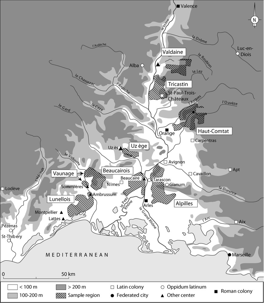
Map of the Middle and Lower Rhone Valley, showing the sample areas referred to in this paper.
Carte de la moyenne et basse vallée du Rhône, et des secteurs échantillonnés.
Our first concern has been to reconstruct the evolution of the paleo-climate of the region. For that purpose, we have analyzed around a hundred columns of soil taken from around 40 km of trenches dug as part of various civil engineering projects in the Valdaine (a region on the left bank of the Rhone, south of Lyon). The full vertical profile of the soil was impregnated with resin, and large thin-sections cut from these samples. By submitting these thin-sections to a variety of analytical techniques, it was possible to identify the materials involved, as well as the conditions under which the different layers of material had been deposited, eroded or transformed into soils [12]. Other techniques allowed us to identify different remains of the vegetation (pollen, charcoal), micro-fauna (land-snails, insects) and other indicators of the evolution of the climatic conditions and the natural environment.
The evidence seems to point to a complex relationship between changes in climate, variations in the vegetation, and human impact on the landscape, in which time delays and the technical means of human populations play an important role. Our analyses provided strong indications for a number of major phases of degradation and erosion in the Rhone Valley during the Holocene (Fig. 2).

Graph showing phases of Holocene degradation and pedogenesis in the Valdaine [1,2,5,6,8,17,19].
Graphe résumant les phases de dégradation et de pédogenèse dans la Valdaine durant l'Holocène [1,2,5,6,8,17,19].
For the earlier part of the period, it seems that when agro-pastoral pressure, degradation of the weather and degradation of the vegetation cover all occur simultaneously, the reaction in the sedimentary record is almost immediate (at the scale of the Holocene). But when they are out of phase, delays appear and periods of heavy human pressure on the environment may be less visible than one would expect, or become visible only much later.
From the Middle Neolithic onwards, for example, human action gains in importance for the state of the vegetation, and the landscape itself is much more subject to even minor climatic oscillations, notably in humidity and in seasonal contrast. But because these dynamics are out of phase, they result in several millennia in which there are important delays between phases of agro-pastoral pressure on the environment (as registered in the paleo-botanical record) and the erosion that is the response of the physical environment in the appropriate areas.
Towards the end of the period (in the last millennium or two) on the other hand, the different component processes are so tightly interconnected that the slightest oscillation in one or the other immediately has important consequences for the system as a whole.
Three of the observed erosion episodes are particularly extensive both in space and in time. The first occurred at the end of the Neolithic (ca. 4000 bc), after the first wave of human expansion, which is driven by the introduction of agriculture. The second, which is attributable to a combination of human impact and climate change, followed at the end of the Bronze Age (ca. 2000 bc). The third, in the Roman period, occurs subsequent to a complete change in the structure of agriculture that was initiated around the middle of the first millennium bc with the introduction of new crops and new agricultural techniques.
Comparing (cf. Fig. 3) this information with the global evolution of climate during the Holocene, one immediately remarks that the Bronze Age and Roman erosive phases identified in the regional curve are missing in the global climate curves. We interpret their absence in the global climate curves as indicating that we have to do with regional phases of deterioration of the climate. Although the signal for a regional Bronze Age erosive phase is rather weak and difficult to interpret, the signal for the Roman period is very clear. The deterioration in Roman times seems principally due to human activity, and in particular the very widespread and rapid transformation of the countryside from predominantly forest to intensively cultivated agricultural land [4].
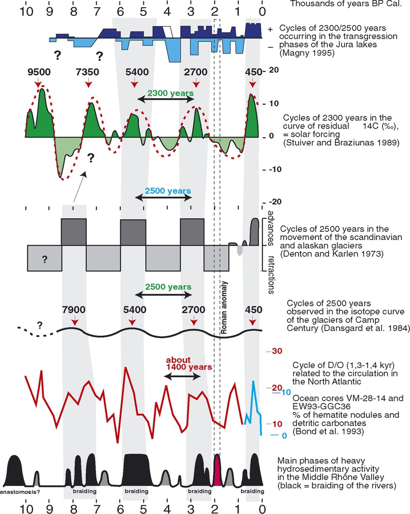
Graph showing global and regional phases of degradation and pedogenesis. Note that the Bronze Age and Roman phases of degradation that appear in the regional curve are absent in the global curves [7,10,11,18,23].
Graphe indiquant les phases globales et régionales de dégradation et de pédogenèse. Les instances de dégradation à l'Âge du Bronze et à l'époque romaine apparaissent dans la courbe régionale, mais pas dans la courbe globale [7,10,11,18,23].
2.2 The settlement pattern
Once the impact of climate dynamics on environmental change had been identified, the next task was to isolate the principal interactions occurring between relief, soils and water on the one hand, and the societal dynamics on the other. Assuming that degradation is the result of the interaction between a natural dynamic and a social one, it would seem to be closely, but differentially, related to the spatial pattern of human activities. Our first consideration was therefore to reconstruct the dynamics of the settlement pattern.
Archaeological survey in the area has shown that major erosion in the Neolithic and Bronze Age has transformed the landscape to such an extent that many of the settlements from pre-Roman periods are now buried under thick colluvial or alluvial deposits, or were destroyed by landslides. As a whole, therefore, the pre-Roman settlement patterns of the region cannot be reconstructed with sufficient precision to allow us to study the dynamics responsible for them. But the same surveys show that the landscape has changed very little since Roman times. We therefore limited our reconstruction of the settlement dynamics and their interaction with the landscape to the Roman and later periods. This had the added advantage that we could focus on the case study in which the anthropogenic dynamics were presumably the most clearly evident.
For the eight sample areas in the middle and lower Rhone basin (Fig. 1), and for the period from 500 bc to 600 ad,4 we thus proceeded to determine the location, period of occupation, size and function of the (more than 900) settlements found.
At the regional level, this allowed us to identify the major phases of Roman settlement creation and abandonment of the area in time and space, while at the local level it pinpointed the areas of direct intensive interaction between human activity and the landscape. The principal wave of Roman colonization spread land inward from the area around Marseille (Fig. 4), between about 100 bc and ad 150 (Fig. 5). Then, the foundation of new settlements abruptly ceased, and over the next two centuries, the number of settlements in use declined. Some of the deserted areas were however re-settled in the 4th, 5th and 6th centuries ad.
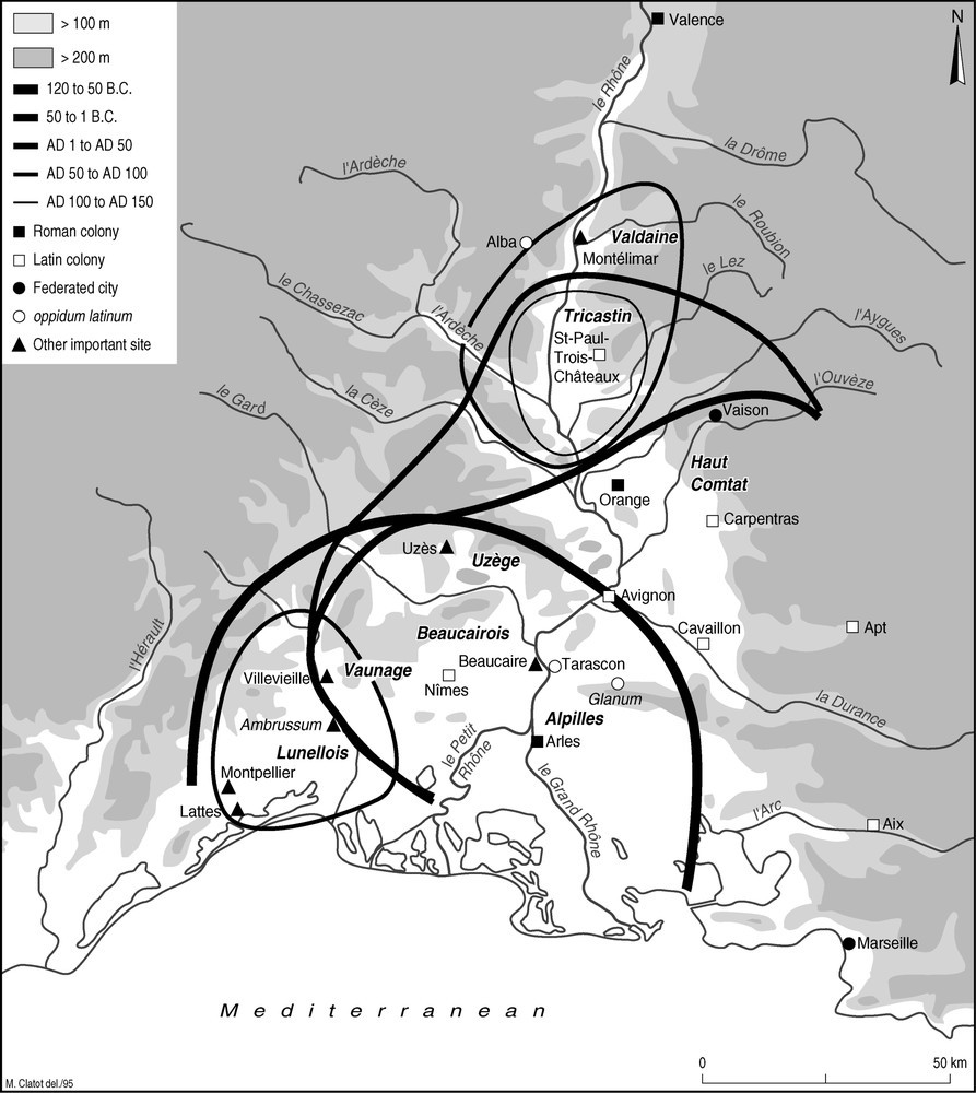
Map of the Middle and Lower Rhone Valley, showing the different phases of the Roman colonization of the area.
Carte de la moyenne et basse vallée du Rhône, indiquant les différentes étapes de la colonisation romaine dans la région.

Graphs indicating (A) the number of settlement foundations per half century, and (B) the number of settlements in active use, for the period 50 bc–ad 600. Note the abrupt cessation of new settlement in the 2nd century ad.
Graphes indiquant (A) le nombre de nouvelles implantations par demi-siècle et (B) le nombre des implantations actives, pour la période 50 av. J.-C.–600 ap. J.-C. Remarquez la cessation abrupte de nouvelles implantations au IIe siècle ap. J.-C.
At the local level, we were able to quantify the relative impact of Roman colonization on the density of settlements in the different sampling areas, as well as to study the spatial configuration of Roman settlements throughout the period. This information was particularly important when projected against a reconstruction of the natural dynamics of the landscape.
2.3 The relief and the soils and their relation to the settlement pattern
To understand those natural dynamics, the next step was the reconstruction of the evolution of the relief in the area. Normally, such reconstruction demands highly intensive and costly geophysical survey, and a high density of excavations, if it is to yield trustworthy results. This process takes many years, and the cost is well beyond the means of a scientific project such as ours. But an extensive archaeological survey in the eight sample areas in the 1980's demonstrated clearly that there have been no phases of major landscape change since the Roman period. We have therefore used a digital elevation model of the present-day landscape in the sample areas as our basis for modeling the Roman relief and its derivatives, slope, orientation, erodibility, solar radiation, and exposure to the prevailing winds. Projecting the location of the settlements onto this model of the landscape provided us with data concerning a range of aspects of their ‘immediate (natural) environment’ and their (natural) ‘surroundings’.5
However important, the relief-related aspects are only part of what constituted the natural environment of the Roman settlements. The other relevant components were the hydrology and the soil. The hydrology was approximated on the basis of modern maps (for major sources of open water) and remote-sensing images (from which we took measures of the relative humidity of the landscape).6 To map the soils, we used either modern soil maps or, for areas where these did not exist, derivatives from the most detailed geological maps. In as far as possible, both were reclassified according to the Roman perception of soils found in Columella and Pliny the Elder.7
Next, we statistically confronted the settlements with their environment and surroundings. Localizing a settlement somewhere is a choice – and one that must have been made as a result of a set of observations guided by conceptions and value judgments about various aspects of the environment. Hence, a multivariate treatment8 of the relationship between settlements and their environments allowed us to answer two important questions:
- • Is the environment important in determining the choice of location of individual settlements when people move into un-exploited areas? (And if so, which aspects of the environment are relevant?).
- • Is the environment important in determining which settlements are deserted? (And if so, which aspects of the environment are relevant?).
The answers to these questions differ in a very interesting way. The initial colonists (who could choose their location freely) favored sheltered locations on low, gentle slopes oriented towards the southeast, south or southwest, and easy to plough, well-drained, soils. They located their settlements at considerable distance from each other. Later settlers, however, moved either higher up the slopes (which were therefore often steeper), and/or settled in locations that captured less sun. Often, their settlements are found in between the earlier (and by now larger) settlements, in less favorable locations. Yet later settlers tackled the heavy, poorly drained soils of the plains such as the Tricastin or the Lunellois.
Whereas the perception of the landscape is indeed important in choosing a place to settle, the environment is much less important in determining which settlements are deserted between the end of the 2nd and the middle of the 3rd century ad. In all eight sampling areas, 80% of all the sites were abandoned within two centuries of their foundation, even though these sampling areas represent very different environments (Fig. 6). And when one looks closely at which settlements were deserted and which survived, the determining factors turn out to be the size of the settlement and its accessibility, rather than its environment. The surviving settlements are the larger ones, which are generally located on or near five or six roads, whereas the deserted settlements are smaller, and only accessible by one or two roads.

Graphs showing, for each of ten different kinds of natural environment (Rel 1-10), (A) the number of sites surviving after 1, 2, 3, 4, 5 or more centuries, and (B) the proportion of such sites among the total number of sites. Note that after some 200 years, in each environment, 80% of the new settlements have been abandoned.
Graphes indiquant, pour une dizaine d'environnements différents (Rel 1-10), (A) le nombre d'implantations qui survivent après 1, 2, 3, 4, 5 siècles ou plus, et (B) la proportion de sites que cela représente sur le total. Remarquez que, après 200 ans, 80% des implantations dans chaque secteur ont été abandonnées.
Hence, the ‘crisis’ of the 2nd and 3rd centuries does not seem to have been caused by environmental factors. The available data point to a rationalization of the settlement pattern, in which the smallest (and presumably economically weakest) settlements disappear. We must conclude that once the new settlement system had established itself in the area, and the individual settlements were linked into the wider economy, anthropogenic dynamics drove the coupled system.
2.4 The socio-economic dynamics behind colonization and settlement desertion
What, then, is the nature of these anthropogenic drivers? What causes the ‘boom’ and ‘bust’ of the rural economy? The answer seems unambiguous: the spread of mass-production. The Roman organization of the rural landscape intensifies a change that was initiated a few centuries earlier with the introduction of the Mediterranean three-crop agricultural system (based on wheat, olive and vine). In the Roman rural ‘regime’, areas that were thus far primarily used for cereal cultivation (i.e. the well-drained light soils in valleys, on foothills and on the lower slopes of mountains) were now to a considerable extent devoted to olive and vine. Our settlement data confirm this, in the sense that the mass of the new early Roman settlements found itself in these zones.
Once they had a grip on the area, the Romans invested heavily in the clearing, draining and irrigation of areas that had so far been marginal to the economic system. The use of heavy soils requiring drainage for the cultivation of cereals constituted in fact another corollary to the revolution which agriculture was undergoing.
It would seem that the investments required were only feasible if agro-pastoral activities had a high yield factor. Thus, many of the areas brought under cultivation by heavy investment were planted with cash crops. The first among these was the vine. The expansion of the rural wine industry is known from the written sources (the Roman agronomists mention new varieties, new techniques and new wines) as well as from our archaeological data. Several large wine making installations have been found, with storage capacities of up to 2800 hl of wine (!), and the production of ancient ‘wine bottles’ (amphorae made of pottery) became a truly massive affair [15,16]. We must stress that such wine production, therefore, is effectively a kind of agro-industry, comparable to some that we see in the same area in the 19th and 20th centuries.
But wine is not the only such speculative crop. We also have evidence for comparable agro-industrial exploitation of olive oil, notably many large oil-presses and the storage facilities that go with them. Lastly, the many written sources on commerce in foodstuffs make it very clear that wheat was as much a cash crop as wine and oil. Although they do not mention this part of Gaul specifically, there are many areas in the region that were eminently suitable for wheat cultivation, and the region's proximity to Rome makes it highly probable that at least part of that wheat was exported to the capital. This ‘agro-industrial’ exploitation of such crops tied the region firmly to the vagaries of the wider Mediterranean commodities market. They were important in the ‘boom’ of the first century, but also contributed to the relative ‘crisis’ that followed in the 2nd and 3rd centuries ad.
That ‘crisis’ seems to have been triggered by a mixture of economic and political events. Political stability came rapidly to an end when Commodus was assassinated on the last day of ad 192. The decades that followed witnessed one war after another, culminating in a half-century of unremitting crisis between ad 235 and ad 284. During that period, the Roman Empire nearly came to an end. There were both foreign and civil wars, which at times followed one upon another almost without interruption. Many provinces were devastated. The army and the bureaucracy grew in size, and taxes were increased.
During this period, the whole empire suffered from fiscal devaluation and inflation. The fortunes of the middle and lower Rhone area would have waxed and waned, but not necessarily in phase with those of the Empire as a whole. After ad 192, the area suffered considerable instability for roughly three decades. Then there were some decades of peace, during which some return to prosperity was possible within the constraints of overall economic deterioration. The presence of a frontier garrison meant high demand for products, with low shipping costs. A general decline in the circulation of coins (due to their lack of value) would have meant reduced prosperity, but perhaps without a great reduction in the intensity of land use. But after the middle of the 3rd century ad, economic and political degradation intensified until it was more or less halted by Diocletian (ad 284–305) and Constantine (ad 306–337).
The observed regional ‘crisis’ is part of this dynamic. The abandonment of many outlying, small settlements is part of a reorganization of the regional agricultural exploitation system, which falls back on its principal population centers and large rural estates, the so-called latifundia. That reorganization increased security and efficiency, but also led to an increase in the contract between rich and poor.
It is impossible to survey the exact causes and effects of this downturn at the level of the whole lower Rhone region. For that, we have to look at the individual sample areas. By way of example, we have done so for one of, them, the Tricastin.
3 A drain too far: the Tricastin
The Tricastin plain alongside the Rhone south of Valence has been chosen because of its richness of both written and archaeological data. Quite exceptionally, for example, we possess fragments of a Roman map of the area. Engraved on marble around 77 ad and exhibited in the town of Orange at the time, it shows the Roman land register, a number of features such as the rivers, and the location of a number of the plots of 50 hectares (so-called centuriae) into which the land was divided. The status characterization ranges from whether the land is still land (or has been taken back by the river), to the territory in which it is located. It also includes statements as to the individual who rents the plot, and/or how much land rent he or she pays to the state. But we also have rich archaeological data for the region – in this case, a number of excavated settlements and other features of the Roman landscape, and the results of an archaeological surface survey. Together, they allow us to follow the history of the area's settlement pattern in the usual 50-year periods over about 600 years. Thirdly, scrutiny of topographic, geological and hydrological maps and air photographs enabled us to identify the Roman infrastructure on the ground, and to extend the cadastral land divisions to those areas for which we have no surviving fragments of the marble map. It also allowed us to identify a number of anomalies in that infrastructure, which pointed to the difficulties the Romans encountered in making the land suitable for exploitation.
Before the map was confronted with other evidence, a thorough internal critique reassessed its status in Roman land policy. It was established that the map embodied an attempt to assess the current state of a century-old development plan that aimed at draining and colonizing the whole plain. The internal critique also permitted us to roughly outline which parts of the land belonged to each of the three main authorities involved (the Emperor, the colony of Orange or the tribe of the Tricastini), and which lands had been assigned to army veterans for their (active) retirement.
Once this was done, we first tested the validity of the soil categorization scheme we used, by comparing the soil map with the land rent values mentioned on the Roman map (Fig. 7). The comparison shows that the land rent values are directly linked to the Roman perception of the suitability of the soils according to Columella and Pliny the Elder. It was also possible to see how the different large landowners cultivated different combinations of soils, and must therefore have had different exploitation strategies.
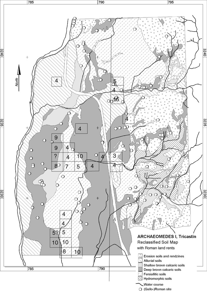
Map of the Tricastin showing the location of centuriae for which land rent values are known, projected on the soil map reclassified according to Columella and Pliny the Elder.
Carte du Tricastin indiquant l'emplacement des centuries dont nous connaissons la valeur locative, projetées sur la carte des sols reclassifiée d'après Columelle et Pline l'Ancien.
Next, confronting the archaeological data with the Roman map and the soil map (Fig. 8), it was possible to follow different phases in the colonization in this particular area. Colonization began around the beginning of the 1st century ad in the southern part of the Rhone plain (possibly because flooding still occurred regularly in the northern part). Around 50 ad, the northern part of the valley was also occupied. In the selection of settlement locations, the colonists stayed as close as possible to the infrastructure (roads, waterways and drainage), and chose the best available soils according to Columella's categories. Initially, in the Augustan period, 64% of sites in the flood plain are located along boundary roads between centuriae, and 70% at less than 2000 m from the river. This proportion diminishes as we move east, towards the older terraces (where the landscape is more varied and other factors thus affected the choice of location). But nevertheless, 48% of sites from this period are within 2000 m of the main north–south ‘highway’, the Via Agrippina.
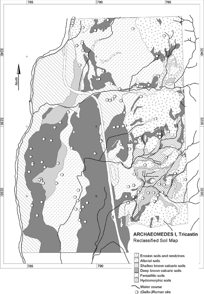
Map of the Tricastin combining archaeological settlement data with reclassified soil data.
Carte du Tricastin avec les données archéologiques et les données pédologiques reclassifiées selon Columelle et Pline l'Ancien.
In the middle of the 1st century ad, the infrastructure loses its strong influence on settlement choice somewhat – maybe because the best places have already been taken. Settlement develops on soils of type 1. At the beginning of the 2nd century ad, colonization was limited to the northern part of the plain; the fact that the landscape filled up with settlements played its own role, as it pushed the settlements further away from the infrastructure. Finally, in this period, the number of new foundations does for the first time equal that of the desertions.
For much of the 2nd century ad, desertions predominate. By monitoring the location and nature of these desertions, it was easy to prove that location played no important role and that the large majority of deserted sites consisted of either ancillary buildings to larger sites, or relatively isolated farms. The most important sites are not deserted, but often restructured. This comforts us in our conclusion that on the whole, the desertions are tied to a general phase of restructuring of agriculture, rather than some environmental ‘crisis’. But at the same time, on plateaus and slopes, most of the soils show signs of erosion dating from this period.
All through the third century, the process of abandonment continues, although from the fourth century onwards, other kinds of sites are being founded (in the caves of the Donzère, for example). The main survivors of this phase of desertion are the five largest villas in the area and the agglomerations, many of which come to form the nodes of the early medieval settlement system.
The central problem governing the Roman history of the Tricastin plain, and leading to land and settlement abandonment, seems to have been the management of water. By confronting the Roman map, the hydrological map and the air photographs, it was possible to identify a number of the key features of the drainage system as it was laid out around the beginning of our era (Fig. 9). One immediately remarks that the Roman system relies heavily on artificial drainage in either a southerly or a westerly direction, instead of the southwesterly direction of the natural drainage system. The network was conceived as a hierarchically organized system to regulate the water balance over the whole plain, collecting it in individual plots and bringing it down to the Rhone. Even the shape of the individual parcels of land is dependent on the hydrology. Naturally drained areas are divided into irregular, square to rectangular plots, while poorly drained ones are divided into long narrow strips by small drainage ditches. But equally important is that, due to the natural situation and to the scale at which the Romans conceived it, this drainage system was only effective because it linked a very large area.
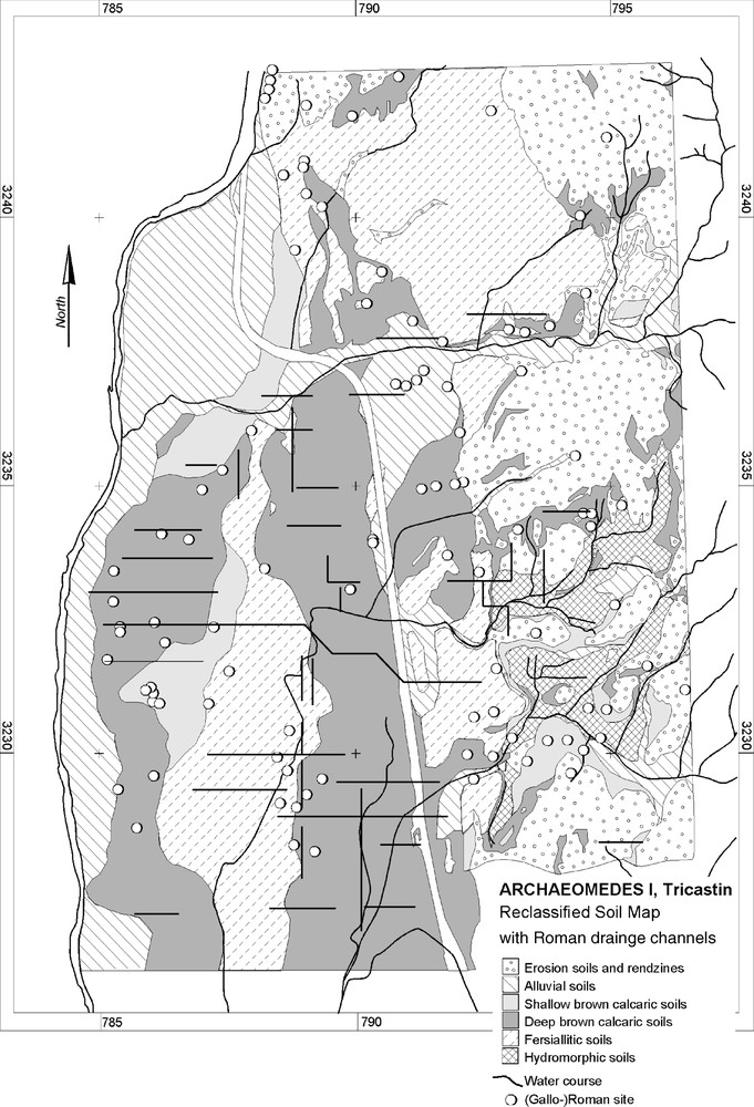
Reclassified soil map of the Tricastin with the natural rivers and the orthogonal Roman drainage system of the area.
Carte du Tricastin, avec les cours d'eau naturels et le système orthogonal de drainage romain.
Between the moment of the system's conception, in the last quarter of the first century bc, and the time when the colonization ran out of steam some 100 years later, a number of things had changed. To understand these, we have to take into account that the hydraulic regime of the Rhone itself is governed by Alpine climatic circumstances, and that it showed a marked increase in the volume of water transported between about 70 bc and the 2nd century ad. By the middle of the 1st century ad, this increase caused enough flooding along its banks to decide some settlers to desert their farms. The area inland, on the other hand, is hydraulically speaking at the northern edge of the Mediterranean climate zone. Although its climate is more or less stable for most of the period discussed here, we observe from around the middle of the 1st century ad a torrentiality and an erosion in the Valdaine and the eastern Tricastin that exceed that of the river valley itself. This minor change in circumstances increased the pressure on Roman manpower and investment to maintain control over the land.
If the whole area had been as quickly settled as the Roman engineers and emperors had no doubt hoped, the problem could probably have been dealt with for quite some time longer. But the fact that some areas remained unsettled for lack of veterans, and the (rationalization-driven) desertion of some settlements after the 1st century ad, created areas where maintenance was insufficient, so that erosion began quite early and the drainage system became blocked. That in turn would have placed more stress on the overall drainage system. It would progressively have become less effective, and that would have added to the economic stresses inherent in the area's dependency on agro-industry, and notably in the oscillations that its production for a world-market entailed.
In short, it seems that, in the Tricastin plain, the ‘crisis’ of the second and third centuries manifested itself in ways closely linked to the fact that, a century earlier, the Romans had “gone a drain too far…”.
4 Conclusion
In conclusion, we would like to consider some of the implications of the present study (and others in the ARCHAEOMEDES Project) for our modern-day environmental problems and the ways in which we study them.
The first of these is the fact that environmental problems need to be considered in a long-term perspective. Without such a perspective, it would for example have been impossible to identify the increase in the system's vulnerability during the Holocene, which results from the increasing coherence of the societal and environmental dynamics. But even when we limit ourselves to the Roman Empire, it is clear that the very early choices often have very substantive consequences centuries later. Thus, the Roman custom to divide the land in square blocks along north–south and east–west axes led ultimately to an unmanageable drainage system in the Tricastin.
Secondly, we wish to stress the importance of a multi-scalar approach both in time and in space. The complex processes involved do indeed operate on many scales at the same time. Rapid and slow processes are closely linked, and so are local dynamics and their regional contexts. In the spatial dimension, a regional approach is often particularly apposite. In the case of water, the whole of the relevant catchment basin needs to be considered and when settlement dynamics are concerned, the whole of the regional settlement system.
Another lesson to be learned from this study is that many so-called “environmental crises” are in actual fact just as much societal as environmental. Not only should we remember that, ultimately, society defines what constitutes its environment, and therefore also what constitute “environmental problems”, but that such problems are in effect instances of the inadequacy of the mechanisms by which societies deal with the dynamics of their surroundings. Whereas one might argue for a more distant prehistoric past that these mechanisms were inherently insufficient, that is less and less the case in a world where many aspects of the environment are controlled by society. Of course, there are exceptions: earthquakes, avalanches, tsunamis, tornados and the like, but most other environmental problems are the cumulative result of human actions. And we are now entering a period, the Anthropocene [9], in which even the increase in the frequency of tornados and other inclement meteorological phenomena are a consequence of (collective) human behavior.
Indeed, it seems to me that such crises (and other ones) could profitably be viewed as “temporary inadequacies of the societal mechanisms to deal with changing circumstances”. Such phases occur in all situations where a society interacts for a long time with its environment. Indeed, it seems as if such instances are a characteristic of human societies' trajectories. Why might that be? As a society interacts with its environment according to its world-view, it will rely upon, and impact on, certain aspects of that environment. The society's impact on its environment is therefore in those domains where the society is the most dependent upon that environment. That is where the society is the most vulnerable, and where it finds adapting to changes occurring in its environment most difficult. Often, therefore, that is also where it will let things come to a head (a ‘crisis’).
And that leads me to a last point. ‘Crises’ are most inevitably triggered by societies, such as our own, that strive to achieve a certain kind of stability, or sustainability, of its mode of life. Ever since the Victorian era (and maybe long before that) our society hankers after a kind of stability which, to put it simply, does not exist. The concept of “sustainable development” itself is a clear expression of that ideal. Continuity is, however, only achievable by incorporating the changes necessary to maintain the adequacy between the society's dynamics and the natural dynamics of the environment.
Our societies try to externalize those changes. Although that has been a successful strategy for a couple of centuries, that has led to our highly technology-dependent world, the chances are that approach will ultimately hit a snag because the problems facing us cannot be dealt in the time-frame available to us. Indeed, it often seems to me that we will not have the time needed for successful scientific capacity-building and knowledge development on the interface between the environmental sciences and the social sciences that will be essential to solving the environmental problems of the generation that is currently in school.
2 Programme initiated in 1992, with the support of DG Research of the European Union (as part of the “Climate and natural hazards” topic, under RTD Framework III), addressing our “Understanding of Natural and Anthropogenic Causes of Desertification and Land Degradation in the Mediterranean Basin” (contracts ENV5V-CT91–0021, ERBEV5V-CT91–0021, EV5V-CT94–0486), and continued until 2000 under RTD Framework IV (contract ENV4-CT95–0159). We would like to express our heartfelt gratitude to P. Balabanis, A. Liberatore and, notably, D. Peter for the trust they have accorded to our team.
3 For a more ample discussion of the results of the Ancient Rhône Valley part of the ARCHAEOMEDES project, the reader is referred to [26].
4 Later, the number of sample areas was increased to twelve, the period covered to 500 bc–present, and the number of sites to ca. 2000.
5 After appropriate statistical treatment, it was decided to determine the ‘immediate environment’ as the area within a 500-m radius, and the ‘surroundings’ as the area within a 2-km radius.
6 For this purpose, we projected the infrared signals of a Landsat TM image (indicating the health and density of the vegetation) on a SPOT Panchro image (to enhance the resolution). It is far from accurate, but the best we could do at the time.
7 Because Columella's categorization of soils is rather theoretical, we tested it against Pliny's use of these categories in association with different crops and other plants.
8 In this case an analyse factorielle des correspondances [3].