

1 Introduction
The Atlas Mountains are an intracratonic fold-thrust belt that formed in the foreland of the Tell–Riff thrust belt during the alpine orogeny. They extend over some 2000 km between the Moroccan Atlantic margin in the west and Tunisia in the east. They consist of Mesozoic and Cenozoic formations which were deposited in differently subsiding basins that opened, along strike, in different paleogeographic settings [34]. This resulted in a remarkable longitudinal variation in the structural styles associated with their Upper Cretaceous to Tertiary contractional phases [14].
The Moroccan Atlas is subdivided into the Middle Atlas (MA) and the High Atlas (HA) (Fig. 1). The HA itself is subdivided into the Central and Eastern High Atlas (CEHA) and the Western High Atlas (WHA) and the westward prolongation of this latter under the Atlantic shelf corresponds to the Cap Tafelney High Atlas (CTHA). The CTHA, as we propose to illustrate below, is a tectono-sedimentary distinct segment of the Atlas belt [18,20,21] (Figs. 1 and 2). The Moroccan Atlas has been the focus of numerous geological studies based mainly on surface geology and summarized by [8,14–16,26,39,40]. It is only recently that industry-based geophysical data started to be used to document the subsurface of the basins associated with the Atlas system [3,4,6,17,19–21,23,31,32,41,43,51,52]. In fact, the easiest way to understand on a regional scale the deep structure of a folded belt such as the HA and its foreland basins is by using selected composite regional seismic transects that complement surface data and allow a better understanding of its subsurface structure.
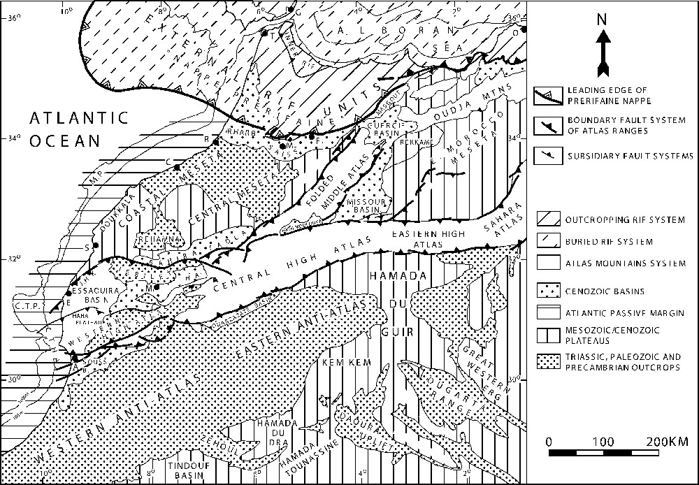
Physiographic provinces of Morocco: A, Agadir; C, Casablanca; C.T.H.A., Cap Tafelney High Atlas; C.T.P., Cap Tafelney Plateau; E, Essaouira; F, Fez; G, Gibraltar; J.H.K., Jbel Hadid-Kourati; M, Marrakech; Me, Meknes; MY, Mazagan Plateau; O, Oran; R, Rabat; S, Safi; T, Tanger.
Provinces physiographiques du Maroc.
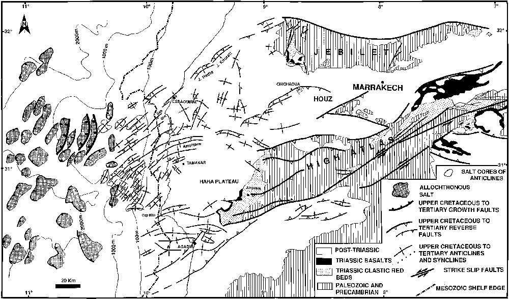
Structural sketch of the Jebilet Western High Atlas system (from [21]).
Schéma structural du Haut Atlas occidental et des Jebilet (d'après [21]).
A previous work proposed that the structural style of the Atlas belt changes eastward from a dominantly thick-skinned one in CEHA and MA of Morocco to a dominantly thin-skinned one in Algeria and Tunisia [14]. We propose to show here, by using regional seismic transects, that a similar structural style change can be observed in the other direction of the Atlas Belt within its western termination, where the WHA intersects at right angle the Atlantic passive margin. In fact, most of the available information on this area was dedicated to an understanding of its passive margin evolution, especially in the context of the Deep Sea Drilling Project (see references below). The important questions raised by the right-angle intersection with the WHA folded belt remained essentially unanswered. Previous works addressing the relation between the Atlantic and the Atlas did it mostly from a syn-rift paleogeographic view point [29,35,46] and the few works dealing with the structural aspects of this relation [13,31–33,45] did not raise the following important question: “How does the Atlas range terminate as it intersects the Atlantic margin?”. Recently, some of us have attempted to address this problem using more than 4500 km of industrial regional reflection profiles [18–21]. We propose to give an outline of this work complemented by several seismic transects from the Jebilet–Haouz and the Souss–Agadir offshore areas, interpreted by two of us (M.Z. and A.W.B.).
After briefly defining the tectonic and stratigraphic setting of the WHA basins, we will discuss the structural styles as they appear on selected regional seismic transects across these basins proceeding from the east to the west and ending with the offshore CTHA. Because of the difficulty to adequately reproduce strongly reduced original seismic profiles in a readable form and because of the limited space allotted to this paper, we will show only line drawings of these transects.
2 Tectonic and stratigraphy settings of the WHA
The WHA range covers several Atlantic coastal basins and their adjacent Atlantic shelf segment (Fig. 1). This large area evolved as a part of the Atlantic passive margin during Triassic to Lower Cretaceous times and from the Early Cretaceous as a proximal shallow-water platform of the Atlantic domain before being subjected, like the rest of the Atlas belt, from Upper Cretaceous on into the present, to a north–south to NNW–SSE-directed compression due to convergence between Africa and Europe. This compression resulted in reverse faulting, inversion of selected Triassic to Jurassic syn-rift structures and evaporite-based detachment folding (Figs. 1 and 2) [2,8,14,17,19,21,26,39,52,53].
The WHA was subdivided by Ambroggi [1] into several ENE–WSW-trending structural zones separated by faults or flexures [1] that have recorded different orogenic uplift rates [50]. Hafid [18] suggested that all these zones continue offshore into the CTHA [18] as we will show below. We will also illustrate the structural styles that characterize each one of these zones in land and analyze the seismic expression of most of the faults that separate them.
Some 100 km to the northeast of Marrakech, the HA splits into two branches corresponding respectively to the Precambrian/Paleozoic and Mesozoic outcrops of the WHA to the south (the High Atlas of Marrakech) and to the Paleozoic outcrops of the Jebilet to the north (Figs. 1 and 2). Conventionally the low-lying Jebilet hills are not included in the Atlas system, but in the present paper we will emphasize its importance as an integral part of the WHA [3]. The area between these two branches is occupied by the Haouz basin, which widens westward and is prolonged by the Essaouira basin that merges with the downplunge offshore continuation of the WHA and interrupts almost at right angle the passive margin of the Atlantic (Figs. 1 and 2).
The stratigraphy of the Meso-Cenozoic section of this large area has been extensively described, especially in the context of the Deep Sea Drilling Project (e.g., [23,24,28,49,53] and of several decades of hydrocarbon exploration efforts (e.g., [10,11]). Recently several papers reviewed the stratigraphy of certain of these basins based on subsurface data related mainly to this exploration effort [22,23,27,30–32,50]. Below, we will briefly describe the stratigraphy of each basin covered by our seismic transects, but only as much as is necessary for a good understanding of the structural styles, which is the main aim of the present paper. Fig. 3 shows the ages of subdivisions used on our seismic profiles and their correlations into the offshore Essaouira and the onshore/offshore Agadir basins. Fig. 4 is a simplified map showing the location of the composite profiles used to illustrate this work for the Essaouira–Agadir onshore and its offshore extension. The sections illustrating the Haouz–Jebelet zone are located in Fig. 2.
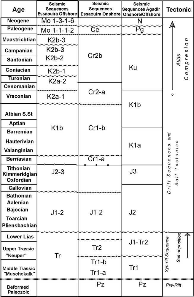
Age and correlation of seismostratigraphic subdivisions used in different basins of the studied area.
Âge et corrélation des subdivisions séismostratigraphiques utilisées dans les différents bassins étudiés.
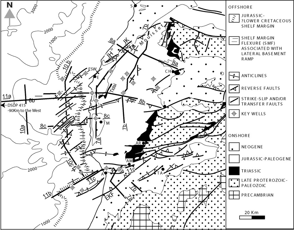
Main Atlasic trends of the western High Atlas and localisation of seismic trensects and key wells used in the present work: A, Agadir; AM, Ameskoud; AR, Agana; E, Essaouira; EKF, Elklea Fault; CH, Chichaoua; JH, Jbel Hadid; JK, Jbel Kourati; TA, Tarroudant; TM, Tamanar.
Directions structurales atlasiques principales du Haut Atlas occidental et localisation des coupes sismiques et des puits clés utilisés dans la presente étude.
3 Structural styles in the Western High Atlas
3.1 Jebilet
The Jebilet forms an elongated series of small hills located north of Marrakech (Figs. 1 and 2). It is formed by Paleozoic outcrops that show NNE-trending Hercynian structures. These structures are both basement-involved and décollement structures and consist of westward verging hanging wall anticlines and imbricates [25]. Their seismic analysis is not the object of the present paper. We will rather focus on the Atlasic structures and illustrate the proposition that the Jebilet massif must be considered as an integral part of the Atlas system [3]. To do this, we will use two north–south composite transects that cross the Jebilet Massif and that are dip sections with respect to the Atlas structures and strike sections with respect to the Hercynian ones. These transects show three main domains that are, from north to south (Figs. 5 and 6), the Bahira plain, the Jebilet Massif and the Haouz plain.
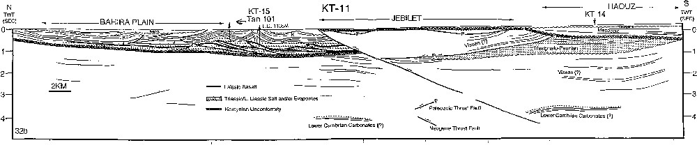
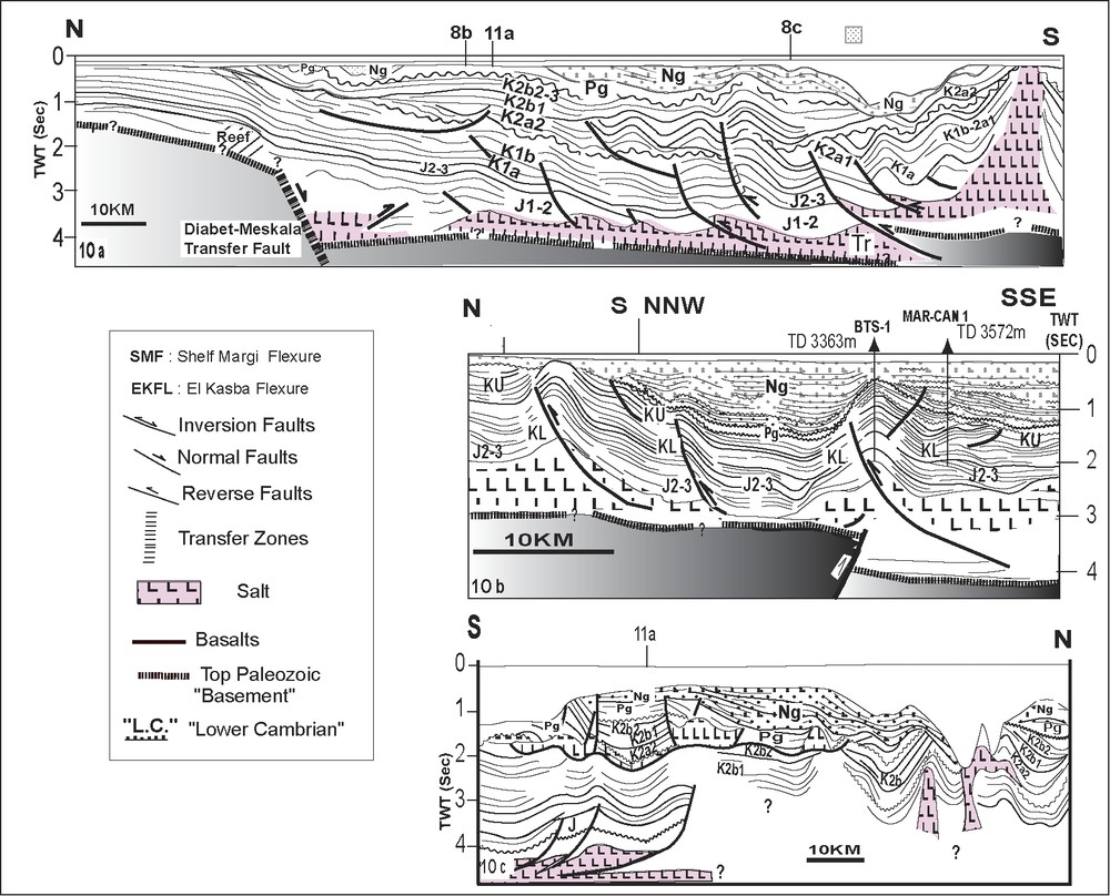
Line drawing of regional NS Transect KT11 across the Haouz plain, the Jebilet Massif and the Bahira plain. See Fig. 2 for the location of transects.
Interprétation de la coupe sismique régionale NS KT11 traversant la plaine du Haouz, le massif des Jebilet et la plaine de Bahira. Voir la Fig. 2 pour sa localisation.
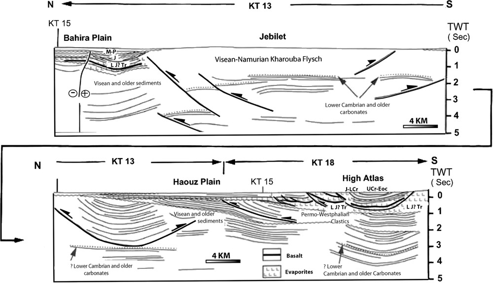
Line drawing of regional NS Transect KT13/KT18 across the Haouz plain, the Jebilet Massif and the Bahira plain. For location, see Fig. 2.
Interpretation de la coupe sismique régionale NS/KT13/KT18 traversant la plaine du Haouz, le massif des Jebilet et la plaine de Bahira. Voir la Fig. 2 pour sa localisation.
As is imaged in the transect of Fig. 5, the Bahira plain is underlain by a southward-thickening wedged post-Paleozoic section, which was partially drilled by the TAN-1 well and which is affected by a short cut of a major reverse south-dipping reverse fault that thrusts the Jebilet massif to the north on the southern margin of the Bahira plain. This short cut marks the transition from thick-skinned deformation in the northern limit of the Jebilet to thin-skinned deformation with a décollement level at the base of the Triassic salt. A mini-folded belt was identified in the Bahira basin (Fig. 5).
The Atlas orogeny resulted thus in a major north-verging reverse fault that thrusts the Jebilet Massif to the north on the Neogene (Plio-Villafranchian) section of the southern margin of the Bahira plain [25]. The vertical uplift of this fault is estimated to be 1500 m and its horizontal offset is approximately 4 km (Fig. 5). This clearly suggests that the actual major North Atlas fault must be traced at the north of the Jebilet (Figs. 1 and 2) and that the most external frontal structures of the western High Atlas are located within the Bahira plain (Fig. 5). This North Jebilet fault was also shown to have played, already in Triassic to Liassic times, an important role in the structural evolution of the area [29].
The seismic lines that cross the Jebilet massif show that it consists of a Lower Cambrian to Upper Devonian unit overlain by a thick Carboniferous section, which were both deformed during the Hercynian orogeny (Figs. 5 and 6). Though the analysis of this deformation is out of the scope of the present work, it is interesting to notice that the northerly-oriented structures that it generated strike at right angle with respect to the much younger Atlas structures. The southern flank of the Jebilet dips gently under the Haouz plain (Figs. 5 and 6). This latter appears on the seismic study as a foreland with respect to the major fault separating it from the High Atlas to the south. This fault is considered in all previous works as the North Atlas Fault. The Mesozoic to Neogene section of the Haouz basin is less thick and less deformed than that of the Bahira foreland. The intensity of its deformation, however, increases conspicuously eastward.
3.2 Essaouira onshore
Because of its hydrocarbon potential, the Essaouira onshore is one of the most studied zones of Morocco [1,2,5,10,11,18–20,27,31,32,35,39]. Broughton and Trepanier [8] outlined the geological setting and possible source rocks of its hydrocarbon fields. The Essaouira onshore basin appears in north–south regional composite transects as a broad synclinorium between the compressional uplifts of the Jebilet and the western Atlas (Fig. 7b) and in east–west transects as a wedge onlaping on the West Jebilet Plung (Fig. 8a). This broad structure, which is filled with syn-rift and post-rift formations, clearly displays the post-Cenomanian uplift of the Range. We propose to first analyze the underlying syn-rift Triassic/Early Liassic extensional structures and their associated sag system before illustrating the structural styles associated with this alpine compressional uplift. The equivalent of the thick red beds that filled these Triassic/Liassic structures are largely outcropping and well studied in the Argana valley south of the Essaouira Basin [35,39,48].
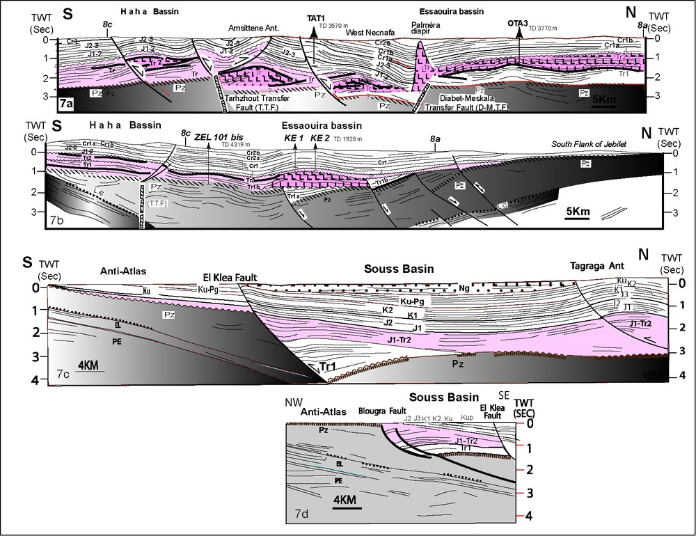
Line drawing of four north–south seismic regional transects across Essaouira and Agadir onshore basins. See Fig. 4 for location of transects and Fig. 10 for legend.
Interprétation de quatre coupes sismiques régionales nord–sud traversant les bassins onshore d'Essaouira et d'Agadir. Voir la Fig. 4 pour la localisation et la Fig. 10 pour la légende.

Line drawing of three east–west seismic regional transects across Essaouira onshore (a) and Essaouira onshore/offshore (b and c). See Fig. 4 for location of transects and Fig. 10 for legend.
Interprétation de trois coupes sismiques régionales est–ouest traversant les bassins d'Essaouira onshore (a) et d'Agadir onshore (b et c). Voir la Fig. 4 pour la localisation et la Fig. 10 pour la légende.
3.2.1 Triassic/Early Liassic structures
Fig. 9 shows that the general trend of these extensional syn-rift structures is here north–south to NNE–SSW and that they are segmented by east–west transform faults. The line drawings of Figs. 7a and b and 8a–c illustrate well their subsurface geometry and show that they are unconformably overlain by an Early Liassic sag basin that is essentially unfaulted and contains most of the salt as well as the most widespread basalt flows that appear sandwiched between evaporites. This sag basin is sealed by a seismically conspicuous unconformity, which is commonly considered as the break-up unconformity and for which fieldwork suggests a pre-Carixian/Domerian age [35]. The age of the horizons that onlap on it are progressively younger northward and eastward, as can be seen in our north–south (Fig. 5c) and east–west (Fig. 6a) regional transects and as is confirmed by surface data [35]. Likewise, these transects show an eastward and northeastward pinchout of the sag sequences against the pre-Jurassic. This pinchout coincides with the west flank of the West Moroccan Arch (i.e. the “dorsale du massif Hercynien central” of Du Dresnay (1972)) [9,39] that separates the Tethys domain from the Atlantic domain.
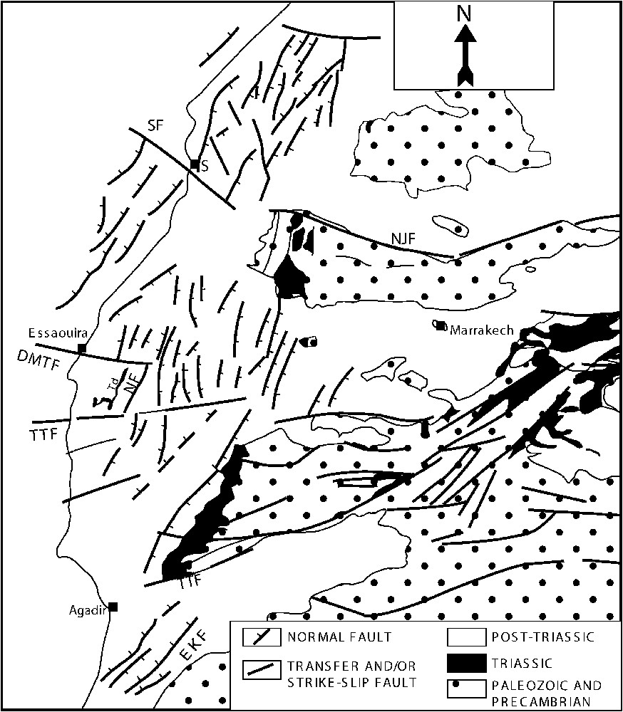
Upper Triassic normal and transfer faults of western Morocco mapped from seismic and magnetic data for the coastal basins and their corresponding shallow Atlantic shelf, and from existing surface maps for the Jebilet and the High Atlas. Named faults: DMTF, Diabet Meskala Transfer fault; EKF, El Klea fault; TTF, Tarhzout Transfer fault; TTF, Tizi n'Test fault; NF, Necnafa fault; SF, Safi fault; NJF, North-Jebilet fault; Td, Tidsi salt diapir.
Carte de la fracturation triasique du Maroc occidental, basée sur les données sismiques et magnétiques pour les bassins côtiers et leur extension au niveau du plateau continental et sur les données de surface existantes pour les Jibelet et le Haut Atlas. Nom des failles : DMTF, faille de transfert Diabet Meskala ; EKF, faille d'El Klea ; TTF, faille de transfert Tarhzout ; TTF, faille de Tizi n'Test ; NF, faille de Necnafa ; SF, faille de Safi ; NJF, faille Nord-Jebilet ; Td, diapir salifère de Tidsi.
Several of the east–west faults that we interpreted as transfer faults (Fig. 9) are shown on our transects with a basement-offsetting component. Except for the Diabet–Meskala fault (Fig. 7a), which shows a significant basement offset, the evidence for these faults is weak. The much more hypothetical deep Tarzhout–Ihchich Fault transfer system (T.T.F. in Fig. 7a and b) is postulated to explain the east–west-trending northern boundary structures of the Western Atlas (see below).
3.2.2 Atlas structures
The Atlas compression resulted in the Essaouira onshore in: (i) the inversion of selected Triassic faults, as can be seen in Figs. 7a and b and 8a–c and can be also inferred by comparing the Triassic to Liassic faults' map (Fig. 9) with the Atlas anticlinal structures (Fig. 2), and in (ii) the formation, in the eastern Essaouira onshore, of broad post-Upper Cretaceous compressional salt anticlines, of which the drilled KE structure is a good example (Fig. 7b). Most of these structures may be essentially of Tertiary compressional origin, but the truncation of the basalt horizons by the base J1–2 unconformity within certain of them (e.g., KE, Fig. 7b) suggests also the presence of earlier salt growth pillows.
The section of Fig. 8b crosses from east to west the main platform of the Essaouira Basin underlain by a Triassic horst corresponding to the Meskala High (MKL well), and the Cap Sim Necnafa embayment (West and East Necnafa embayments of Broughton and Trepanier [7]), which is an important structural depression that contains the most mature salt structures of the basin, of which the most important is the outcropping Tidsi diapir (Fig. 4) [7,18,19]. The role of salt withdrawal in the spectacular thickening of the Jurassic and Cretaceous sections within the Necnafa embayment, as is conspicuously shown by Figs. 7b and 8b, is discussed in detail elsewhere [18,22]. These studies concluded on the basis of seismostratigraphic analysis that most of the large salt structures present in this area (e.g., Tidsi and Tab, Fig. 8b and Palmera, Fig. 7a) were likely well formed prior to the incipience of the Atlas compression and suggested that the east–west and NE–SW-trending branches of the Tidsi salt structure were probably pre-ordained by similarly trending older Triassic faults (Fig. 9). The Tidsi structures reached the diapir stage by Upper Jurassic time and were simply reactivated as compressional folds during the Atlas orogeny rather than being initially due to two differently oriented compressional phases, as was suggested by previous fieldwork (e.g., [2]).
The north–south sections of Fig. 7a and b cross the boundary between the Essaouira basin and the northern Sub-Atlas zone of Ambroggi [1]. They show this boundary to consist of an important post-Albian (post Cr1b) reverse fault associated with the Amsittene anticline and that is shown superimposed on a somewhat hypothetical deep Triassic fault transfer system, namely the Tarzhout–Inhech Fault (T.T.F. in Fig. 7a and b), which we postulated to explain this east–west-trending northern boundary reverse fault of northern Sub-Atlasian zone of the WHA.
Finally, the section of Fig. 8a follows the trend of the southern flank of the Jebilet and crosses the Jbel Kourati anticline, which together with the Jbel Hadid anticline constitute the most northwesterly Atlasic structure of the basin (Figs. 2 and 4). It is shown by this section as a partially inverted Triassic graben system. As shown in Figs. 1, 2 and 4, we suggest that the North-Jebilet fault system swings into a southwesterly direction to be relayed by the NE–SW trending compressional structures that Huvelin [25] mapped in the Mouisset area [25]. We interpret these surface anticlines and flexures on the light of the structural style defined from seismic study, as underlain by blind reverse faults that are relayed to the southwest by the cropping out Jbel Hadid and Jbel Kourati inversion anticlines (Fig. 8a). All these most northwesterly onshore structures together with similar most north-westerly offshore structures (e.g., the drilled ESW1 structure, Fig. 4) represent the frontal structures of the northern forelands of the WHA (Figs. 1, 2 and 4) (see discussion below).
3.3 The offshore Essaouira Basin
The transition from the onshore Essaouira–Haha coastal plain to the offshore is illustrated by the east–west sections of Fig. 8b and c. These sections show that the near-coast shelf is underlain by an uplifted shallow Jurassic to Lower Cretaceous shelf margin with a pronounced Tertiary shelf margin flexure (SMF of Hafid et al. [21]). This flexure can also be inferred by comparing the depth of the Hercynian basement top along these profiles. In profile 8b, the basement below the Cap Sim well in the offshore is much deeper that below the Tab 1 well in the coastal shelf. The Cap Sim well bottomed at 3048.5 on top of a salt dome that is rooted in a much deeper (more than 3.5 s) Triassic salt layer, whereas the Tab 1 well bottomed at 1200 m and did not reach the evaporite-cored structure whose base is estimated to be around 3 s here. Still farther to the east, the basement underling Sidi Rhalem oil field (RH) is much shallower (about 1.3 s). Farther south, profile 8c, particularly well illustrates this SMF, as well as the remarkable westward plunge of the WHA (the northern Sub-Atlas zone of Ambroggi, 1963 [1]) and its Hercynian basement into the offshore Atlantic, where it lies at a depth of more than 5 s.
Because the east–west profiles are strike profiles with respect to the Atlas system, we suggest that the structures they show are parts of a complex lateral ramp of this system that uplifted the Mesozoic carbonate shelf margin and flexured the overlaying Upper Cretaceous to Tertiary strata. These lateral ramps can also be seen in another oblique direction in the north-south profile of Fig. 10a, which crosses the east–west profiles shown in Fig. 8b and c. Profile 10a is located some 20 km to the west of the Mesozoic carbonate shelf margin (Fig. 4) and is thus located within Cap Tafelney deep water basin where the Upper Cretaceous (K2a-2 to K2b-3 units) and the Paleogene to Neogene (Mo1–1 to Mo1–5 units) intervals are characterized by a regional conspicuous southward thickening. As is shown by profile 11a, the angular unconformity that dates the inception of deformation within the Cap Tafelney basin corresponds to the base of the K2a-2 seismic unit, which is roughly dated Mid-Cenomanian according to industrial tops from the nearby Cap Sim 1X well (Fig. 8b). This resulted in NE–SW-trending structures of the CTHA (Figs. 2 and 4), which are separated from an underformed northern foreland by a westerly swing of the northerly Mesozoic shelf edge, which itself coincides with the east–west Diabet–Meskala transfer Triassic fault (Figs. 9 and 10).
Line drawing of three north–south seismic regional transects across the Agadir/Essaouira offshore illustrating allochthonous salt pods in the upper slope, Essaouira offshore (a), the CTHA folds in the Essaouira offshore (b) and the CTHA folds in the Agadir offshore (c). See Fig. 4 for location of transects.
Interprétation de trois coupes sismiques régionales nord–sud à travers le bassin d'Agadir/Essaouira offshore illustrant (a) les masses salifères allochthones de la partie supérieure de la pente continentale d'Essaouira offshore, (b) les structures plicatives du Haut Atlas du cap Tafelney, dans le bassin d'Essaouira offshore, et (c) les structures plicatives du Haut Atlas du cap Tafelney, dans le bassin d'Agadir offshore. Voir la Fig. 4 pour la localisation des coupes.
Finally, an east–west transect crossing entirely the Cap Tafelney basin (Fig. 11a) and a north–south section crossing the middle slope (Fig. 10c) show that subsequently to its deposition, salt migrated in the basin, by gravity and compression, from the base to the top of the section and from east to west. This led to complex salt-related structures including large completely allochthonous salt bodies and upthrusted salt tongues in the Mid- and Lower slope that end by a toe-thrust zone in the vicinity of DSDP 415 some 90 km to the west of the western end of transect 11a (Fig. 10c) [19,22,47].
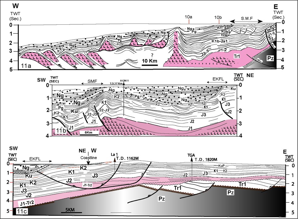
Line drawing of an east–west seismic transect crossing the Cap Tafelney Basin, the salt based raft-structures and the upthrusted salt tongues of the middle and lower slope of the Essaouira offshore (a), a NE–SW transect in the offshore Agadir illustrating the near-shore Elkasba flexure and the Shelf Margin Flexure (b) and an east–west transect illustrating the transition from the onshore to the offshore Agadir basin. See Fig. 4 for the location of transects and Fig. 10 for legend.
Interpretation (a) d'une coupe sismique est–ouest à travers le bassin du cap Tafelney, illustrant les structures salifères en radeau et les langues salifères chevauchantes de la partie médiane de la pente continentale d'Essaouira offshore, (b) une coupe NE–SW dans l'offshore d'Agadir, illustrant la flexure d'Elkasba et la flexure de bordure de marge et (c) une coupe est–ouest illustrant la transition de l'onshore à l'offshore d'Agadir. Voir la Fig. 4 pour la localisation des coupes et la Fig. 10 pour la légende.
3.4 The Souss onshore and the Agadir offshore basins
The Souss basin is an east–west onshore Neogene basin that was subdivided by Ambroggi [1] into two structural zones: the southern Sub-Atlasian and the Souss Synclinal zones. The first covers the northern part of the basin immediately south of a branch of the Tizi n'Test Fault (TTF) that separates the Triassic and Paleozoic outcropping to the north and east of Ameskoud from the Neogene and continues westward towards the Atlantic, and the second is limited from the north by another branch of the TTF that passes north of Agadir [37] (Figs. 1 and 4). To the east of Ameskoud, the TTF shows a steep south-verging Neogene/Recent reverse throw and farther east it overthrusts a complex system of compressional structures that involve Paleozoic, and Cretaceous to Neogene sediments and corresponds to a reactivation of a Triassic to Jurassic Normal fault system [37]. In the present work we will focus, however, on the western Souss plain and its adjacent offshore Atlantic segment by analyzing their structural styles as they are imaged by seismic composite profiles.
These profiles show that the Meso-Cenozoic and the Neogene sections of the Souss basin thicken to the north (Fig. 7c and d) and to the west (Fig. 11c) and pinch out against the paleo-high of the Anti Atlas (Fig. 7c and d). The Neogene section appears thus in profile 7c as a broad synclinorium located between the southern flank of the Tagragra anticline to the north and the southwest plunge of the anticline associated with the El Klea fault. This latter appears in this profile as northwest-facing Triassic normal faults which have been mildly inverted during the Tertiary. Some 10 km to the northeast, another profile shows in addition to El Klea fault the Biougra fault (Fig. 7c), which however was not inverted [42]. Both faults sole out on top of north-dipping strong crustal reflectors that probably project southward within or at the base of the Adoudounian Cambrian carbonates cropping out in the Anti Atlas. The El Klea structure and the outcropping Tagragra anticline seen on profile of Fig. 7c represent frontal structures of the southern foredeep of the WHA (Fig. 2). The Tagragra anticline is interpreted here as an evaporite-based décollement fold. Frizon de Lamotte et al. [14] interpreted it as a fault bend fold with two décollements levels one in the Triassic–Lower Lias and the other one in the Paleozoic. In any case, the TGA2 well encountered salt and demonstrated that it is a salt-cored anticline.
Farther to the northeast, north and northeast of Tarroudant, a series of asymmetric anticlines associated with narrow synclines outcrop in front of the Ancient Massif (Figs. 2 and 10). Frizon de Lamotte et al. [14] described these outcrops and reported variations of thickness of the Upper Cretaceous and younger strata between forelimbs where the sedimentary section is reduced and the backlimbs where the sedimentary section is thicker and complete [14]. This geometry is typical of piggy-back basins related to the uplift of the Atlas System and the deformation of the northern end of the foreland at the vicinity of southern limit of the chain.
The composite profile of Fig. 11c shows in a strike view direction the Tagragra (TGA) and the Ait Lamine (La-1) anticlinal structures. Its western part crosses the coastline and suggests that the La-1 structure is a salt-based décollement fold with a western lateral ramp that is associated with a flexure (EKFL on the profile) that is characterized by an updip convergence of Neogene horizons, which is reminiscent of the ‘éventail de pendage’ reported from the field farther north in Haha [2,44]. This flexure, which can also be seen on the offshore NE–SW-trending profile 11b, was shown by detail seismic analysis to be associated with the Elkasba blind fault [41]. This suggests that this structure may still be active today as was also concluded by previous works from the analysis of the Quaternary marine terrace elevations along the coast [14,38] and is also suggested by the 1960 Agadir earthquake (Ms 5.6).
Finally, a rapid analysis of the offshore profiles 10b, 11b and 11c shows that the Agadir offshore area is characterized by the same structural style of deformation as what we saw farther north in the Essaouira offshore. Here we have again salt-based décollement folding but with a more conspicuous piggy-back geometry showing thick foreland and hinterland Neogene synclines, such as the very thick (more than 1 s) syncline that appears in section 11b sandwiched between the uplifted Mesozoic shelf margin to the southeast (SMF) associated with the south-western termination of the AGM anticline and the near-shore Elkasba flexure (EKFL). This geometry is also seen in the north–south section of Fig. 10b, which represents the southward prolongation of the north–south offshore Essaouira profile 10a into the offshore equivalents of the axial and southern zones of the WHA as defined by Ambroggi [1]. As can clearly be seen in all these three profiles, the base of the Neogene section is a major unconformity on which Neogene strata onlaps and which truncates with top-laps the underlying Oligocene to Eocene (Pg) and Cenomanian reflections (Ku). The base of Paleogene is itself an unconformity that truncates the Upper Cretaceous reflections. This suggests that, like the Essaouira offshore, the Agadir offshore bas been subjected to contractional stresses from Upper Cretaceous up into the present. This is in agreement with the deformation ages based on field observations in the onshore basins as we will discuss below.
4 Discussion and conclusions
Regional seismic transects that across the WHA basically corroborate the sequence of events proposed by previous studies for its Meso-Cenozoic evolution: a Late Triassic–Early Liassic extension resulted in NNE–SSW striking halfgraben linked by transfer faults and overlain by a hardly faulted Early Liassic sag basin where most salt and basalts were deposited. This sag basin is in turn overlain by Jurassic and Cretaceous platform deposits. From Upper Cretaceous on into the Present the WHA was subjected to NNW–SSE-directed compression that resulted in the inversion of selected syn-rift structures and in salt-based detachment folding in the Souss, Bahira and Haouz forelands and in the offshore CTHA.
In contrast with the syn-rift system of the CEHA and the MA that opened essentially during Liassic to Upper Jurassic times and accumulated relatively less salt [30,51,52] the syn-rift system of the WHA opened from Upper Triassic to Liassic times and accumulated a thick salt section [19,20,31,32]. We suggest that it is the post-deposition behavior of this thick Triassic salt that is responsible for most of the tectono-stratigraphic differences that the WHA shows with respect to the other segments of the Atlas system, as we will discuss below.
Our regional seismic transects show that the Atlas compressional deformation is differently distributed across the WHA with respect to the CEHA and the MA. Whereas in these latter segments, deformation is characterized by a dominantly thick-skinned style and shortening is essentially accommodated at the outer fronts of the belt [14–17,39], in the WHA deformation is relatively more evenly distributed across the belt, with a noticeable change in style, from east to west however. In fact, the eastern part of the WHA and its coastal onshore segment are characterized by a mixed thick-skin/thin-skin style, whereas its most western segment, the CEHA, is characterized by thin skin deformation.
In the eastern part of the WHA, the northern front is a double front characterized by a thick-skin/thin-skin–thick-skin/thin-skin style seismically revealed within the High Atlas of Marrakech/Haouz–Jebilet/Bahira areas, respectively (Figs. 5 and 6). Two minor salt-based décollement foreland belts are thus seen in the eastern parts of the Bahira and the Haouz foredeeps. This clearly suggests that the Jebilet hills that overthrust the Bahira to the north must be considered as an integral part of the WHA and that the actual major North Atlas fault must be traced at the north of these hills with the most external frontal structures of the WHA located within the Bahira plain (Figs. 1, 2 and 5). In the southern side of the WHA, the eastern part of the Souss Basin shows a similar style of deformation, but with only a single front characterized by thick-skin/thin-skin with salt based décollement in the foredeep [14,42].
Farther to the west, in the Essaouira/Agadir onshore zones, the Atlas compressional and/or transpressional tectonics caused (i) broad evaporite-based compressional pillows, especially in the central and eastern Essaouira Basin, (ii) mini-inversion of the NE–SW-trending Triassic halfgrabens of the Jbel Hadid–Jbel Kourati (Fig. 8a) in the northwestern Essaouira Basin and of the El Klea fault in the southeastern Souss Basin (Fig. 7c and d) and possible salt-based décollement folding in Haha and in the western Souss Basins. The inverted Hadid–Kourati and El Klea structures represent frontal structures of the northern and the southern forelands of the WHA, respectively (Fig. 2). This northern front consist, in addition to the Hadid–Kourati fault, of the NE–SW-trending compressional structures present in the Mouisset area [25], the North-Jebilet fault and similarly trending most northwesterly offshore structures (Figs. 2 and 4). In the Souss Basin, the El Klea fault that represents the southern front, probably continue farther offshore than our maps show. No seismic data exits however in this area (Figs. 1, 2 and 4).
The east–west subsurface transfer faults (Fig. 9) are also good candidates for inversion by the Atlas compression. However, except for the Jebilet fault, the existing seismic data quality does not satisfactorily resolve their geometry. On a smaller scale, the reactivation of similar subparallel faults are reported from the Argana Basin [36]. Ambroggi [1] proposed regional cross sections across the onshore WHA, which imply evaporite-based décollement folding [1,39]. This style can also be implied by some of our transects, such as the one shown in Fig. 7a, which crosses the Amsittene structure that Bouatmani et al. [6] interpreted as a salt-based complex fault-bend fold. Better quality seismic data that can adequately image the top of the Paleozoic basement in this area is, however, needed before definitively resolving this situation.
In the offshore Essaouira, the Upper Cretaceous to Neogene section thickens dramatically southward (Fig. 10a) suggesting deposition in a flexural basin that responded to tectonic loading of the offshore extension of the axial zone of the WHA. In fact, this offshore axial zone is characterized by the same salt-based décollement folding as that of the Essaouira offshore, but with a more conspicuous piggy-back geometry showing thick foreland and hinterland Neogene synclines (Fig. 10b). The angular unconformity that dates the inception of deformation is, according to available industrial tops, roughly Middle to Upper Cenomanian in the Essaouira and the Agadir offshore. This unconformity together with the younger ones seen in these sections are probably due to strong down-slope currents that truncate the crest of growing anticlines and do not necessarily offer evidence for distinct, short-lived phases of deformation. The available seismic data do not resolve the basement underlying the Triassic in Essaouira/Agadir offshore basin. However, the ubiquitous presence of salt over most of the area attested by drilling (Fig. 2) strongly suggests an evaporate-based décollement folded belt.
Our conclusions related to the age of the WHA compression as defined by tectono-seismostratigraphic analysis of profiles crossing the Essaouira–Agadir offshore basin are corroborated by similar conclusions suggested by tectonostratigraphic evidence based on several field works [1,10,11,15]. These studies concluded that the age of the Atlas deformation is Late Cretaceous to Paleogene. In fact, in the onshore Essaouira Basin Upper Cretaceous unconformities have been reported by previous studies that explained the reworking of Cenomanian foraminifera in Senonian strata as due to emerging areas in the Haha embayment [1,10,11]. Farther south, in the Souss foreland basin, field observations indicate that the Atlas deformation was active between the Eocene and the Oligocene and during the Pleistocene and the Lower Quaternary [1,14].
The shelf edge of the Essaouira/Agadir offshore is characterized by a shelf margin flexure that is characterized by monotonous gently dipping reflections showing updip convergences (Figs. 8b and c, 11c and b) that roughly coincide with the Mesozoic shelf edge (Fig. 4). This shelf edge flexure indicates a Neogene uplift that confirms the Late Neogene uplift of the Atlas range mapped by Faure Muret et al. [12]. The monotonous gently dipping structure that characterizes the transitional zone from the platform to the basin in the Agadir offshore (Fig. 10b) makes it difficult to postulate, as did previous studies (e.g., [13,23]) the existence of a major stricken-slip fault offsetting Mesozoic and Tertiary strata and representing the southwestward prolongation of the South-Atlas Fault, whose western inland segment is known as the Tizi n'Test Fault [13,23,26,37].
Finally we conclude that at the scale of the entire Atlas belt, a similar change in the structural style from a dominantly thick-skinned one to a dominantly thin-skinned one is observed both eastward from the CEHA to the Algerian and Tunisian Atlas [14] and westward from the CEHA to the CTHA where the High Atlas intercepts the Atlantic passive margin (Figs. 1 and 2). The main cause of this along-strike change in the deformation style is related to the presence of Triassic–Lower Liassic evaporites in quantities thick enough to provide a basal décollement in these extremity segments of the belt.
Acknowledgements
This study would not have been possible without the assistance of the ONHYM (‘Office national des hydrocarbures et des mines’, Rabat). We particularly would like to thank Mr A. Ben Khadra, General Manager, and Mr. A. Morabet, Operating Manager, of the ONHYM for their support and for kindly making the seismic profiles available for this study. We also thank Ms C.J. Liu for her help in drawing some of the illustrations.