

Version française abrégée
Introduction
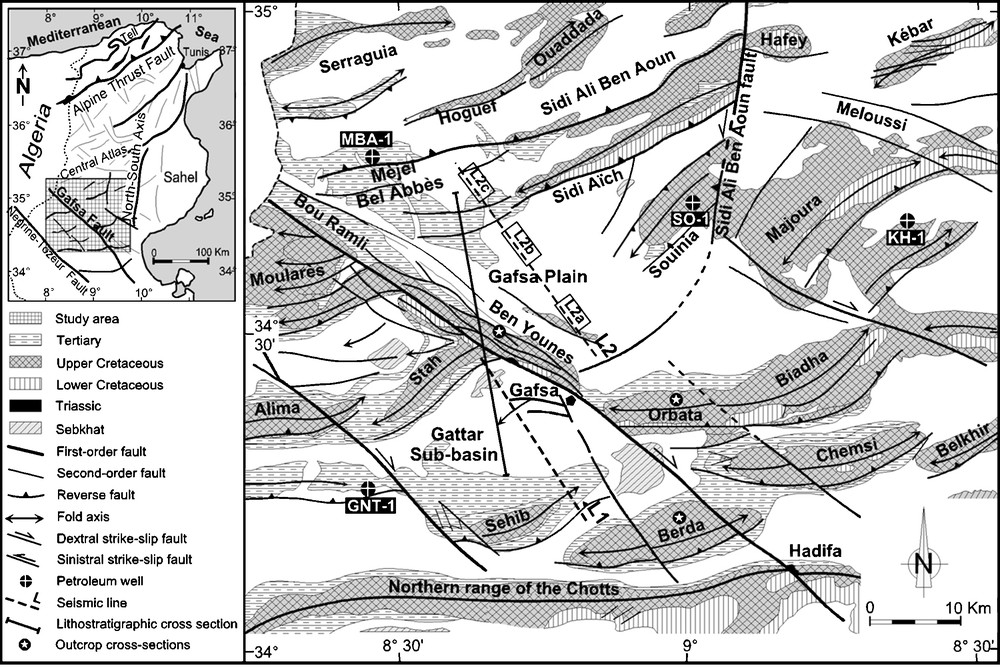
Le secteur d’étude est caractérisé par des plis orientés est–ouest, NW–SE et NE–SW, à vergence sud (Fig. 1), correspondant aux couloirs de failles en décrochement à intrusion triasique [5,6,11,12,28–32] et contrôlant la répartition des dépôts sédimentaires par ses réactivations ultérieures (Figs. 6 et 7). L’intervalle Turonien débute par le massif dolomitique de la barre Gattar [2,3,7–9,13,14,18,25,26], suivi par les calcaires marneux d’Annaba et la succession de calcaires dolomitiques de Biréno [3,13,27]. Au Jebel Ben Younes (région de Gafsa), la barre de Gattar est surmontée par les anhydrites de la formation Beida [3,9,13,18], récemment attribuées au Turonien inférieur [3]. Les alternances de calcaire, d’argile et d’évaporite d’âge Turonien révèlent un environnement néritique interne dans l’Atlas central et méridional de la Tunisie [13,18]. Les niveaux carbonatés correspondent à une large plate-forme, plus étalée vers l’est et vers le nord. Cependant, le faciès évaporitique rencontré dans la plaine de Gafsa est caractéristique d’une sédimentation dans un milieu isolé [3,9,13,14]. Ce changement lithologique est associé aux variations d’épaisseurs (Figs. 2 et 6). L’étude combinée des données sismiques (faciès et vitesses sismiques) calées aux puits pétroliers et aux affleurements a été effectuée dans le but de déterminer l’évolution stratigraphique et structurale des dépôts turoniens dans les bassins de Gafsa.
Geological and tectonic setting of the central Tunisian Atlas (Gafsa area), showing the location of main surface and subsurface tectonic features (after [5], modified).
Fig. 1. Carte géologique et tectonique de l’Atlas tunisien central (région de Gafsa), montrant l’emplacement des principaux linéaments tectoniques identifiés en surface et en subsurface d’après [5], modifié).

Lithostratigraphic distribution model of the Turonian depositions along the Gattar and Mèjel Bel Abbès sub-basins, showing the facies changes between the different structures.
Fig. 6. Modèle de la distribution lithostratigraphique des dépôts turoniens le long des bassins Gattar et Mèjel Bel Abbès, montrant les changements de faciès entre les différentes structures.
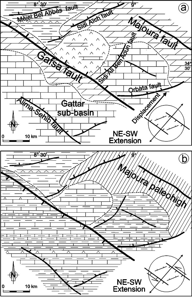
Turonian structural model, showing the effect of the stress field on the palaeogeographic distribution. (a) Lower Turonian, (b) Middle to Upper Turonian. The structural inversion along the Gafsa fault is associated to the rise of the Triassic salt.
Fig. 7. Modèle structural du Turonien, montrant l’effet du champ de contrainte sur la répartition paléogéographique. (a) Turonien inférieur, (b) Turonien moyen et supérieur. L’inversion structurale le long de la faille de Gafsa est associée à la montée du sel triasique.
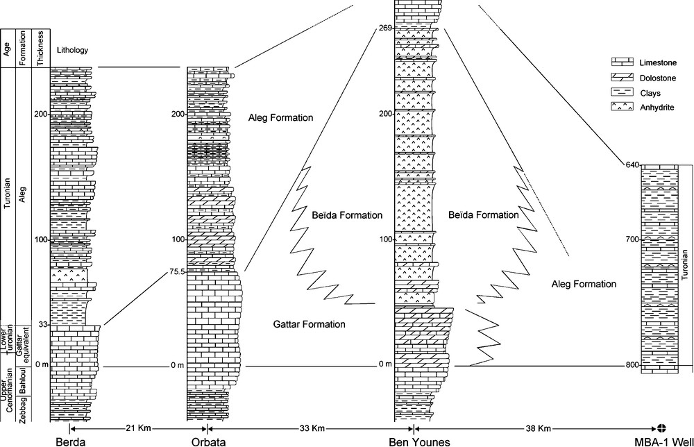
Turonian lithostratigraphic correlation across the Gafsa area, showing facies and thickness variations between the main depressions and palaeohighs.
Fig. 2. Corrélation lithostratigraphique des dépôts Turoniens à travers la région de Gafsa, montrant des variations d’épaisseur et de faciès entre les zones basses et soulevées.
Distribution profonde des dépôts turoniens
La compilation des données géologiques et sismiques montre une variation de la distribution des dépôts turoniens, une tectonique synsédimentaire et un héritage structural. Cette structuration associée aux intumescences triasiques a contrôlé la répartition paléogéographique (Figs. 2, 6 et 7). Les ensembles lithostratigraphiques du Turonien, épais au centre des dépressions, se réduisent vers les bordures soulevées, où ils sont limités par des discordances majeures (Figs. 2, 3a et 7b). Ces dépôts sont matérialisés par des unités aggradantes et progradantes entre les structures des dépressions et des plates-formes. La barre Gattar correspond à un doublet sismique formant une gouttière synclinale, sur laquelle la sédimentation turonienne montre un changement de la répartition des dépôts (Fig. 3a). Ce changement coïncide avec une inversion régionale de la structuration ayant eu un effet sur la nature de faciès des dépôts sédimentaires.
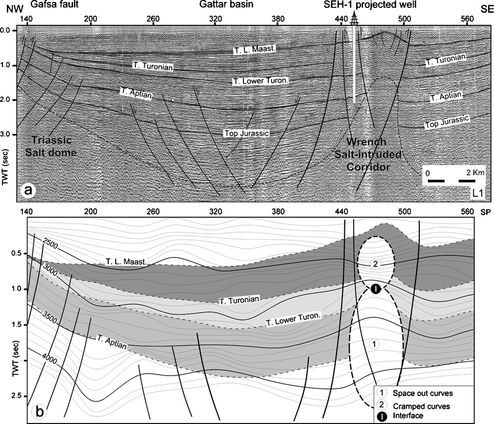
Iso-velocity section and the corresponding seismic line L1, showing the lateral and vertical velocity changes in the southern Gafsa sub-basin, the east-west Sehib wrench salt-intruded corridor, and the Triassic salt dome towards the master Gafsa fault. The interface between the two velocity layers corresponds to the Triassic ceiling (vertical scale of the iso-velocity section is modified). (a) Seismic section, (b) iso-velocity section.
Fig. 3. Section d’iso-vitesse et ligne sismique correspondante L1, montrant les changements latéraux et verticaux de vitesse dans le bassin sud de Gafsa, le couloir est–ouest à intrusion salifère et le dôme triasique vers la faille de Gafsa. L’interface entre les deux ensembles de vitesses correspond au toit de ride triasique (L’échelle verticale de la section iso-vitesse est redimensionnée). (a) Section sismique, (b) section iso-vitesse.
Implications des vitesses sismiques
Toit des intrusions triasiques du Sehib
La section des vitesses de sommation étudiée traverse la dépression Gattar et passe par l’extrémité est du Jebel Sehib (Figs. 1 et 3). À l’extrémité nord-ouest de la section (Fig. 3a), les courbes iso-vitesse, qui sont sub-parallèles sur la pente, deviennent plus espacées vers la base du talus (Fig. 3b). Le changement du gradient de vitesse indique une variation latérale et verticale des dépôts sédimentaires, qui évoluent d’un faciès carbonaté, sur la pente, vers des alternances des carbonates et d’argiles, près de la dépression. Latéralement, vers le sud-est, au niveau de la zone élevée, les vitesses montrent une configuration convergente, matérialisée par un rapprochement des courbes iso-vitesse à l’aplomb de la structure plissée de Sehib (Fig. 3b). Deux ensembles ont été identifiés au niveau de cette structure ; le premier montre des courbes iso-vitesse espacées, correspondant aux strates homogènes des sels triasiques représentés sur la section sismique par un faciès chaotique. Le second, plus contrasté, indique un changement lithologique correspondant aux alternances du Turonien moyen et supérieur. La limite entre ces deux gradients de vitesse est interprétée comme étant le toit de la ride triasique (Fig. 3b). L’étude sédimentologique [3] et les données du puits SEH-1 montrent un effet limité du mouvement ascensionnel du matériel triasique sur la distribution sédimentaire. Les intrusions triasiques induites par des mouvements en coulissement des failles bordières ont été à l’origine des structures en rides salifères qui délimitent le dépocentre du Gattar, au nord, et la zone soulevée de la chaîne nord des Chotts, au sud (Fig. 3).
Les mouvements halocinétiques qui ont débuté au Jurassique ont continué leur ascension pendant les périodes crétacées. Ses effets sur les dépôts du Turonien ont été mis en évidence par des inversions structurales. Durant les déformations en extension, le mouvement de sel a contrôlé la distribution de la sédimentation et l’emplacement des structures associées. Les déformations ultérieures en compression favorisent la rémobilisation du matériel salifère, qui a accentué les phénomènes de soulèvement. Ce faciès constitue un niveau de décollement à la base des dépôts sus-jacents et contribue à leur déplacement et, par conséquent, à la formation des structures chevauchantes inverses (Fig. 3).
Répartition lithostratigraphique des dépôts turoniens
La carte des vitesses d’intervalle montre une variation latérale du champ de vitesse, liée à la répartition des dépôts turoniens à travers les structures de Gafsa (Fig. 4). Les valeurs de vitesse les plus élevées dans le bassin Gattar ont été détectées au niveau des structures de pente et de plate-forme de Ben Younes, indiquant l’abondance des dépôts carbonatés. Dans la plaine de Gafsa, les valeurs de vitesse s’étendent de 2800 à 3300 m s−1, entre le couloir de failles de Gafsa et le prolongement occidental de la faille de Sidi Aïch (Fig. 4). Le champ de vitesse autour de l’affleurement de Ben Younes correspond, sur la section sismique L2, à un faciès discontinu, avec des amplitudes faibles à modérées et une fréquence moyenne à haute (portion L2b, Fig. 5). Ces attributs sismiques sont interprétés comme correspondant au faciès anhydritique de Beida (Figs. 2, 6 et 7a). À l’inverse, vers les parties nord et sud de la section, le faciès sismique est exprimé par une continuité modérée, des amplitudes fortes et une fréquence basse à moyenne (portions L2a et L2c, Fig. 5) correspondant aux alternances de carbonates et d’argiles au niveau du bassin de Mèjel Bel Abbès et à l’approche du Jebel Orbata (Figs. 2, 6 et 7b). Ceci indique que ces anhydrites sont limitées à ce secteur et ne peuvent s’étendre au-delà, ni de la faille de Sidi Aïch, vers le nord, ni de celle de Sidi Ali Ben Aoun, au sud-est (Figs. 6 et 7a). Ces résultats fournissent de nouvelles informations sur la structuration héritée de la faille séparant la dépression isolée de la plaine de Gafsa, au sud, du bassin argilo-carbonaté de Mèjel Bel Abbès, au nord.

Turonian interval velocity map (contour interval = 250 m s−1) showing the lateral distribution of the velocity gradient in the central Atlas. The velocity anomaly in the Gafsa plain corresponds to the anhydrite Beida deposits, which are limited to the Gafsa plain.
Fig. 4. Carte de vitesse d’intervalle du Turonien (intervalle = 250 m s−1), montrant le changement latéral du gradient de vitesse dans l’Atlas central. L’anomalie de vitesse dans la plaine de Gafsa correspond aux anhydrites de la formation Beida, qui sont limités à la plaine de Gafsa.

Seismic section L2, showing the lateral change of Turonian seismic facies through the Gafsa Plain and Mèjel Bel Abbès areas. Discontinuous, low-to-moderate-amplitude, and medium-to-high-frequency reflections correspond to the Beida anhydrite deposits.
Fig. 5. Section sismique L2, montrant le changement latéral du faciès sismique turonien à travers la plaine de Gafsa et le bassin de Mèjel Bel Abbès. Le faciès discontinu, avec des amplitudes faibles à modérées et une fréquence moyenne à haute, correspond aux dépôts anhydritiques de Beida.
Évolution structurale et paléogéographique
Le Turonien inférieur est caractérisé par une tectonique distensive [1,5,6,10–12,15,19,24,32]. Le faciès de plate-forme est développé sur les structures hautes, contrôlées par les failles de directions WNW–ESE de Gafsa et de Majoura, NE–SW de Sidi Aïch et nord–sud de Sidi Ali Ben Aoun (Fig. 7a). Les anhydrites de la formation Beida ont été développées dans une structure en demi-graben, limitée au nord et au sud par les accidents de Gafsa et de Sidi Aïch, avec un effondrement vers le nord (Fig. 7a). Le champ de contrainte NE–SW, au Turonien inférieur [32], est associé à un mouvement latéral, qui apparaît sénestre au Turonien moyen et supérieur [6,30,31]. Ce déplacement en transtension est marqué par une inversion de la structuration et un changement de nature de faciès (Fig. 7b). Les mouvements des blocs au niveau de la faille principale de Gafsa entraînent un développement plus important des dépôts du Turonien moyen et supérieur (alternances de calcaires, d’argiles et d’évaporites) dans le bassin Gattar, indiquant un environnement néritique de l’Atlas méridional de la Tunisie [13,18].
Conclusions
La distribution dissymétrique des dépôts turoniens le long des différentes structures de Gafsa est contrôlée par des failles héritées de direction WNW–ESE et NE-SO, associées aux intrusions du sel triasiques.
Le toit des intrusions triasiques le long du Jebel Sehib a été approché à l’aide d’une section iso-vitesse de sommation. La limite entre les courbes espacées et celles, au-dessus, plus serrées déterminerait le toit du sel. Elle apparaît au niveau des dépôts turoniens. La réponse sismique des vitesses d’intervalle montre que les anhydrites de la formation Beida expriment un gradient de vitesse identifié à l’approche de l’affleurement de Ben Younes et ne se prolonge, ni au nord de la faille de Sidi Aïch, ni au sud-est de la faille de Sidi Ali Ben Aoun, indiquant leur répartition limitée dans la plaine nord de Gafsa.
Les données sismiques et géologiques montrent une réorganisation en zones soulevées et basses, reflétant l’effet de la tectonique héritée et synsédimentaire sur la répartition paléogéographique. Le basculement des blocs et l’inversion de la structuration depuis le Turonien inférieur ont été guidés par une tectonique transtensive, qui apparaît sénestre et associée à une halocinèse intense.
1 Introduction
The study area is marked by east–west, NW–SE and NE–SW fold belts verging to the south and bordered by a strike-slip fault corridor system [5,6,11,28–32] (Fig. 1). The strike-slip fault systems correspond to ancient deep sealed faults, occasionally associated with salt Triassic tectonic activities [5,11,12,30,31]. This system had guided the sedimentary deposit distribution following the later rejuvenation of the old structures (Figs. 6 and 7).
According to the outcrop and well data, the Turonian stratigraphic column contains varied sedimentary series distributed along different palaeogeographic zones and controlled by eustatic fluctuations and tectonic framework. The Turonian interval starts with a massive dolostone facies that constitutes the Lower Turonian Gattar bar, which represents the main outcrops of the central and meridional Atlas [2,3,7–9,13,14,18,25,26]. The following facies corresponds to the marl limestone of the Annaba layer, then to the Biréno carbonate formation [3,13,27]. In the Ben Younes outcrop (Gafsa area), the Gattar bar is followed by the Beida anhydrite formation [3,9,13,18], recently attributed to the Lower Turonian [3].
The Turonian limestone, clay, and evaporite alternations display, in the central and southern Atlas of Tunisia, an inner neritic environment [13,18]. The carbonated groups have been interpreted as corresponding to the shallow wide platform that is more extended towards the north and the east, whereas the evaporated facies of the Gafsa plain characterizes an isolation environment [3,9,13,14]. This lithologic change is associated with thickness variations (Figs. 2 and 6).
Several lithofacies maps have been established in central Tunisia [3,9,13,23]. These models are regional and not well accurate because they are mainly based on the outcrop data that correspond to the platform and the sub-basin border deposits. Therefore, geophysical analysis of subsurface reflection seismic and velocity data, tied to well and outcrop information, has been used to constrain the Turonian depositional and structural evolution of the Gafsa sub-basins.
2 Turonian deep sedimentary distribution
The seismic sections and the associated boreholes and outcrop data show an organization into depressions and horsts, reflecting the effects of the inherited and synsedimentary tectonics on the palaeogeographic distribution (Figs. 2, 6 and 7). The Turonian highs and the subsiding areas are associated with Triassic rising domes/ripples. The Turonian deposits are well developed in the depressions. Strata are bounded by angular unconformities and are a moderately continuous, faulted wedge that pinches out on the flanks of palaeohigh structures (Figs. 2, 3a and 7b). The seismic facies shows a more distinct seismic separation between the slope and the basinal sediments. This supersequence is represented on the slope by an aggradational stacking pattern and generation of strong onlaps (Fig. 3a). It shows a moderate to more continuous seismic facies and a higher amplitude, indicating the presence of carbonate deposits. The Lower Turonian seismic markers correspond in outcrop to the Gattar Formation. It forms syncline depressions overlain by Turonian horizons, showing oblique progradational downlaps (Fig. 3a). Compared to the previous supersequences, the geometry of those seismic structures exhibits more thickness reduction near the Gafsa fault.
3 Seismic velocity implications
3.1 Sehib salt-intruded structure
The Sehib-1 (SEH-1) well located on the northern flank of the Sehib fold structure has not reached the salt Triassic strata (Fig. 3a). The identification of the top salt dome/ripple identified on the seismic section is one of the most difficult structural analyses in this area. It remains an important task and the main objective of the recent studies. In this work, we have introduced the velocity parameters in order to solve this singular structural situation. One of the conditions for making detailed seismic interpretation is that seismic data must reflect the velocity field [20,21]. The iso-velocity section is established with the FAISTK module [16] using the root mean square velocities (RMS) and their corresponding times [4,17]. A well-performed and interpreted velocity field should end up the resolution enhancement of the final seismic sections [20,21].
The analysis of the iso-velocity section in the Gafsa sub-basin has been carried out from seismic line L1 onward, following a NW–SE direction. It crosses the eastern part of the Gattar sub-basin and is limited to the north by the Kef Echogga outcrop. This section constitutes the eastern extension of the Sehib outcrop to the south (Figs. 1 and 3). Iso-velocity curves corresponding to the Turonian horizons reveal layers that have an evolution varying between the uplift and depression structures. A distinct lateral velocity change is also noticed.
Towards the northern part of the section, iso-velocity curves, on the slope, are subparallel and slightly spaced out (Fig. 3b). At the basis of the escarpment, a change in the iso-velocity field configuration is observed. Curves become more spaced out, and they exhibit a ‘pull-up’ shape, indicating the presence of deposits of another nature, corresponding to a higher velocity facies than in the neighbouring horizons (Fig. 3b). Their correlation to well and outcrop lithostratigraphy suggests the existence of a carbonate bar in the dominant clayey facies. Changes in the velocity gradient indicate the lateral and vertical variations of sedimentary deposits that evolved from carbonate facies predominance, on the slope, to carbonate and clay alternations, towards the sub-basin. Laterally, towards the south, this group shows a converging configuration that is materialized by the cramped iso-velocity curves. This anomaly is expressed, on the seismic line L1, by a folded structure that corresponds to the sealed eastern extension of the Sehib structure (Fig. 3b). The curves, which are more spaced at the base, indicate the relative homogeneity of the corresponding strata as a response to the salt Triassic deposits that are characterized by a chaotic seismic facies (Fig. 3a). The noticed closer spacing of iso-velocity curves at the Turonian level is an indicator of a view sediment setting. Strata become well contrasted, indicating carbonate and clay lithologic alternations (Fig. 6). The boundary between the iso-velocity domains is interpreted as the salt Triassic dome/ripple ceiling (Fig. 3). Surface sedimentology as well as SEH-1 borehole data studies show limited effects of the upward movements on the sedimentary distribution [3]. This geologic time period could be dominated by the eustatic level rising in the Gattar sub-basin. Triassic rise induced by the strike-slip fault movements has been the origin of salt fault intrusion that had accentuated the border elevations between the depressive depocentre of the Gattar basin, to the north, and the uplift of the northern range of the Chotts, to the south (Fig. 3).
The ascending Triassic salt movements, which began during Jurassic, result in the crosscutting of the sedimentary coverage; they are locally expressed by Triassic reworking in the Cretaceous deposits. Their effect on the Turonian deposits is shown by the structuring inversion. During the extensional deformations, the salt movement contributed to the sedimentary distribution and location of pre-compressional structures. During compressional deformations, remobilized Triassic salt facies accentuated the folded uplifts. It constitutes a level of decollements at the base of the overlying strata, and contributes, therefore, to their displacement and to the formation of the thrusting and overthrusting structures during the later displacements (Fig. 3).
In the outcrops, the Triassic facies is located along the NW–SE Gafsa and Hadifa strike-slip master faults and in the tectonic ‘knot’ [11] caused by the intersection of the wrench faults. These faults have fractioned the central Atlas into several blocks, and therefore caused a basin and platform hierarchy.
3.2 Turonian lithostratigraphic distribution
The local outcropping of the anhydrite Beida Formation in the Ben Younes outcrop makes it difficult to determine their real extension. Previous works showed some homogenous anhydrite infilling in the Mèjel Bel Abbès sub-basin [3,9,23]. Because of the absence of well on the platform and in the sub-basin areas, we used the seismic velocity as an indicator of lithologic changes. To evaluate further the sediment velocity distribution, interval velocities along the seismic profiles have been analyzed. Determination of the interval velocity on seismic sections was computed using the Dix method [17].
The Turonian iso-interval velocity map enables us to emphasize the recognition of the lateral distribution of geological facies across the study area. The Gattar sub-basin is characterized by an important velocity gradient (Fig. 4). The highest velocity values are observed on the slope and on the Ben Younes and Stah platform areas, reflecting the extension of the Gattar dolomitic and condensed bar. The corresponding values change considerably from one side to the other across the master Gafsa fault, indicating the change of the depositional facies.
In the Gafsa plain, the velocity values ranging from 2800 to 3300 m s−1 occur between the Gafsa and western extension of Sidi Aïch faults (Fig. 4). The velocity field near the Ben Younes outcrop is expressed in the seismic section L2 by discontinuous, low-to-moderate amplitude and medium-to-high frequency reflections (portion L2b, Fig. 5). The latter are interpreted as equivalent to the Beida anhydrite facies (Figs. 2, 6 and 7a). These seismic attributes indicate that anhydrite strata are limited to this area and do not extend beyond the Sidi Aïch fault to the north or beyond the Sidi Ali Ben Aoun fault towards the southeast (Figs. 6 and 7a). Conversely, towards the north and the southern parts of the section, the seismic facies is expressed by moderate continuity, high amplitudes and low-to-medium frequency reflections (portions L2a and L2c, Fig. 5), corresponding to the carbonate and clay alternations in the Mèjel Bel Abbès sub-basin and near the Orbata outcrop (Figs. 2, 6 and 7b). These results provide new information on the inherited structuring history of the fault that separates the Gafsa plain anhydrite depression, to the south, from the Mèjel Bel Abbès clayey sub-basin, to the north. The lithologic and structural models of Turonian strata are shown in Figs. 6 and 7.
4 Structural and palaeogeographic evolutions
In the Gafsa area, the upthrown zones have been formed along the WNW–ESE Gafsa and Majoura wrench fault system, and along the NE–SW Sidi Aïch and Mèjel Bel Abbès faults (Fig. 1). The origin of the master strike-slip fault system is related to the regional tectonic movement, whereas the organization into palaeohighs and subsiding areas seems to be caused by the Triassic halokinesis. The conjugation of these parameters causes the organization into sub-basin and platform structures [5,11,12,28–32]. The Triassic facies has been recognized in the Ben Younes outcrop and identified by the seismic section analysis.
The Lower Turonian interval is characterized by a tectonic extensional context [1,6,10,15,19,24,30–32]. The evolution of this tectonic episode was associated with the rise of Triassic salt intrusions, which were synchronous with eustatic sea-level rise, causing the development of the Turonian reefal build-ups on the high flanks. The platform facies is developed on the upthrown that constituted the NW–SE and NE–SW elongated and narrow barriers (Fig. 7a). The Beida anhydrite Formation corresponding to the vast isolated environment [3,9,13,14] was developed in half graben tilted to the south and bounded by the two Gafsa and Sidi Aïch faults, with the northern slickenside (Fig. 7a). The Turonian breccias and slumps [5,11] of the Gattar bar (Lower Turonian) correspond to the major tectonic event inducing the tilting of the block borders and Turonian progradation of the sedimentary floor along the fault systems. Outcrop data display several synsedimentary normal faults showing the ENE–WSW-trending Turonian extensional event [32].
From seismic analysis, we pointed out that an important structuring change started during the Lower Turonian times, essentially marked by subsidence inversion, pinching out, and stratigraphic unconformities (Figs. 2, 3a and 7b). These structures are the result of the locking event at the master fault levels. This geometry is essentially caused by the block rotation under the regional stress changes that are associated with the rejuvenation of the ancient fault in the transcurrent context [30–32]. The Lower Turonian NE–SW stress field [32] is associated with a transverse movement that appears sinistral during the Middle and the Upper Turonian [6,30,31]. This transtensional displacement is marked by an inversion of the structuring and a change in the facies nature (Fig. 7b). Block movements at the level of the Gafsa master fault caused more development of the Middle and Upper Turonian facies (limestone, clay and evaporite alternations) in the Gattar sub-basin, displaying an inner neritic environment in the southern Atlas of Tunisia [13,18]. The magmatic facies and chemical composition in the Sahel eastern area [22] indicate a submarine alkalic and tholeiitic volcanism nature, suggesting the extensional structuring of the Cretaceous intervals.
5 Conclusions
Integrated surface and subsurface data show an asymmetric distribution of the Turonian depositions along the Gafsa zones that are organized in depressions and palaeohighs. These structures are bounded by the Sehib-Berda east–west, Gafsa NW–SE, Sidi Aïch NE–SW and north–south Sidi Ali Ben Aoun salt-intruded corridors that separate structural blocks with different distribution of sediments and therefore causing different morphostructural and palaeogeographic evolutions. Triassic intrusions induced by the strike-slip movements had accentuated the border elevations between the depressive depocentres and the palaeohighs.
Establishing an iso-velocity field from seismic data crossing the east–west Berda outcrop reveals some main layers with diverse evolutions between the existing palaeogeographic zones of sub-basin, showing the Turonian lithostratigraphic lateral changes. The top of the sealed salt dome/ripple has been highlighted by the interface between spaced and cramped iso-velocity curves. Iso-velocity and the corresponding seismic section show that the Triassic salt intrusion is sealed within the Middle Turonian deposits.
Interval velocity map indicates the lateral distribution of the Turonian facies. The Early Turonian anhydrite Beida Formation is expressed by a velocity gradient that occurred in the depression near the Ben Younes outcrop and did not extend beyond the Sidi Aïch fault to the north or the Sidi Ali Ben Aoun fault to the southeast. This velocity field indicates the extension of the Beida anhydrites, which are limited to the northern plain of Gafsa. The genesis of the vast confined environment was interpreted as being related to the local morphostructuring.
Structural evolution during the Turonian interval is characterized by an inversion at the end of the Lower Turonian. Seismic and geologic data show reorganization into depressions and horsts, reflecting the effect of the inherited and synsedimentary tectonics on the palaeogeography. Tilting of the blocks and inversion of the subsidence happened in accordance with the Turonian sinistral transtensional rotation, which is accompanied by the diapiric flow of the Triassic interval and by the strike-slip fault movements, causing high and low structures.
Acknowledgements
This work has been carried out within the framework of two research programs, ‘Oil and Gas Systems in central Tunisia’, which is supported by the NATO, grant No. 979846, and ‘Système pétrolier, roche mère/roche réservoir du Crétacé en Tunisie du Centre-Nord’, supported by Tunisian Ministry of Scientific Research & Technology & Development of the Competences. Editors and anonymous reviewers are sincerely thanked for their constructive comments. We gratefully thank Dr J.-P. Richert for useful remarks and attentive corrections. Thanks are due to Drs M. Ben Youssef, H. Abdallah (CRTE, Borj Cédria Technopole), M. Soussi, N. Boukadi, A.E.H. Chaki (Tunis El Manar University) for helpful discussions.