

1 Introduction
The Sierra Espuña, situated in the western part of the province of Murcia, in the Internal Betic Zone (southern Spain; Fig. 1), presents a series of superposed tectonic units. The Internal Betic Zone is formed by three tectonic complexes (from bottom to top): Nevado-Filabride, Alpujarride, and Malaguide. Linked to the Malaguide is the Dorsal [14,15]. Between the Alpujarride and Malaguide, there are units of intermediate characteristics (intermediate units) with respect to these two complexes [21,42,51]. In the Sierra Espuña, units of these latter two complexes crop out in an antiformal stack.
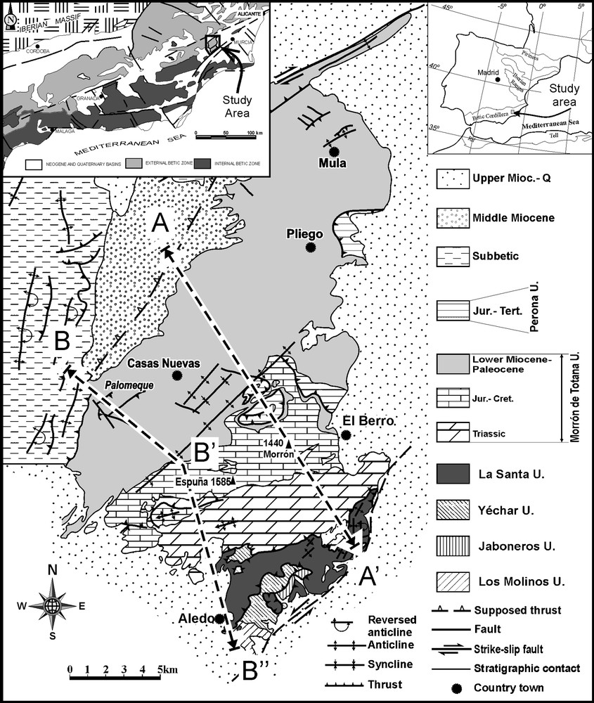
General situation and simplified geological map of the Espuña–Mula area. The position of the geological cross-sections of Fig. 2 is marked.
Fig. 1. Situation générale et carte géologique simplifiée de la zone d’Espuña–Mula. La position des coupes géologiques transversales de la Fig. 2 est indiquée.
In this work, our study of minor brittle and ductile–brittle structures formed in the contacts of the units leads us to propose a new structural evolution of the sector.
2 Geological framework of the Sierra Espuña
2.1 Main structural features
The earliest works on the general structure of the Sierra Espuña pointed out the superposition of the Malaguide over the Alpujarride [18,19]. Other authors have distinguished a varied number of tectonic units [8,9,17,22–24,26,28,32,35,36,38,45,46,51]. Sanz de Galdeano et al. [51] recognized five tectonic units, called (from bottom to top): Los Molinos, Jaboneros, Yéchar, La Santa, Morrón de Totana, and Perona (Fig. 1). The first is assigned to the Alpujarride Complex, the next three ones to the Intermediate Units, and the two highest to the Malaguide [40]. This division has been confirmed by mineralogical studies [1] as well as by later structural/stratigraphic ones [40], and thus will be used in the present work.
The kinematics of the contact between the units is open to discussion. Overthrusting towards the southeast has been described [31,45,46,51,52], as well as to the northwest [25,26,28,35,36,38–40]. Some authors have interpreted these surfaces as low-angle extensional faults, either with movement of the hanging wall block towards the ENE [28], or else as two distinct systems with movements towards the NNW and the west [8,9].
In addition to these features, it bears pointing out that palaeomagnetic studies performed in this zone have shown that the largest unit, that of Morrón de Totana, rotated some 180° [3,4] clockwise. This should be taken into account for kinematic reconstruction.
3 Main structures
The general structure of the area of the Sierra Espuña is a group of units tectonically stacked (Figs. 1 and 2) to form an antiformal stack, the top of which is the Morrón de Totana unit (the Perona unit occupies a higher position, but is a minor element within the general structure). In the study area, two zones are clearly differentiated: the southern zone, in which the lowest units crop out; and the northern zone, where only the upper units crop out.
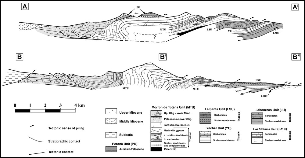
Geological cross-sections of the Sierra Espuña–Mula area. Their positions are marked in Fig. 1.
Fig. 2. Coupes géologiques transversales de la zone de la Sierra Espuña–Mula. Leurs positions sont indiquées sur la Fig. 1.
In the southern area, the superposition of the units is clearly distinguishable (Fig. 1) [41,51]. The basal contact of the Morrón de Totana Unit is marked by the presence of Palaeozoic grauwackes that outcrop at numerous points at the bottom of the unit. In addition, it is easy to trace the contact separating the La Santa unit from the immediately lower Yéchar Unit, as the detrital materials of the bottom of the former unit outcrop over the carbonates of the latter. Furthermore, the detrital materials of this latter unit present distinctive brown tones and a slight schistosity. Moreover, their colour differs from that of the detrital materials of the Jaboneros unit (violet shades in general) and from those of the Los Molinos unit (bluish–grey). This stack of units does not always completely crop out, so that in certain sectors, some units are absent (Figs. 1 and 2).
In the northern area, only the Morrón de Totana and Perona units crop out (Fig. 1). There the structure is dominated more by the presence of N-vergent folds (such as the Espuña Fold [20]) and of various tectonic sheets and blind thrusts [39] (Figs. 1 and 2). These structures can even affect Oligocene–Aquitanian materials.
In addition, on the northern border of the study area lies the contact between the Internal and External Zones (Fig. 1), affected by dextral faults with directions from N70E to east–west, parallel to the so-called Crevillente Fault [43]. On the western border, the External Betic Zone overthrusts the Morrón de Totana unit towards the east and the southeast (Fig. 1), a thrust sealed by Middle Miocene materials.
Finally, on the southeastern border, there is a large NNE–SSW sinistral strike-slip fault [27,51], affecting the Upper Miocene deposits (Fig. 1).
A gentle folding, with vertical axial planes, affects the entire tectonic build-up, being especially visible in the southern zone (Fig. 2).
4 Minor structures
The study of the minor structures was more systematic in the contact areas between the units. Faults, joints, lozenge-shaped bodies, fault propagation folds, drag folds, SC and pseudo-SC fabric, etc. were analysed. The results of this analysis are presented in Fig. 3.
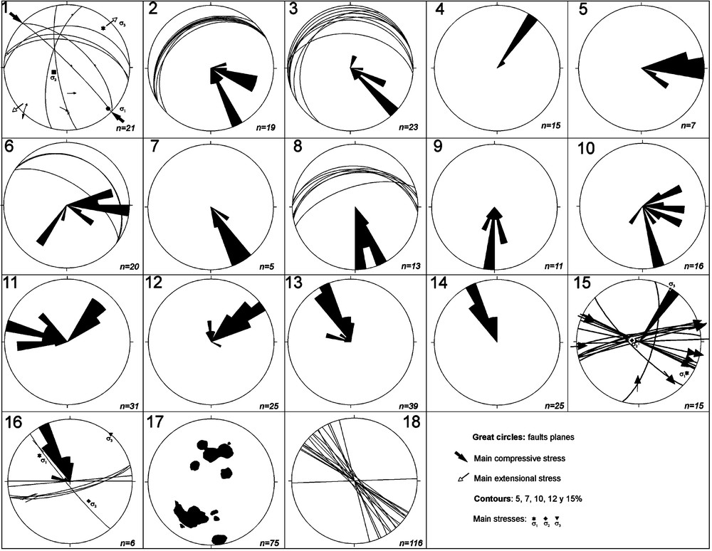
Rose diagrams showing the transport direction deduced from minor structures in the Sierra Espuña. Numbers correspond to measured stations (location in Fig. 4).
Fig.3. Diagrammes en rosaces indiquant les directions de transport déduites des structures secondaires de la Sierra Espuña. Les nombres correspondent aux stations relevées (situées sur la Fig. 4).
Diagrams 1 and 2 (Fig. 3) show data from the Los Molinos unit. In this zone, the deduced orientation of the stresses (Diagram 1) agrees with the direction of the displacement of the hanging wall block – towards the SSE (Figs. 3 and 4) – indicated by the lozenge-shaped bodies and the drag folds. Diagrams 3 and 4 were drawn in the Jaboneros unit (Fig. 4). In outcrop 3, the lozenge-shaped bodies, the pseudo-SC fabric, and the fault-propagating folds indicate a displacement direction towards the southeast. However, in the outcrop corresponding to Diagram 4, the direction deduced from the lozenge-shaped bodies is towards the northeast. With regard to the basal contact of the Yéchar unit (Diagram 5), the vergent drag folds and the presence of the centimetric sub-horizontal shear zones signify a top-to-the-east displacement direction (Figs. 3 and 4). Diagrams 6 to 9 correspond to the La Santa unit. In all these cases, the directions of displacement of the top blocks were deduced from the drag folds and pseudo-SC fabric (Fig. 5, Photos a and b). In the outcrop of Diagram 6, reverse faults (great circles of the diagram) are also recognized, these having a top-to-the-SSW transport direction; the rest of the kinematics indicators mark a transport direction towards the east. In the rest of the outcrops studied in this unit, the transport directions deduced for the hanging wall blocks are towards the SSE or the south. Locally, normal low-angle faults also appear, with a transport sense of the top block towards the southwest. At the basal contact of the Morrón de Totana unit (Diagram 10), the deduced transport directions appear dispersed (northeast to southwest), with a maximum concentrated around the SSE.

Tectonic map and directions of tectonic transport for the hanging wall deduced from minor structures. The positions of diagrams of Fig. 3 are indicated.
Fig. 4. Carte tectonique et directions de transport tectonique pour le compartiment chevauchant déduit de structures secondaires. Les positions des diagrammes de la Fig. 3 sont indiquées.

(a) Lozenge-shaped body indicating a southward displacement (La Santa unit). (b) Reverse fault showing southward vergence in Triassic sediments of La Santa unit. (c) North vergent decametric fold in the Morrón de Totana unit. (d) Minor vertical faults showing near-horizontal striae.
Fig. 5. (a) Corps en forme de losange indiquant un déplacement vers le sud (unité de la Santa). (b) Faille inverse montrant une vergence vers le sud dans les sédiments triasiques de l’unité de la Santa. (c) Pli décamétrique à vergence nord dans l’unité de Morrón de la Totana. (d) Failles verticales mineures montrant des stries presque horizontales.
Diagrams 11 to 16 correspond to the Morrón de Totana and Perona units (Fig. 4), where the displacement directions of the upper blocks vary between northeast (Diagrams 11 and 12) and northwest (Diagrams 11, 13, and 14). Similarly, in the sector of the Palomeque sheets, the direction deduced from the fault-propagation folds is towards the northeast (Fig. 5, photo c), whereas in the Mula sheets (Diagram 16), it is towards the northwest.
4.1 Other minor structures
In the Southeast of the Sierra Espuña, there are many faults with sinistral and normal components that affect the units studied, as well as the Upper Miocene materials. These are especially visible along the talus of the ‘Trasvase Tajo-Segura’ channel (Fig. 5, photo d); from the data presented by Lonergan and Schreiber [29] (Diagram 4 of their Fig. 5, p. 722), it is deduced that these faults have a direction of σ1 NNW–SSE. Finally, throughout the study area, a great number of joints are recognized, as well as normal high-angle faults that affect all the outcropping materials. Both types of structures present a great dispersion, though the predominant direction recognized is NW–SE (Diagrams 17 and 18).
5 Discussion
Here, we discuss the tectonic transport directions deduced from the above data and the structural stages that caused them (and their timing), in order to propose an evolutionary model for the Sierra Espuña area.
5.1 Interpretation of the deduced directions
The current superposition of the Alpujarride units corresponds to postmetamorphic events, as in most of the sectors of the cordillera, where rocks of higher metamorphic degree are situated above others of a lower degree [2,7,42,44]. Therefore, the present study focuses on post-metamorphic structures with brittle or brittle–ductile character. The only ductile structures that have been taken into account are folds that affect syn- or post-orogenic materials [35,37,38].
From the study of the minor structures, it is deduced that the lowest units of the Sierra Espuña present a southward displacement of the top blocks, though there is a dispersion in direction. On the contrary, in the upper units, the deduced directions have a northern component, except near Mula, where most of the structures present a displacement direction clearly linked to dextral strike-slip faults. The measurements made in the southeastern sector are consistent with the action of the sinistral strike-slip faults that outcrop in this zone; these faults also affect pre-existing structures, provoking their rotation, as occurs with the folds affecting metamorphic materials (Fig. 1), which have been rotated until they reached a north–south direction. The joints and high-angle normal faults existing throughout the study sector present a general NW–SE direction, which is compatible with the ENE–WSW extension recently recognized in the Internal Betic Zone [20].
Previous works refer to minor structures in the southern sector of the Sierra Espuña, indicating a tectonic transport direction with a northerly component [25,26], but none that we have found shows these transport directions. The southward transport directions have been interpreted as normal low-angle faults produced by an extensional phase [8,29]. Lonergan and Platt [28] stated that the contact between the Alpujarride and Malaguide in the Sierra Espuña is an extensional low-angle fault, based on the existence of a lack in the metamorphic degree. The metamorphism reached by the phyllites of the Alpujarride unit of Los Molinos is within the epizone [27]; in agreement with the data provided by Abad et al. [1], the overlying rocks have successively reached the anchizone (Yéchar unit), the late diagenesis zone (La Santa unit), and the early diagenesis zone (Morrón de Totana unit). Therefore, there is no lack of metamorphism as proposed by Lonergan and Platt [28]. These authors also stated that the total thickness of the outcropping materials in the Sierra Espuña would not be sufficient to produce the metamorphism observed at the base of the stack of units, which they interpreted as another indicator of the existence of an extension. However, as these same authors postulate, this feature may be due to other factors, for instance an anomalous geothermal gradient or a later extension (in fact, pointed out in the Sierra Espuña by [8,10]). Moreover, given the relationships existing between kinematic indicators with the reference surfaces of the stratigraphic series, it is deduced that the contacts between units are thrusts, as the hanging-wall block ascends in the series according to the direction of tectonic transport (Fig. 2). Nevertheless, at some points, top-to-the-west normal low-angle faults are visible, but we interpret these structures as being subsequent to the structuring of the units.
5.2 Structural stages
The above-mentioned opposing transport directions appear to indicate two phases of tectonic stacking, followed by other phases that would modify the pile of units, but it is not possible to establish the precise age of all of them. In agreement with data of previous authors [16,53,54] – especially with the findings of Martín-Martín [35], who analysed the Tertiary of the Morrón de Totana unit –, the thrusting of the Malaguide over the Alpujarride occurred in the Oligocene, as this thrust affects deposits from the Lower Oligocene. Thus, this is probably the age of the stacking of the lower Sierra Espuña units (although we cannot completely disregard that the structures studied in the lower units might have been caused by a later phase). Under the assumption that these structures were in fact linked to the superposition of units (now indicating a southward displacement), they would be previous to the possible rotation of the units related to the collision against the External Zones during the Lower Burdigalian, as the data presented by Allerton et al. [3,4] seem to indicate. These authors made a palaeomagnetic analysis of the Morrón de Totana unit with samples collected throughout the stratigraphic succession, from the Triassic to the Miocene materials in contact with the Subbetic, providing data that appear to indicate that the rotations affected the rest of the units in the Sierra Espuña. The structures observed in the upper units (indicating a top-to-the-north displacement direction) progressively affect rocks of the Oligocene and Aquitanian [39], and hence this stage must have taken place from the Lower Oligocene to the Aquitanian.
5.3 Evolutionary model
Taking into account the data presented, we propose the following evolutionary model for the Sierra Espuña. First of all, the northwards superposition of the lower units must have occurred in the Oligocene (Fig. 6, ii to v). Afterwards, in the Oligocene–Aquitanian, according to the youngest materials affected, the second thrust stage took place, the upper unit (Perona) being superposed southwards over the Morrón de Totana one and generating the related structures observed north of the Sierra Espuña (Fig. 6 vi to viii), as for example the Espuña fold [25]. During the Burdigalian, the westward displacement of the Internal Betic Zone [5,6,30,33,34,50] and collision against the External Zones probably caused the rotation of the units located all along the Internal–External Zone contact described throughout the Betic Cordillera and the Rif [11–13,47–49], and in particular in the area of the Sierra Espuña [3].
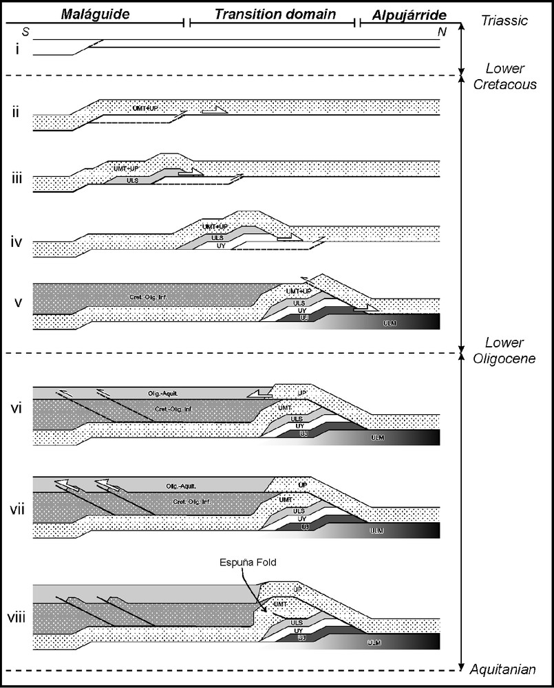
Schematic evolutionary model of the Sierra Espuña area. See text for explanation.
Fig. 6. Modèle schématique d’évolution de la zone de la Sierra Espuña. Voir texte pour davantage de détails.
At the end of the Burdigalian, an extensional phase occurred with a top-to-the-southwest displacement direction, which narrowed the stack of units already structured [10]. This stage could have been responsible for the western displacement locally recognized in the southern sector of the Sierra Espuña. From this time until the Upper Miocene, the main deformations in the area of the Sierra Espuña corresponded to the segments of the Crevillente Fault, which outcropped near Mula, affecting not only the units of the Internal zone, but also the External Zones. Finally, in the Upper Miocene, the normal and sinistral strike-slip faults acted, causing the arching of the pre-existing structures. From this time on, the area was lifted, as a result of a gentle antiformal fold.
From the reconstruction of the deformation stages made and from the rotation undergone by this area [3], we deduce that the structures indicating southward displacements in the lower units of the Sierra Espuña originally had a northwards sense. From a palaeogeographic standpoint, this signifies that the Alpujarride (here represented by the Los Molinos unit) was situated to the north of the Malaguide (represented by the units of La Santa, Morrón de Totana, and Perona), with the Intermediate Units (Jaboneros and Yéchar) between the two. This reconstruction agrees with the palaeogeographic models generally accepted for the Betic Cordillera [15,19,55] (Fig. 6).
6 Conclusions
The detailed analysis of the brittle and brittle–ductile structures of the area of the Sierra Espuña carried out in this work reveals two superposition stages of units with opposing directions. The first stage gave rise to the stacking of the lower units, this taking place in the Oligocene, when the Malaguide Complex overthrusted the Alpujarride and the Intermediate Units. The second stage of the stacking occurred from the Middle Oligocene–Aquitanian and gave rise to break of the Malaguide slice – that is, to the overthrusting of the uppermost unit (Perona) outcropping in the northern sector of the study area.
In the Burdigalian, the Internal Betic Zone collided obliquely against the External Zones, probably rotating the previously structured units by around 180°. Thus, after the rotations, the movements that were originally northwards shift towards the south. From this time on, an extensional phase took place with transport directions to the west, followed by a phase characterized by the activity of the Crevillente Fault. Finally, the action of a major sinistral fault dragged part of the structures of the southeastern border of the Sierra Espuña. This reconstruction of movements, here presented for the first time, shows that the Malaguide Complex is situated to the south of the Alpujarride, confirming the hypothesis postulated by many previous palaeogeographic reconstructions.
Acknowledgements
This research was financed by the projects BTE2003-01113, CGL2005-03887 and CGL2006–08848 of the ‘Ministerio de Educación y Ciencia’, by the Research Group RNM-127 of the Junta de Andalucía, and by the ‘Grupos y Proyectos de Investigación de la Generalitat Valenciana del Departamento de Ciencias de la Tierra’ of the University of Alicante (Spain). We appreciate the comments and revisions of Professor M. Durand Delga and an anonymous referee, who significantly improved our manuscript. We also thank David Nesbitt for the revision of the English.