

1 Introduction
In Tibet, the Indosinian orogeny corresponds to the closure, in the Late Triassic–Early Jurassic, of the Palaeotethys ocean between the South China, North China and Qiangtang (North Tibet) blocks [30,42,47]. The Triassic belt (with an area of more than 300,000 km2), represents a key area for understanding the tectonic evolution of the Eurasian plate and the Tibetan Plateau. Recent studies in Songpan–Garzê and on the Kunlun and Jinsha sutures to the west have provided geochronological data on tectonics, metamorphic and magmatic events linked to orogeny (Table 1, Fig. 1). However, these studies are spread over the whole area and none of them provides an integrative model for the Indosinian orogeny in North Tibet. In this paper, we compile all the data available and integrate them with field observations obtained during seven field expeditions between 1990 and 2000 to build up a first large-scale comprehensive model of the kinematic evolution of the belt.
Previous geochronological data in the study area. Numbers refer to the geochronological data plotted on the map (Figs. 1 and 2). Z: zircon, mz: monazite, bt: biotite, mus: muscovite, W.M.: white micas, Hb hornblende, K-feld: K-feldspar, gt: garnet
Tableau 1 Tableau récapitulatif des données géochronologiques. Les numéros font référence aux données géochronologiques localisées sur les cartes (Figs. 1 et 2). Z : zircon, mz : monazite, bt : biotite, mus : muscovite, W.M. : micas blancs, Hb : hornblende, K-feld : feldspath potassique, gt : grenat
| Area | No. – Location | Lithology | Method | Age (Ma, ± 2σ) | Reference |
| Kunlun | 1 – Jinshuikou | Granitic gneiss | Ar/Ar (bt, mus) | 212–242 | [26] |
| 2 – Golmud | granite | U/Pb (Z) | 240 ± 6 | [15] | |
| Ar/Ar (bt) | 252 ± 5 | [32] | |||
| (K-feld) | 219–223 | ||||
| 3 – Xidatan | Deformed pegmatite | Rb/Sr (mus) | 192 ± 12 | [4] | |
| Mylonitic gneiss | 197 ± 3 | ||||
| 4 – Kokoxili | granitoids | U/Pb (Z) | 217 ± 10 | [38] | |
| 207 ± 3 | |||||
| 5 – Kudi | Tianshuihai granite | Ar/Ar (mus) | 190 ± 8 | [31] | |
| Qiangtang | 6 – Gangma Co | Blueschist | Ar/Ar (W. M) | 223 ± 4 | [29] |
| (Hb) | 222.8 ± 0.8 | [25] | |||
| 205 ± 0.3 | |||||
| 7 – Yushu | Granite | U/Pb (Z) | 206 ± 7 | [38] | |
| Orthogneiss | U/Pb (Z) | 204 ± 1 | |||
| Paragneiss | U/Pb (mz) | 244 ± 4 | |||
| Yidun | 8 – Litang–Batang | Calc-alkalic granites | U/Pb (Z) | 245–229 | [36] |
| 219–216 | |||||
| Songpan | 9 – | Tagong granite | U/Pb (Z) | 224 ± 8 | [46] |
| Riluku granite | U/Pb (Z) | 219–228 | |||
| 10 – Danba | H T°C-medium P metamorphism | Th/Pb (mz) | 194 ± 3 | [18] | |
| Sm/Nd (gt) | 204–187 | ||||
| 11 – | Manai granite | U/Pb (Z) | 197 ± 6 | [39] | |
| Rilonguan granite | U/Pb (Z) | 195 ± 6 | |||
| Markam granite | U/Pb (Z) | 188 ± 1 | |||
| Yanggon granite | U/Pb (Z) | 221 ± 4 | [54] | ||
| Maoergai granite | U/Pb (Z) | 216 ± 6 |
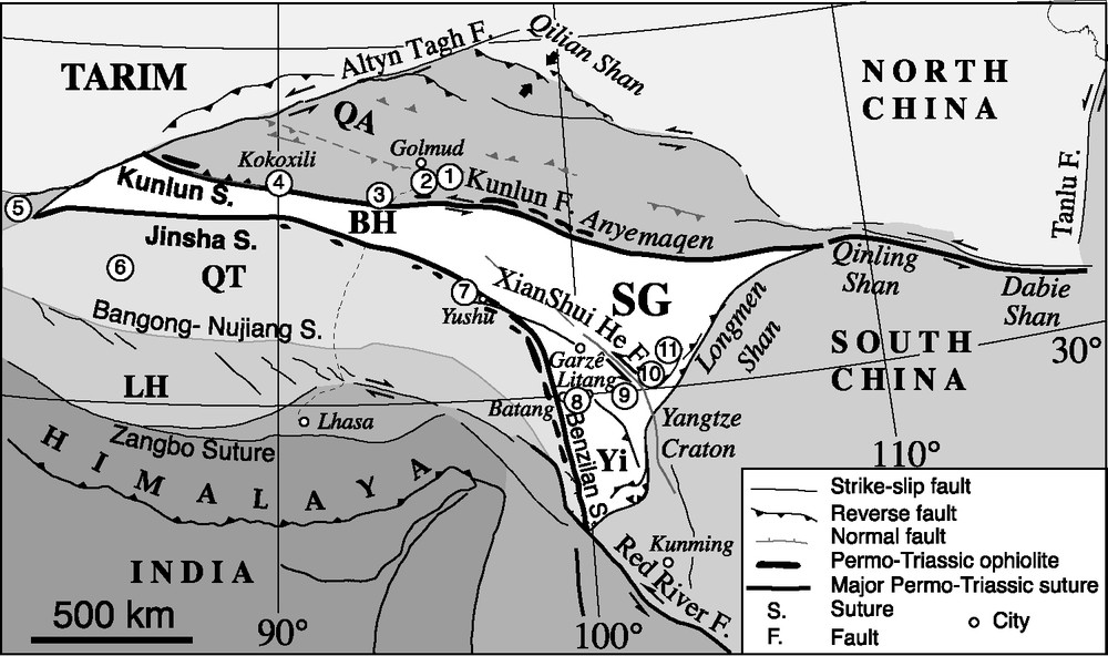
Simplified structural map of Tibet. The white area represents the current extension of the Triassic belt. SG: Songpan–Garzê belt; BH: Bayan Har; Yi: Yidun (or Litang–Batang) block; LH: Lhasa block; QT: Qiangtang block; QA: Qaidam block. Numbers refer to the geochronological data presented in Table 1.
Fig. 1. Schéma structural simplifié du plateau tibétain. La zone blanche représente l’étendue actuelle de la chaîne triasique. SG : chaîne de Songpan–Garzê ; BH : Bayan Har ; Yi : bloc de Yidun (ou de Litang–Batang) ; LH : bloc de Lhassa ; QT : bloc du Qiangtang ; QA : bloc du Qaidam. Les numéros font référence aux données géochronologiques présentées dans le Tableau 1.
2 Regional geology, tectonic setting and geochronological data
The Triassic fold belt of North Tibet is mainly composed, from west to east, by the Bayan Har terranes, Songpan–Garzê, and Yidun (Litang-Batang) blocks. It is bounded by the North China, South China, and North Tibet (Qiangtang) continental blocks (Fig. 1). To the east, the Tertiary Longmen–Shan thrust belt separates the widest part of the Triassic domain from the Sichuan basin [7,8,51,52] (Figs. 1 and 2).

Geological map of the south-east edge of the Songpan–Garzê belt (modified after [39]). See Table 1 and the text for details on the geochronological data.
Fig. 2. Carte géologique de la bordure sud-est de la chaîne de Songpan–Garzê (modifiée d’après [39]). Voir le Tableau 1 et le texte pour les détails concernant les données géochronologiques.
2.1 Triassic subduction zones and sutures
The northern limit of the Triassic belt is formed by the Kunlun and Anyemaqen suture zones outlined by ophiolites (Fig. 1) that join the Qinling Shan and Dabie Shan belts to the east (e.g., [38]). These suture zones result from the closure of the Palaeotethys ocean during the Late Palaeozoic, associated with a north-dipping subduction [22,48,50]. East of Golmud (Fig. 1), a granodiorite from the Kunlun batholith indicates ongoing subduction in this area since the Early Triassic (U/Pb age of 240 ± 6 Ma obtained by Harris et al. [15]). More to the west, near Kokoxili, U/Pb ages on calc-alkaline granitoids (217 ± 10 and 207 ± 3 Ma) show that this zone was still active in the Late Triassic [38] (Table 1, Fig. 1). Moreover, a few complementary data from the Golmud batholith suggest that the subduction has resumed in the Early Jurassic [15].
The Jinsha suture zone bounds the Triassic domain to the south. It has been considered as resulting from a Late Palaeozoic subduction zone dipping either to the west [20,41,44], or to the east [6,35]. However, most recent studies on granite and blueschist occurrences within the Qiangtang block strongly suggest that the Jinsha subduction was dipping westward [20,25,38,44]. Blueschist outcrops are dated between 223 ± 4 and 205 ± 0.3 Ma (39Ar/40Ar) (Fig. 1 and Table 1) [20,25]. Near the Yushu city, calc-alkaline granite and orthogneiss immediately south of the ophiolite belt are 206 ± 7 Ma and 204 ± 1 Ma old respectively [38], confirming the Triassic west-dipping subduction. Roger et al. [38] proposed that the Jinsha and Kunlun-Anyemaqen subduction zones were acting synchronously, and with opposite polarities. The Jinsha suture zone continues towards the southeast through the Benzilan suture (Fig. 1) (e.g., [38]).
East of the Jinsha suture zone, the Litang–Batang arc domain (so-called Yidun arc) presents numerous calc-alkaline granites and arc-type rhyolites dated from 245 to 216 Ma (U/Pb zircon) (Fig. 1 and Table 1). The Hf isotope signature of these calc-alkaline magmas suggests an affinity with the Mesoproterozoic material of the Yangtze craton (northern side of the South China block) [36].
East of the Litang-Batang domain, the Triassic fold belt overthrusts the continental margin of the South China Block (Fig. 1) [6,7,30,45].
2.2 The Triassic fold and thrust belt
We summarize the main characters of the Bayan Har and Songpan–Garzê domains, which both constitute the Triassic fold and thrust belt of North Tibet. The most studied, the Songpan–Garzê belt, was mainly formed by shortening of a wide oceanic basin [47] filled with a thick (5 to 15 km) sequence of Triassic flyschoid sediments coming from surrounding reliefs and probably deposited as large submarine fan deltas. They were deposited both on the oceanic crust of the basin and on the surrounding thinned continental margins [30,33,34,41,56]. On the South China block, the Triassic series unconformably overlay the thick Palaeozoic cover of the Yangtze craton that itself lies on Upper Proterozoic (Sinian) sediments. The Sinian in turn unconformably overlies the old basement of the craton (Fig. 2), which has been dated back to 0.8 to 1 Ga by U/Pb on zircon (the Kanding complex and the Bikou group) [13,27,37,49,55]. In the Songpan–Garzê belt, the Triassic series are intensively folded and faulted. They are separated from the crystalline basement outcropping near the Danba city by a large-scale ductile décollement zone affecting the Palaeozoic–Triassic interface [6,16,28,39] (Fig. 2). This basement shares many similarities with the basement of the Yangtze craton outcropping farther south [37]. More to the north and to the northwest, below the thickened Triassic series, the present-day composition (oceanic or continental) of the basement remains unknown.
The décollement has been recognized over more than 300 km and studied in detail in the Tien Wan (southwest of Konga Shan) and Danba areas [6,16,30,47] (Fig. 2). Close to Danba, a high-temperature/medium-pressure metamorphism is associated with deformation (garnet–sillimanite–kyanite, with P–T conditions estimated at 5–7 kbar and 400–600 °C). It has been dated between 204 and 190 Ma [18,47] (Figs. 1 and 2 and Table 1). These results suggest that the Triassic series have been largely thickened by folding (thickness ∼20 km) induced by horizontal shortening above the décollement [6,30]. Late orogenic granitic plutons have been dated in this area. An U/Pb age of 197 ± 6 Ma on the synkinematic Manai granite and U/Pb ages of 195 ± 6 Ma and 188 ± 1 Ma on the post-orogenic Rilonguan and Markam granites have been obtained [39] (Figs. 1 and 2 and Table 1). Further north, the Yanggon and Maoergai granitoids present U/Pb (SHRIMP) ages of 221 ± 4 Ma and 216 ± 6 Ma, respectively [54], which are significantly older than the ages of the metamorphism and granites obtained 50 to 100 km further south-southwest (Fig. 2, Table 1). The isotopic composition (Nd, Sr, Pb) of most of these granitoids shows that their magma source was predominantly derived from the melting of the Songpan–Garzê Proterozoic basement (Yangtze block) with varying degrees of sedimentary material (possibly Triassic sediment) and negligible mantle source contribution [39,54].
The Bayan Har domain is poorly studied (Fig. 1). In the elongated area comprised between the Jinsha and Kunlun suture zones, the Triassic sedimentary sequences have been strongly folded and faulted during the closure of the Palaeotethys, which separated the Qiantang and Qaidam continental blocks. Intense shortening induced the growth of wide accretionary wedges. The deformation is characterized by décollement and folding of the thick flyschoid series deposited along the margins of the continental domains. It seems to have developed in conditions similar to that described in the Songpan–Garzê domain.
3 Geodynamic evolution
3.1 Permian
Due to the opening of the Neotethys, the Qiangtang block, which was part of the Cimmerian continent detached from the Gondwana, migrated towards the north (in the present reference frame), closing the Palaeotethys. The South China block that rifted from Gondwana in Devonian times moved toward the North China block. Palaeomagnetic and geochronological data show that the collision occurred diachronously from east to west, with a major rotation near the Triassic–Jurassic boundary [11]. In the Qinling belt, a continental subduction event is marked by Late Triassic high-pressure metamorphism [1,2,10,14,40].
Around the Palaeotethys, the Permian sedimentation is mainly characterized by platform-type carbonates (e.g., [13]). The eastern domain of the Palaeotethys presents a more complex setting. Two main basins can be defined. A first one developed to the east due to differential motion between the North China block and the South China block (Songpan–Garzê basin) [54]. A second basin (Garzê–Litang basin) was formed by a rifting event that separated the Litang–Batang block from the South China continent (Figs. 3 and 4). It was probably connected to the Panxi Rift recognised further south, about 100 km north of Kunming and dated around 260–250 Ma (Emei Shan basalts) [43,53–55] (Fig. 1).

Geodynamic evolution of the North Tibet from the Permian to the Early Jurassic. The deformation associated with the Triassic belts is suggested. Dark green dotted lines show the locations and names of future subduction zones. Green area shows the Palaeotethysian domain and its northern branches (light green). The dotted area shows the domains of Triassic high sedimentary input. Yi: Yidun (or Litang-Batang) block; IN: Indochina block; QT: Qiangtang block; QA: Qaidam block; NC: North China block; SC: South China block. AB; CD; EF and GH location of evolutionary sections of Fig. 4A–D.
Fig. 3. Évolution géodynamique du Nord-Tibet, du Permien au Jurassique inférieur. La déformation associée aux chaînes triasiques est suggérée. Les lignes en vert foncé en pointillé montrent la localisation et le nom des futures zones de subduction. La zone en vert montre le domaine de la Paléotéthys et ses branches nord (en vert clair). Yi : bloc de Yidun (ou de Litang–Batang) ; IN : bloc Indochine ; QT : bloc Qiangtang ; QA : bloc Qaidam ; NC : bloc Chine du Nord ; SC : bloc Chine du Sud. AB, CD, EF et GH, localisation des coupes évolutives de la Fig. 4A–D.

Synthetic cross-sections showing the tectonic evolution of the Triassic belt from the Permian to the Early Jurassic. (A) Transect AB. The northward motion of Qiangtang induces the closure of the Palaeotethys and the development of the Yushu volcanic arc. Shortening of the northeastern branch of the Palaeotethys along the north-dipping Anyemaquen subduction. A thick accretionary wedge develops against the NC margin. End of subductions: remnants of the Palaeotethys (Jinsha suture) and of the intra-oceanic Yushu arc are thrust on the Qiangtang continental margin. To the north, remnants of the northern oceanic basin (Anyemaquen suture) separate NC from the thick and wide Triassic orogenic wedge. (B) Transect CD. Situation before shortening showing the thinned margin of the South China block. Continental subduction and growth of the Qinling décollement–fold and thrust belt. (C) Transect EF. Situation before convergence. The closure of the Palaeotethys induces the development of Kunlun Arc and accretionary wedge along the Qaidam block. The Jinsha subduction develops to the south. Convergence resumes. A wide and thick Triassic orogenic wedge separates the two main continental blocks. Remnants of the oceanic domain crop along the Jinsha suture to the south and along the Kunlun suture to the north. (D) Transect GH. The subduction of the Palaeotethys induces the development of the Litang–Batang volcanic arc and of the associated back-arc basin to the east. The arc develops on a rifted continental piece of South China. The closure of the oceanic domain and of the marginal basin allows the growth of Triassic accretionary wedges. After the convergence, a complex domain separates Qiantang from South China. From west to east: Jinsha suture, strongly shortened Triassic sedimentary wedge, remnants of the Batang–Litang arc domain and suture, doubly vergent Triassic sedimentary wedge associated with the closure of the Litang back arc-basin.
Fig. 4. Coupes synthétiques montrant l’évolution tectonique de la chaîne triasique, depuis le Permien jusqu’au Jurassique inférieur. (A) Transect AB. Fermeture de la Paléotéthys et mise en place de l’arc volcanique de Yushu, provoquées par la remontée vers le nord du bloc de Qiangtang. Raccourcissement de la branche nord-est de la Paléotéthys le long de la subduction à vergence nord d’Anyenaqen. Un important prisme d’accrétion se développe sur la marge du bloc Chine du Nord. Arrêt des zones de subduction : le reliquat de la Paléotéthys et de l’arc intra-océanique de Yushu chevauche la marge continentale du bloc Qiangtang. Au nord, le bloc Chine du Nord et le vaste prisme orogénique triasique sont séparés par le reliquat nord d’un bassin océanique (suture d’Anyemaqen). (B) Transect CD. La situation avant le raccourcissement montre une marge amincie pour le bloc Chine du Sud. Subduction continentale et croissance de la chaîne des Qinling de type plissement–décollement. (C) Transect EF. Situation avant la convergence. La fermeture de la Paléotéthys induit le développement de l’arc du Kunlun et du prisme d’accrétion le long du bloc Qaidam. Au sud, la zone de subduction de Jinsha se met en place. La convergence reprend. Un vaste et épais prisme orogénique triasique sépare les deux principaux blocs continentaux. Les reliquats du domaine océanique affleurent au sud le long de la suture de Jinsha et au nord le long de la suture du Kunlun. (D) Transect GH. La subduction de la Paléotéthys provoque le développement de l’arc volcanique de Litang–Batang et du bassin d’arrière-arc associé, à l’est. L’arc se développe sur la marge continentale en extension du bloc Chine du Sud. La fermeture du domaine océanique et du bassin marginal permet la croissance du prisme d’accrétion triasique. Après la convergence, un domaine complexe sépare les blocs du Qiangtang et de Chine du Sud. D’ouest en est, on observe : la suture de Jinsha, le prisme d’accrétion triasique fortement raccourci, les reliquats de l’arc de Litang–Batang et de la suture, ainsi que la double vergence du prisme d’accrétion triasique associé avec la fermeture du bassin d’arrière arc de Litang.
3.2 Early to Middle Triassic
The Kunlun-Anyemaqen and Jinsha subduction zones were active since Late Permian–Early Triassic times with an opposite vergence (Figs. 3 et 4). This is constrained by the 245-Ma-old Golmud granite emplacement in the Kunlun block (Fig. 1 and Table 1) [15,38] and along the Jinsha suture zone, by the occurrence of an Early–Middle Triassic metamorphic event [38]. The 244 ± 4 Ma age of paragneiss (U/Pb monazite) [38] in the northeastern Qiangtang block (near the Yushu city) (Fig. 1) suggests that the Early Triassic deformation, only observed in the western Yidun arc, was also present along the southwestern boundary of the Palaeotethys. To account for the first calc-alkaline magmatic episode (245–229 Ma) observed in the western Yidun arc, Reid et al. [35,36] proposed a west-verging subduction of the Garzê–Litang ocean under the Yidun block (Figs. 1 et 3). However, this hypothesis would imply that the Garzê–Litang basin was wide enough to account for a long-lasting subduction in order to generate the large volume of arc-granite observed. From different observations, we favour a different hypothesis. East of the Yidun block, the few ophiolitic remnants observed along the large Garzê pluton [36] are not exposed southeast of the Litang city. Even considering the strong Tertiary deformation, the Triassic granites are too close to the Garzê–Litang ophiolitic suture to characterize an arc generated by such a westward-dipping subduction zone. We propose that the Garzê–Litang ocean was only a small marginal basin developed in a back-arc setting (following the Permian rifting event) which separated the Yidun (or Batang–Litang) block from the South China–Indochina craton. The east-dipping subduction zone (Yushu–Batang) that generated the Yidun granites was thus located west of the Batang–Litang block (Figs. 3 et 4). This subduction, together with the Jinsha subduction zone further west, accommodated the closure of the large Palaeotethys ocean. More to the northwest, the Yushu–Batang subduction becomes intra-oceanic and joins the Kunlun-Anyemaqen subduction zone to the north. The subsequent arc-type volcanism forms the intra-oceanic Yushu arc.
Along the northern and western borders of the South China block, the Songpan–Garzê–Litang basin is limited by a passive margin [6,30,39,54]. The sedimentation in these basins is characterized by thick detrital flyschoid series (large fluvial fans) that will constitute the large volumes of Triassic materials involved in the Indosinian fold belt. In the Middle Triassic, these sediments are essentially produced by the erosion of former Palaeozoic belts located along the southern part of the North China block [33] (derived from 1.8–2-Ga and 2.4–2.6-Ga exhumed Proterozoic rocks [5].
3.3 Late Triassic–Lower Jurassic
The Kunlun–Anyemaqen–Qinling subduction zone induced the widespread emplacement of large batholiths (220–200 Ma) [15,38] and controlled the development of the Kunlun and Qinling orogenic wedges (Fig. 1 and Table 1). South of the Palaeotethys, deformation along the Jinsha subduction is attested to by HP–LT blueschist metamorphism (220 Ma [20]). 210–200-Ma-old calc-alkalic granites [38] were emplaced in the complex orogenic wedge bounding the northern edge of the Qiangtang block (Fig. 1 and Table 1). Their origin is not clear; they could be attributed either to the Jinsha subduction or to the Yushu–Batang subduction (Figs. 3 and 4). To the southeast, along the eastern margin of the Batang–Litang block, a second series of calc-alkalic granites (219–216 Ma) was emplaced in the Late Triassic flysch-type sediments and volcanites [36] (Fig. 1 and Table 1). Like the first one, this second magmatic event is attributed to the east-verging Yushu–Batang subduction (Figs. 3 and 4).
In the Songpan–Garzê basin, U/Pb dating of detrital zircons from Late Triassic sandstones indicates that the main source of sediments was located in the Yangtze craton [5]. This change from a Middle Triassic source area in the North China block to a Late Triassic source in the Yangtze craton is probably linked to the growth of the Qinling range that formed a barrier to sediments coming from the north, favouring sediment flux from the south.
Subduction under the North China block induces the closure of the Songpan–Garzê ocean and the development of the wide Triassic accretionary wedge. Then, the wedge overthrusts the South China block margin along a large décollement level affecting the Palaeozoic sedimentary sequence (Silurian–Devonian) [6,39]. In the internal domain of the orogenic wedge, the deformation is associated with a Barrovian-type metamorphism (HT/MP) dated back to 220–190 Ma [18,47] (Figs. 1, 2 and Table 1). The southward vergent décollement zone can be followed on thousands of kilometres from the north, in the Dabie Shan and Qinling mountains, to the south, in the Konga Shan area [6,17,30,39].
In the Bayan Har area, the Triassic deformation is very similar to the one observed in the eastern domain. It is characterized by an intense folding and thickening of the Triassic sequences, resulting in a complex doubly vergent accretionary wedge (Figs. 1 and 4).
Thus, the Triassic orogeny involves important shortening and subsequent crustal thickening of the orogenic wedge [6,28]. Zhang et al. [54] estimated the thickness of the crust to have been locally over 50 km in the Songpan area. Such crustal thickening induced the emplacement of syn- to late-orogenic granites (220–200 Ma) [39,54], as well as post-orogenic granites (200–188 Ma) [39] (Figs. 1, 2 and 4 and Table 1). The slowdown of the main Indosinian tectonic activity is marked by slightly folded Late Triassic continental sediments laying unconformably on the top of the intensely folded Middle Triassic marine formations (Malavieille & Roger, personal observations) [6].
4 Discussion and conclusion
The singularity of the Triassic belts of North Tibet relies on the huge volumes of Triassic sediments deposited in the Palaeotethys and surrounding subsidiary basins. Such a build-up of wide accretionary orogens is exceptional and can be attributed to the high initial thickness of the Triassic series, leading to the development of large-scale décollements, intense folding, subduction-related large shortening, and crustal thickening. The peculiar tectonic and geodynamic setting did not allow a complete collision between the main continental domains. Homogeneous thickening of the sedimentary series throughout the range was not followed by significant Mesozoic exhumation, classically occurring in the internal domains of most collision belts, suggesting that the continental collision stage was not reached [30,39]. In this part of Tibet, most of the exhumation occurred after ca. 30 Ma as a response to the India–Asia collision [3,18,19,21,32,39].
The relationships between the Triassic belts of North Tibet and the classical Indosinian belt of Indochina must be clarified. Indeed, the Indosinian orogeny that has been defined first in Indochina [9,12] is characterized by localized deformations attributed there to major strike-slip faults. This tectonic period is marked by an Early Triassic metamorphic event (250 to 240 Ma), whose end is dated by the Norian unconformity [23,24]. On the opposite, in North Tibet, the same period was marked by the onset of the Palaeotethys closure along the Jinsha, Yushu–Batang and Kunlun-Anyemaqen subduction zones. Thus, in the accretionary orogens of North Tibet, the deformation was different, younger and distributed on wide domains. For example, the ages of the metamorphism and the emplacement of the granites in the Songpan area are significantly younger (220–200 Ma) [18,39,54]. The link between the Indochinese and Tibetan belts still remains to be analysed. Are these two very different deformation patterns generated during the same orogenic phase or are there two distinct belts formed during two different tectonic phases?
Acknowledgements
The authors would like to thank all the colleagues involved in the field expeditions realized between 1990 and 2000, particularly the leaders: Z.Q. Xu, P. Tapponnier, and M. Mattauer. Most of these studies were supported by INSU–CNRS funding.