

1 Introduction
The weather was glorious in Lisbon on Saturday, 1 November 1755. The capital of Portugal (235,000 to 270,000 inhabitants at the time) owed its prosperity to an extensive colonial empire. The people were attending the services of All Hallows, when the area underwent the strongest earthquake ever recorded on the western coasts of Europe. The collapse of churches wiped out a number of lives. Some people, trying to escape the fall of debris and the fire (lit by houses collapsing on their kitchen hearth), or hoping to flee by sea, took refuge on the quays of the harbour: but a tsunami, 5 to 10 m high according to coeval accounts [2], struck the lower town and the coasts from Coruña to Morocco.
In Lisbon alone, casualties’ estimates range from 15,000 to 60,000, the moderate number being more likely. The earthquake and tsunami each caused the loss of about 1000 people, much less than the fire, which raged for one week.1
Lisbon was not the only town to be struck, but is everywhere referred to as the most hard-hit, due to its size and to the superimposition of three concurrent mechanisms to the disaster.
On the contrary, the Spanish harbour-town of Cadiz was considered as miraculously saved: “The sea flood raised fears that the town might be submerged […] The waters threw down the parapet of the battlement on the West side […] There happened to flow about 3 or 4 feet of water in the houses of the small flooded area. Two women and three children were drowned there. That is all the harm done to the town by the sea…” [2].
Most victims were travellers washed away from the coastal road, on the sandbar joining the town to the mainland. The number remained rather moderate, as the Governor had ordered the town gates to be closed.
2 Present state of scientific assessment of the earthquake and tsunami
Historical and scientific studies on the great Lisbon earthquake never ended ever since. The sustained compilation and analysis of data made it possible to assign a Moment Magnitude of 8.7 [13,17] and a MSK intensity of XI to XII [17,20,22].
Numerous authors tried to find out the tectonic origin of the Lisbon earthquake, either using macroseismic data [18,20] or data on the amplitude of the tsunami [1]. For a long time, the assumption was accepted that the seismic source was located south of the Gorringe Bank, in the Horseshoe abyssal plain, in a tectonic context defined by the earthquake of 28 February 1969. Much weaker than that of 1755, this earthquake was infinitely better observed, instrumentally speaking.
From 1996 on, Portuguese researchers have tried to locate the source, or to reconfirm its position, by modelling the Tsunami. This approach requires a thorough compilation of the tsunami parameters [4].
In the first modelling attempt [3], the ‘same as 1969’ assumption was also accepted. However, the conclusion was that the Gorringe Bank source was located too far to the west and to the south for a good simulation of the tsunami parameters. The authors had to assume a double source, made of two compressive faults, south and west of Cape São Vicente [3,4], closer to the cape than the epicentre of the 1969 earthquake.
This assumption was questioned again when Zitellini et al. [26] identified a compressive fault, about a hundred kilometres to the southwest of Cape São Vicente, which they called the Marquès de Pombal thrust. This structure appeared as a good candidate to the responsibility for the 1755 earthquake; it also appeared to fit as the source that modelling had induced Baptista et al. [3] to suspect.
The modelling of a tsunami caused by such a source [6] met with the same difficulty, an impossibility to reproduce some classical data on the 1755 event. From 1996 on, in following publications, the authors reached similar conclusions: “The most important discrepancy found in wave heights was the value reported for Cadiz […] suggesting that either the historical data were overestimated or that the local run-up effects are dominant” [5].
The arrival time of the first wave is not easily reproduced either. According to historical data [4], the arrival time at Cadiz was 78 min: the various modelling attempts have difficulties to reach three-quarters of an hour, hardly more than half this reported time-span.
The lack of a consensus on the structure of the Azores–Gibraltar transform fault, Betic and Rifian chains, and Alboran Sea, led the modellers to explore successively each mechanism suggested for the 1755 earthquake, as new theories were formulated.
The most recent interpretation of the structure of this tectonic domain, devised by Gutscher [14–16,23], implies the subduction of the Atlantic part of the African plate below the Gibraltar Arc. Modelling the tsunami of 1755 from a seismic source constituted of a shallow sliding plane dipping to the east [16], in accordance with this new tectonic outline of the Arc of Gibraltar, yields rather better results than the multiple sources used in the previous modelling experiments. The violence of the earthquake of 1755, stronger in Portugal, and the arrival time of the tsunami to the coasts lead to place its origin on the external rim of the accretion prism.
3 Documentary sources used in this study
Baptista et al. [4], compiling data to constrain their model, ranked various documents according to their subject (earthquake vs. tsunami) and assigned them a reliability index from 1 to 3. These data, assembled as tables, dealt with the time and duration of the earthquake, the tsunami travel time, the direction of the first movement (up or down), the height of the tsunami waves, the number and period of the characterized waves, the duration of the water disturbance. Unfortunately, the study remained statistical only: the references to the documents and data provided in the tables were not included, and the historical database was not made available.
The conclusions of the joint article on the modelling [5] appeared to call again for a questioning of the classical data: this remained without pursuit, for want of original documents to renew the analysis.
Our critical analysis of a restricted selection of historical documents, recorded in archives and libraries, focuses on the height reached by the tsunami in Cadiz, the main factor for which the models fail to account.
- • The current estimate of the 15-m height of the tsunami wave at Cadiz originates from letters read at the meeting of the Royal Society of London on 18 December 1755, seven weeks after the earthquake. The first one [7] was written by a British merchant, Benjamin Bewick, on 4 November 1755. The second one [24] comes from no less than Antonio de Ulloa, an officer in the Spanish Navy and correspondent to several official Academies in Europe. They were immediately published.
Actually, their estimate is vastly superior: both mention the height of 60 feet, without specifying whether they mean the Spanish pié (0.279 m: the event occurred in Spain), or the British Foot (0.305 m: the letters appear in a British journal), or the French pied de roy (0.325 m, one-sixth of the toise du Pérou): the French units had an outstanding position in scientific circles since the expeditions to Peru and to Lapland by the French Royal Academy of Sciences of Paris, in order to provide a better measurement of the meridian. A Spanish member of the expedition to Peru, Antonio de Ulloa, was familiar with the French units, and mentions twice the word toise, implying their use. Thus, the wave would have been 19.5 m high. Later, the pied de roy being abandoned, the understanding drifted to the imperial foot and the estimate was taken as 18.3 m.
- • A lesser-known article published in the Acts of the Royal Academy of Sciences of Sweden [25] may allow some cross reading of the data supplied under Ulloa's name.
The French documents referred to here are very early ones, almost neglected for two centuries and a half, for want of proper publication or due to their restricted status as diplomatic mail.
- • A letter dated 4 November 1755 [9] was sent by the French Consul in Cadiz to a M. Partyet, French Consul General in Madrid. The author of the letter, a M. Desvarennes, is named in another letter by Partyet to the State Secretary to Maritime Affairs, dated 10 November 1755, to which the Cadiz letter was joined (both in the ‘Archives nationales de France’, fond Marine B7/396). Not a scientific document, it is a testimony of what a well-bred man did feel, observe, or gather. Part of its interest is a confirmation of the local public knowledge, as early as 4 November, of a work of scientific observation on the earthquake and tsunami, done by L. Godin.
- • A second one [11], kept in the handwritten Proceedings of the Royal Academy of Sciences of Paris, is the translation of a letter written in Spanish by Louis Godin. Initially a member of the Academy, and head of the Expedition to Peru, he was considered as having resigned, before his return, supposedly because he had taken a position with a foreign country – in fact he had been detained and forced to accept the position of ‘Cosmógrafo mayor’ by the viceroy of Peru [12] – and not unlikely because he was responsible for devising an experiment demonstrating the mistake of the French school on the shape of the terrestrial globe. Godin was then appointed as the head of the ‘Real Academia de Guardias Marinas’ (School of Naval Cadets) in Cadiz, where he witnessed the earthquake and tsunami. As he was then an Officer of the House of the King of Spain, his letter was treated as diplomatic mail and submitted to the Academy in two formal steps: announcement on Wednesday, 3 December 1755 in a letter from the Count d’Argenson, Minister of War of Louis XV, translation, and reading by Pierre Bouguer on Saturday, 6 December.
Copies of the original report must exist in the historic archives of Spain: Martínez-Solares and López-Arroyo [21] mention that Godin gave 9 h 52 as the time of the seism in Cadiz, and they also note the periodicity of the tsunami waves, though without naming an author. A short excerpt was also published in a journal of the Spanish Ministry of Development [8].
4 Observations on the earthquake
Table 1 compares the physical data concerning the earthquake, the tsunami, and the damages to the town walls, as recorded in these documents.
Comparison of observations during the earthquake and tsunami of 1 November 1755 in Cadiz, and extent of the damages caused to the town walls, according to a selected set of primary documentary sources
Tableau 1 Comparaison des observations au cours du tremblement de terre et du tsunami du 1er novembre 1755 à Cadix, et étendue des dommages causés aux murailles, selon une sélection de sources documentaires primaires
| Author | Desvarennes, French consul or agent | Benjamin Bewick, English merchant | Louis Godin, Head of the Naval School | Antonio de Ulloa y de la Torre Guiral, Navy Officer, administrator and scientist | |
| Documentary source | French consular mail Handwritten Letter, 4 November 1755 | Philosophical Transactions of the Royal Society of London, 18 December, written 4 November 1755 | Procès-verbaux de l’Académie royale des sciences de Paris, handwritten, 3 & 6 December 1755 | Philosophical Transactions of the Royal Society of London, 18 December 1755 | Kongliga Svenska Vetenskaps Academiens Handlingar, April–June 1756 |
| Temperature Atmospheric pressure | “the weather was extremely serene and pleasant.” | Indoor, 15 °R (Réaumur) 28 1/3 pouces Hg (767 mm) | “in very fine weather” | Outdoor 11 1/2 °R Indoors 15 °R 28 1/3 pouces Hg (767 mm) | |
| Time of earthquake | “about 10 A.M.” | “just before ten” | 9 h 52/10 h 01 | “three minutes after nine” | 9 h 53 |
| Duration & phases of the earthquake | Discuss Godin 9 min “not that long, by at least more than half” (4 min) | more than 3 min 1/2 | 9 min, distributed as 2 min very light, soft, 3 min violent, iota: no motion 4 min weaker | 5 min | [9 or 9 1/2 min] imperceptible 1 1/2 min increasing 1 1/2 min violent 1 1/2 min decrease 4 1/2–5 min |
| Agitation in cisterns | Froth | Noise | |||
| 1st Tsunami wave: 2nd wave: 3rd wave: 4th wave: 5th wave: 6th wave: | 3/4 h later (10 h 45) | 1 hour later “These waves came in this manner four or five times, but with less force each time;” | 11 h 10 Δ 11 h 30 20 min 12 h 00 30 min 12 h 35 35 min 13 h 15 40 min | 11 h 10 Δ 11 h 30 20 min 11 h 30 20 min 11 h 50 20 min 13 h 10 40 min 13 h 50 40 min | 11 h 10 “till two P.M.//the sea was raised six times into high waves” |
| Paroxysm of the du tsunami: | “its violence […] diminishing after 1 p.m.” | “and about one the sea grew more calm” | “effect […] more extensive on the last time” (of 5 observed) | ||
| Wave height | “the sea […] came and broke with fury on the town walls” | 18.3 to 19.5 m above mean sea level (observed eight miles off) | 5.85 m above low astronomical tide (high tide 3.35 m, tsunami 2.5 m) | 19.5 m above mean sea level | 11.7 m above high equinoctial spring tide |
| Extent of damage to the rampart | Sections of parapet, considerable gaps | Breastwork beaten in. | Various sections of old wall open. Parapet torn away | 195 m of rampart ruined | 72 & 46 m long breaches in parapet |
| Size of sections carried away | Sections of parapet 58 to 78 m long carried as whole. | Sections of parapet, 4.2 m long, 1.7 m high, 1 m thick | Sections of rampart, 5.85 m long, “entire thickness…” | Sections of parapet, 5.85 m long | |
| Distance of transport of masonry sections | 37.5 m | 39.8 to 41.8 m | 76.2 m | 49.9 m |
4.1 Meteorological conditions
Papers by Godin [11] and by Ulloa [25] provide accurate meteorological parameters. The observations are exactly the same: the indoor temperature was 15 Réaumur degrees (18.75 °C) and the atmospheric pressure was 28 1/3 pouces of mercury (767 mm Hg). Both give the pressure measurement as ancient French pouces: the same numbers of British Inches or Spanish Pulgadas would mean that Cadiz was undergoing a strong Atlantic depression or a true hurricane, instead of the fair weather also reconfirmed in the letters to the Royal Society.
4.2 Time of the earthquake
The time of the earthquake remains rather blurred in the non-scientific accounts: 10 o’clock for the French diplomat, just before 10 for the British merchant. To the contrary, Godin and Ulloa [25] give the same time within an error of ±30 s: 9 h 52 and 9 h 53, Cadiz local time.
The description attributed to Ulloa in the London publication [24], accepted as authority on the subject, is erroneous in this: the earthquake did not happen “at three minutes after nine in the morning”, but rather fifty-three minutes after nine: one significant word missing, showing that there had been no proof reading by the author nor by anyone really aware.
4.3 Duration of the earthquake
The French consular mail [9] shows that, as early as 4 November, Godin's duration estimate was publicly known: “Mr Godin claims that it lasted nine minutes, many others think that it was not that long, by at least more than half…” Desvarennes did not believe that it lasted more than 4 min, but his attempt to impugn Godin's timing is not conclusive: Godin's experience explains that he recognized the earthquake faster than anyone else did, and he indicated clearly his process to go beyond a subjective feeling of motion.
Godin, head of the naval school, was by training an astronomer, and had taken part, as soon as he arrived, in the creation of the first Astronomical Observatory in Spain. It is during the 18th century that the improvements in clock making rendered possible the satisfactory calculation of the longitudes, which had been earlier a major problem of navigation. Precisely, the meridian of Cadiz was used as their reference by the Spanish navy, in the same manner as Paris by the French or Greenwich by the British. No doubt, Godin had the use of some of the best clocks of the moment. This attempt to disregard Godin's opinion ranks Desvarennes amongst empirical observers, who only identified the paroxysmal phase of the earthquake. The same stands for Bewick, who admits obtaining his information from amateur observers.
The two reports by Ulloa refer to different durations. The Swedish publication [25] is in accordance with Godin, just as for the time of the earthquake. The London publication [24] gives a vague estimate, supported by a loose comparison with the Lima Earthquake of 28 October 1746. The estimate and its wording concur with those of empirical observers. We must accept the detailed descriptions that the earthquake indeed lasted 9 min.
4.4 Development of the earthquake
Only Godin's report and Ulloa's Swedish publication describe the development of the event as a series of phases. Their descriptions can be reconciled:
- – for Godin, the first phase showed “a motion of the earth very light and very soft” during 2 min. For Ulloa [25], this phase lasted only 1.5 min, with only weak jerks;
- – in the second phase, Godin observed that “the oscillations increased, and lasted in their strongest for three minutes, with only two intervals when they were very weak.” Ulloa described a phase of increase and a phase of strong quake, each lasting 1.5 min, thus also totalling 3 min;
- – after this phase, Godin reported a very short pause in the earthquake, which Ulloa did not mention;
- – at the end, when Godin mentioned 4 min of weaker rocking, Ulloa noticed that the earthquake diminished so that, after 4 1/2 or 5 min, the earth was back to its natural state of repose.
The long duration and separate phases can probably be interpreted as separate arrival of P waves (4.5 min) and S waves (4.5 min of weaker rocking) with a short pause in between.
4.5 Physiological effects
The same two papers [11,25] report a physiological effect of the earthquake. The people in Cadiz felt sick (dizziness, anguish, faintness and shiver), as early as the initial phase, though it was almost imperceptible, and quite a long time later as the tsunami waves developed.
4.6 Water disturbance
Two documents, originating from different circles and recorded independently, comment on water disturbances following the earthquake. The water in the cisterns of Cadiz (an insular town only joined to the mainland by a sandbar, and devoid of natural springs) was strongly agitated by the earthquake. Godin [11] mainly noticed the noise of the water beating the walls of the cisterns. Bewick [7] mentioned the froth or foam that formed on these waters and might have exuded from wells established on the cisterns.
5 Observations on the tsunami waves
Rather than with the earthquake, the reports of the events in Cadiz on 1 November 1755 deal with the tsunami, the true climax of the day.
5.1 Arrival of the first wave
There is no disagreement on the time of arrival of the tsunami: 11 h 10. The empiric accounts only report a delay of thee-quarters of an hour to one hour between the earthquake and the first wave, adding this want of accuracy to that bearing on the time of the earthquake.
5.2 Periodicity of the waves
The period of the tsunami waves appears in reports by Godin and by Ulloa [24]. The differences are small in both intervals between successive wave rises from 20 min to 40 min, in the course of five periods. The timing set out in the table by Godin appears more progressive and describes better the damping of an oscillatory phenomenon than that by Ulloa. The largest difference between the two series is only 10 min, bearing on the arrival of the third wave. According to Godin, “the effect was more extensive on the last occurrence (of five waves recorded) as it was precisely at the time of high tide […] after the fifth attack, as the tide went down, and the oscillations caused by the quake being less important…” Desvarennes and Bewick confirm that the waves abated after 1 p.m.
5.3 Height reached
The height of the tsunami at Cadiz remains a major discrepancy between our documentary sources (Fig. 1). As mentioned above, the Royal Society's papers [7,24] give an estimate of 60 feet, either “higher than common” or “above the ordinary level of the water” (19.5 m above average sea level). These printed papers have given the tone to all estimations of this tsunami for 250 years: as an example, Charles Lyell, in his Principles of Geology [19] has taken up the information: “A great wave swept over the coast of Spain, and it is said to have been sixty feet high at Cadiz.”
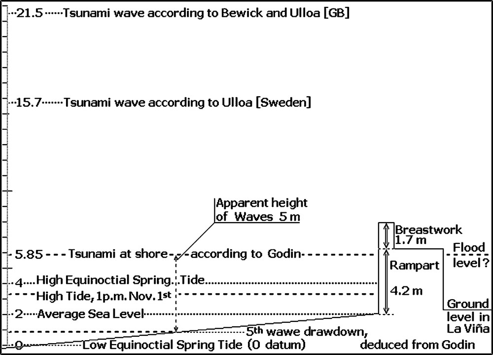
Comparison of the normal scale of hydrographic levels in Cadiz (0–4 m) and wave setting proposed by contemporary authors. That the run-up reached the height of the rampart, but not above the breastwork, is dictated by the extent of damages and inundation. The level of the base of the town wall comes from an excerpt of Godin's Spanish report in [8].
Fig. 1. Comparaison de l’échelle normale des niveaux hydrographiques à Cadix (0–4 m) et des hauteurs de vague proposées par les auteurs contemporains. Que le jet de rive ait atteint la hauteur du mur, mais sans dépasser le parapet, découle de l’étendue des dégâts et de l’inondation. Le niveau de la base du rempart provient d’un extrait du rapport espagnol de Godin en [8].
The second article by Ulloa [25] reports a water level at least 36 feet above the level that it usually reaches in the highest tides in Cadiz, i.e. 11.7 m above the High Equinoctial Spring Tide: it also mentions that the wave surrounded the ramparts, not that it overflowed them. Desvarennes [9] reconfirms that the sea broke furiously on the town walls, not that it topped over them.
Godin [11] (confirmed in Spanish excerpt [8]) gives a very moderate estimate: “the tide providing by itself at least four varas of water elevation, and the height of the waves caused by the quake being estimated to 3 varas2 in its highest oscillations.” In present terms, at Cadiz, on 1 November 1755, the mid-day inundation was 5.85 m above the Lowest Astronomical Tide level, of which 2.51 m only were caused by the tsunami.
Where was the measurement taken? A tide scale may have been affixed in the harbour, in the Bay of Cadiz, but it might not have reached high enough for the measure of a tsunami wave, and observation would have been hampered by the turmoil. Alternately, it might be the actual level of the inundation in the town quarter of la Viña. This remains speculative.
This 2.5-m figure only accounts for the swell-up of the wave. Adding the drawdown, the full amplitude must have been about twice this value: the laymen perceived 5-m-high waves running towards the town. It must also be emphasized that the wave arrived with a speed of more than 30 km h−1, and was followed by a ventral segment several kilometres long (wavelength 25 to 50 km [21]), thus causing a run-up phenomenon (dynamic piling up of the water against any obstacle: in this case, the town walls).
Accepting the high estimate [7,24] that the tsunami wave was 19.5 m above mean sea level, or 18.2 m above the 1 November normal high tide, would imply a similar calculation: the drawdown should have been about 18.2 m below tide level, i.e. 16.9 m below mean sea level. The full amplitude of the wave then should have been 36 m. Referring to a higher datum level, the apparently intermediate estimate of Ulloa [25] (11 m above normal high tide) still implies a 22-m amplitude, four times higher than that of Godin.
6 Damages to the town's walls
The damages to the town walls are also indicative of the strength of the tsunami.
All accounts of the day in Cadiz point to damages in the same area, the western front of the town wall, along the cove and beach called La Caleta, between Fort Santa Catalina and the jetty to Fort San Sebastián (Fig. 2).
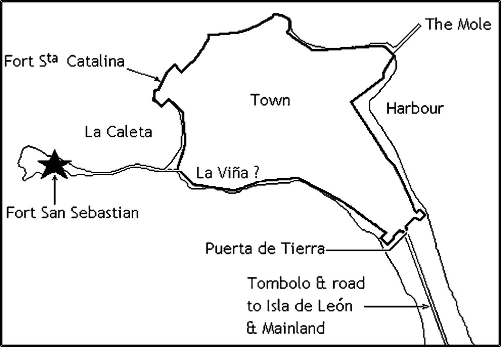
Relative position of places mentioned in the discussion of damages to the town.
Fig. 2. Croquis de position des lieux mentionnés dans la discussion des dommages à la ville.
The descriptions of the damage in the reports by Ulloa show deep contradictions. The London publication [24] states that the rampart was ruined on a length of 100 toises (195 m), carried away as sections 5.85 m long, but retaining the whole thickness of the rampart. To the contrary, the Swedish report [25] only refers to the opening of breaches in the parapet at the top of the town wall, the longest of which was 72 m long, a second 46 m, and others less important. The total damaged length may have differed little from 195 m, as mentioned in the London publication, but the pieces cast off under the impact of the wave were taken from (and retained the thickness of) the parapet, not from the rampart itself.
The differences cannot be attributed to Ulloa. They originate from the lack of rigour of a translator who was not an architect, working from a bad summary, in the editing process.
Godin's report, the most consistent one recorded in the French archives, provides us with the dimension of the town wall: the north–south wall along the Caleta was 4.18 m high. Only the parapet was brought down, and the size of the sections of masonry thrown into town by the waves remained limited: length 4.2 m, width 1.7 m, thickness 1 m. The width and thickness of the largest pieces of debris also give the height and thickness of the parapet. Additional information comes from a Spanish extract published in [8]: the base of the rampart was at average sea level. Godin's report can be trusted, as he had acted as a military architect: after the destruction of Callao and Lima by the earthquake of 28 October 1746, he took a major part in the design of the new fort known as the ‘Fortalezza del Real Felipe’, now the seat of the Historical Museum of the Peruvian Army.
At variance with Godin, Desvarennes overstated the size of the sections of the parapet that were carried away: the distance of transport compares, but their attributed length has nothing in common with other records: 58.5 to 78 m, ten times longer. Displacing pieces of masonry, the length of which would have been 58- to 78-fold their thickness, while in the previous instant the lime mortar joints had yielded to the pressure of the water that dislocated them from the wall, is a preposterous idea! This description originates from a lack of rigour, the length of damaged portions being mistaken for the size of the displaced elements.
From these early reports, it is obvious that the earthquake was perceived by all in Cadiz, but the tsunami was felt in a stronger way. The damages, though extensive, were not up to a disaster. The western seafront suffered most, but the town walls were not pulled down: only the waves dislocated, in pieces up to 4 or 5 m long, about 200 m of the 1.7-m-high breastwork, probably already loosened from the wall by the earthquake.
Only one area in town underwent flooding by seawater, the westernmost lower quarter, La Viña, behind the wall and the Caleta gate. The tsunami drowned some people there, the only casualties within town: the explanation given by Godin is that this area was 1.7 m lower than the Spring tide high level, but the sea came in through the dislocated gates.
No extensive structural damage to public buildings has been described in these texts. On the other side of the town, the water inundated public squares or church parvis a few tens of metres of distance, not depth, and left immediately. In the harbour, all goods and a few boats were washed away from the quay, but most large vessels, if not all, escaped undamaged.
7 Who was the author of the original report?
The examination of the five original texts used in this study shows how difficult it is to assess the independence of such documentary sources.
The texts published under Ulloa's name [24,25] should record the same observations, but they show strong discrepancies, beginning with the time of the earthquake, obviously wrong in the London publication, also bearing on the duration of the earthquake, on the absence of any attempt at distinguishing phases, and the absence of meteorological data – all from the same paper –, and on the height reached by the tsunami waves, very high in both reports, but different.
The London papers of Bewick and Ulloa [7,4] record the highest estimate of the tsunami wave in Cadiz. The authors belonged to very different circles (a British trader vs. a Spanish Navy Officer, Scientist & Administrator), but a strong possibility exists that these papers contaminated each other when in the hands of the editor or printer: any information missing in one can have been made up for by borrowing from the other, notwithstanding what the initial differences may have been. So many errors are found in the report attributed to Ulloa [24] that we consider it to be apocryphal: we mentioned the time of the first shock of earthquake, but even the name of ‘Isle of Lesu’ is an impossible mistake for the true Isla de León, if Ulloa were the real author: he had known the place since he was 14 or earlier! Other data mentioned, though not wrong, remain inaccurate (periodicity of the tsunami waves).
The reports having most in common are Godin's letter [11], read in Paris on 6 December 1755, and Ulloa's account in Stockholm [25], the following winter or spring 1756. However, for the mention of the outdoor temperature in the Swedish report, the meteorological observations are exactly the same, and the measurements are given in the French units (Réaumur temperatures, atmospheric pressure as height of mercury in French pouces). The differences in the time and duration of the earthquake, as well as in the distribution in phases, are more of wording than of observation. Only these two papers mention the physiological effects of the earthquake. The initial arrival time of the tsunami is the same in both; it is only surprising that the periodicity of the waves is not detailed in the Swedish report.
The ‘Real Observatorio de Cádiz’ was an annex to the ‘Real Academia de Guardias Marinas’, instituted in 1753. Godin, as the head of both, had the instrumental means of observation, in term of best clocks, thermometers, and barometers. As an astronomer and former ‘Cosmógrafo mayor’ of the colony of Peru, and a witness to the earthquake and tsunami of Lima and Callao, he also had the knowledge and experience both in earthquake observation and in marine hydrography to analyse the phenomena of the day.
As a corollary, Godin had, towards the town authorities and Spanish Crown, the responsibilities attached to the prestige of his origins and position. He established this set of data, particularly the wave-periodicity table, in order to foresee the evolution of the phenomenon, the damping meaning that the oscillation was not sustained at its origin. In addition, he ended his observations at the fifth oscillation, because he knew that the time of the high tide was passed. Very likely, he went and delivered his preliminary conclusions to the Governor: they must have been immediately the subject of a public announcement, in order to tranquillize the people, and alleviate the need to attempt a very risky abandon of the town. This explains why a French Consul would mention, in a letter to Madrid on 4 November, Godin's opinion on the duration of the earthquake.
We noted that copies of the report of Godin must remain in the historic archives of Spain [8,21]. No doubt, as an officer in the Spanish Navy and as a friend of twenty years, Ulloa has had in his hands the report of the former French Academician. Antonio de Ulloa and Jorge Juan y Santacilia were responsible for the offer of the position of head of the ‘Real Academia de Guardias Marinas’ to Louis Godin in 1751, when he learnt of his so-called resignation from the Royal Academy of Sciences of Paris. Ulloa had personally delivered to Godin, on behalf of the Marqués de la Enseñada, Minister of War, Navy, Colonies & Finances of Spain, his commission as a Colonel and his appointment as the head of the Naval School, when he first reached Madrid on his way to Cadiz [12].
Godin certainly knew the value of his observations, but he could not circulate his report to the European scientific circles: as a foreign appointee to the House of the King of Spain, he had a duty of reserve. Having been crossed out of the Royal Academy of Sciences of Paris under the pretence that he had accepted to work for a country foreign to France, he affected to send his results to, and only to, the French, in order to flatter the scientific protectionism of, and obtain rehabilitation from King Louis XV.
Godin and Ulloa may have agreed to send under Ulloa's name the report on the earthquake and tsunami to the scientific societies to which they belonged: indeed, a letter from Ulloa was read at the Royal Academy of Sciences of Paris by P. Bouguer on 3 December, the very day when Godin's letter was announced. The letter transmitted by the Count d’Argenson was given precedence, translated and recorded in the Procès-verbaux. Ulloa's letter was left aside because it conveyed the same record.
The relations between England vs. Spain & France being too tense to allow Ulloa to correspond with the Royal Society of London, the paper printed in their journal under Ulloa's name is the summary of a letter sent to the Spanish Ambassador to the Netherlands. Judging from the mistakes, it must even derive from an unfaithful oral account. We may speculate that the sixty-foot figure allocated to the height of the wave originates from mistaken hasty notes, and the spoken number could have been the phonetically close sixteen feet (5.2 m). This figure was also influenced by Bewick's estimate, who gave this height as observed “at eight miles off”, and did not mention any triangulation calculation to warrant such measurement.
Ulloa's relation to the Swedish Royal Academy of Science was delivered in French, the lingua franca of the time. The place names, all Spanish, appear as French transcriptions: Cadix (with an ‘X’), Port de Ste Marie, la Vigne, St Pierre, Cap de Ste Marie, Port de Svazo – not a harbour, but a bridge (Pont), in Spanish Puente Zuazo. The printed paper is an abstract of Ulloa's report. The content is the same as that of Godin, but there is no tsunami wave-periodicity table, and the estimate of the height of the waves is different. The omitted periodicity table can have a simple explanation: understanding not the importance of the subject in the prediction of what would follow, someone discarded it during the translation and summarizing process in Stockholm. We cannot explain whence the peculiar estimate of the wave height, 36 feet (11.7 m), comes. It is not better argued for than the most detailed one [11] or the highest, unlikely one [7,24]; so the intermediate value does not make it more reliable. The descriptions of damages to the town walls show that they were not topped over by the waves, and do not endorse such a height, probably never mentioned by Ulloa.
8 Conclusion
The documentary sources on which this study is based are primary sources of data. They are:
- • a consular handwritten letter, now in the French National Archives, further certified as to its origin by another coeval consular mail [9];
- • the Proceedings of the Royal Academy of Sciences of Paris, unpublished manuscripts bound into books, never removed from the institution [11];
- • two letters printed in the Philosophical Transactions of the Royal Society of London, the earliest scientific journal still extant [7,24];
- • another scientific letter, printed in the Acts of the Royal Academy of Sciences of Sweden, another scientific journal uninterrupted ever since [25].
The three accounts recorded under the names of Ulloa [24,25] and Godin [11] share a common set of physical data. They originate from a report established during the very event, by Godin, head of the ‘Real Observatorio de Cádiz’, to advise Don Antonio de Azlor, Governor of Cadiz, on the eventual need and risks of undertaking an abandon of the town, which happily was proven unjustified.
The classical interpretation, according to which the swell-up of the tsunami wave ranged up to 19.5 m, topped over the wall of the Caleta and pushed it into town, cannot be accepted. Only some length of the parapet was destroyed, not the town wall, and we cannot deduce from such destruction that the water flowed so massively over it. One hour and a quarter earlier, this parapet had been shaken loose by the earthquake, and this is why the breaking of the tsunami wave tore it away. However, it was a dynamic, transient phenomenon: the water level was not maintained above the top of the wall, and the flood in the low area of la Viña mainly comes from the beating open of the Caleta gate, not from continued overflow above the rampart.
The average ground level in Cadiz is 11 m above sea level. If the wave set up had been about 19 m, the engulfment of Cadiz would have left a name for the 1 November 1755 earthquake and tsunami, rather than the destruction of Lisbon. This did not happen.
Our conclusions also cast a suspicious light on the records concerning this tsunami in Morocco. It is widely accepted that the waves in Tangier reached a height of 15 m and passed over the town walls. As an example, the wording of the testimony of General Fowke, Governor of Gibraltar [10], that “the sea came up to the very walls” can be interpreted in a different way: the water may just have reached the base of the rampart. Revisiting the original records dealing with the Moroccan coasts might prove useful.
The impossibility to simulate waves higher than 10 m in Cadiz is not a flaw in the models: on the contrary, it must be borne to their credit. Adjusting a model on data obtained from ancient observations is a perilous process, as it is should require 100% confidence in these: the risk is considerable to favour options that might bring a distortion of the results towards output values, actually resulting from old misconceptions, just because such values appear to fit the data! Baptista et al. [3–5,16] have avoided this trap, as they did put into question the reliability of the most widespread reports of this tsunami in Cadiz, only lacking contemporary testimonies invalidating the alleged classical records.
Acknowledgements
The author thanks Mrs Gunilla de Marsily for the translation of the Swedish account by Ulloa into French, Mrs Oona Scotti, for the suggestion that the two phases observed in the earthquake were caused by the separate arrival of P and S waves, and Vincent Rebour, for constructive discussions on the notions and terminology used in the study of floods. These thanks also extend to J.-P. Poirier, F. Dias, and a third reviewer for their critics, suggestions… and approval.
1 A more detailed account on the earthquake and its impact on society appears in J.-P. Poirier, Le tremblement de terre de Lisbonne, Odile Jacob, Paris, 2005, 284 p.
2 The Spanish Vara was an equivalent to the yard, only shorter: 1 vara = 0.836 m.