

1 Introduction
The causes of the major Holocene environmental changes in the Mediterranean area constitute a basic issue in order to apprehend future ecosystem dynamics, in regard to the current global climate change [20]. Holocene hydrological recording is mostly inferred from river dynamics [24,30,45]. The beginning of the Holocene is characterized by high river discharge. After 7000 cal. BP, the mid-Holocene is characterized by low infilling in the valleys and incision processes. However, in this general hydrological scheme, there is a high spatial variability, with torrential events recorded during the Middle and Late Holocene [31,32].
Holocene vegetation history is mainly displayed by palynological [25,35,38,42,52], archaeobotanical [10,11,49,54] investigations, and morphosedimental and palaeobotanical studies carried out on travertine deposits [1]. Palaeoecological results underline the role of pine and juniper species during the Late Glacial/Holocene transition, followed by the development of deciduous oak forests, which dominate the landscape up to the Middle Holocene [26,34,35,51]. This palaeovegetation scheme is linked to the establishment of temperate climatic conditions [12,17,18,20,21,29,37,48]. Since 5000–4000 cal. BP, the development of agro-pastoral activities induced the regression of deciduous oak forests and the expansion of evergreen oaks (Quercus ilex and Quercus coccifera) [10,36,43,54]. This dynamics occurs asynchronously at a regional scale, related to human settlements [11,54]. The intensification of anthropogenic pressures occurring after the Bronze Age favoured the opening of the landscape and consecutively the development of matorral and, particularly, of communities dominated by Pinus halepensis [6–8,11,38,43,49].
In order to improve our understanding of the magnitude of the transformation of the Mediterranean ecosystems and ecological factors involved, it is essential to provide data at different chronological and geographical scales. Special attention must be paid to regions weakly documented, as the Mediterranean foothills of the Massif Central, where our study was carried out. The Mediterranean lowlands are poor in wetlands suitable for pollen analyses, but rich in travertine systems enclosing plant macroremains (charcoal and plant imprints). They offer the opportunity to apprehend both hydrological and landscape dynamics with high spatial resolution [1]. These natural limestone formations result from the saturation of water in soluble bicarbonate [27]. The deposit of homogenous travertine facies (calcareous deposit) requires steady environmental conditions such as regular flow and forested environments, while detrital facies indicate erosion processes, induced either by climate or human agency [27]. Charcoal fragments mostly preserved in detrital levels could result from local fire events (climatic or human induced) or from firewood used in archaeological sites. Their deposition in travertine sequences mostly occur during erosion processes affecting the surrounding slopes. Plant imprints enclosed in calcareous facies (leaves, needles, twigs, trunks, seeds and cones) result from vegetation growing on the river banks.
This paper deals with the study of the Verdus travertine system Gué des Gours (Saint-Guilhem-le-Désert, southern France), rich in plant macroremains and presenting distinct morphosedimentary facies. Data obtained allow us to recognize local Holocene palaeoenvironmental changes and to discuss the main ecological forcing involved. This site presents a relic forest dominated by Pinus nigra subsp. salzmanii, an endemic pine species growing in southern France and Spain [39]. This pine species has a restricted area in France and is genetically in danger due to hybridation with Pinus nigra subsp. austriaca, a pine species abundantly planted during the last century for soil restoration purposes [40]. The palaeoecological investigation presented in this paper allows us to retrace the dynamics of Pinus nigra subsp. salzmannii since the Early Holocene in regard to natural and/or anthropogenic disturbances.
2 Study area
The village of Saint-Guilhem-le-Désert (Hérault) is located in southern France, 40 km northwest of Montpellier (43°43′ N, °3°33′E) (Fig. 1). During the Middle Ages (804 AD), a Benedictine monastery was established in the village. Part of the material used for its construction came from travertine blocks. During this period, monks cultivated the terraces; at the bottom of the valley, traces of an irrigation system dating back to this period are still preserved. Leaning against the Séranne massif, the ‘comb of the Verdus’, where the travertine system is located (200 m a.s.l.), is partly protected from fierce northern winds. The present-day vegetation in the comb is of the Mediterranean type, with Pinus nigra subsp. salzmannii spreading on the north-facing slopes and on screes. On the south-facing slopes, Quercus ilex is dominant along with Juniperus oxycedrus, Pistacia terebinthus, Viburnum tinus and Spartium junceum. Above 400 m, Pinus nigra subsp. salzmannii dominates both on the north- and south facing slopes, in association with Buxus sempervirens, Sorbus aria, Amelanchier ovalis, Quercus pubescens, and Acer monspessulanum. The present-day climate in the area is characterized by strong seasonal contrasts, with dry and hot summers, rainy during the other seasons (800 mm yr−1). The mean annual temperature is 11 °C.

Location of the Saint-Guilhem-le-Désert area, in southern France, and stratigraphic sequence of the Gué des Gours.
Fig. 1. Localisation de la zone d’étude et stratigraphie de la séquence travertineuse du Gué des Gours.
3 Stratigraphy and sedimentation
The substratum around the village and on the surrounding elevations is composed mainly of Bathonian dolomite lithofacies. The catchment area corresponds to the plateau of Lavagne, located between Saint-Guilhem and the Seranne massif (Fig. 2). Three distinct travertine series were recognized along the Verdus River, from upstream downwards: Infernet, Abbaye, and Fonzes [4]. Two independent travertine domes, situated 200 m apart, form the Infernet system: Gué des Gours (upstream) and Arriège (downstream). The Arriège dome was built from a structural irregularity of the substratum and formed a barrage against the Verdus [4]. The Gué des Gours travertine, rich in plant remains, corresponds to the deposit where our study has been carried out. This outcrop deposited on periglacial and alluvial materials presents three distinct units (A, B, and C; Fig. 1). Unit A, where plant imprints were sampled, is composed of both detrital and travertinous facies. Unit B corresponds to the deposit of torrential materials. Unit C is composed of sand, silt (at the base) and colluvium elements (at the top).
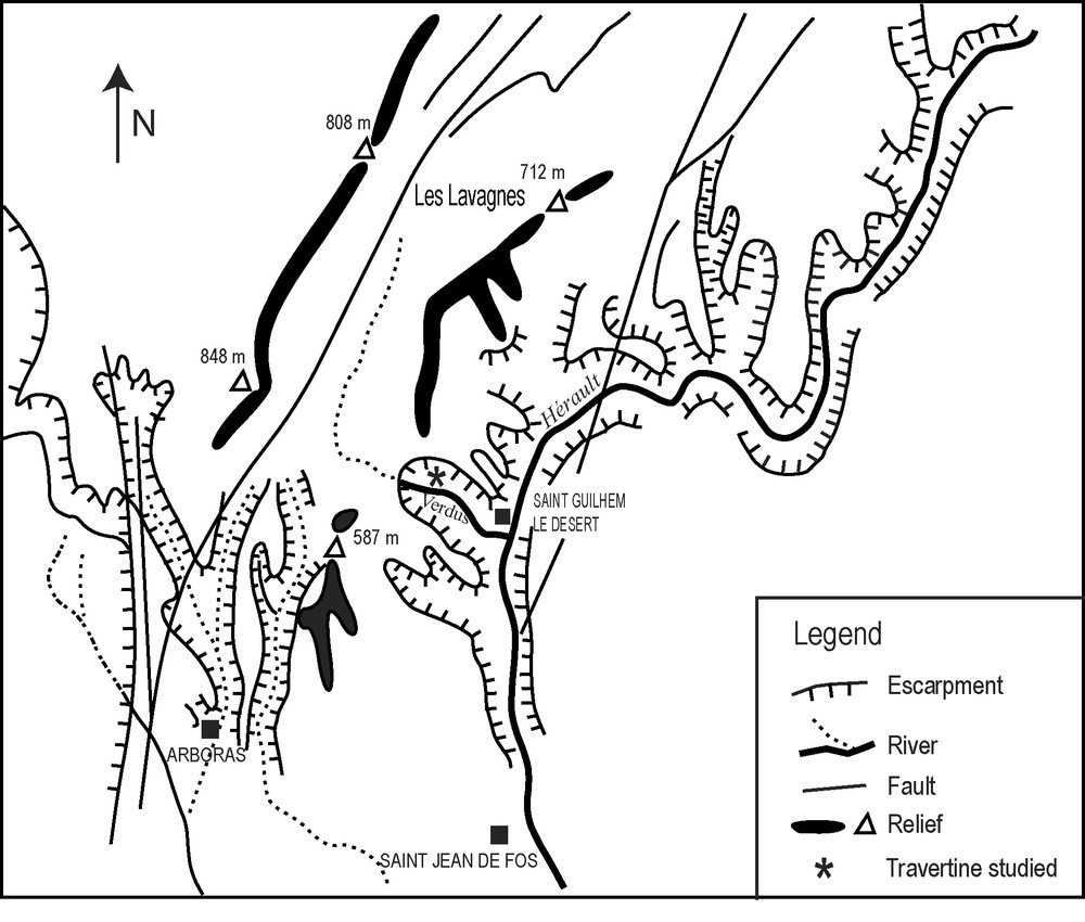
Geomorphological setting of the study area.
Fig. 2. Carte géomorphologique de la zone d’étude.
4 Materials and methods
Palaeobotanical investigations (identification of charcoal and plant imprints) and 14C dating were carried out in the different units.
4.1 Plant imprints
In Unit A, plant imprints from the travertine blocks were extracted using hammer and chisel and drawn using a stereomicroscope coupled with a camera lucida. Two levels were sampled (A1 and A3). The identification is based on comparison of morphology features with samples from reference collections (UMR 5059 and herbarium of Montpellier). Generally, the morphological features preserved in fossils allow specific identifications, which are particularly important to recognize woody-vegetation diversity. However, the reduced amount of material collected here prevents interpretation based on relative frequencies of taxa identified. Consequently, presence/absence of taxa only is used to interpret imprint assemblages.
4.2 Charcoal fragments
Charcoal fragments were sampled in all units (A, B and C) by water sieving of sediments (5- and 2-mm mesh). Specimens recovered may result from forest fires, except those from level C8e, which could come from fuel of archaeological sites, as testified to by the presence of artefacts (pottery fragments). The wood anatomical structure is preserved during charring, allowing taxonomic identification. Charcoal fragments were fractured manually according to the three anatomical planes of the wood and observed using a reflected-light microscope. One hundred to 300 fragments by level were studied. Identification was achieved by comparison with a reference collection of modern charred wood species as well as wood anatomy atlases [16,22,23,46]. The palaeoenvironmental interpretation of the successive charcoal assemblages is based on both qualitative (presence/absence) and quantitative (absolute and relative frequencies) approaches [2,3].
4.3 14C dating
Carbon-14 dating was carried out on charcoal fragments collected in six levels, using conventional and accelerator mass spectrometry (AMS) techniques. All dates were calibrated using the CALIB REV 4.4.2 program and the calibration dataset INTCAL98 [47]. Calibrated ages are rounded to the nearest 10 years.
5 Results
5.1 Dating and geochronology
The Gué des Gours travertine is an alluvial system presenting 20 m of vertical development. Table 1 shows results from 14C dating carried out in this system. The date obtained at the base of the outcrop (A2) reveals that the travertinisation process had already started at ca. 8600–8400 cal. BP (Table 1). It was interrupted at ca. 7250–6780 cal. BP (base of unit B) by the deposition of torrential materials, composed of mixed dolomite and calcareous fragments (Fig. 1). Around 5290–4870 cal. BP, this torrential period came to a stop (top of unit B) and was followed by the deposition of fine materials composed of sand and silt, corresponding likely to the establishment of a lake or a marsh (unit C) [4]. This lacustrine phase is also recorded in malacofauna analyses, allowing one to clarify the sedimentation process [5]. Five main phases have been recognized in that unit C:
- • 11 to 10: this phase is characterized by the abundance of Bithynella viridis, aquatic gastropod revealing the establishment of wetland areas (paludal);
- • 9a to 7a: the beginning of this phase is characterized by running water (paludal) and after by stagnant water (lacustrine, 8e to 7a). Aquatic species are still abundant;
- • 7: short paludal phase, characterizing the beginning of the incision of the Arriège barrage;
- • 6c and 6b: lacustrine phase with both aquatic and terrestrial species;
- • 6a to 0: these levels are characterized by terrestrial species such as Pomatias elegans and Cecilioides acicula.
14C dating from the Gué des Gours sequence (charcoal)
Tableau 1 Datations 14C obtenues sur les charbons bois interstratifiés dans la séquence travertineuse
| Levels | Material | Dating technique | 14C (BP) | Calibrated (BP) 2 δ | Lab. code |
| A2 | charcoal | Conventional | 7710 ± 60 | 8590 − 8390 | LV-1766 |
| B-base | charcoal | Conventional | 6130 ± 100 | 7250 − 6780 | LV-2181 |
| B-top | charcoal | Conventional | 4430 ± 60 | 5290 − 4870 | LV-2182 |
| C8e | charcoal | Conventional | 3440 ± 80 | 3870 − 3550 | MC-2163 |
| C4a | charcoal | Conventional | 2070 ± 80 | 2180 − 1870 | LY-4546 |
| C2b | charcoal | AMS | 925 ± 30 | 920 − 770 | Poz-10472 |
Ceramic and millstone archaeological materials were found in level C9, characteristic of the Chalcolithic period (Fontbouisse culture). Late Bronze age pottery remains were also found in level C8e, confirmed by 14C dates effectuated on charcoal (3550–3870 cal. BP). The relative abundance of various archaeological materials suggests the existence, during this period, of human occupation near the travertine system [4]. The top of the deposit with colluviums elements and dated ca 920–770 cal. BP pinpoints from the dismantling of the travertine system.
5.2 Palaeovegetation
Plant imprints collected in unit A allowed the identification of 16 species belonging to the local vegetation (Fig. 3). Most specimens come from level A1. Mesohygrophilous (Salix viminalis, Populus alba, Populus nigra) and mesophilous species (Sambucus nigra, Ulmus minor, Hedera helix, Sorbus aucuparia, and Vitis vinifera subsp. sylvestris) dominate the plant assemblage. More xerophilous species such as Buxus sempervirens, Phillyrea media and Rhamnus alaternus were also identified [41]. Two cones, identified as Pinus nigra subsp. salzmannii, were found in A3 level.
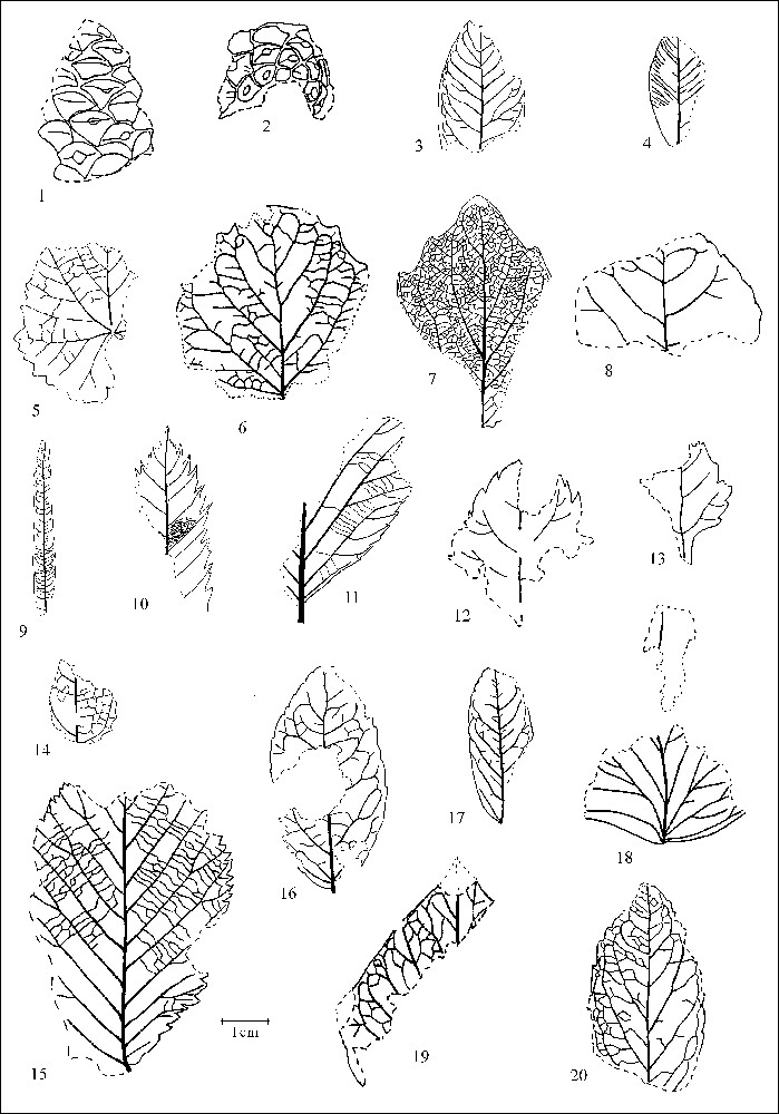
Plant imprints identified in the travertine sequence. 1–2: Pinus nigra subsp. salzmannii (cones) 3: Laurus nobilis; 4: Buxus sempervirens; 5: Vitis vinifera subsp. sylvestris 6: Populus tremula; 7: Populus alba; 8: Populus nigra; 9: Salix viminalis; 10: Sorbus aucuparia; 11: Sorbus aria; 12–13: cf. Crataegus; 14: Rhamnus alaternus; 15: Ulmus minor; 16–17: Phillyrea media; 18–19: Hedera helix; 20: Sambucus nigra.
Fig. 3. Empreintes fossiles identifiées dans le dépôt travertineux.
The taxonomic list obtained by charcoal analysis displays 4 to 12 taxa/sample, including species absent from the leaf assemblage, such as a deciduous Quercus, Quercus ilex/coccifera (evergreen oak), Taxus baccata, Olea europaea, and Juglans regia. As seen in Fig. 4, Pinus sylvestris type is present in all levels. The nomenclature used here concerning the pine fragments identified results from the absence of reliable qualitative anatomical criteria to distinguish pine species belonging to section sylvestris (Pinus sylvestris, P. uncinata, P. mugo, and P. nigra) growing in the western Mediterranean Basin, even if some authors think that this distinction is possible [57].
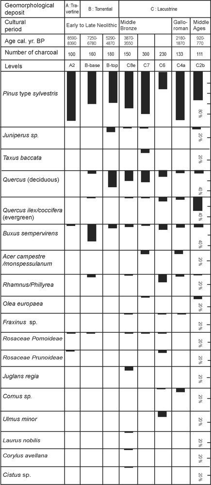
Vegetation features of the study area based on charcoal analysis.
Fig. 4. Caractéristiques de la végétation locale d’après l’analyse anthracologique.
Our results show that Pinus sylvestris type was the dominant taxon in the vicinity of the travertine system, since at least the Early Neolithic (8590–8390 cal. BP) and up to the Middle Ages. During the torrential period of the Verdus River and up to the Late Neolithic (5290–4870 cal. BP), Pinus sylvestris type was mostly associated with species of the Mediterranean oak forest such as deciduous Quercus, Buxus sempervirens, Juniperus and Rhamnus/Phillyrea. However, it is only during the Late Neolithic that deciduous Quercus reaches relative high frequencies (30%). During the lacustrine period, mesophilous taxa such as Taxus baccata, Juglans regia, Corylus avellana, Laurus nobilis, Ulmus minor, Fraxinus, Acer campestre/monspessulanum, Cornus sp., are recorded. These may have developed near the travertine sequence thanks to the new edaphic conditions. During this period, the deciduous oak forest was still present. From the Middle Bronze Age (3870–3550 cal. BP) to the Middle Ages (920–770 cal. BP), frequencies of Quercus ilex/coccifera and Rhamnus/Phillyrea increase, while deciduous Quercus declines. At the end of the sequence, Quercus ilex/coccifera developed, along with Prunoideae and Olea europaea, around the travertine system, in a regional context of increasing landscape exploitation [10,19].
6 Discussion
6.1 The hydrological dynamics of the Verdus River
The establishment and development of the travertine system of Saint-Guilhem-le-Désert is in agreement with information already obtained concerning travertinisation processes in the Mediterranean region, which started at the beginning of the Holocene [53,56]. Most of the Mediterranean travertines of southern France were formed during the Preboreal-Atlantic periods, but some travertinous formations of the Provençal Luberon Mountain began earlier, during the Tardiglacial [31].
The travertine system clearly recorded the hydrological dynamics of the Verdus River. At the beginning of the Holocene, the Verdus had a regular and stable flow, allowing the edification of travertinous facies before ca. 8590–8390 cal. BP. Between ca. 7260–6750 and 5290–4870 cal. BP, the river transported coarse alluvial materials composed of calcareous and dolomitic stones (unit B). This torrential phase, about which we do not know in the present state of results if it was continuous or discontinuous, lasted approximately 2000 years. It seems to reveal an episode of extreme precipitations around Saint-Guilhem-le-Désert.
This hydrological dynamics is different from the Holocene regional hydrological pattern supported by palaeoclimatic reconstructions [28], which point to a significant decrease in river discharge after 7200 cal. BP [15,24,30,45]. According to these studies, high river discharge occurred between 13000 and 7200 cal. BP (Principal Postglacial Infilling = PPI). However, we would like to emphasize that PPI sedimentation is mostly observed in alpine zones with a particular precipitation regime, different from that of Mediterranean areas, where abrupt rainfall occurs during the autumn, in particular in the southern Cevennes. These intensive rainfalls result from humid and warm air masses coming from the south and blocked by the relief. Also, it is important to underline the geomorphological particularity of the catchment area (plateau of Lavagnes, 400 m a.s.l.), linked with the Verdus valley through a canyon, and allowing the transport of torrential elements during stormy rainfall on the plateau. Our data underline that local events associated with specific geomorphologic features could induce particular hydrological dynamics different from the regional trend, testifying to a high spatial variability in the Mediterranean hydrological regime [13,24,31]. After these torrential spells, the Verdus flow seems to have resumed a more regular debit up to the Middle Ages (920–770 cal. BP).
The dismantling of the travertine system after the Middle Ages could be related to the local establishment of the Monastery with the exploitation of the travertine system for construction purposes. The geomorphologic dynamics of the Gué des Gours travertine is almost similar to particular dynamics described in the Luberon (Bouches-du-Rhône, southern France) [31].
6.2 Vegetation changes
From the Early Neolithic to the Middle Ages, the vegetation around the travertine system of Saint-Guilhem-le-Désert was dominated by Pinus sylvestris type. We suppose that we are dealing here with Pinus nigra subsp. salzmannii based on the local present-day vegetation, where this species occupies a large area, and because Early Holocene fossil cones of Pinus nigra were found within the travertine. Pinus nigra subsp. salzmannii needs, for its development, draining and flaky soils, as well as relatively high precipitation (1000 to 1500 mm yr−1) [39]. Its presence and development around Saint-Guilhem-le-Désert are related to local favourable environmental conditions (precipitation, colluviums, and alluvial deposits). The history of this pine species in southern France is still poorly documented. Cone imprints belonging to Pinus nigra subsp. salzmannii were found in Pleistocene travertine deposits located at Castelnau-le-Lez [14], Roquevaire [33], and Meyrargues [44] (Fig. 1), revealing that this species spread over a much larger area than at present.
According to Vernet et al. [55], the present-day fragmentation of Pinus nigra subsp. salzmannii populations is probably the result of the spatial development of deciduous and evergreen oaks during the Holocene.
Our results show that during the mid Holocene, this pine was dominant at Saint-Guilhem-le-Désert, already associated with deciduous Quercus and Buxus sempervirens (Fig. 4), corresponding to a formation close to the present-day vegetation, in the highland areas around Saint-Guilhem-le-Désert. After the Bronze Age (3870–3550 cal. BP), Quercus ilex/coccifera developed (Fig. 4). This vegetation change corresponds to the establishment of present-day vegetation in the valley. The final settlement of Quercus ilex/coccifera may be related to the opening of pine woodlands. It is important to underline that Pinus nigra subsp. salzmanni is not a competitive pine species because of its low capacity of regeneration after perturbation (fire, cutting…). However, the predominance of a pine forest in this site, since the Early Holocene up to the Present, is an unusual aspect considering other regional sites where the development of oaks corresponds to the decline of pine woodlands at the end of the Mesolithic [10,50,54]. For this reason, the later replacement of Quercus deciduous with Quercus ilex-coccifera is here probably hidden by the predominance of pine.
At a regional scale, the development of Quercus ilex/coccifera is well observed by charcoal analysis of archaeological sites, interpreted as a consequence of the exploitation of deciduous oak forests by human communities (evergreen oaks are favoured when deciduous oak is cut or/and subject to fire). It is the case at Font-Juvénal, ca. 5300 cal. BP [50], at Lattes Port-Ariane, ca. 3000 cal. BP [9], and at Sallèles d’Aude, ca. 1800 cal. BP [10]. Palynological data record the regional development of Quercus ilex/coccifera after ca. 5000 cal. BP [34,38]. Results based on charcoal analyses show that the spread of Quercus ilex/coccifera is not a synchronous phenomenon at a regional scale, depending on the development of human settlements and the extent of human activities. Consequently, we suggest that after the Bronze Age, local forcing such as anthropogenic disturbances could have favoured the local development of Quercus ilex/coccifera around Saint-Guilhem-le-Désert. Relative frequencies of both pine and deciduous oak decrease. The abundance of charcoal fragments in the travertine systems and natural soils [57] shows that fires, natural and/or anthropogenic, were and still are frequent in the area. Recurrent fire events may be largely responsible for the vegetation changes observed since the Bronze Age in the Verdus valley, resulting in the progressive regression of woodlands dominated by Pinus nigra subsp. salzmannii.
7 Conclusion
The results obtained in this multidisciplinary study (geobotanical) of the travertine system of Saint-Guilhem-le-Désert (Verdus valley) allow us to identify and understand the possible mechanisms leading to specific Holocene environmental changes in this area. The geomorphological analysis of the travertine system reveals that the Verdus River transported coarse alluvial materials between ca. 7250–6780 and 5290–4870 cal. BP, resulting probably from several local episodes of intense precipitation during this period. Later on, the river had a calm and steady flow, allowing the formation of a lake or marsh within the valley. From the beginning of the Holocene (8590–8390 cal. BP) and up to the Middle Ages (920–770 cal. BP), Pinus sylvestris type (most probably Pinus nigra subsp. salzmannii) was the predominant woody plant. Deciduous Quercus growing in the midst of the pine forest was also important up to 3870–3550 cal. BP. After this moment, the development of Quercus ilex/coccifera is noticed thanks probably to human activities.
The study of further travertine systems, which may be considered as poorly exploited palaeoecological archives, will allow us to apprehend, at high spatial resolution, environmental changes in the Mediterranean basin, in response to climatic and/or human disturbances. Several travertine deposits distributed from Spain to the Balkans are still waiting to be studied. They will provide additional information to current palaeoecological reconstructions based on pollen analyses.
Acknowledgements
Financial support was provided by the GDR 1058, “Travertins et dépressions fermées de piedmont (CNRS, France)”, supervised by Paul Ambert. We thank I. Figueiral for help in improving the English language and two anonymous referees for their helpful comments.