

1 Introduction
The long-term historical time scale has two major interests for extreme floods’ analysis. Firstly, in the scope of statistical and hydraulic studies, it provides additional information on uncommon events. Secondly, history of extreme flood management allows one to explain how society did react against catastrophic events. After a short review of the flood management of European cities during the last centuries, we present some results issued from an interdisciplinary collaboration between hydrologists and historians on extreme floods.
2 Mobilization against flood recurrence (15th–19th centuries): a public work approach
The last two decades have completely changed European flood prevention policies. Among major causes, the return of several extreme natural events in different countries is stigmatized. However, we know now that more than natural causes, the growth of territory vulnerability in relation with urbanization is the main reason for death and damage increase. The last five centuries show us that European societies in other socioeconomic contexts have already been confronted with similar situations.
Firstly, large hydrometeorological events have affected the major part of the hydrographic basins. As a consequence, fluvial crises have affected all the European states. Recent publications describe these extreme floods and propose first large chronologies [5,26]. As an example, the Catalan chronology (Fig. 1) shows three fluvial crisis periods since the end of the Middle Ages: (1) between the end of the 16th century and the beginning of the 17th century, (2) during the second part of the 18th century, (3) between the 1830 and 1870 decades. Each phase is marked by a number of major events broadly larger than average.
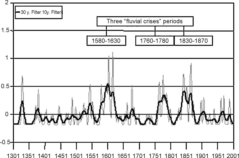
Flood chronology of Catalan rivers (14th–20th centuries). SPHERE project, University of Barcelona, Spain, July 2003.
Chronologie des crues en Catalogne (XIVe–XXesiècles). Projet SPHERE, université de Barcelone, Espagne, juillet 2003.
In the face of these recurrences, society responses are widely dependent on geographic contexts and more on economical, political and cultural situations. Urban and infrastructures development in alluvial valleys during the 18th and 19th centuries is quite different from the old socioeconomic mountain systems used to manage several natural hazards (torrent flooding, avalanche, collapse, etc.) [4,17]. However, cities are exposed to numerous catastrophic events, not only from natural origin [19]. The management capacity of public authorities and, particularly in Europe, the development of powerful States since the end of the Middle Ages have induced collective responses against Nature's excess [11]. The fluvial city case is particularly conclusive.
Inside the Po, Danube, Rhine or Rhone basins, a majority of cities firstly developed their own protections with public work systems, such as dyke alignments and dams. The objective was generally to protect, first, infrastructures (main roads, bridges, ports, walls, etc.), buildings (mills, manufactures, etc.), but also hinterlands. Generally, constructions from the 15th and 16th centuries aimed to unify or to strengthen the first urban growth infrastructures from the 12th–13th centuries [6,24]. Some civil engineering works had large sizes, like the levees along the Loire River [10]. The realization and the upkeep of these buildings show the degree of authority mobilization [12]. Besides the research of specific financial resources, authorities were faced with a technical and an urban challenge against repetitive flood destructions [8,9]. In this area, pragmatism has been the main principle of local actions, even when, in other respects, people usually considered extreme natural events as a sign of biblical disasters.
From the middle of the 19th century onwards, the urban breakwater alignments, often linked with the first large sanitation works, have been doubled by a second technical network devoted to water level monitoring and flood warning. In France, Germany and Italy, the first hydrometric scales with regular observations (at least once a day) date from the 17th century for navigation purposes. In Paris, such data are available since 1732. Its generalization at a large scale (hydrographic basins), and especially for flood warning systems, has been extended since 1830 and 1850 [7]. From this time onwards, the first emergency plans have been developed with more efficiency in relation with the water level forecasts from civil engineers and hydraulic services.
3 Use of historical data for flood risk mitigation
3.1 Hydrological research programs on historical data
The SPHERE European project [3] aimed to demonstrate the potential benefit of historical data for prevention and mitigation measures against floods. If real time actions, such as flood warning, rescue operations by civil authorities or management of hydraulic reservoirs, are usually based on hydrometeorological monitoring systems, with weather forecasting, rainfall–runoff and hydraulic models, information on past extreme events can also be useful. It gives a scale of magnitude for flood events, which helps to range the different past floods and to get a better understanding of warning messages. Emergency planning can also be established based on historical events, regarding the location of the most exposed areas (highest flooding level, flash flood dynamics).
Historical data can be considered beyond the short time scale, not only as valuable examples of catastrophic events, but also over long time intervals to assess the probability of exceedance of various thresholds of flood stage. As it is well known, the standard assessment of design floods by hydrologists is limited by the length of the record period (between 10 to 100 years), which induces a large uncertainty on extreme events due to sampling variability. Flood risk assessment can therefore be improved by including information on past floods into an adapted probabilistic framework, combining both systematic and historical data. Such better knowledge of flood hazard will reduce the uncertainties and will give a better formal basis for flood risk mitigation measures, such as flood zoning or hydraulic structures against floods (dikes and dams).
The French Ministry of Environment promoted in 1995 Flood Risk Mitigation Maps, which give: (i) information maps about flood risk, (ii) administrative rules for land use planning; (iii) recommendations on flood risk mitigation strategies. The design flood event is defined as the largest historical known flood event, and should be replaced by the 100-year flood event (i.e. with an annual probability of exceedance Prob(Q > Q100) = 0.01) if the Q100 value is greater. The choice of the reference period remains open, as a too large historical investigation may induce the selection of an old event that would be not representative of the present risk of flooding. It will be necessary to collect not only information on the water stage during peak discharge, but also information on the main temporal changes of hydraulic characteristics of the river reaches (slope, roughness, cross section, sediment process), of hydraulic works (dikes, sills, dams), and of land use.
Table 1 gives a summary of several research programs where Acthys-Diffusion and CEMAGREF have been involved, producing a set of 14 long historical discharge series. The systematic period corresponds to continuous series of annual maximum values, usually related to the activity of the Flood Warning Offices since the end of the 19th century. The historical period is based on documentary sources, which enable us to reconstruct the largest flood events of the last two or three centuries.
Set of historical discharge long series on French rivers
Reconstitution de longues séries historiques de débit en France
| Basin | Station | Systematic Period | Historical period | Research program |
| Guiers | Saint-Laurent-du-Pont | 1970–1998 | 1733–1969 | Historisque–Guiers project (1996–1997) |
| Isère | Grenoble | 1968–1998 | 1601–1967 | Cœur's Ph.D. [8] |
| Historisque–Isère project (1998–1999) | ||||
| Ardèche | Vallon and | 1980–2001 | 1644–1979 | Naulet's Ph.D. [20] |
| St Martin | Historisque–Ardèche project (1998–1999) | |||
| European SPHERE project (2000–2002) | ||||
| Gard | Alès | 1893–1980 | 1604–1891 | InondHis project (2005–2007) |
| Anduze | 1892–2005 | 1741–1891 | ||
| Mialet | 1892–2005 | 1741–1891 | ||
| St Jean | 1892–2005 | 1841–1891 | ||
| Hérault | Ganges | 1970–2005 | 1795–1969 | |
| Gignac | 1989–2005 | 1812–1988 | ||
| Aude | Orbiel | 1968–2002 | 1788–1967 | Payrastre's Ph.D [23] |
| Clamoux | 1964–1991 | 1844–1963 | InondHis project (2005–2007) | |
| Saltz | 1968–2003 | 1820–1967 | ||
| Lauquet | 1968–1996 | 1820–1967 |
The general framework for analyzing historical data for hydrological purposes was divided into three steps:
- • critical evaluation of old documentary sources, with various chronological accounts (Table 2) by departments in charge of data collection, methods and hardware for measurement, catchment events;
- • hydraulic modelling and flood event classification. As the ranking of flood stages and flood discharges may differ whenever temporal changes on riverbed occurred, it is necessary to convert water stage into discharge using hydraulic modelling. Flood marks along longitudinal profiles are valuable information for the calibration of such a model [16];
- • homogeneity tests and flood frequency analysis. Variations in climate over the last centuries can be investigated by statistical tests on historical floods [1,13]. Therefore, specific statistical tools can be used to assess flood hazard combining both systematic and non-systematic data, as well as non-stationary information [15,18].
Reading structure of historical flood information (from [21])
Grille de lecture des données historiques sur les crues (d’après [21] )
| Reading structure | Aims |
| 1. Chronological account of departments about | |
| Topography | To target the possible sources of information |
| Hydrometry and flood warning | |
| Meteorology | |
| Regional planning (forest, public works, hydroelectric energy) | |
| 2. Chronological account of methods and hardware of measurement | |
| Topography | To locate historical data |
| Hydrometry (water elevation records, flow gaugings, rating curves) | To consider uncertainties related to the measurement |
| Pluviometry (rainfall records) | |
| 3. Chronological account of catchment “events” | |
| Hydraulic structures (bridges, dikes, dams) | To convert flood stage to discharge by hydraulic modelling |
| Forests, urbanization | To consider hydrological changes on runoff processes |
| River surveying (longitudinal profile, cross sections, map) | To consider morphological evolutions of bed river |
| Low water (minimum flow level, longitudinal profile of water elevation) | |
| Hydrometric stations (flood scale) | To consider different zero elevation references of historical floods |
| Gauging, rating curve, flood marks, limit of flood prone areas | To calibrate hydraulic models |
| Maximum level of floods | To sample extreme maximum values |
| Local regulations and acts | To assess evolutions of the flood risk perception |
| Pluviometric information | To review hydrological data, and assess extreme values |
| Climatology (drought and cold periods) | To study stationarity |
3.2 Flood risk assessment on the Ardèche River
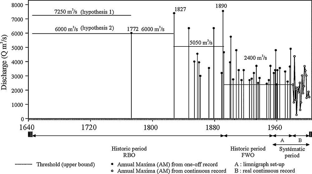
The Ardèche catchment provides a good example of the potential of historical information for flood hazard assessment [22]. The Mediterranean Sea influence produces each autumn severe rainfall when hot and moist air rises along the Cevennes hills (1500 m). Seven rainfall events exceeded a 400-mm threshold during the 1961–1996 period, among 66 rainfall events with more than 190 mm. As the upper part of the catchment is steep, with granitic and basaltic formations, flows raise to a strong magnitude in several hours. The 10-year flood discharge estimate is about 3000 m3/s at the final confluence of the Ardèche River (2372 km2) into the Rhone River. Two places have been investigated, just before and after the Ardèche canyon: Vallon-Pont-d’Arc (Vallon, 1930 km2) and Saint-Martin-d’Ardèche (St-Martin, 2240 km2). Hydrometric data is available according to three recording periods: automatic records from 1955 to today, manual systematic records by the Flood Warning Office from 1892 to 1954, and non-systematic records only during the large historical floods from 1644 at Vallon and 1827 at St-Martin. A set of 15 historical flow levels has been investigated at Vallon and St-Martin (1644–1891), with the largest flood on 22 September 1890 (17.3 m above low flow at Vallon).
A hydraulic model has been calibrated at both sites with the present conditions, using detailed information on the 1992 flood (flood marks and gauging value at Vallon of 2800 m3/s), which was a five-year flood. The model provides coherent results with the 1955 flood marks. As the riverbed elevation changed at Vallon and remained stable at St-Martin, a second model has been used for the 19th century at the former site, taking into account a detailed topographic survey of the riverbed and cross sections in 1849. The model has been validated using historical flood marks from six historical floods (1827, 1846, 1855, 1857, and 1890). It produced a quadratic difference between Surface Water Level longitudinal profiles (from historical marks and hydraulic model), which is less than 10%. Then a sensitive analysis, taking into account several parameters (downstream condition, non-permanent effect, river topography, and roughness coefficients), produced a rating curve with a confidence interval. The final uncertainty on the discharge estimate at Vallon and St-Martin is a function of the date, the water level and the available data (observed or calculated maximum level). Before 1954, the discharge error is around ±25% for small to intermediate floods, and ±60–80% for extreme historical floods, as after 1954, the corresponding errors are respectively ±10% and ±40% (small to intermediate floods, and large floods). The 1890 flood remains the largest observed flood, with a discharge estimate about 8000 m3/s at St-Martin.
The two long series at Vallon and St-Martin, from 1644 to 2000, have been used for flood frequency analysis. At St-Martin, for example (Fig. 2), a homogeneity test shows that the 11 highest floods larger than 4300 m3/s are time distributed in a stationary manner. It means that it is possible to assume the same distribution for both systematic (20th century) and non-systematic data (1644–1891) for flood hazard assessment.
Flood discharge data series at Saint-Martin-d’Ardèche (1644–2000).
Crues historiques à Saint-Martin-d’Ardèche (1644–2000).
Fig. 3 presents a comparison of three extrapolations at St-Martin: (1) Generalized Extreme Value (GEV) three-parameter distribution using only systematic data (1955–2000); (2) Gradex method [14] using rainfall information (1955–1998) and the 10-year flood (1955–2000); (3) GEV distribution using both the systematic and the 15 historical discharges, and considering that the unknown floods are lower than a perception threshold. The 100-year discharge differs from method 1 (5150 m3/s) to methods 2 and 3 (6850–7300 m3/s). It shows a good agreement between the two last approaches, which are using very different information: rainfall during the 20th century and historical discharge during the 1644–1892 period.
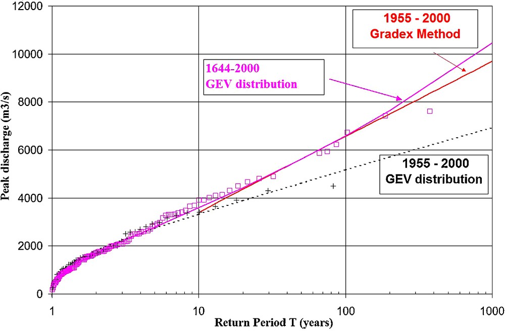
Flood distribution at Saint-Martin-d’Ardèche. +: 1955–2000 systematic period. □: 1644–2000 systematic and non-systematic periods.
Distribution des crues maximales annuelles à Saint-Martin-d’Ardèche. + : Période systématique 1955–2000. □ : Périodes systématiques et non systématiques 1644–2000.
A complementary work has been achieved by integration of palaeoflood data [25]. Geological evidence of past flood deposits can be found at specific places (Fig. 4): expansion/protected zones with vortex, back-flooded tributary zones, alcoves and flood benches. The use of slack-water flood deposits as a physical record of water surface elevations reached by past floods enables the calculation of robust palaeodischarge estimates for floods that occurred during recent centuries or millennia. Over these time intervals, numerical age dating of the sediments (e.g., radiocarbon and OSL techniques) provides the temporal framework for the structuring of the palaeoflood discharge data into different threshold levels that are exceeded by floodwaters over specific periods of time, the input data required for censored-sample maximum-likelihood flood-frequency analysis.
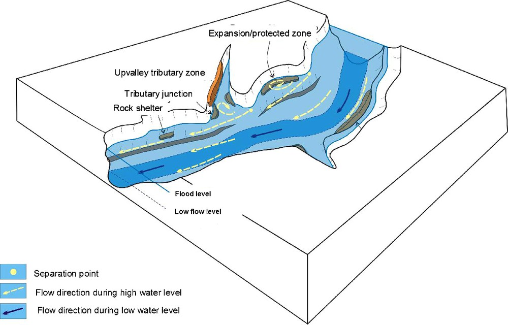
Sites of flood deposition (from [2]).
Localisation des zones de dépôt de sédiments de crue (d’après[2]).
The arch of Pont-d’Arc and the abandoned meander (Fig. 5) provide a natural separation between low flow to ordinary floods, and extreme floods [25]. As the meander elevation is 20 m above the main river, depositional units at sites AMT1 and AMT4 within the meander were used as a proxy data of the most extreme flood events of the river. AA and AC alcove sites on the right river bank provided additional testimony of exceedance of large thresholds. Dating the deposits of the four sites enabled a good correlation with the historical records, which tells us that the meander was active during the 1890 and the 1827 floods. The palaeoflood study included a detailed description of slack water flood deposits, which provided a record of individual flood events over the last two millennia. It indicates that there are long gaps in flood occurrences of the Ardèche River: the extreme floods are not randomly distributed in time, but are clustered. They also indicate that the 1890 flood, the largest flood event for the past five centuries from archive sources, remains the largest one at a two-millennium scale.
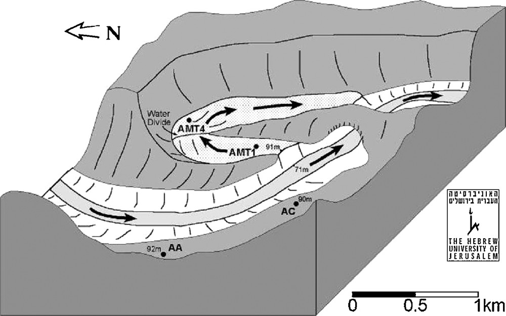
The arch of Pont d’Arc and the abandoned meander (from [25]).
Vue schématique de l’arche du Pont-d’Arc et de l’ancien méandre (d’après[25]).
4 Conclusion
Two following actions can be suggested in terms of promoting the use of historical information for flood risk management:
- • a regional flood data base should be developed, both for historical and current data. Its updating with new flood events could help society to get a feedback on recent events, with a better insight into the general stakes related to flood risk. Such a tool can be derived to specific users: civil engineers (design flood assessment), risk managers (relation between land management and catastrophic events), and the public (flood risk education and awareness);
- • a network of long historical climatic series should be promoted, with a commitment to keep a persistent/perennial management of such reference network of observation. The selection of these reference stations has to follow specific criteria: length of data series, data quality, and adequate spatial density. Such a network will provide reference data for climate change studies, both for past climatic variability and for calibration/validation of global circulation models.