

1 The Armorican Massif within the framework of the Variscan Belt
The Armorican Massif is that part of western France where the Palaeozoic basement is presently cropping out, either because it had never been covered by Meso-Cenozoic sediments or because these sediments were removed by erosion. The geological knowledge of the Armorican Massif dates back to the early mapping of Dufrénoy and Elie de Beaumont [64], later amplified through the huge effort of C. Barrois, who mapped 18 sheets at 1:80 000 scale, covering 40% of the Armorican Massif [45]. Mapping at the 1:50 000 scale will be achieved in a few years, and will provide an improved basis for drawing the geological map of France [40], which will be used as a background for the following discussion.
The Armorican Massif is a small part of a Late Palaeozoic mountain belt, the Variscan belt that extends throughout western and central Europe (Fig. 1). This mountain belt resulted from the convergence of Laurussia (= Laurentia + Baltica) and Gondwana, with amalgamation of various continental domains of peri- (or north-) Gondwanan origin, and the resorption of the intervening oceanic domains. Two such continental domains have been distinguished, namely Avalonia [163,164] and Armorica [151,187]. Long-standing discussions have taken place about their precise boundaries, the timing of their separation from the mainland Gondwana (compare, for example, Fortey and Cocks [73] and Landing [109] for Avalonia-Gondwana divergence) or even their proper existence (compare for example Matte [134] and Robardet [166] for Armorica).
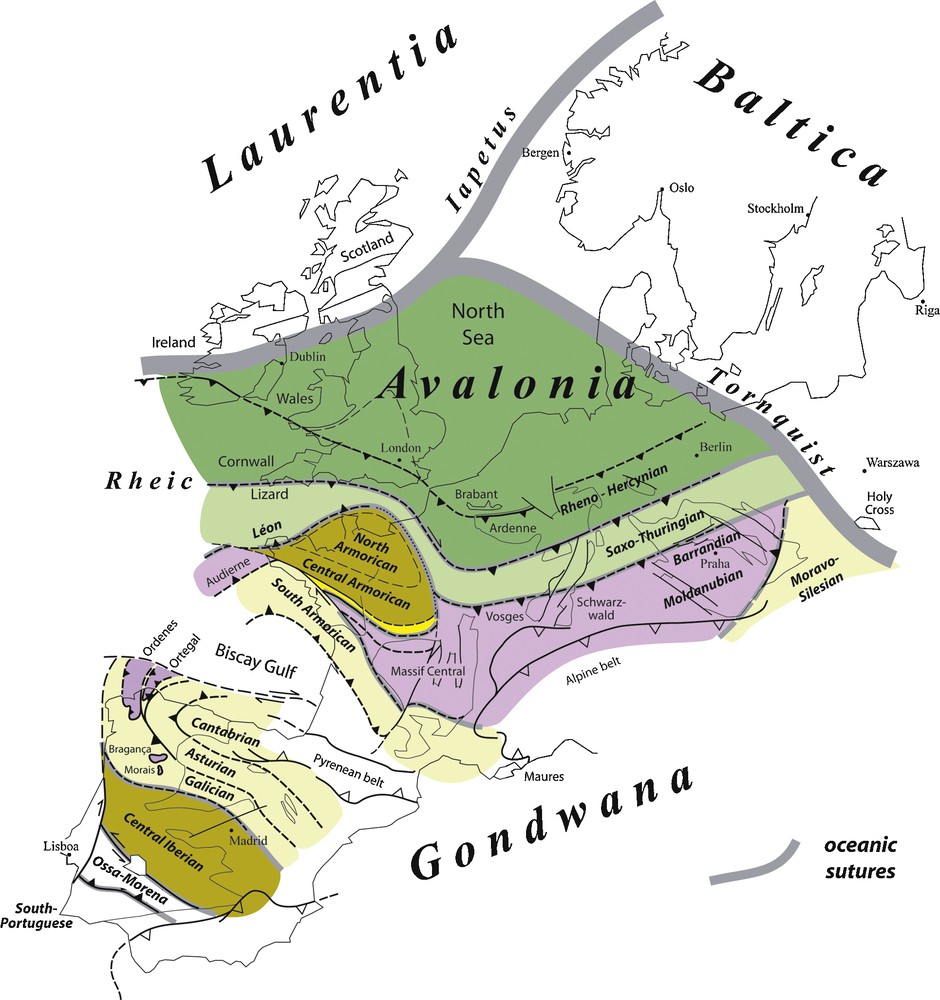
The Armorican Massif is one of several areas where Palaeozoic rocks deformed during the Variscan orogeny, crop out. The main domains in the Variscan belt vary along strike, their correlation being a matter of debate because of the non-cylindrical nature of the belt. Different colours are used to overcome the difficulties of the parochial nomenclature, and highlight potential correlations within the Variscan belt.
Fig. 1. Le Massif armoricain est une région où affleurent des roches paléozoïques déformées durant l’orogenèse varisque. Diférentes zones ont été reconnues au sein de la chaîne varisque, mais leur corrélation est un objet de débat en raison de la nature non cylindrique de la chaîne. Dans ce schéma, différentes couleurs sont utilisées pour surmonter les difficultés de nomenclature d’école et souligner les corrélations possibles entre certaines zones.
A remarkable aspect of the geology of the Variscan belt is that different terrane sequences have been developed along strike in different parts of the orogen. Fig. 1 displays the major domains/units/zones presently recognized in the Iberian Massif [131,132], in the Armorican Massif (see below) and in the eastern part of the Variscan belt, from the Vosges to Bohemia [74,75,135]. Correlations between these domains prove difficult for two main reasons. Firstly, the Cantabrian arc (a late Variscan structure) is cut along its northern side by a transcurrent fault that had a long history: a left-lateral displacement during the Permian, then the Cretaceous oceanic spreading of the Biscay Gulf and finally the shortening during the Pyrenean orogeny. It follows that any accurate correlation between Northwest Spain and western France remains conjectural, because the position of the two domains at the end of the Variscan orogeny (Late Carboniferous/Early Permain) is uncertain. Secondly, the sections in the eastern part of the Armorican Massif on the one hand, and from the Ardenne to the southern Vosges-Schwarzwald on the other hand, have few things in common (e.g. the presence versus lack of a domain with undeformed or slightly deformed Proterozoic basement). Indeed, the Meso-Cenozoic Paris Basin is deposited unconformably over a potential suture zone, which is marked by a major magnetic anomaly, whose exact significance is unclear.
The Armorican Massif is divided by Late Carboniferous, transcurrent, shear zones [77,88,96,97] into four main domains (Fig. 2), namely the Léon domain to the north-west, and the North-, central- and South-Armorican domains [e.g. 49, 102, 113]. These domains essentially differ by the amount of strain that accumulated during the Devonian and Carboniferous. Specifically, undeformed to slightly deformed Proterozoic basement is preserved in the northern- and central-Armorican domains, where it is unconformably covered by Palaeozoic sequences. During the Variscan orogeny, the North- and Central Armorican domains were pieces of continental crust that were moderately shortened and sheared between the two main suture zones. In contrast, the Léon and the South-Armorican domains have been strongly reworked during the Variscan orogeny, and the distinction between the Proterozoic basement and its Palaeozoic cover is generally obscured by the Variscan deformation and metamorphism.
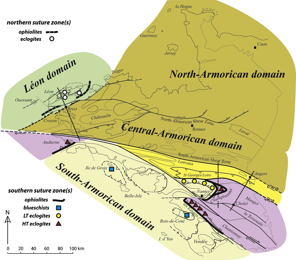
The structure of the Armorican Massif is defined by Late Carboniferous shear zones that separate domains with contrasting deformation histories during the Variscan orogeny. Two ophiolite bodies are recognized, namely the Audierne Complex (to the west) and the Folies Siffait-Drain-Le Hâvre Units, the highest unit within the Champtoceaux Complex (to the east). Eclogites (Léon, Audierne, Champtoceaux, les Essarts) are found in continentally-derived units. Blueschists (Île-de-Groix, Bois-de-Cené) are found where oceanic material has been subducted. Dashed lines indicate the location of the cross-sections.
Fig. 2. La structure du Massif armoricain est définie par des zones de cisaillement d’âge Carbonifère supérieur, qui séparent des domaines ayant des histoires différentes durant la déformation varisque. Deux complexes ophiolitiques sont identifiés, l’un en Baie d’Audierne (à l’ouest), l’autre au sommet du Complexe de Champtoceaux (à l’est). Des éclogites (Léon, Audierne, Champtoceaux, les Essarts) sont observées dans les unités continentales subductées, tandis que des schistes bleus (Île-de-Groix, Bois-de-Cené) se sont développés dans des matériaux océaniques subductés. Les lignes en tireté montrent la position des coupes.
This paper presents a summary of the geological history of the Armorican Massif, with the purpose of checking its geological evolution against the plate tectonic framework. Therefore, our main task is to identify within the Armorican Massif, major continental domains bounded by oceanic sutures. In western Europe, the Avalonia microplate, which will not be discussed later, consists of (from west to east) southern Ireland, Wales, the Lake District, South-West England and the Ardenno-Rhenish massif [47]. The Armorica microplate (in its narrowest sense) is restricted to the North- and Central Armorican domains on the one hand, and to the central-Iberian Zone on the other ([10], but see [184]) (Fig. 1). If the plate tectonic framework for Armorica proposed by Matte [134] is taken as a reference frame, one should describe the tectonic evolution of a northern suture zone (“Lizard ocean”), separating Armorica from Avalonia, and a southern suture zone (“Galicia - Massif Central ocean”), separating Armorica from Gondwana. Before considering this topic, we will briefly summarize the precollision history.
2 The precollision history
2.1 A Proterozoic basement of Gondwanan affinity
A common feature of all domains within the Armorican Massif is the occurrence of a Proterozoic basement that has been deformed at the end of the Neoproterozoic, during an orogenic event that is locally known as the Cadomian orogeny [41]. It is now widely accepted that the Armorican Massif was located at this time close to the West African craton [139,140], and therefore the Cadomian orogeny would be not only coeval with, but an integral part of, the Panafrican orogeny.
With respect to our large-scale understanding of the Variscan belt, the occurrence of a Cadomian basement alone cannot justify potential correlations between one specific domain in the Amorican Massif and other domains outside the Armorican Massif. On this basis, the proposed correlations between the central-Armorican Domain and the Ossa-Morena Zone, or the central-Iberian Zone, or the Saxo-Thuringian Zone, or the Barrandian Zone (see Fig. 1 for the location of these domains) are irrelevant. All these domains have Gondwanan affinities. However, this does not preclude that they were separated by oceanic domains, which opened during the Early Palaeozoic or during the Devonian, i.e., that they belonged to different microplates during the Variscan orogeny.
2.2 The Early Palaeozoic rifting
The Early Palaeozoic was indeed a time of continental rifting and oceanic opening, as recorded in the Armorican Massif by two independent datasets.
Firstly, the Early Palaeozoic sequences record two main episodes of continental rifting. Cambrian rifting is well-documented in the North-Armorican domain [118], and in the Mauges Unit [122,185,186]. Early Ordovician rifting is more widespread than the Cambrian rifting, being reported in the whole Armorican Massif on the basis of: (i) a large amount of aerial to subaquatic volcanics, like the Early Ordovician “porphyroids” of the Vendée [116], or the fine-grained “leptynites” of high-grade metamorphic complexes, some of them having an alkaline chemistry [12]; (ii) coeval granodioritic to granitic plutonism [95,98], intruding the Neoproterozoic to Cambrian sequences (e.g. the Lanvaux granite); and (iii) lateral changes in sediment thickness and facies, interpreted as resulting from deposition on tilted blocks [26].
Secondly, oceanic spreading is recorded by ophiolitic sequences (i.e., associations of serpentinized peridotites, metagabbros and metabasalts with bulk-rock chemistry similar to those of mid-ocean ridge basalts) that can be recognized despite deformation and metamorphism. Well-characterized ophiolitic sequences have been described in the Galician Zone [4,58,161,162], in the Lizard Complex (SW England) [141], in the western Massif Central [17,61,80], and in the Belledonne Massif [160]. The age of these ophiolites ranges from the Cambro-Ordovician to the Early Devonian. In the Armorican Massif, three ophiolitic complexes are recognized (Fig. 2), namely the Audierne Complex [18,89,128,154], the Drain-le Hâvre Unit in the Champtoceaux Complex [18,144] and potentially the Conquet metagabbro [68,70]. Geochemical data on the Audierne and Drain Complexes indicate that the mafic rocks are akin to mid-ocean ridge basalts. The age of the Audierne Complex is not yet known, and the age of the Drain-le Hâvre Unit is still uncertain [144]. On the other hand, the Conquet metagabbro, whose geochemical affinity has not been established, has provided a zircon U-Pb age of 478 ± 4 Ma [70].
In the Vendée area, the Essarts eclogites could also derive from a “lost ocean” [137]. However, petrological studies have since established the polyorogenic nature of the Essarts Complex, which records a pre-Variscan high-temperature metamorphism [82]. Therefore, the status of the protoliths of the Essarts eclogites should be reconsidered, because the assumed ocean could be unrelated to the Variscan belt.
The Île-de-Groix (and Bois-de-Cené) blueschists (Fig. 2) are thought to derive from an assemblage of tholeiitic and alkali-basalt types as observed in present-day ocean-island volcanic sequences [19], from an intracontinental rift [5] or an accretionary prism [13]. Finally, the volcanics of the Saint-Georges-sur-Loire Unit (Fig. 2) have been interpreted as recording the opening of a (small) back-arc basin, whose age is still poorly defined (Silurian to Early Devonian) [35,37,38].
Plate movement during the Early Palaeozoic is recorded by palaeobiogeographic and palaeomagnetic data. During the Cambrian and Ordovician periods, the Armorica microplate was located at a palaeolatitude close to the South Pole, as shown by the nature of Ordovician sedimentary successions and faunal communities (trilobites, ostracods…) [48,90,150,188] as well as by palaeomagnetic data [151,152]. Latitudinal migration of the Armorica microplate from the Upper Ordovician to the Middle Devonian is recorded by late Ordovician dropstones associated to the Hirnantian glaciation [167], followed by development of reefal build-ups during the Early Devonian.
Therefore, the Early Palaeozoic is interpreted as a period of widespread continental rifts coexisting with narrow oceanic domains (Gondwana break-up). No oceanic suture is recognized within or between the central- and North-Armorican domains. By contrast, ophiolitic sequences (of Cambro-Ordovician to Devonian age) are present in the South-Armorican domain.
3 The northern suture zone(s)
3.1 Key evidences in respect of the northern suture zone(s)
Evidence in favour of an oceanic domain that intially separated Armorica from Avalonia relies on two well-founded observations. Firstly, major differences in Ordovician benthic faunas are observed between the Armorican Massif (central- and North-Armorican domains) on the one hand, and Wales and the Lake District on the other hand. This difference is well-known since the time of Murchison [138, p. 437] and Kerforne [103, p. 125–130], and has been largely confirmed by later work [48,73]. Secondly, the Lizard Complex is an ophiolitic sequence of Early Devonian age [51,86,105]. It could have been part of an Early Ordovician (Arenig) to Early Devonian Rheic Ocean, or could represent a distinct, Early Devonian, Rheno-Hercynian Ocean that opened after or during subduction of the Rheic Ocean [75,76].
In the Armorican Massif, convergence along the northern suture is expected to have left few, if any traces, because the Armorica microplate was the overriding plate, and because the present-day coastline of Brittany or Normandy is located far southerly than the assumed position of the suture, hence at a distance where deformation of the overriding plate is weak or absent. However, the Léon Domain is made of metamorphic rocks of Palaeozoic age [34], and a potential oceanic suture (the Early Ordovician Conquet metagabbro [70]) has been recognized. Therefore, the integration of the Léon Domain in the framework of the Variscan belt is a source of major difficulties, and requires a careful discussion of the contact between the Léon Domain and the central- and North-Armorican domains. The contact corresponds to a major fault, the Elorn Fault, whose kinematics and age are discussed below.
3.2 Geometry and kinematics of the nappe stack
Fig. 3 shows a summary of the main Silurian to Carboniferous events in the Armorican Massif, and Fig. 4 presents a cross-section through the Elorn Fault, the emphasis being made on the relationships between the Léon domain, to the north, and the Central Armorican domain to the south. The database for constructing this figure is briefly outlined below.
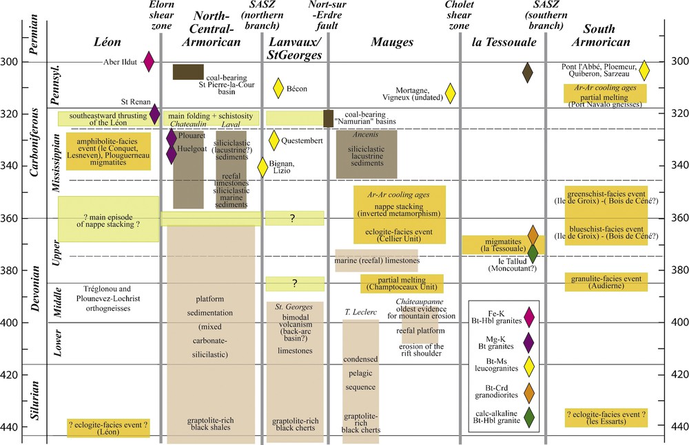
A summary of the main events recorded in the Armorican Massif during the Devonian and Carboniferous plate convergence that have resulted in the building of the Variscan belt. The sources of data are indicated in the text. The different colours refer to different types of information, indicated by the pre-orogenic sedimentary sequences (pale brown), the synorogenic sedimentary formations (dark brown), the metamorphic rocks (pale yellow) and the granitic rocks (losenges).
Fig. 3. Synthèse des évènements majeurs enregistrés dans le Massif armoricain durant le Silurien, le Dévonien et le Carbonifère, c’est-à-dire durant la période de convergence de plaques ayant abouti à la construction de la Chaîne varisque. Les différentes couleurs différencient les informations provenant des séquences sédimentaires anté-orogéniques (brun pâle) ou syn-orogéniques (brun foncé), des formations métamorphiques (jaune pâle), et des granites (losanges dont la couleur indique le chimisme du granite).

A simplified cross-section of the north-western part of the Armorican Massif (see location on Fig. 2). The Late Carboniferous Porspoder-Guissény and North-Armorican shear zones cut across a pile of metamorphic rocks with increasing grade from top (greenschist-facies Elorn schists) to bottom (migmatitic Plounévez-Lochrist orthogneisses). The Palaeozoic cover in the central-Armorican domain is deformed by south-east vergent folds, here interpreted as resulting from the (back) thrusting of the Léon Domain over the central-Armorican domain.
Fig. 4. Une coupe simplifiée de la partie nord-ouest du Massif armoricain (localisation sur la Fig. 2). Au Carbonifère supérieur, la zone de cisaillement nord-armoricaine et celle de Porspoder-Guissény recoupent un empilement de roches métamorphiques, dont le degré augmente du haut (schistes de l’Elorn dans le faciès des schistes verts) vers le bas (orthogneiss migmatitiques de Plounévez-Lochrist). La couverture paléozoïque du domaine Centre-Armoricain est déformée par des plis à vergence sud-est, ici interprétés comme résultant d’un (rétro)chevauchement du domaine du Léon sur le domaine Centre-Armoricain.
The Léon Domain consists of a pile of strongly deformed and metamorphosed rocks (Fig. 4). The northern coast of the Léon area is made by the Plouguerneau migmatites, with monazite ages of the order of 330–340 Ma (with Cadomian inherited cores) [130]. The Plouguerneau migmatites are separated from the mainland by the mylonites and ultramylonites of the Porspoder-Guissény shear zone, known onshore with a length of 25 km and a width of 500 m [42]. To the South of this shear zone, the main lithologies are, from bottom to top:
- • the Plounévez-Lochrist orthogneisses, with protolith ages at about 390–400 Ma [34,44];
- • the Lesneven paragneisses;
- • the Conquet micaschists, that are locally intruded by granitoids (Pointe des Renards);
- • the Brest orthogneiss, a granitoid intrusive within the late Proterozoic Elorn schists.
The map pattern of the biotite, staurolite and sillimanite isograds [34] documents a metamorphic grade increasing from south-east to north-west, i.e., from top to bottom of the structural pile, with well-documented clockwise P-T paths in the Conquet micaschists and Lesneven gneisses [100,101,183]. Relics of an eclogite-facies event are found in mafic lenses [31,83,106,147] within the Lesneven paragneisses, i.e., in the sillimanite zone.
This pile results from the stacking of several thrust slices. The contact between the Plounévez-Lochrist orthogneiss and the overlying Lesneven paragneiss is considered as a ductile thrust, of uncertain kinematics, that has been later folded [8] (Fig. 4). Other thrusts have been hypothesized, like the surface marked by the alignment of amphibolite-facies metagabbros found within the Conquet micaschists [68,70]. Electron-microprobe monazite dating suggests that most lithologies derive from Late Neoproterozoic – Earliest Cambrian rocks, which were subsequently metamorphosed during the Early Carboniferous, at about 340–330 Ma [68,70,183].
The nappe stack is intruded by various granitoids, the oldest one being the Saint-Renan granite, dated at 320 Ma [70] and emplaced during dextral strike-slip movement along the North-Armorican shear zone [85]. A younger intrusion, the Aber Ildut granite, dated at 301 + 7/– 3 Ma [130], and the associated Bt-Ms leucogranites, were emplaced during sinistral strike-slip displacement along the Porspoder–Guissény shear zone [112]. The latter is cut by the youngest granite of the Léon Domain, the peraluminous Crd-Bt Brignogan granite, dated at 292 ± 15 Ma [78].
The northern margin of the central-Armorican domain (south and south-east of Brest, in the northern part of the Crozon peninsula and the Plougastel area) displays Palaeozoic sediments (from the Early Ordovician to the Uppermost Devonian) unconformably resting on Late Proterozoic sequences (Fig. 4). The deformation of the Palaeozoic is characterized by reverse faults and folds associated with an axial-plane schistosity dipping towards the north-west [7,56,172]. These structures are typical of fold-and-thrust belts, with decollement levels along rheologically weaker sedimentary layers and flat-and-ramp geometries [54]. Petrological data on the aluminous metapelites indicate a metamorphic grade increasing towards the north-west, from pyrophyllite-kaolinite to chlorite-chloritoid assemblages [149]. The Carboniferous age of the south-vergent structures is well constrained, as Famennian shales are involved in this deformation. Structural and metamorphic data thus suggest that the Léon domain was thrusted over the central-Armorican domain along a SW-NE trending fault, which would parallel the Elorn valley (Fig. 4), during the Late Carboniferous.
The Early Carboniferous sediments within the Chateaulin basin are considered to be deposited either in a pull-apart basin [171], later shortened during northward thrusting along its southern boundary [55], or in a compressive basin [88]. However, the timing of the S-vergent structures along the Elorn Fault with respect to the basinal sedimentation is disputed.
4 Tectonic interpretations of the Léon Domain
4.1 Potential models
In truth, the position of the Léon Domain in the Armorican Massif is to some extent an enigma, and the above data can be interpreted according to three contrasting hypotheses.
Firstly, the Léon Domain could represent the leading edge of the overriding plate (Armorica) during the subduction of the Rheic Ocean [133]. This proposal is difficult to maintain, at least in its simplest form (where the Lizard Complex is representative of the Rheic Ocean), because one would expect to find: (i) Middle to Late Devonian calc-alkaline magmas associated with the subduction; and (ii) nappe stacking and high-grade metamorphism in the footwall of the suture zone (i.e., structurally below the Lizard Complex) rather than in its hangingwall (i.e., in the Léon Domain).
Secondly, the Léon Domain could represent metamorphic rocks that developed during overthrusting of the northern and/or central-Armorican domain towards the north-west. In this model, the Léon domain would represent the easternmost prolongation of the Saxo-Thuringian zone (Fig. 1), or, specifically, to the “Mid-German Crystalline Rise” [6,68,70,93,183]. Therefore, the tectonothermal history of the Léon domain would record the evolution of the northern suture zone(s).
Thirdly, similarities in terms of protolith ages (e.g. the presence of Ordovician orthogneisses, such as the poorly dated Brest orthogneiss [33]) and tectonothermal evolution (eclogites in the hangingwall of a ductile thrust) led Balé and Brun [8] to propose that the Léon Domain is a part of the South-Armorican domain which has been translated north-eastwards along a major dextral fault associated with the closure of the Lizard Ocean. The displacement (of the order of 300 km) would have occurred during the Devonian, and had a south-eastward thrusting component responsible for the deformation structures observed in the adjacent central-Armorican domain [8]. According to this model, the metamorphic rocks within the Léon Domain would record the tectonothermal evolution along the southern suture zone of the Armorica microplate.
The analogy between the South-Armorican domain and the Léon Domain, although generally correct, underestimates analogies with the “Mid-German Crystalline Rise” (Odenwald, Spessart). For example, this last displays (i) antiformal stacks of medium- to high-grade metamorphic rocks in the Spessart [192], with increasing grade from top to bottom [181], and (ii) highly retrogressed but indisputable eclogites in the Odenwald gneisses [193], with Lu-Hf minimun ages of about 350–360 Ma [180]. It follows that high-pressure metamorphism and nappe stacks are not exclusive to the southern suture zones. Moreover, the Léon domain is neatly distinguished from the South-Armorican domain by the occurrence of orthogneisses (Plounévez-Lochrist), with U-Pb ages (interpreted as protolith ages) at about 390–400 Ma [44,134] (Fig. 3). Similar ages have been found in the northern Phyllite Zone and the Mid-German Crystalline Rise (for a review, see [75]), where they are interpreted as recording the Late Silurian to Early Devonian arc magmatism associated with the Rheic subduction.
An additional weakness of the translation hypothesis is the lack of a significant mylonite zone along the postulated Elorn shear zone. According to Balé and Brun [8], the shear zone would be represented by pervasive ductile deformation within the Brest Orthogneiss. As proposed by Le Corre et al. [112], “the precise location of the translation is not evident, and it is more probably a rather large band including the Brest gneisses and the Elorn fault zones”. Moreover, if the displacement would have been of the order of several hundreds of kilometres as postulated by Balé and Brun [8], i.e.,, of the same order than along the South-Armorican shear zone, one would expect to find mylonitic or ultramylonitic rocks a few hundred metres thick, as is the case along the South-Armorican shear zone [96], and this is not observed. Finally, as acknowledged by Balé and Brun [8], the trace of the postulated shear zone is not found in the Morlaix area, i.e., along to the western boundary of the Léon domain.
4.2 The Léon Domain and the Normannian Nappe: a single crustal unit
In order to understand the position of the Léon Domain, we will compare its history with the northern domains of the Variscan belt in South-West England, where the Lizard Complex is of Early Devonian age. The closure of the Early Devonian ocean is recorded by: (i) extensive Frasnian turbidite sedimentation in a deep basin (Portscatho Formation, South Cornwall), with southerly-derived detrital material recording the erosion of a continental margin magmatic arc [60,72], located between Cornwall and Brittany, and called the Normannian High [194]; (ii) olistostrome development in the Roseland Breccia Formation, at the front of allochthonous units [14,117]; and (iii) northward propagating thrusts in South-West England during the Carboniferous [52,99]. Two key observations for understanding the global picture are the following:
- • Huge olistoliths (up to 1.5 km) are found below the Lizard Ophiolite within the Roseland Breccia Formation. Some of them are quartzites (Gorran Haven Formation), of Llandeilo age, and contain trilobites of Armorican affinity (e.g. Neseuretus tristani, a species otherwise unknown in Wales and England, but the most abundant species in the North- and central-Armorican domains) [178] and an endemic fauna of brachiopods [16]. The Gorran Haven quartzites are therefore interpreted as proximal deposits of the same age as the Kerarvail Member (Crozon) or May Formation (Normandy). Therefore, palaeontological data indicate that the Lizard Ophiolite is thrust over by units that represent the leading edge of the Armorica microplate.
- • Erosion of the “Normannian Nappe” [93,123], consisting of paragneisses, orthogneisses, micaschists and amphibolites, was the main source for the detrital turbiditic sedimentation in the Late Devonian basins of South-West England. A few offshore outcrops probably belong to the “Normannian Nappe” (e.g. the Eddystone Rock [123]), but one could equally search for evidence of this Nappe in the Armorican Massif itself. Indeed, assuming that the Léon Domain actually represents the eastern, onshore extension of the “Normannian Nappe” (and, as such, of the Mid-German Crystalline Rise) would reconcile the early geological history of the Variscan belt on both sides of the English Channel.
4.3 Tectonic evolution of the Léon Domain
To sum up, our preferred model for integrating the Léon Domain in the history of the Variscan belt is the following:
- • The Léon Domain comprises a Cadomian basement, overlain by Palaeozoic sediments intruded by Ordovician (?) and Early Devonian granitoids (now the Brest and Plounévez-Lochrist orthogneisses, respectively). The Early Devonian granitoids could record the subduction of the Rheic Ocean (possibly towards the south), in which case the Léon Domain would correspond to a magmatic arc.
- • The Early Devonian opening of the Lizard Ocean (in a suprasubduction zone setting?), to the North of the Léon Domain, was followed by a major episode of crustal thickening (of Late Devonian age), when the continental arc collided with Avalonia. Whether the central-Armorican Domain was being thrust over the Léon Domain at this stage [173,189] is unclear. However, the highest tectonic element of the nappe pile was part of the Armorican microplate, and would represent the northern extension of the North-Armorican domain as exposed today.
- • Exhumation of the nappe pile in the Léon Domain would have been initiated during the Late Devonian, because the sandstone petrography of the turbidites from the Gramscatho Basin, to the front of the Lizard Complex, indicates that the continental arc was “deeply dissected, supplying not only volcanic lithics and monocrystalline grains from the plutonic arc, but lithic clasts from the metamorphic basement” [72].
- • Further exhumation of the Léon Domain took place during transpressive dextral displacement along the Elorn Fault and the North-Armorican shear zone, coeval with the intrusion of syntectonic granites [85,112] (Fig. 4). This deformation left few traces in the Léon Domain (because it was already cooled, and therefore behaved essentially as a rigid body), but is recorded by the structure (southward shearing) and metamorphism (increasing gradient to the north) of the northern part of the central-Armorican domain.
5 The southern suture zone(s)
5.1 Key evidence in respect of the southern suture zone(s)
The southern suture zone can be defined in the Armorican Massif as:
- • the broad domain where crustal thickening has taken place [133];
- • the northern boundary of the eclogite- and blueschist-facies bearing units [10,37,67];
- • the root zone of the eclogite-bearing units [88].
Special attention will be paid hereafter to the Nort-sur-Erdre Fault. The latter is a brittle fault characterized by the alignment of narrow, fault-bounded, coal-bearing basins of Namurian age [27] that opened during dextral movement along its length. However, the Nort-sur-Erdre Fault bounds two domains with striking differences, and therefore is a potential suture zone at the southern margin of the Armorica microplate [10,37,97–69].
Proceeding along the same lines as for the northern suture zone(s), evidence in favour of an oceanic domain separating the Armorica microplate from the other peri-Gondwanan terranes should be based: (i) on faunal differences between the Armorican Massif and a southern continent (Gondwana); (ii) on the presence of ophiolite complexes of Cambro-Ordovician (or possibly Devonian) ages.
5.1.1 Palaeobiogeographical data
During the Ordovician, no major faunal break has ever been recognized across the southern suture zone, i.e., between the central-Armorican domain and the domains situated to the south of the Nort-sur-Erdre Fault (Vendée, Montagne Noire etc.). However, the central-Armorican domain displays benthic faunas (trilobites, brachiopods, ostracods) that are markedly different from those of the Mauges Domain. Specifically, the Ordovician of the Mauges Domain is comparable with the one from the Bohemian domain, a fact which can be explained in two ways. In a first hypothesis, the distinct faunas would reveal the existence of a large oceanic domain, now vanished, separating both units. In a second hypothesis, the Mauges and central-Armorican domains belonged to the same plate, but the deposits took place at different depths along the same margin [91,92]. This is because the dominant mechanism controlling the change in fauna is the ecology of the organisms living in shallow seas, characterized by a high degree of provincialism (central-Armorican domain) compared to those living in deeper seas (Mauges Domain), which are therefore less endemic. Because benthic organisms from very shallow or shallow depths are not known in the Mauges Domain during the Ordovician, it cannot be concluded which model is valid with respect to palaeobiogeographical data. Therefore, the Ordovician faunas do not provide a reliable test for the location of an oceanic basin.
The Devonian sequences contain either neritic faunas (“Rhenish facies”) or pelagic faunas (“Hercynian facies”) [65]. “Hercynian incursions” in an otherwise “Rhenish facies” are for example documented in a very narrow interval of Emsian age in the central-Armorican domain [120], possibly reflecting transient, higher eustatic sea-levels. In the Armorican Massif, a clear boundary between these two faunal realms has been described, with neritic faunas to the north (in the central and North-Armorican domains), and pelagic faunas to the south (in the Lanvaux, Saint-Georges-sur-Loire and Tombeau Leclerc Units). Neritic faunas are also known further south in the Châteaupanne Unit [119], the presumed cover of the Mauges Unit [62]. Unfortunately, a detailed analysis of the Devonian faunas is not available. However, the neritic faunas from the southernmost part of the central-Armorican Domain (from Erbray [15] to Angers [142]) and the Mauges Domain (Châteaupanne [119]), which are only 25 km apart in present coordinates, are similar in age (Emsian) and palaeoenvironment (carbonate platforms), but have very few species (less than 5%) in common. Pending further research, this suggests that an Early Devonian ocean could have separated the Mauges from the central- and North-Armorican domains.
5.1.2 Ophiolite complexes
At least two ophiolite complexes, namely the Audierne Complex and the Drain-le Hâvre Unit, are recognized in the southern suture zone, an assertion that seems to contradict the palaeobiogeographical data. Indeed, the latter have been used for arguing that no oceanic domain has ever existed in this area during the Ordovician [166]. Because most benthic species of trilobites and brachiopods used for such analyses had a larval stage with a rather long period of life, they could be dispersed by ocean currents over quite long distances. Therefore, palaeobiogeographic methods have (in common with palaeomagnetic methods) an uncertainty of the order of 500–1000 km, which is large enough to prevent the recognition of a former ocean.
However, subduction of a narrow ocean – whatever its age – would lead to specific metamorphic (e.g. blueschists and eclogites) and structural (e.g. nappe stacking) patterns, that would allow its recognition as a suture zone. Because such features are well-known within the South-Armorican domain (Fig. 2), we cannot escape the conclusion that at least one suture zone does exist in that domain. Thus, there are two possibilities, either: (i) the Ordovician ocean was potentially too narrow to achieve a complete separation of the benthic faunas; or (ii) an oceanic domain was not present during the Ordovician, but did develop during the Devonian.
5.2 Geometry and kinematics of the nappe stack
The following discussion is based on a time chart (Fig. 3), a map (Fig. 5) and three cross-sections (Figs. 6 and 7), which are intended to summarize data on the protolith ages and on the metamorphic structure of the area immediately north and south of the Nort-sur-Erdre Fault. The data are briefly summarized below, proceeding from north to south.

A schematic map of the Champtoceaux Complex (modified from [21]). The Nort-sur-Erdre Fault bounds to the north an antiformal stack of nappes. Two of them (the Cellier and the Champtoceaux Units) contain eclogite lenses, deriving from doleritic dykes intruding a thinned continental crust. The Drain and le Hâvre Units represent an ophiolitic complex, as the chemistry of the Drain metagabbros indicates a derivation from liquids with an N-MORB compostion [18,144].
Fig. 5. Carte schématique du Complexe de Champtoceaux (modifiée d’après [21]). La faille de Nort-sur-Erdre limite au nord un antiforme de nappes. Deux d’entre elles (les Unités du Cellier et de Champtoceaux) contiennent des lentilles d’éclogites, dérivant de filons doléritiques ayant intrudé une croûte continentale amincie. Les Unités de Drain et du Hâvre représentent un complexe ophiolitique, parce que la chimie des métagabbros de Drain indique une dérivation à partir de liquides ayant une composition de N-MORB [18,144].

A simplified cross-section of the Champtoceaux area (see location on Fig. 2). The upper section displays the main data related to the nature and age of the protoliths. The lower section is devoted to the metamorphic history. The parageneses indicated for the different units refer to the synkinematic assemblages associated with the main, nappe-forming, deformation, and postdating the eclogite-facies event in the Champtoceaux Complex. Red arrows indicate increasing metamorphic grade. It thus appears that (i) an inverted metamorphic gradient is found in the Champtoceaux Complex (with increasing T from the Mauves micaschists to the contact with the Champtoceaux migmatites), and (ii) a normal gradient is found at the base of the Mauges Unit. Geochronological data are discussed in the text.
Fig. 6. Une coupe simplifiée de la région de Champtoceaux (localisation sur la Fig. 2). La coupe supérieure montre les informations relatives à la nature et à l’âge des protolithes. La coupe inférieure est dédiée à l’histoire métamorphique. Les paragenèses indiquées pour les différentes unités font référence aux assemblages syncinématiques, associés à la déformation majeure, chevauchante et postérieure à l’épisode éclogitique. Les flèches rouges montrent le gradient d’intensité du métamorphisme. Il en ressort que (i) un gradient métamorphique inverse est observé dans le Complexe de Champtoceaux, avec une température croissante depuis les micaschistes de Mauves jusqu’aux migmatites de Champtoceaux, et (ii) un gradient normal à la base de l’Unité des Mauges. Les âges sont discutés dans le texte.
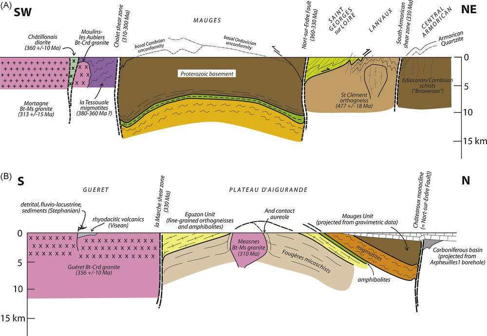
Two simplified cross-sections of the Mauges (eastern Armorican Massif) and Plateau d’Aigurande (northern Massif Central) areas (see location on Fig. 2 and 8). Please note rhyodacitic volcanics deposited on top of the Guéret granite during the Visean [24], indicating that the Guéret domain was exhumed during the Early Carboniferous. By contrast, the Measnes granite intrudes the nappe stack within the Plateau d’Aigurande domain at about 310 Ma, where it develops an andalusite contact aureole. This means that the nappe stack, although already eroded, was still at a few kilometres depth by the end of the Carboniferous. The la Marche shear zone therefore separates domains with different exhumation histories.
Fig. 7. Deux coupes simplifiées des Mauges, dans l’Est du Massif armoricain, et du Plateau d’Aigurande, dans le Nord-Ouest du Massif central (localisation sur les Fig. 2 et 8). Noter que des volcanites rhyodacitiques viséennes [24] reposent sur le granite de Guéret, indiquant que celui-ci était à l’affleurement dès le Carbonifère inférieur. En revanche, le granite de Measnes, qui développe un métamorphisme de contact au sein de l’empilement de nappes du Plateau d’Aigurande, s’est mis en place aux environs de 310 Ma. Cet empilement était donc encore à quelques kilomètres de profondeur durant le Carbonifère supérieur, la faille de la Marche séparant des domaines avec des histoires d’exhumation distinctes.
5.2.1 North of the Nort-sur-Erdre Fault
The Lanvaux Unit (Fig. 2) includes a granitic orthogneiss, cropping out either in the “Landes de Lanvaux” or in Saint-Clément-de-la-Place, and causing a negative Bouguer anomaly that can be followed along strike for more than 300 km [43,190,191]. The Saint-Clément-de-la-Place orthogneiss, dated at 477 ± 18 Ma [95], indicates a major episode of magmatism during the Early Ordovician. It is unclear whether the Bains Formation, of pre-Llanvirn age, is unconformably deposited over the Lanvaux granite, or intruded by it. The sedimentary succession continues up to the Early Devonian, which indicates that the deformation has not taken place earlier than the Middle Devonian. In the Lanvaux Unit, the steeply-dipping foliation developed during dextral movement along the northern branch of the South-Armorican Shear Zone. It is assumed that this deformation reworks an earlier foliation [66] (Fig. 6).
The Saint-Georges-sur-Loire Unit is characterized by abundant mafic, sometimes pillowed, lavas and acid volcanics, which constitute hectometre- to kilometre-sized lenses within predominantly azoic pelites. However, a few fossils have been found [110], indicating that the sediments were deposited during the Early Devonian (Pragian). Geochemical data for the mafic magmatism [30,35,37] suggest a geodynamic setting similar to present-day back-arc basins or volcanic arcs. The age of this magmatism is still poorly defined. Mafic rocks yielded a whole-rock Rb-Sr isochron of 400 ± 24 Ma, while felsic rocks have given, using the same method, an age of 350 ± 13 Ma [35]. The authors considered that they represent the age of the protoliths for the mafic lavas, but leave open a protolith or metamorphic age for the felsic lavas. More recently, Cartier and Faure [37] suggested that the felsic lenses represent olistoliths derived from the Mauges rhyolites and are therefore of Cambrian age, which is a provable hypothesis. We would rather favour a hypothesis where both mafic and felsic lavas are autochthonous, i.e., were generated during an episode of crustal extension of Early Devonian age. This would be consistent with the sedimentary record on both sides of the Saint-Georges-sur-Loire Unit, which indicates rifting at the same period [62]. In the Saint-Georges-sur-Loire Unit, the pervasive, subhorizontal or moderately-dipping, foliation displays shear criteria indicating top-to-the-north sense of shear [38,114] (Fig. 7).
5.2.2 South of the Nort-sur-Erdre Fault
To the south of the Nort-sur-Erdre Fault, the lowest tectonic element (Mauves Unit) consists of (Grt)-Bt-Chl-Ab micaschists that were intruded by a two-mica leucogranite (the Vigneux granite). A stack of thin slices that together constitute the Champtoceaux Complex developed during the thrusting. The Champtoceaux Complex [21,129] displays, from bottom to top, (i) fine-grained leucocratic orthogneisses with lenses of fine-grained eclogites (the Cellier Unit), (ii) Grt-Cld-Chl or Grt-Ky micaschists (iii) a second layer of fine-grained orthogneisses (the Saint-Mars Unit), (iv) Grt-St-Bt-Ky) metapelites, (v) a thin layer of intensely deformed amphibolites with some lenses of serpentinized peridotites (the Folies Siffait Unit), (vi) migmatitic orthogneisses with rare, poorly-preserved, eclogite lenses (the Champtoceaux Unit), and (vii) a thick layer of metaperidotites and metagabbros (the Drain Unit), potentially associated to mafic volcanics and graphite-bearing schists (le Hâvre Unit). The Champtoceaux Unit is interpreted as the core of a fold nappe affecting both the oceanic units and overlying high-grade gneisses. On top of the nappe stack, the Mauges Unit consists of a Proterozoic basement composed of grauwackes and interbedded volcanics [32], unconformably overlain by Cambrian sediments [39] and volcanics [185,186].
The Champtoceaux Complex displays at least three main phases of deformation, associated with 1) the eclogite-facies metamorphism, 2) the nappe emplacement, and 3) the large-scale folding of the nappe stack. It is generally assumed that the nappe stack results from south-verging thrusts [25,29]. However, kinematic criteria supporting this assumption have not been provided. Lagarde [108] pointed out the occurrence of two types of shear criteria. Early, ductile criteria (clast asymmetry, quartz fabric, shear bands) correspond to a top-to-the-north-west sense of shear, while later, less pervasive, criteria (shear bands) show top-to-the-north sense of shear. These fabrics, especially the early ones, are not easy to reconcile with a southward vergence of the main ductile thrusts. They rather indicate a northward vergence of the ductile thrusts.
The Cholet shear zone (Fig. 8) separates the Mauges Unit from the migmatitic gneisses of la Tessouale. Mylonites developed at the expense of the Cambrian yrholites and microgranites of the Mauges Unit as well as the la Tessouale migmatites [36,122]. Shear criteria indicate a right-lateral sense of displacement.

A tentative sketch of the correlations between the Armorican Massif and the Massif Central, based on the data discussed in the text. The petrological distinction between blueschists and eclogites has no chronological meaning. Specifically, the blueschists are about 360–370 Ma old, whereas different generations of eclogites are recognized. Early– to Middle Devonian ages have been recorded in the Massif Central eclogites (violet domain), Late Devonian eclogites in the Cellier Unit (Champtoceaux Complex) (yellow domain), and potentially Early Carboniferous eclogites in the Montagne Noire. No attempt has been made to draw the different domains to the east of the Cévennes Fault or of the Paris Basin magnetic anomaly (PBMA).
Fig. 8. Une tentative de corrélation entre le Massif armoricain et le Massif central, basée sur les données discutées dans le texte. La distinction pétrologique entre schistes bleus et éclogites n’a pas de signification chronologique. En effet, les schistes bleus sont datés aux environs de 360–370 Ma, tandis que deux (voire trois) générations d’éclogites sont reconnues. Les premières, d’âge Dévonien inférieur ou moyen, sont identifiées dans les unités allochtones supérieures, en violet sur le schéma (Audierne, les Essarts, et la majeure partie des éclogites du Massif central). Les deuxièmes, d’âge Dévonien supérieur, existent dans l’Unité du Cellier (Complexe de Champtoceaux). Une troisième génération, d’âge Carbonifère inférieur, pourrait être présente en Montagne Noire. Aucune tentative n’a été faite pour prolonger les structures observées à l’est de la Faille des Cévennes ou de l’Anomalie Magnétique du Bassin de Paris (PBMA).
To the south of the Cholet shear zone, the migmatitic gneisses (la Tessouale) record a clockwise P-T path [59,121]. They have not been dated, but similar rocks occurring slightly to the south (les Herbiers) have given monazite ages of 368 ± 7 Ma [177], interpreted as the timing of partial melting. A number of Crd-Bt peraluminous granites (Moulins-les Aubiers-Gourgé) intruded the migmatites [53].
5.3 Age of the high-pressure relics
The oldest ages for the high-pressure event have been obtained in the Essarts eclogites [81] (Fig. 2), where a lower intercept U-Pb zircon age at 436 ± 15 Ma [157] has been interpreted as recording the eclogite-facies metamorphism. Further work in this unit has convincingly demonstrated that the country-rocks of the eclogites recorded a polyorogenic history, with an early low-pressure/high-temperature event (amphibolite facies, up to partial melting in the cordierite stability field) followed by the high-pressure event (eclogite facies) [82]. These data indicate that the Essarts Unit is a piece of continental crust recording two tectonothermal cycles, whose ages remain to be established. The early HT metamorphism could be either Late Proterozoic (Cadomian) or Cambro-Ordovician. In addition, the age of the HP event cannot be safely established at present, because the polycyclic history of the Essarts Unit was not known at the time when the zircon U-Pb data have been acquired, and because the U-Pb lower intercept ages can be interpreted in several ways.
High-pressure relics (eclogite-bearing orthogneisses) in both the Cellier and the Champtoceaux Units are indicating continental subduction [9]. Indeed, in the Cellier Unit, eclogite protoliths are basic rocks which have a rather restricted composition and rare earth elements ranging from N-MORB to T-MORB types [18,81,144] and contain relict doleritic textures [81]. They can thus be interpreted as representing a former dyke swarm intruded in a thinned continental crust [11]. Eclogites from the Cellier Unit yielded dates at about 410 Ma [146] and 360 Ma [21,144]. The older date, obtained from a meta-andesite (U-Pb on zircons, lower intercept) is now difficult to interpret: the zircons recorded an isotopic memory from an older component, and the lower intercept could be attributed either to the protolith, or to the metamorphism, or to any mixture between them. The younger date, obtained on a metabasalt, is supported by two independent methods (U-Pb on zircons, upper intercept; Sm-Nd Grt-Cpx-whole-rock isochron age). The zircons do not show any memory of an older event. Moreover, phengite single grains yield 40Ar-39Ar plateau ages of 352 ± 2 Ma in the same sample [21]. Because this “young” age for high-pressure rocks was unexpected with respect to previous syntheses [159], it was tentatively dismissed according to two main lines. Firstly, the “young” ages could result from a late re-equilibration of the isotopic systems [67,69]. However, this is highly improbable, because the eclogite studied is devoid of retrogressive, amphibolite- and greenschist-facies, overprint, and because all high-pressure minerals preserve prograde growth zoning. Secondly, Cocherie et al. [46] have obtained monazite ages of 387 ± 6 Ma in the eclogite-bearing migmatitic gneisses of the Champtoceaux Unit, and therefore claimed that the eclogites dated by Bosse et al. [21] should be older than 390 Ma. However, this is an incorrect statement, because the dated samples belong to a different unit than those dated by Bosse et al. [21]. Therefore, the monazite data indicate that the Champtoceaux eclogites (which are at present undated) should be older than 390 Ma (the inferred age of the partial melting in the Champtoceaux Unit), but do not dismiss the 360 Ma ages obtained in the eclogites from the Cellier Unit. Moreover, that older ages are obtained in higher units compared to lower units is the rule rather than the exception in mountain belts, because in most cases thrusting proceeds in continental collision zones “in sequence”, i.e., structurally lower thrusts in the nappe stack are younger than structurally higher ones.
High-pressure metamorphism in the oceanic crust may largely predate the suturing. Meanwhile, the Île-de-Groix blueschists were also taken as an evidence of a high-pressure event of Silurian to Early Devonian age on the basis of a Rb-Sr whole rock isochron age of 421 ± 17 Ma and a lower intercept U-Pb zircon age of 399 ± 62 Ma obtained from detrital zircons [22,155]. Further work has shown that Rb-Sr and 40Ar-39Ar ages are similar [22], with ages of 358–366 Ma in well-preserved blueschists and 345–353 Ma in greenschists. Pending future work that could better constrain the peak temperature episode (the Sm-Nd study was unfortunately unsuccessful), the authors concluded that the age of the high-pressure metamorphism should be of the order of 360–370 Ma [22].
5.4 Erosion of a mountain belt
Another successful approach for deciphering the early convergence history consists of identifying continental (fluviatile or lacustrine) sediments or marine detrital sediments deriving from the erosion of a nearby continent. Although we recognize that identification of such sediments is a key element, they are not diagnostic of a specific geodynamic setting. Indeed, the transition from marine off-shore to near-shore detrital sediments, or fluviatile to deltaic sequences, could be the result of eustatic variations of the sea level, crustal thinning (associated to shoulder uplift), or crustal thickening.
In the Armorican Massif, the Silurian sediments are remarkably similar to those found in the whole Variscan belt, because they consist of graptolite-rich black shales (in the North- and central-Armorican domains), black cherts (in the Saint-Georges-sur-Loire Unit), or condensed, pelagic sequences (in the Tombeau Leclerc Unit). There is no evidence throughout the Variscan belt during the Silurian period of immature, coarse-grained, detrital sediments that could indicate erosion of a mountain belt. It is therefore highly improbable that the convergence is older than the Silurian-Devonian boundary, at about 415 Ma.
Continuous Devonian marine sedimentation in the North- and central-Armorican domains suggests that they were beyond the reach of the deformation associated with the initial stages of the Variscan belt. Towards the south, marine sedimentation continued during the Early Devonian in both the Saint-Georges-sur-Loire [110] and the Tombeau Leclerc and Châteaupanne Units [62,63], i.e., on both sides of the assumed suture zone. There is therefore no definite evidence for crustal thickening during the Early Devonian (from about 415 to 400 Ma) along the southern suture zone.
The situation drastically changes during the Middle Devonian (or late Early Devonian). In the Chalonnes area, the Sainte-Anne Formation displays fine- to coarse-grained immature sandstones, with abundant plant remnants indicating the proximity of an emerged land [63]. Taking into account the Emsian/Eifelian age of this formation, an emerging land (whatever the uplift mechanism) would have taken place to the South (in present geographic coordinates) of the Mauges area.
6 Tectonic interpretation of the South-Armorican domain
6.1 Correlations between the Iberian Massif and the Armorican Massif
The interpretation of the Variscan nappe stack in the South-Armorican domain is a difficult task because it has been severely dismembered by the Late Carboniferous shear zones. Therefore, useful comparisons can be made with the Iberian Massif in NW Spain (Table 1), which exposes the best section of the Variscan belt [131,132,165]. There, the nappe pile consists, from bottom to top, of the following units. The Parautochthon consists of metapelites and metagreywackes with subordinate quartzites. The Lower Allochthon is made of micaschists and fine-grained orthogneisses derived from Ordovician granites/rhyolites, which locally contain well-preserved eclogites (Malpica Tui). The latter are characterized by fine grain size, low temperature of equilibration (with glaucophane porphyroblasts), at about 600 °C [79], and a Late Devonian age for the HP event (365–370 Ma [168]). The Middle Allochthon displays strongly dismembered ophiolitic complexes, which are devoid of high-pressure relics [4,58,161,162]. The Upper Allochthon is a composite stack, with spectacular slices of peridotites, granulites and eclogites (e.g. Sobrado-Mellide, Cabo Ortegal). The latter are coarse-grained rocks, which have crystallized at relatively high temperatures (750–800 °C). The age of the HP event is disputed, being considered either Early Ordovician (480–500 Ma [71,158] or, more probably, Early Devonian (390–400 Ma [143,158,170]). Other slices within the Upper Allochthon display lower metamorphic grades. In the Iberian Massif, ophiolitic complexes separate two types of eclogite-bearing units, which are either below (Malpica-Tui) or above (Sobrado-Mellide, Cabo Ortegal) the ophiolitic sequences, and differ in P-T conditions (lower T versus higher T, respectively) as well as age (younger versus older ages, respectively).
Correlations between the nappe stacks in NW Spain, the Armorican Massif and the western part of the Massif Central.
Tableau 1 Corrélations entre l’empilement de nappes dans le NW de l’Espagne, le Massif armoricain et la partie occidentale du Massif Central.
| Iberian Masif | Armorican Massif | Massif Central | ||||||
| W Galicia | Ordenes | Ortegal | Audierne | Champtoceaux | Vendée | Aigurande | Limousin | |
| Upper Allochton | Betanzos | Penhors | Mauges | Roc-Cervelle | ||||
| O Pino, Monte Castelo and Correidoiras | Champtoceaux | Pin-Frulon-Chêniers | Upper Gneiss Unit p.p. | |||||
| Sobrado-Mellide | Cabo Ortegal (390-400 Ma) | Keramoine, Kergroaz (380 Ma) | Essarts | Eclogites | ||||
| Middle Allochton (oceanic domain) | Careon, Villa de Cruces | Ty-Lan, Peumerit | Drain - le Hâvre - les Folies Siffait | Saint-Martin-des-Noyers | Amphibolites | Peridotites and gabbros | ||
| Lower Allochton | Malpica Tui (360–370 Ma) | Santiago-Forcarei-Lalin | Saint-Mars-du-Désert, Cellier (360–370 Ma) | Orthogneisses | Dun-Gargilesse, Eguzon | Lower Gneiss Unit | ||
| Oceanic domain? | Bois-de-Cené | Génis | ||||||
| Parautochton (Gondwana) | Parano Group, Nogueira Group | Nerly | Mauves-sur-Loire | Fougères | Thiviers-Payzac |
6.1.1 The Audierne nappe stack
The closest area from the Galician section in the Armorican Massif is the Audierne region (Fig. 2) [11,94,128,156]. There, the Ty Lan serpentinites, Peumerit metagabbros and Tréogat amphibolites are considered to represent an ophiolitic sequence and have, in common with the Galician ophiolites, the lack of high-pressure relics. Slices of HP granulites (Keramoine) and eclogites (Kergroaz) are found above the metaophiolites and share, in common with the HP-HT units of the Galician Upper Allochthon, a high temperature of equilibration (19 kbar - 950 °C for the Kergroaz eclogites [128]). These slices of HP rocks would therefore represent strongly dismembered members of a once more extensive HP-HT unit. The Penhors micaschists, which occupy the uppermost structural position in the Audierne area, would be equivalent to the lower grade units of the Galician Upper Allochthon.
6.1.2 The Champtoceaux-Mauges nappe stack
The Champtoceaux-Mauges nappe stack (Figs. 3 and 4) also presents many similarities with the Galician section. The Parautochthon (the Mauves micaschists) is overthrust by the Lower Autochthon that comprises orthogneisses with lenses of low-temperature (glaucophane-bearing) eclogites. Similarities with the Malpica-Tui eclogites [10,81] have been reinforced, now that the age of HP event has been clarified in both units (360–370 Ma [21,168]). The Folies Siffait-Drain-le Hâvre units, now considered as an ophiolitic complex and devoid of HP relics, are therefore similar to the Galician metaophiolites. The Champtoceaux Unit includes migmatitic gneisses containing eclogite lenses. The partial melting has been dated at 390 Ma, and the eclogite metamorphism is therefore older than 390 Ma [46]. This situation is similar to that of the Galician Upper Allochthon. No HP-HT units are found in the Upper Allochthon, where the Mauges Unit would be equivalent to the lower-grade units within the Galician Upper Allochthon. The lack of such HP-HT units is not surprising, as we know that the nappe stack in the Galician section has been cut by major, extensional detachments. The Pallet Gabbro [107], which intrudes the Mauges micaschists (Fig. 4), can be compared with the Monte Castelo Gabbro [1–3]. Another remarkable analogy between the Galician section [84] and the Champtoceaux-Mauges stack is the difference in age of the pre-Variscan magmatism, which is slightly younger in the Lower Allochthon (480 Ma for the Cellier and Saint-Mars-du-Désert orthogneisses [12,145]) than in the Upper Allochthon (520 Ma for the Mauges Unit [186]).
6.1.3 The Vendée nappe stack
A comparison of the Vendée nappe stack [50,174] with the Galician section is also rewarding. The parautochthon would be represented by the west Vendean schists and porphyroids, the latter being derived from porphyritic volcanics 480 Ma old [116]. The lower allochthon consists of strongly deformed orthogneisses, which still retain relics of hornfelses, a feature they share with the other lower allochthonous units (Malpica-Tui [79], Cellier [129]). The Saint-Martin-des-Noyers amphibolites overthrust the orthogneisses [82] and could potentially represent strongly deformed mafic rocks from a (previously unrecognized) ophiolitic sequence (Fig. 2). Finally, and most importantly, the polyorogenic evolution of the Essarts Unit nicely matches the polyorogenic evolution of the Galician upper allochthon. Pending future geochronological work that will test the age of both events, our model is consistent with the Essarts eclogites being older and geodynamically unrelated to those of the Cellier Unit (Fig. 2). The uppermost unit of the Vendée stack (Roc Cervelle Unit) display low-grade metasandstones and metagreywackes [82], that are, for example, akin to the Betanzos Unit in the Ordenes stack.
6.1.4 The structural position of the Île-de-Groix blueschists
The main uncertainty in the South-Armorican domain concerns the structural position of the Île-de-Groix and Bois-de-Cené blueschists, which occur as klippen thrusted over the Parautochthon, and preserved within late synformal folds [25]. Therefore, they can derive from an oceanic basin located between the Parautochthon and the Lower Allochthon.
6.2 Correlations between the Armorican Massif and the Massif Central
The nappe structure of the Massif Central [28] is briefly described from bottom to top [115]. The parautochthonous unit essentially consists of metapelites and metagreywackes, which show greenschist- to amphibolite-facies metamorphism. The Lower Gneiss Unit is composed of amphibolite-facies micaschists associated with large volumes of felsic orthogneisses derived from Cambro-Ordovician volcanics or granitoids, in places displaying alkaline chemistry. The Upper Gneiss Unit is a composite stack, consisting of ultramafic-mafic bodies representing dismembered oceanic lithosphere [17,61,80], an association of amphibolites (with eclogite relics) and intensely deformed felsic orthogneisses (“complexe or groupe leptyno-amphibolique”), then migmatitic paragneisses. The Epizonal Units occupy the uppermost position, and consist of sediments and volcanics of Palaeozoic age (up to the Late Silurian/Early Devonian) (Thiviers-Payzac), and of greenschist-facies mafic volcanics associated to a few metacherts (Génis).
6.2.1 From Champtoceaux to Aigurande
Three domains of the eastern part of the Armorican Massif (i.e., the Lanvaux, Mauges and la Tessouale domains) are cut through by the South-Armorican Shear Zone to the west, and are unconformably overlain by Mesozoic sediments to the east (Fig. 2). A potential prolongation of these domains should be found in the northernmost part of the Massif Central (Fig. 8).
The eastward prolongation of the Nort-sur-Erdre Fault can be traced for more than 200 km, as minor synsedimentary faulting and folding (Châteauroux monocline, Arpheuilles anticline) associated with the fault is documented in the southern part of the Meso-Cenozoic Paris Basin [124–127]. Moreover, some boreholes have reached the Palaeozoic basement below the Mesozoic-Cenozoic cover (Arpheuilles1 borehole [179]), and have proved relics of coal-bearing basins along the Fault.
A nice analogy does exist between the Champtoceaux-Mauges area and the Plateau d’Aigurande area (Table 1). In the latter, the nappe stack displays, from bottom to top, a lower unit essentially made of Grt-Bt-Chl micaschists (Fougères Unit = Mauves Unit = Parautochthon), then fine-grained orthogneisses, amphibolites and Grt-Bt-St-Ky micaschists (leptyno-amphibolitic group, Dun-Gargilesse or Eguzon Units = Cellier and Saint-Mars Units = Lower Gneiss Unit), and finally migmatitic gneisses (Pin-Frulon-Chéniers Unit = Champtoceaux Unit = Upper Gneiss Unit). Therefore, one common feature with the Champtoceaux Complex is the occurrence of an inverted metamorphic gradient [57,175]. Another common feature with the Champtoceaux Complex is the presence of relics of very fine-grained eclogites [104] in the “leptyno-amphibolitic gneisses”. The antiformal nappe stack is intruded by the Crevant and Crozant Bt-Ms leucogranites, dated at 312 ± 6 Ma [153] and 312 ± 20 Ma [176], respectively. These granites are therefore analogous with the Vigneux granite, which intrudes the core of the Champtoceaux antiform (Fig. 5).
To the South of the Aigurande nappe stack, another analogy can be proposed between the Tessouale domain and the northern Limousin. As recognized by Dhoste [59], the Crd-Sil migmatites of the Tessouale are similar to those of Aubusson, the latter being dated at 356 ± 8 Ma [111]. The peraluminous granitoids of Moulins-les Aubiers-Gourgé are similar in chemistry and age to the Guéret granite dated at 356 ± 10 Ma [20].
6.2.2 From the Vendée to the Limousin
The Vendée area is close to the Limousin area in the western part of the Massif Central. A close comparison of the nappe stack in both areas encounters two problems.
Firstly, the recognition and location of the oceanic units in the Limousin is disputed. However, the petrology and structure of the ultramafic-mafic bodies argues convincingly in favour of their oceanic origin. These bodies would represent strongly dismembered pieces of an oceanic lithosphere [17,61,80]. Because they are located at the boundary between the Lower and Upper Gneiss Units, and because they are devoid of HP relics, we propose to attribute them to the Middle Allochthon (Table 1).
Secondly, the position of the Thiviers-Payzac and Génis units in the nappe stack is open to debate. The Thiviers-Payzac presents many similarities with the Vendée area, including large amounts of porphyritic felsic metavolcanics (“porphyroids”) of probable Early Ordovician age [23]. The sedimentary record of the Thiviers-Payzac Unit proceeds up to the Latest Silurian/Earliest Devonian [87]. On top of this sequence, the protoliths of the Génis Unit, composed of greenschist-facies mafic volcanics (with MORB chemistry) with rare metacherts, present similarities with the Groix-Bois-de-Cené Units.
Most authors consider that the Thiviers-Payzac and Génis units belong to the uppermost Epizonal Unit [115], which implies that they are separated from the Upper and Lower Gneiss Units by a thrust. A structural analysis of the tectonic contact between the Thiviers-Payzac and Upper Gneiss units indicates that the faulted contact is a left-lateral shear zone (Estivaux shear zone [169]) rather than a thrust. One could therefore consider that the Thiviers-Payzac Unit could represent the parautochthon, in which case the Génis Unit can be considered as an along-strike equivalent of the Île-de-Groix – Bois-de-Cené nappe (Fig. 8), i.e., a klippe of ocean-derived material.
Following the above discussion, we consider that the nappe stack in the Limousin consists, from bottom to top, of the Parautochthon (Thiviers-Payzac), the Génis Nappe, the Lower Allochthon (= Lower Gneiss Unit), the Middle Allochthon (ultramafic-mafic bodies devoid of HP metamorphism, previously considered as part of the Upper Gneiss Unit) and the Upper Allochthon (eclogite-bearing, migmatic gneisses of the Upper Gneiss Unit). Such an interpretation is consistent with the nappe stack described in Galicia, and found throughout the Armorican Massif from Audierne to the Vendée (Table 1).
7 Tectonic models of the Armorican Massif
The review given above has shown striking similarities between nappe stacks in NW Spain, the South-Armorican domain and the Massif Central. Our interpretation of the nappe stack in the Armorican Massif and the Massif Central is at variance with previous interpretations on one major point: the location of the oceanic suture. The classic interpretation [134] assumes that all eclogite-bearing units develop during subduction of the continental, Gondwana-derived, crust, and therefore lie below the ophiolitic suture. In this hypothesis, the eclogites are attributed to a single HP event, of Siluro-Devonian age [69,159]. On the other hand, we consider that the ophiolitic suture separates two types of HP units, as is well documented in Galicia. In the footwall of the oceanic suture (i.e., in the Lower Allochthon), eclogites mainly derive from doleritic dikes cutting across Early Ordovician granites, and display relatively low temperatures of crystallization: these have given a Late Devonian age for the HP event [21,168]. In the hangingwall of the oceanic suture (i.e., in the Upper Allochthon), eclogites representing former gabbroic complexes (e.g. in the Essarts or la Bessenoits in the Massif Central), have recrystallized at relatively high temperatures (in excess of 700 °C), and have provided well-constrained Early Devonian ages for the HP event [148].
This two-fold subdivision of the eclogite-facies rocks in the Variscan belt has major implications for its evolution. The following discussion is therefore intended to explore different models for the large-scale structure of the Armorican Massif (Fig. 9). The different models have in common the identification of at least two suture zones, with remaining uncertainties being attached to both the vergence and the age of these sutures.
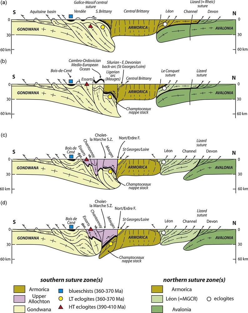
Four potential models for the Armorica microplate boundaries, with increasing complexity from top to bottom. The models are conceptual, but serve to pinpoint the key issues in any discussion of the Armorica microplate. For sources and details, please refer to the main text. MGCR: Mid-German Crystalline Rise.
Fig. 9. Quatre modèles potentiels des limites de la microplaque Armorica., modèles de complexité croissante de haut en bas. Ces modèles conceptuels servent à focaliser la discussion sur les questions majeures quant à l’évolution de la microplaque Armorica. Les sources et les détails sont discutés dans le texte. MGCR : Ride Cristalline de l’Allemagne moyenne.
Model 1 [134] recognizes an Armorican microplate bounded by two suture zones of opposing vergence (Fig. 9a). To the north, the Armorica microplate is overthrusting the southern margin of the Avalonia microplate, with the intervening Lizard suture. To the south, Armorica would overthrust the Gondwana continent, due to the closure of an Ordovician ocean and subsequent Silurian to Early Devonian continental subduction. According to this simple and elegant model, all terrains located north of the Nort-sur-Erdre Fault would belong to the Armorica microplate, whereas the Champtoceaux – Aigurande nappe stack would mark the northernmost exposure of the thickened, Gondwana-derived, crust.
This model does not specify where, in the Armorican Massif, are located the potential relics of the Ordovician ocean, nor does it discuss the meaning of the Saint-Georges-sur-Loire Unit. In addition, it does not agree with the ages of the high-pressure event in the Champtoceaux Complex [21,136], nor does it take into account the kinematics of the thrusting in the Champtoceaux Complex [108].
Model 2 [37,38,68,69] recognizes:
- • a northernmost (Lizard) suture separating Avalonia from an intermediate continent (Léon);
- • a northern (Conquet) suture separating the intermediate continent (Léon) from Armorica, and having a northward vergence;
- • a southern suture zone, corresponding to the closure of the Saint-Georges-sur-Loire basin (of back-arc origin), and displaying a northward vergence;
- • a southernmost suture zone, associated with subduction of the “Medio-European Ocean” (Fig. 9b).
This subduction is thought to have occurred during the Late Ordovician/Early Silurian (450-430 Ma), associated with the development of the “Ligerian arc” (= Mauges) and the opening of a back-arc basin (“Layon rift” = Saint-Georges-sur-Loire). Closure of the back-arc basin would have taken place during the Early Devonian (410–390 Ma) by northward subduction below Armorica, following continental subduction associated with eclogite formation during the Silurian (430–410 Ma). The Nort-sur-Erdre Fault marks the boundary between two suture zones of opposing vergence.
With respect to model 1, model 2 has a great potential value because it clearly recognizes the Drain Unit as an ophiolite complex of Cambro-Ordovician age (which remains to be established), and the allochthonous Mauges Unit as an independent, small-scale, plate of Armorican derivation. All terrains either below the Drain Unit, or to the South of the South-Armorican Shear Zone belong to the deformed Gondwana palaeomargin. However, it raises several problems. Firstly, the interpretation of the Saint-Georges-sur-Loire Basin as a back-arc basin raises the question of the location of the coeval calc-alkaline arc. Recognizing the lack of the latter, Faure et al. [69] have assumed that the “missing domain” was subducted, an assumption which is difficult or even impossible to check. Secondly, model 2 assumes that all eclogite-bearing units are located below the suture zone, and therefore does not encompass the observed differences in P-T conditions and age. Thirdly, model 2 is contradicted by the geochronological data, which indicate that the Cellier eclogites developed at 360–370 Ma (see above), not at 430–410 Ma.
Models 3 and 4 follow the interpretation of the nappe stack with reference to the Galician section, and assume that the Essarts, Chantonnay and Mauges units all belong to the Upper Allochthon, i.e., they are located above an oceanic suture represented by the Drain metagabbros. The northernmost part of the Gondwana plate, i.e., the Lower Allochthon (Champtoceaux) would have been subducted below this oceanic unit during the Late Devonian. In model 3, the Upper Allochthon overthrusts Gondwana-derived units. Model 4 differs from model 3 with respect to the vergence of the main thrusts: the Upper Allochthon is thrust towards the south along a southern suture, but towards the north along a northern suture, in order to take into account the kinematic data from the Champtoceaux nappe stack [108].
Both models 3 and 4 fit the available geochronological data, taking into account that the Cellier eclogites have different P-T histories and different ages with respect to most eclogites from the Massif Central. The Cellier eclogites are related to the final suturing of the Gondwana (or Armorica) and “Upper Allochthon” plates, whereas the Essarts and Massif Central eclogites would represent an earlier, unrelated, event in the Upper Allochthon, whose significance is open to debate. The Upper Allochthon is poorly represented in the Armorican Massif, but is better preserved in the Iberian Massif [84], where it is interpreted as the northern margin of the Gondwana continent (Cambrian), separated during the Early Ordovician from Gondwana during southward subduction of the Tornquist Ocean and coeval opening of the Rheic Ocean (interpreted as a back-arc basin). Alternatively, the Upper Allochthon (i.e., the Upper Gneiss Unit of the Massif Central) could potentially continue to the Vosges-Schwarzwald and the Moldanubian of the Bohemian Massif [74,135,182], and represent the westward continuation of a continental arc that was constructed during the Early Carboniferous (Fig. 1).
Acknowledgments
The authors would like to thank the organizing committee of the meeting on the Mechanics of Variscan Orogeny, dedicated to Philippe Matte (Orléans, 13–15 September 2007), namely M. Faure, J.-M. Lardeaux, P. Ledru, A. Peschler and K. Schulmann, as well as the participants to this meeting for sharing their knowledge of the Variscan belt. Two formal reviewers (F. Simancas and J.-B. Edel) helped clarify the issues. The content of this paper remains, as usual, the full responsibility of the authors.